
|
| |||||||||||||||||||

|
Please note that JDLand is no longer being updated.
JDLand.com Search
- Full Neighborhood Development MapThere's a lot more than just the projects listed here. See the complete map of completed, underway, and proposed projects all across the neighborhood.
- What's New This YearA quick look at what's arrived or been announced since the end of the 2018 baseball season.
- Food Options, Now and Coming SoonThere's now plenty of food options in the neighborhood. Click to see what's here, and what's coming.
![-]()
- Anacostia RiverwalkA bridge between Teague and Yards Parks is part of the planned 20-mile Anacostia Riverwalk multi-use trail along the east and west banks of the Anacostia River.
![-]()
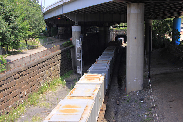
- Virginia Ave. Tunnel ExpansionConstruction underway in 2015 to expand the 106-year-old tunnel to allow for a second track and double-height cars. Expected completion 2018.
![-]()
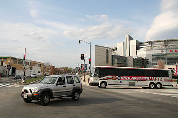
- Rail and Bus Times
Get real time data for the Navy Yard subway, Circulator, Bikeshare, and bus lines, plus additional transit information. - Rail and Bus Times
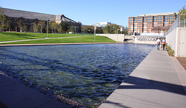
Get real time data for the Navy Yard subway, Circulator, Bikeshare, and bus lines, plus additional transit information. - Canal ParkThree-block park on the site of the old Washington Canal. Construction begun in spring 2011, opened Nov. 16, 2012.
![-]()
- Nationals Park21-acre site, 41,000-seat ballpark, construction begun May 2006, Opening Day March 30, 2008.
![-]()
- Washington Navy YardHeadquarters of the Naval District Washington, established in 1799.
![-]()
- Yards Park5.5-acre park on the banks of the Anacostia. First phase completed September 2010.
![-]()
- Van Ness Elementary SchoolDC Public School, closed in 2006, but reopening in stages beginning in 2015.
![-]()
- Agora/Whole Foods336-unit apartment building at 800 New Jersey Ave., SE. Construction begun June 2014, move-ins underway early 2018. Whole Foods expected to open in late 2018.
![-]()
- New Douglass BridgeConstruction underway in early 2018 on the replacement for the current South Capitol Street Bridge. Completion expected in 2021.
![-]()
- 1221 Van290-unit residential building with 26,000 sf retail. Underway late 2015, completed early 2018.

- NAB HQ/AvidianNew headquarters for National Association of Broadcasters, along with a 163-unit condo building. Construction underway early 2017.

- Yards/Parcel O Residential ProjectsThe Bower, a 138-unit condo building by PN Hoffman, and The Guild, a 190-unit rental building by Forest City on the southeast corner of 4th and Tingey. Underway fall 2016, delivery 2018.

- New DC Water HQA wrap-around six-story addition to the existing O Street Pumping Station. Construction underway in 2016, with completion in 2018.

- The Harlow/Square 769N AptsMixed-income rental building with 176 units, including 36 public housing units. Underway early 2017, delivery 2019.

- West Half Residential420-unit project with 65,000 sf retail. Construction underway spring 2017.
![-]()
- Novel South Capitol/2 I St.530ish-unit apartment building in two phases, on old McDonald's site. Construction underway early 2017, completed summer 2019.
![Novel South Capitol]()
- 1250 Half/Envy310 rental units at 1250, 123 condos at Envy, 60,000 square feet of retail. Underway spring 2017.
![-]()
- Parc Riverside Phase II314ish-unit residential building at 1010 Half St., SE, by Toll Bros. Construction underway summer 2017.
![-]()
- 99 M StreetA 224,000-square-foot office building by Skanska for the corner of 1st and M. Underway fall 2015, substantially complete summer 2018. Circa and an unnamed sibling restaurant announced tenants.
![-]()
- The Garrett375-unit rental building at 2nd and I with 13,000 sq ft retail. Construction underway late fall 2017.
![-]()
- Yards/The Estate Apts. and Thompson Hotel270-unit rental building and 227-room Thompson Hotel, with 20,000 sq ft retail total. Construction underway fall 2017.
![-]()
- Meridian on First275-unit residential building, by Paradigm. Construction underway early 2018.
![-]()
- The Maren/71 Potomac264-unit residential building with 12,500 sq ft retail, underway spring 2018. Phase 2 of RiverFront on the Anacostia development.
![-]()
- DC Crossing/Square 696Block bought in 2016 by Tishman Speyer, with plans for 800 apartment units and 44,000 square feet of retail in two phases. Digging underway April 2018.
![DC Crossing]()
- One Hill South Phase 2300ish-unit unnamed sibling building at South Capitol and I. Work underway summer 2018.
![One Hill South Phase 2]()
- New DDOT HQ/250 MNew headquarters for the District Department of Transportation. Underway early 2019.
![New DDOT HQ]()
- 37 L Street Condos11-story, 74-unit condo building west of Half St. Underway early 2019.
![37 L Condos]()
- CSX East Residential/Hotel225ish-unit AC Marriott and two residential buildings planned. Digging underway late summer 2019.
![CSX East Residential/Hotel]()
- 1000 South Capitol Residential224-unit apartment building by Lerner. Underway fall 2019.
![1000 South Capitol Residential]()
- Capper Seniors 2.0Reconstruction of the 160-unit building for low-income seniors that was destroyed by fire in 2018.
![1000 South Capitol Residential]()
- Chemonics HQNew 285,000-sq-ft office building with 14,000 sq ft of retail. Expected delivery 2021.
![1000 South Capitol Residential]()


Search term: (meetings) : 194 matching blog entries
Transportation Study Meeting and Other Tidbits
Nov 26, 2018 11:32 AM
And now some of increasingly old tidbits:
* ALBI/MAXWELL: Washingtonian reports news of two restaurants coming to the Yards in 2019: Albi, a "modern American eatery inspired by {chef Michael Lee Rafidi's} Middle Eastern and Mid-Atlantic roots," and another branch of Shaw's "oenophile haven," the wine bar Maxwell. The JDLand commentariat has analyzed the situation and are positing that the new garage door-style panels on the 4th Street side of the Bower might be the home for these ventures.
* CHEMONICS: Not a restaurant, but Washington Business Journal reports behind its paywall that Chemonics, a USAID contractor among other things, is close to a deal to move its 1,200-person headquarters from near Farragut West to Yards Parcel A Yards Parcel G (updated 1/2/19 with the correct location--oops). This northern portion of Spooky Park has long been planned to be Class A office space--as for the rest of the block, I wrote a few weeks ago about the plans for residential along N Street and the new streets coming. This new office building would be north of the hotly awaited Quander Street. (h/t commenter Westnorth)
* SQUARE 696 UNMASKED? With thanks to commenter CL85, we may have our first look at what is coming to Square 696, the block just about out of the ground on the south side of I Street between Half and 1st. (If Clark pulls it down, here is the rendering.) This is going to be an 818-unit residential project spanning the entire block when both phases are complete in 2022. (It sounds like they are going to build the "structure and skin" of the entire project, but will first complete the eastern tower before moving to the interior work of the western tower.)
* NEW BIKESHARE STATION: If you haven't stumbled across it yet, there is now a 19-dock CaBi station on 4th Street SE just north of M (alongside the new Sprint store and kitty corner from Teeter).
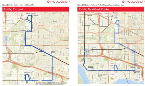 On Thursday DDOT released its 2017 Transit Development Plan, and amongst the torrent of words are proposals for a number of Circulator changes, including the long-discussed extension of the current Navy Yard route that would continue along M Street SW and the southern portion of Maine Avenue and up 7th Street SW to the L'Enfant Plaza Metro station, but would discontinue the portion of the route between Union Station and Eastern Market. (The double lines in the right-hand map are the "discontinued service" portions.)
* NEW ANC COMMISSIONERS: In local local local election results, ANC 6D07 (the seat left open by Meredith Fascett's retirement) has been won by Edward Daniels, while in 6D02 Anna Forgie clobbered incumbent Cara Lee Shockley.
Comments (54)
More posts:
albi, ANC News, Pedestrian/Cycling Issues, Restaurants/Nightlife, maxwell, meetings, Square 696 Residential, Traffic Issues, yardsparcelg, Bower Condos/Guild Apts/Yards
DDOT Unveils Planned Extension of Navy Yard Circulator to M St. SW, L'Enfant Plaza
Dec 15, 2017 9:50 AM
 On Thursday DDOT released its 2017 Transit Development Plan, and amongst the torrent of words are proposals for a number of Circulator changes, including the long-discussed extension of the current Navy Yard route that would continue along M Street SW and the southern portion of Maine Avenue and up 7th Street SW to the L'Enfant Plaza Metro station, but would discontinue the portion of the route between Union Station and Eastern Market. (The double lines in the right-hand map are the "discontinued service" portions.)
 There would also be year-round weekend service, from 7 am to 9 pm on Saturdays and Sundays.
Circulator service between Union Station, Barracks Row, and the Washington Navy Yard (the actual, living, breathing, functioning "Navy Yard") would be available on a reconfigured version of the Potomac Avenue-Skyland route (see page 52 of the report for a map).
The report also says that "a special standalone service plan will be developed to provide DC Circulator service to the new DC United Soccer Stadium before, during, and after games."
 I have been intending to write more substantively about a few of these things, but now in the interest of actually getting them posted, I'll go with abbreviated versions:
These changes aren't final--there is now a public comment period, through Jan. 19, 2018, and there will be a public hearing on Thursday, Jan. 4, 2018, from 7 to 9 pm at the Miracle Theatre at 535 8th St., SE.
But DDOT says that it expects that the changes would be implemented in April, 2018.
Comments (34)
Tuesday Tidbits: Short and Sweet
Nov 14, 2017 11:49 AM
 I have been intending to write more substantively about a few of these things, but now in the interest of actually getting them posted, I'll go with abbreviated versions:
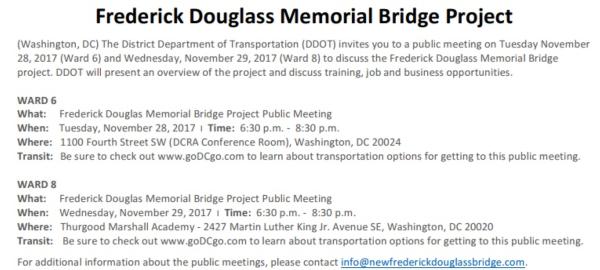
* DOUGLASS BRIDGE MEETING: DDOT is holding two public meetings to "discuss the current status" of the new Douglass Bridge project. There is one in Ward 6 on Tuesday, Nov. 28 from 6:30 to 8:30 pm at 1100 4th St., SW (DCRA conference room), and another in Ward 8 on Wednesday, Nov. 29 from 6:30 to 8:30 pm at the Thurgood Marshall Academy, 2427 Martin Luther King Jr. Ave., SE. See my project page and/or the official web site for details.
* DOUGLASS BRIDGE BLEATING: The Commission on Fine Arts says the new bridge design "lacks grace." (WBJ)
* 3RD STREET TWEAKING: Watch for the single travel lane on 3rd Street SE at Virginia Avenue to be moved off of the temporary deck and onto new pavement Any Minute Now. This is so the deck can be demolished and restoration work can then continue on both 3rd and Virginia. (CSX)
 In recent months (mostly during the time I was preoccupied) DDOT has been working on plans to reconfigure I Street SE between New Jersey and South Capitol to better handle the large amount of vehicle, bicycle, and pedestrian traffic on a road that once was sleepy but now most decidedly is not.
* BARRACKS EIS RELEASING: Remember those plans to build a new Marine Bachelor Enlisted Quarters, which ended up deciding that the new building would be built next to the existing building at 7th and L? There's actually some movement, with the final EIS expected to be released Any Minute Now, and the Record of Decision expected to follow. I'll write more when the EIS comes out, but in the meantime here's a newsletter from last month with the latest.
* ANC REP REPPING: Read more updates on neighborhood goings-on from ANC 6D07 commissioner Meredith Fascett.
* TASTEBUDS APPROVING: Ana, the restaurant at District Winery, gets good words from the Post's food critic. (WaPo)
Comments (11)
Public Meeting on I Street Bicycle and Ped Improvements
Nov 1, 2017 11:14 AM
 In recent months (mostly during the time I was preoccupied) DDOT has been working on plans to reconfigure I Street SE between New Jersey and South Capitol to better handle the large amount of vehicle, bicycle, and pedestrian traffic on a road that once was sleepy but now most decidedly is not.
This Satuday, Nov. 4, DDOT representatives are holding a public meeting on what is officially known as the I Street SE Pedestrian and Bicycle Safety Improvements Project. It's at 11 am, and instead of in a stuffy conference room, the meeting will be held on the south side of I Street SE at Half Street SE (so, dress appropriately!).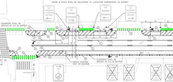 Up for discussion will be a final design for this four-block stretch, which (if I am reading the graphics right) calls for the shifting of bike traffic on the blocks between South Capitol and 1st into protected lanes along the curb, with the parking lanes then acting as buffer between bikes and the traffic lanes. Vehicle lanes will still be a single lane in each direction as well as a center turn lane. There will also be flexposts at some of the intersections to prevent cars from taking turns too sharply in a way that endangers pedestrians and cyclists.
 Up for discussion will be a final design for this four-block stretch, which (if I am reading the graphics right) calls for the shifting of bike traffic on the blocks between South Capitol and 1st into protected lanes along the curb, with the parking lanes then acting as buffer between bikes and the traffic lanes. Vehicle lanes will still be a single lane in each direction as well as a center turn lane. There will also be flexposts at some of the intersections to prevent cars from taking turns too sharply in a way that endangers pedestrians and cyclists.
At right is a portion of the section between Half and 1st (see what I mean about "deciphering"), but if you are willing to test your ability to read traffic engineering graphic design, you can see the entire layout here.
If you have feedback, wander on by the assembly at Half and I at Saturday at 11. You can probably even bring your dog.
Comments (21)
More posts:
Pedestrian/Cycling Issues, meetings, Traffic Issues
Neighborhood Emergency Preparedness Meeting Saturday, June 18
Jun 16, 2016 9:05 PM
On Saturday, June 18, there will be an Emergency Preparedness Meeting for residents to get training in what to do in the case of a train derailment or hazardous materials incident, a topic on the minds particularly of residents who live close to the Virginia Avenue Tunnel.
Lead by DC HSEMA director Chris Geldart, fire chief Gregory Dean, and Department of Energy and the Environment director Tommy Wells, the session will provide training "about safety during a derailment involving hazardous materials; sheltering-in-place vs. evacuating; emergency vehicle access; and emergency communications."
The meeting is at 10 am at 200 I St., SE. Contact ANC 6D07 commissioner Meredith Fascett for more information.
Comments (0)
More posts:
CSX/Virginia Ave. Tunnel, meetings
Tuesday Tidbits: The Latest from Seattle on the Anacostia
May 17, 2016 11:19 AM
The rain has sapped my energy, plus I'm in just-back-from-vacation-mode (a short trip to Vegas, which means I'm currently wearing a barrel and standing on a street corner begging for money), but I'm trying to bring you tidbits anyway. * 909 HALF: The Project Of Which Its Developers Don't Speak has apparently topped out, according to the architects, who I hope won't now be canned for daring to publicly refer to the 380-unit apartment building under construction at Half and I. They also posted a color version of the one rendering we've seen, showing the view up Half Street from south of K. There had been an additional post from the architects saying 909 Half would be opening in December, but that's now gone, probably because getting to completion seven months from now would be, shall we say, optimistic.
 * 909 HALF: The Project Of Which Its Developers Don't Speak has apparently topped out, according to the architects, who I hope won't now be canned for daring to publicly refer to the 380-unit apartment building under construction at Half and I. They also posted a color version of the one rendering we've seen, showing the view up Half Street from south of K. There had been an additional post from the architects saying 909 Half would be opening in December, but that's now gone, probably because getting to completion seven months from now would be, shall we say, optimistic.
* NEW WEB SITES: Actual web sites are now up for both F1rst and ORE 82. (The former had just a placeholder and the latter's URL didn't actually work a few weeks ago when the fence signage went up.)
* JOY EVANS: ANC 6D Commissioner Meredith Fascett has an update on last week's meeting on Joy Evans Park, with a deadline of today (oops) for any comments you might have.
And, a few meetings this week to mention:
* COFFEE WITH CHUCK: The Virginia Avenue Tunnel project has hit the one-year mark this month (only 30 more months to go!). The monthly Coffee with Chuck meeting is on Wednesday, May 18, from 8 to 9 am at the CSX Community Office trailer at 861 New Jersey Ave., SE. RSVP here if you plan to attend.
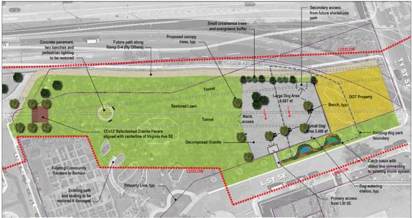
 Via ANC 6D07 commissioner Meredith Fascett, there is going to be a public meeting on Tuesday, May 10 about the plans for Joy Evans Park, the public space a lot of people may not even know about just to the east of Van Ness Elementary School between L and M Streets, SE.
* PUBLIC SAFETY: The monthly meeting of PSA 106 is Wednesday, May 18 at 7 pm at 200 I St. SE. MPD holds these meetings to address any public safety-related questions and concerns from the neighborhood.
* BIKE TO WORK: I'm too scared to look at the weather forecast, but Friday, May 20 is Bike to Work Day, and once again Canal Park is one of the pit stops.
Comments (1)
May 10 Public Meeting on Plans for Joy Evans Park
May 1, 2016 8:20 PM
 Via ANC 6D07 commissioner Meredith Fascett, there is going to be a public meeting on Tuesday, May 10 about the plans for Joy Evans Park, the public space a lot of people may not even know about just to the east of Van Ness Elementary School between L and M Streets, SE.
The park's stewardship is a typical DC mishmash, with the land owned by the National Park Service and management handled by DC's Department of Parks and Recreation, but with a memorandum of understanding now in place to allow DC Public Schools to use a portion of the land for "recreation and educational space" for Van Ness.
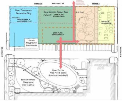
An initial notion of how the park space could be laid out is above, but there are many questions and notions still to be determined, as laid out in Meredith's Facebook post. Apparently DCPS has money this year to build a playground, an outdoor classroom and garden, and an "open turf area" for free play. But DPR does not have any funding for Joy Evans, and so the future remains unclear in terms of the renovation of the historic Lincoln Playground Building, the possible demolition of the Lincoln Capper pool and the adjacent "therapeutic recreation building" (what, you didn't know there is a therapeutic recreation building there?), and perhaps future playing fields and splash pads.
The May 10 meeting is at Van Ness at 6:30 pm. You can also contact Meredith with comments, concerns, questions, remarks, observations, opinions, notes, or feedback.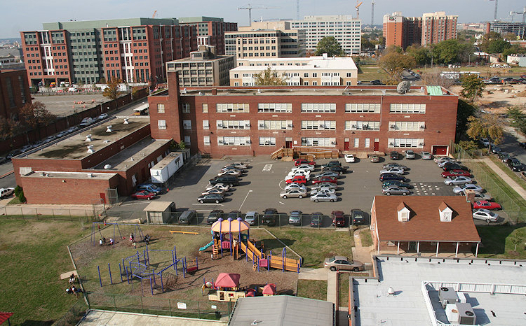 The photo at right was taken in 2007 from the roof of the old Capper Seniors building in its final days. You can see the general footprint of the Joy Evans Park along the lower part of the photo, with the Lincoln Capper pool and therapeutic recreation building cut off and the Lincoln Playground Building visible at lower right, with the grassy areas at left where the DCPS Phase 1 plans are to be built.
 The photo at right was taken in 2007 from the roof of the old Capper Seniors building in its final days. You can see the general footprint of the Joy Evans Park along the lower part of the photo, with the Lincoln Capper pool and therapeutic recreation building cut off and the Lincoln Playground Building visible at lower right, with the grassy areas at left where the DCPS Phase 1 plans are to be built.
 (Maybe I can get up on the roof of the Bixby at some point to take a current version, especially given the changes at Van Ness, including the new playground on the footprint of the parking lot that I can't believe I don't have even the most cursory photo of. I think I'm a-skeered of pointing my camera through a fence at an active playground and being promptly hauled off.)
Also, note that at the top of the site plan is "6th Street SE" -- this is the planned new block of 6th between L and M, running between this park area and the Bixby.
And, speaking of changes at Van Ness, I have been remiss in not mentioning the very visible construction along M Street of the new second floor above the gymnasium. But I took a picture!
Comments (10)
More posts:
joyevans, meetings, Van Ness Elementary
Tuesday Tidbits: Attempted Carjacking, Meeting Lineup, and More
Apr 19, 2016 10:32 AM
* ATTEMPTED CARJACKING: On Monday night there was an attempted armed carjacking in the 100 block of K Street, SE. According to the MPD 1-D mailing list: "The Complainant stated he was approached while standing in the doorway of his vehicle when the suspect struck him in the right side of face and eye with an unknown object. The suspect jumped in the complainant's car and demanded the keys to the car; however, the complainant fled with his keys and no property was obtained. The suspect fled and has not been arrested yet."
* PSA 106 PUBLIC SAFETY MEETING: The monthly meeting for Police Service Area 106 (which covers Near Southeast/Navy Yard/#NeCaBaRY) is scheduled for Wednesday, April 20, at 7 pm, at 200 I St. SE (government ID required to enter the building). MPD hosts these monthly meetings to address questions and concerns from the public about issues of safety in the community.
* DC WATER TOWN HALL: Sorry for the last-minute notice, but there is a DC Water Ward 6 Town Hall Meeting tonight (Tuesday, April 19) at 6:30 pm at Tyler Elementary School, 1001 G St., SE. DC Water Grand Poobah George Hawkins and Ward 6 councilmember Charles Allen are co-hosting the meeting to talk about current projects, billing rates, and more.
* WARD 6 BUDGET TOWN HALL: Speaking of town halls, Charles Allen is also hosting one on Thursday, April 21 on DC's proposed budget for FY17. It's at 6:30 pm at 645 H St., NE. "Before the Council votes on the budget, hear from Councilmember Allen on what's in it for Ward 6, where he's focused in the budget debate, and what comes next in budget decisions."
 UPDATE, NOV. 9: This meeting is now going to be on Nov. 17, still at 6:30 pm at 200 I St., SE. It was rescheduled from its original date that turned out to conflict with a public safety meeting
* TWO-WAY THIRD: CSX says that two-way traffic could return to 3rd Street north of I perhaps as early as Friday, April 22. Watch also in the next day or so for a shift in the current one-way flow onto the new bridge deck.
Comments (0)
More posts:
crime, CSX/Virginia Ave. Tunnel, meetings
Nov. 17 New Date for Public Meeting on Capper Square 767 Plans
Nov 9, 2015 8:31 PM
 UPDATE, NOV. 9: This meeting is now going to be on Nov. 17, still at 6:30 pm at 200 I St., SE. It was rescheduled from its original date that turned out to conflict with a public safety meeting
Original post:
There's not much detail at this point, but a public meeting has been scheduled on Oct. 27 at 6:30 pm at 200 I Street to discuss the DC Housing Authority's plans for the block known as Square 767, bounded by 2nd Place and 3rd, I, and K Streets SE.
This block, part of the Capper/Carrollsburg Hope VI redevelopment footprint, is the location where DCHA is looking to sell a portion of the land so that an as-yet unnamed developer can build a market-rate condo building. Such a plan would seem to mean that the necessary affordable rental units on that block would be confined to whatever non-condo project is also built on that block, a notion has had neighbors expressing much concern since it was first revealed nearly two years ago.
There's no agenda or materials yet released, so look for a more detailed post once DCHA makes those items available.
Comments (0)
Update: Community Meetings on Public Safety This Week
Oct 25, 2015 5:12 PM
(See below for a more complete list of community meetings this week)
In response to the recent crimes around Ward 6--including three armed robberies* in recent days in Near Southeast--council member Charles Allen has scheduled a community meeting on public safety on Tuesday, Oct. 27, at 7 pm at the Friendship Public Charter School at 1345 Potomac Ave., SE.
Allen has invited police chief Cathy Lanier and 1D Commander Jeff Brown to "outline their plans and response" to handling the increased crime as well as to answer questions from residents.
According to his web site, Allen has been working with Lanier and Brown "to add more resources, manpower, and overtime to the neighborhoods," and has also been "looking at the long-term problem and solutions, working with Council colleagues on how we move forward to make needed legislative changes for our communities and our city."
While crime has been spiking around Ward 6 in recent months, the two armed robberies south of the freeway Wednesday evening (part of a string of five armed robberies within 30 or so minutes) brought an increase in concern from Near Southeast residents, even with the news that possible suspects were arrested the following evening after a chase by DC police into Maryland.
In addition, a third armed* robbery happened on Friday night at around 9:20 pm in the 900 block of New Jersey Ave., SE. According to the police report (and also described by the Post), a citizen was approached and robbed at gunpoint, but an off-duty MPD officer saw it happen and called for assistance--and as police saw the suspect leaving the area, the "victim of the robbery then suddenly reappeared and tackled the suspect." (Was it one of you guys?)
*However, in this case it was found out that the weapon used in the robbery was an "imitation pistol." The suspect was still arrested, and the victim's property was recovered.
Also, on Saturday night, there was a robbery at 4th and K SE.
PS: It's a shame that the public safety meeting is on the same evening as the Capper Square 767 public meeting, but These Things Happen. NOTE: This Capper meeting is going to be rescheduled.
(I've been out of town for a few days, so apologies for the slow news on the third robbery.)
UPDATE II: Per ANC commissioner Meredith Fascett, here is the full lineup of community meetings this week, some of which are specifically in regards to public safety, and others which can easily accommodate the subject. Note also that the Capper/Square 767 meeting that was also scheduled for Tuesday Oct. 27 is being postponed, with a new date to be announced.
* OCT. 26, MAYOR BOWSER: Mayor Bowser will speak and take questions tonight (Monday, Oct. 26) at 7 pm at the monthly Southwest Neighborhood Assembly (SWNA) meeting at Arena Stage, 101 6th St. SW.
* OCT. 27, ANC 6D07 OFFICE HOURS: Meet with Meredith Fascett at 10 am at Lot 38 Espresso.
* OCT. 27, MAYOR'S OFFICE: The Mayor's Office of Community Relations (MOCRS) is having office hours from 3 to 6:30 pm at Mt. Moriah Baptist Church, 1636 E. Capitol St., NE.
* OCT. 27, CM ALLEN MEETING: As announced at the top of this post.
* OCT. 31 PSA MEETING: The monthly meeting of the neighborhood's Police Service Area, PSA 106, will be on Saturday at 10 am at 900 5th St. SE (the Capper Senior Building). MPD representatives will have information on the recent incidents in the neighborhood.
 I did not attend last week's meeting on the plans for Virginia Avenue's streetscape once construction on the tunnel is completed, but detailed notes taken by DDOT have been posted. And there are some items that caught my eye:
Tidbits of Note from the Virginia Ave. Streetscape Meeting
Oct 7, 2015 12:16 PM
 I did not attend last week's meeting on the plans for Virginia Avenue's streetscape once construction on the tunnel is completed, but detailed notes taken by DDOT have been posted. And there are some items that caught my eye:
* TREES: It's reported that 176 trees have been cut down as part of the tunnel construction, and that there will be approximately 305 new trees planted once the work is done. DDOT's preferred species include oaks, elms, and honey locust, and the planting scheme is such that it is expected to provide 50 percent "canopy coverage" after 20 years, 10 percentage points higher than the required minimum.
* PARKING: "The design team recognizes that parking is a critical issue for the neighborhood, and will ensure that the number of parking spaces in the neighborhood remains the same. DDOT will explore the possibility of providing additional parking."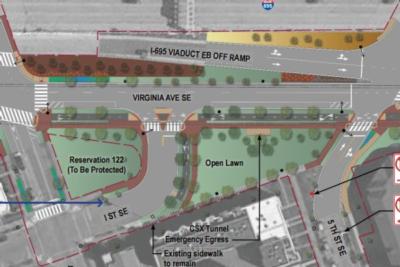 * I STREET: Plans to have the 400 block of I Street end in a stub east of the church have apparently been shelved: "Based on community feedback, the connection of I Street to the 400 block of Virginia Avenue has been restored." As seen in this revised image.
 * I STREET: Plans to have the 400 block of I Street end in a stub east of the church have apparently been shelved: "Based on community feedback, the connection of I Street to the 400 block of Virginia Avenue has been restored." As seen in this revised image.
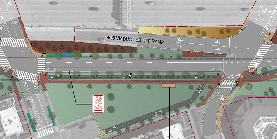
* MORE VIRGINIA!: My personal favorite out of all of this: "The Architect of the Capitol will complete their construction project in 2018, and has indicated willingness to reopen Virginia Avenue between South Capitol Street and 2nd Street SE." This would also "enhance" connections to Garfield Park, allowing for passage in locations other than just the skate park-area under the freeway.
* TWO-WAY: Once construction is over, the 800 blocks of both Virginia Avenue and L Street SE will be converted to two-way traffic.
* LIGHTING: Replacement streetlights will be LEDs, which emit a whiter light than the current streetlights. There are apparently LED streetlights now installed on 1st Street near the ballpark as a test case for the city, and the "fixtures specified for Virginia Avenue will be similar to the first series of lights on the right hand side of First Street moving away from M Street."
* VIRGINIA AVE. PARK: The final post-construction design of Virginia Avenue Park is actually the responsibility of the Department of Parks and Recreation, and there will be a "design charrette" to discuss the park's future on Oct. 15 at 7 pm at the Hill Center, 921 Pennsylvania Ave., SE.
Go ahead and read the notes for more details (and you can even see all the comment sheets handed in by the attendees). And the most recent designs for the streetscapes are here, plus you can check out my look at the initial designs.
Comments (9)
More posts:
CSX/Virginia Ave. Tunnel, meetings, Traffic Issues
A Very Multimodal Lineup of Upcoming Public Meetings
Sep 23, 2015 11:29 AM
Some transportation-related meetings are on the calendar for next week that may be of interest to neighborhood folks: * DC STATE RAIL PLAN OPEN HOUSE: The project to create an official "State Rail Plan" (ahem) for DC is kicking off, and DDOT is holding an open house on Monday, Sept. 28 to "introduce the plan to the community." This rail plan is a requirement for any state (again, ahem) wishing to be eligible for grants and other federal financial assistance, and is going to focus on "passenger and freight rail infrastructure shared by CSX, VRE, MARC, Amtrak, and Norfolk Southern." The intent is to have a completed plan that will provide a high-level strategic framework, goals, and objectives to leverage the District’s rail network for continuing economic competitiveness and quality-of-life investments while also addressing ongoing concerns about rail safety and oversight."
 * DC STATE RAIL PLAN OPEN HOUSE: The project to create an official "State Rail Plan" (ahem) for DC is kicking off, and DDOT is holding an open house on Monday, Sept. 28 to "introduce the plan to the community." This rail plan is a requirement for any state (again, ahem) wishing to be eligible for grants and other federal financial assistance, and is going to focus on "passenger and freight rail infrastructure shared by CSX, VRE, MARC, Amtrak, and Norfolk Southern." The intent is to have a completed plan that will provide a high-level strategic framework, goals, and objectives to leverage the District’s rail network for continuing economic competitiveness and quality-of-life investments while also addressing ongoing concerns about rail safety and oversight."
The open house will run from 5:30 pm to 7:30 pm at Friendship Public Charter School-Chamberlain Campus, 1345 Potomac Avenue, SE. This start time is 30 minutes earlier than originally announced, because....: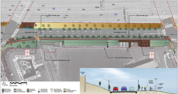 * VIRGINIA AVE. STREETSCAPE RESTORATION REVIEW MEETING: Also on Monday, Sept. 28, beginning at 6:30 pm at 200 I St. SE, a joint meeting by DDOT and ANCs 6B and 6D will go over CSX's draft plans for rebuilding Virginia Avenue once construction is complete on the Virginia Avenue Tunnel. The first 30 minutes will be an open house, and then presentations and discussions will begin at 7 pm. There will also be a special public meeting of DDOT's Public Space Committee about the plans on Nov. 12.
 * VIRGINIA AVE. STREETSCAPE RESTORATION REVIEW MEETING: Also on Monday, Sept. 28, beginning at 6:30 pm at 200 I St. SE, a joint meeting by DDOT and ANCs 6B and 6D will go over CSX's draft plans for rebuilding Virginia Avenue once construction is complete on the Virginia Avenue Tunnel. The first 30 minutes will be an open house, and then presentations and discussions will begin at 7 pm. There will also be a special public meeting of DDOT's Public Space Committee about the plans on Nov. 12.
(And then maybe for Christmas we can pitch in and get DDOT a group calendar, to perhaps avoid in the future scheduling two meetings with a very similar audience on the same night at nearly the same time in not-particularly-adjoining locations.)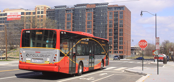 * CIRCULATOR STOP CONSOLIDATION MEETING: On Wednesday, Sept. 30, DDOT is having a public meeting to talk about possibly consolidating some stops on the Union Station-Navy Yard line "to improve on-time performance and reliability." The only south-of-the-freeway stops on the potential chopping block are the ones at 4th and M SE in both directions, with the 6th and M stops being the closet ones to use instead. (The announcement gives the full lineup.) The meeting is from 6pm to 8pm at the Southeast Neighborhood Library, 403 7th Street SE.
 It's hard to believe that in a few months the first batch of students will return to Van Ness Elementary, for the first time since 2006. With initial renovations and plans for the 2015-16 school year underway, the school is hosting a "Showcase" community meeting on Wednesday, June 17, from 6 to 8 pm.
 * CIRCULATOR STOP CONSOLIDATION MEETING: On Wednesday, Sept. 30, DDOT is having a public meeting to talk about possibly consolidating some stops on the Union Station-Navy Yard line "to improve on-time performance and reliability." The only south-of-the-freeway stops on the potential chopping block are the ones at 4th and M SE in both directions, with the 6th and M stops being the closet ones to use instead. (The announcement gives the full lineup.) The meeting is from 6pm to 8pm at the Southeast Neighborhood Library, 403 7th Street SE.
* CSX'S "COFFEE WITH CHUCK": If you want to go for the 72-hour quadfecta of transportation sessions, there's also the next edition of CSX's monthly meetings with the community to discuss the Virginia Avenue Tunnel project, on Wednesday, Sept. 30 from 8 to 9 am at the Courtyard by Marriott at 140 L St. SE. Items that might be up for discussion include the coming closure of the 300 block of Virginia Ave. (in "early October") and also the temporary closures of 4th Street SE from just north of the I-695 underpass down to I Street from 9:30 am to 3:30 pm this week and probably into next week.
Comments (6)
More posts:
Pedestrian/Cycling Issues, circulator, CSX/Virginia Ave. Tunnel, meetings, Traffic Issues
Van Ness Elementary School 'Showcase' on June 17
Jun 15, 2015 5:18 PM
 It's hard to believe that in a few months the first batch of students will return to Van Ness Elementary, for the first time since 2006. With initial renovations and plans for the 2015-16 school year underway, the school is hosting a "Showcase" community meeting on Wednesday, June 17, from 6 to 8 pm.
Note that it is at 200 I St., SE, not at the school itself.
 As preparations ramp up to reopen Van Ness Elementary School this fall, DCPS is holding a "Design Slam" on Wednesday, Jan. 28, at 6 pm in the school's auditorium at 5th and L streets, SE.
The Head of School, Cynthia Robinson-Rivers, will be there, as will the initial teachers. The interior and exterior renovation plans will also be on display, as will the new playground designs.
The school is opening with PK-3, PK-4, and kindergarten classes, with plans to add one grade each year until 5th grade is reached.
Comments (4)
More posts:
meetings, Van Ness Elementary
Van Ness School 'Design Slam' Jan. 28; Fundraiser Feb. 17
Jan 27, 2015 6:38 PM
 As preparations ramp up to reopen Van Ness Elementary School this fall, DCPS is holding a "Design Slam" on Wednesday, Jan. 28, at 6 pm in the school's auditorium at 5th and L streets, SE.
As the flyer says, the goal of this session "is to listen to your ideas in order to develop a design that celebrates the best characteristics of the Van Ness community," looking toward what elements of the neighborhood's history and its riverfront location should be incorporated and "celebrated" in the design.
Architectural firm Quinn Evans is working on the project, and the bidding process for the construction itself will happen this spring.
 If you are looking for some light Christmas reading, you can sit down by the fireplace with all 335 pages (plus appendices!) of the newest revision to the plans for reconfiguring much of South Capitol Street, including the construction of a new Frederick Douglass Bridge.
Free childcare and food at the Slam will be provided by the Van Ness Parent Group.
And while it's still a couple of weeks away, this is a good time to also mention that the Near Southeast Community Partners group is hosting a Van Ness Elementary School Fundraiser on Feb. 17 at Nando's Peri-Peri. From 6 pm to 10 pm, the restaurant will donate 40 percent of its receipts from all sales made to people with the fundraiser flyer in hand. [insert "Winner winner chicken dinner reference here]
Comments (1)
More posts:
meetings, Van Ness Elementary
Latest South Capitol Corridor Draft Plan Released; Meeting Jan. 22
Dec 22, 2014 2:33 PM
 If you are looking for some light Christmas reading, you can sit down by the fireplace with all 335 pages (plus appendices!) of the newest revision to the plans for reconfiguring much of South Capitol Street, including the construction of a new Frederick Douglass Bridge.
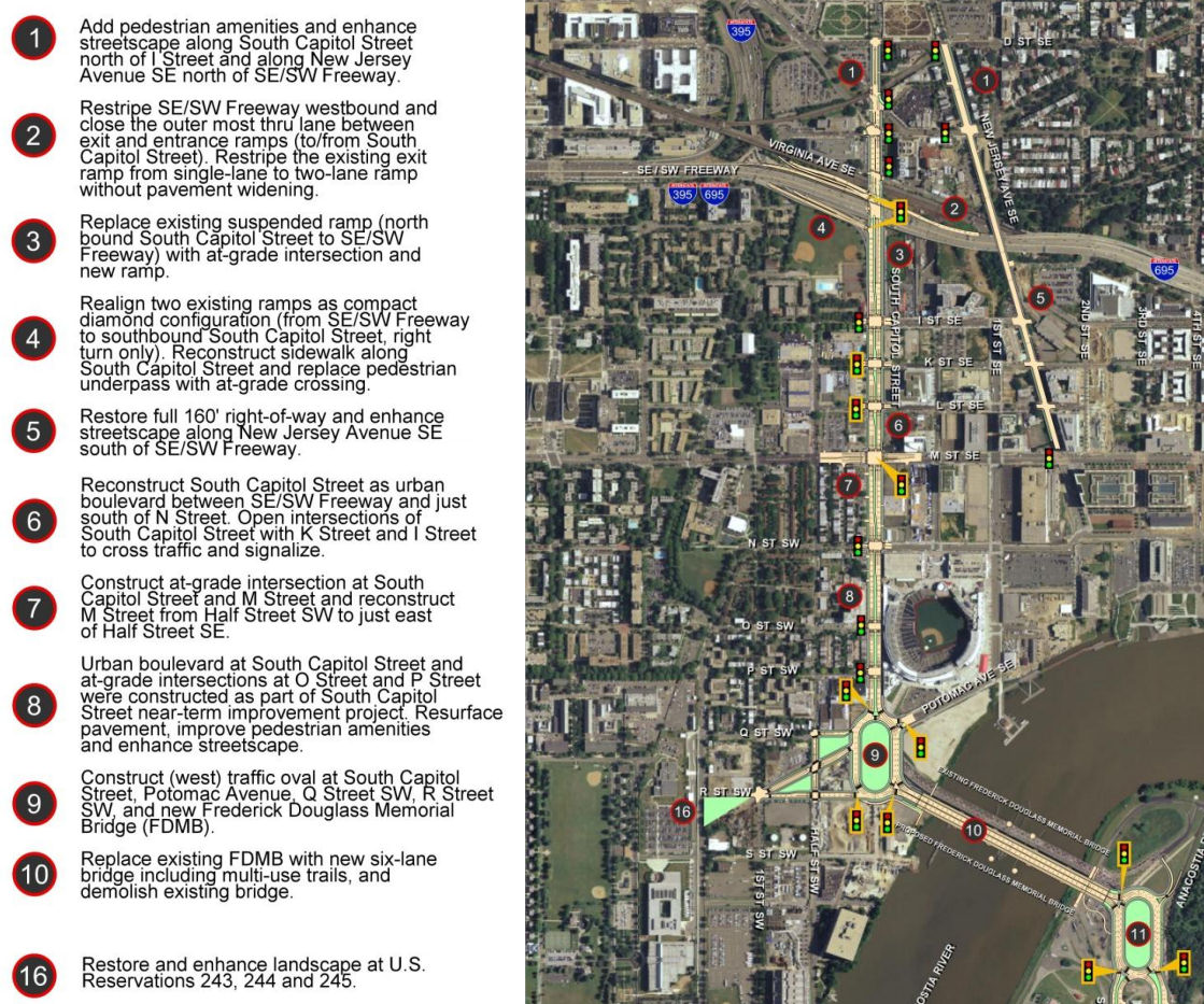
This document, technically known as the Supplemental Draft Environmental Impact Statement (SDEIS), describes the new "revised preferred alternative" (RPA) design that tweaks the original preferred alternative in the Final EIS released back in 2011.
The bullet points for what the project plans are north/west of the Anacostia River are in the graphic at right (click to enlarge). The changes in this new RPA include:
* Changing the design of the bridge from a moveable span to a fixed-span bridge, which would save approximately $140 million in construction costs;
* Shifting the orientation of the new Douglass Bridge to an alignment parallel to the existing bridge, 30 feet down river, which avoids the need and lengthy process to acquire some land from Joint Base Anacostia-Bolling as well as a number of expensive relocation and reconstruction issues that a new alignment avoids (see page 2-91 of the SDEIS for details);
* A slight reduction of the size of the traffic oval on the western side (at Potomac Avenue):
* Replacing the previously designed circle on the eastern approach with an oval, located entirely in the DDOT right-of-way;
* And several other changes on the east side of the project that I will leave to others to discuss in detail. (See page ES-6 of the SDEIS.)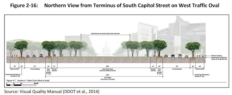 The initial design of the ovals and of the bridge itself were met with some consternation during this revision process. The SDEIS notes that in response to these concerns, DDOT has created a "Visual Quality Manual" for the project, which identifies design goals that are to "reflect the vision of providing a grand urban boulevard, which will be a gateway into the nation's capital, an iconic symbol of the District's aspirations in the 21st century, and a catalyst to revitalize local neighborhoods and the Anacostia Waterfront." (page 2-26).
 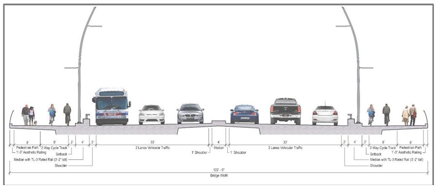 As for the bridge itself, the version in this RPA will support three travel lanes in each direction, along with 18 feet of bicycle and pedestrian paths on *both* sides of the bridge--an 8-foot lane for pedestrians and a 10-foot birdirectional bike path. (Enlarge the image at right to see that I'm not lying about the bike/ped stuff.)
 The initial design of the ovals and of the bridge itself were met with some consternation during this revision process. The SDEIS notes that in response to these concerns, DDOT has created a "Visual Quality Manual" for the project, which identifies design goals that are to "reflect the vision of providing a grand urban boulevard, which will be a gateway into the nation's capital, an iconic symbol of the District's aspirations in the 21st century, and a catalyst to revitalize local neighborhoods and the Anacostia Waterfront." (page 2-26).
  As for the bridge itself, the version in this RPA will support three travel lanes in each direction, along with 18 feet of bicycle and pedestrian paths on *both* sides of the bridge--an 8-foot lane for pedestrians and a 10-foot birdirectional bike path. (Enlarge the image at right to see that I'm not lying about the bike/ped stuff.)
And the design of the bridge is to "make its primary aesthetic impact through its position (alignment), and the shape and sizes of its structural elements" and is to " aesthetically appear to be part of a continuous urban corridor." This includes the avoidance of "using elements, solely for aesthetic effect, which do not contribute to the support of the bridge." (page 2-28)
Plans for the reconfiguration of South Capitol Street as a "grand urban boulevard" have all along called for changing the intersection of South Capitol and M streets to an "at-grade intersection" (page 4-79), which would also mean that K and L would have signalized four-way intersections with South Capitol, unlike today. The wide median seen south of N would be established on the north end of the street as well, now all the way to D Street SE in the RPA. Also changing in this new plan are a few new left-turn options at I Street SE/SW and L Street SE. Revisions have also been made to the ramps from South Capitol Street to I-395 and I-695, but the basics from the original plans remain, most notably the demolition of the existing suspended ramp from northbound South Capitol to the SE/SW Freeway.
 Revisions have also been made to the ramps from South Capitol Street to I-395 and I-695, but the basics from the original plans remain, most notably the demolition of the existing suspended ramp from northbound South Capitol to the SE/SW Freeway.
Even with the revisions made to cut the costs of the new Douglass Bridge, this isn't a cheap project. The five phases together are anticipated to cost over $1 billion, with Segment 1, including the new bridge and traffic ovals, estimated at $480 million. The "grand boulevard"-izing of South Capitol Street is estimated at $153 million, and planned streetscape improvements to New Jersey Avenue between D and M streets SE at $42 million, plus another $358 million in east-of-the-river improvements (page 2-11).
 A community meeting is on tap for Thursday (tomorrow), Dec. 11, to discuss the future Southeast Blvd., specifically the ideas emerging from the neighborhood study currently being spearheaded by ANC 6B, the Office of Planning, and DDOT.
Worn out yet? I sure am! (I've mostly lost track of how much of this is truly even "new" news at this point.) But perhaps you can regain your strength by Jan. 22, 2015, when the public meeting on this SDEIS will be held from 6:30 to 8:30 pm at Matthews Memorial Baptist Church Fellowship Hall, 2616 Martin Luther King Ave., SE. The public comment period is running until Feb. 2. DDOT is also still amidst the design/build proposal process, with proposals expected sometime in the spring.
The SouthCapitolEIS.com web site is now focused mainly on this SDEIS, of which clearly I've just scratched the surface; you can slog through my piles of posts on all of this over the years for the historical rundown.
UPDATE: Here's the WashCycle take on the latest plans, from a bike/ped perspective.
Comments (5)
More posts:
Pedestrian/Cycling Issues, meetings, M Street, South Capitol St., Douglass Bridge, Traffic Issues
Southeast Blvd. Community Meeting on Thursday, Dec. 11
Dec 10, 2014 9:24 AM
 A community meeting is on tap for Thursday (tomorrow), Dec. 11, to discuss the future Southeast Blvd., specifically the ideas emerging from the neighborhood study currently being spearheaded by ANC 6B, the Office of Planning, and DDOT.
The meeting is from 7 to 9 pm at Friendship Chamberlain Elementary School, 1345 Potomac Ave., SE, across from the Jenkins Row Harris Teeter.
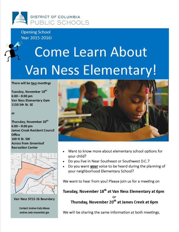 As part of the path toward the planned reopening next fall of Van Ness Elementary School at 5th and M streets, SE, DCPS has scheduled public meetings on Nov. 18 and Nov. 20 for residents in Near Southeast and Southwest to learn about the plans for the school, and to be able to provide feedback on those plans.
Councilmember Tommy Wells will be there, and will be part of the discussion on how to best integrate into the neighborhood this road that will run from Barney Circle to the new intersection at 11th Street, SE, along the path of the old sunken portion of the Southeast Freeway.
A "temporary" version of the road is opening in early 2015, and residents have been concerned both about this becoming the de facto new version of the road, a feeling that came on the heels of the original new designs put forth by DDOT, that were basically replacing an old freeway with a new freeway, albeit it one that has a stoplight at 11th Street rather than just a free-and-clear approach to the Southeast Freeway. After those designs were released, with a push from Wells, the Office of Planning stepped in to help shepherd a neighborhood study--initial design concepts were unveiled back in August, and this week's meeting is to continue the process of refining the possibilities.
(And I am well aware that I have completely failed at keeping up with photographs of that area of 11th and of the work underway on the temporary road. All of the construction there, and the futzing with the traffic flow configuration of 11th Street while work continues around it, have made me very cranky about going over there to take pictures. Maybe this will finally spur me.)
Comments (4)
More posts:
meetings, Southeast Blvd., Traffic Issues
Public Meetings on Van Ness Elementary School Reopening
Nov 12, 2014 12:32 PM
 As part of the path toward the planned reopening next fall of Van Ness Elementary School at 5th and M streets, SE, DCPS has scheduled public meetings on Nov. 18 and Nov. 20 for residents in Near Southeast and Southwest to learn about the plans for the school, and to be able to provide feedback on those plans.
These sessions follow a meeting back in September between parents' groups and Dr. Nathaniel Beers, DCPS's head of specialized instruction, in which the parents were displeased with some of the information coming from the school system, specifically the plans to not have a principal in place during the planning process, and also DCPS's intent to open the school with only two PK-3 and two PK-4 classrooms, and no kindergarten.
A subsequent communication from Dr. Beers to the Van Ness Parents Group indicated, however, that an "Executive Director" will be put in place in early 2015, a person "whose primary responsibilities are to functioning as the leader of Van Ness, including engaging deeply with future parents and community members and actively recruiting students to ensure Van Ness opens fully enrolled."
In addition, the plea from parents for kindergarten offerings in the initial 2015-16 school year was not fully ignored, with DCPS agreeing to review community analysis data again before making a final decision. This has the parents' group working hard to find kindergarten-age children who could be sent to Van Ness in 2015.
These meetings should also have some information on the School Improvement Team process for the school going forward.
 I'm not sure how many people made this afternoon's meeting on the SE/SW Transportation Improvement Study (I sure didn't thanks to that 4 pm start time), but apparently there is a web site devoted to the project, and the meeting materials are posted there: seswdc.com.
The meeting schedule:
* Tuesday, Nov. 18, from 6 to 8 pm, at Van Ness Elementary; and
* Thursday, Nov. 20, from 6 to 8 pm at the James Creek Resident Council Office, 100 N St. SW.
Comments (0)
More posts:
meetings, Van Ness Elementary
Meeting Materials from SE/SW Transportation Improvement Study Meeting
Oct 22, 2014 8:33 PM
 I'm not sure how many people made this afternoon's meeting on the SE/SW Transportation Improvement Study (I sure didn't thanks to that 4 pm start time), but apparently there is a web site devoted to the project, and the meeting materials are posted there: seswdc.com.
This study is actually an Environmental Assessment, meaning there are very specific structures and steps that DDOT will be following.
Its stated purpose is "to develop a premium transit system that improves transportation capacity, connectivity, mobility, and safety through an integrated, multimodal transportation corridor" across Near Southeast, Southwest, and the Anacostia Historic District.
Also, the study is to address "east-west transportation needs between the Southeast and Southwest Washington communities of Anacostia and the Waterfront." One tidbit in the materials that may be news to people: If streetcars are chosen as the area's "premium transit mode," there will be a need for storage and/or maintenance, and so this Environmental Assessment "will review and analyze potential sites for a Streetcar facility."
 From DDOT: On Wednesday, Oct. 22, DDOT and the Federal Highway Administration will be holding a public meeting to discuss the Southeast/Southwest Transportation Improvement Study and Environmental Assessment, which is actually now a formal NEPA study (hence the presence of FHWA).
 One tidbit in the materials that may be news to people: If streetcars are chosen as the area's "premium transit mode," there will be a need for storage and/or maintenance, and so this Environmental Assessment "will review and analyze potential sites for a Streetcar facility."
 Eight potential sites meeting the initial minimum requirements have been identified: three near M Street, SW, three at Buzzard Point, and two along 7th Street, SE, including, believe it or not, the Blue Castle, aka the Navy Yard Car Barn, where streetcars were stored and maintained during the many years they ran through the city before being shut down in the early 1960s.
A second public meeting is expected in early 2015, with the draft Environmental Assessment and associated public hearing in spring and the final document late in the year.
(Thanks to Josh Hart for the heads up about the web site, and no thanks to DDOT, who didn't mention it in their releases about the meeting. BAH!)
Comments (14)
More posts:
Pedestrian/Cycling Issues, meetings, Traffic Issues
Public Meeting Wednesday on SE/SW Transportation Study
Oct 21, 2014 11:39 AM
 From DDOT: On Wednesday, Oct. 22, DDOT and the Federal Highway Administration will be holding a public meeting to discuss the Southeast/Southwest Transportation Improvement Study and Environmental Assessment, which is actually now a formal NEPA study (hence the presence of FHWA).
 Officially, "The purpose of the study is to develop a premium transit system that improves transportation capacity, connectivity, mobility, and safety."
 The second public meeting about the Virginia Avenue Tunnel Final Environmental Impact Statement has now been scheduled for 6:30 pm on Thursday, July 31, at the Capitol Skyline hotel at South Capitol and I streets, SW.
This is an off-shoot of the first M Street SE/SW study from 2011 and 2012 as well as the subsequent Special Events transportation study that was completed earlier this year. In other words, the study after the study after the study.
The meeting will be held at at Van Ness Elementary at 4 pm (! - I asked if that was a typo, and was told no). DDOT's announcement of the meeting says that "the public will be provided an opportunity to discuss the transportation issues and potential solutions that will be addressed in the study."
Comments (5)
More posts:
meetings, Traffic Issues
Next Virginia Avenue Tunnel Meeting July 31; Another Video
Jul 16, 2014 9:02 AM
 The second public meeting about the Virginia Avenue Tunnel Final Environmental Impact Statement has now been scheduled for 6:30 pm on Thursday, July 31, at the Capitol Skyline hotel at South Capitol and I streets, SW.
The release from the tunnel folks says that this meeting "will include a presentation responsive to input by citizens from the public meeting held on July 1, 2014 with a question and answer period focused on the July 1 input."
This is the additional meeting sought by DC delegate Eleanor Holmes Norton, along with the extension of the comment period from 30 to 60 days.
The official web site has the presentation and boards from the July 1 meeting.
 A gentle reminder that the public meeting to discuss the Final Environmental Impact Statement for the Virginia Avenue Tunnel is tonight (July 1) at 6:30 pm at the Capitol Skyline Hotel at South Capitol and I Streets, SW.
 At a public meeting on Wednesday night, the team working with the DC Housing Authority unveiled what programs the consultants will be recommending be offered at the Capper community center, a list that grew out of the recent survey about residents' wishes.
I already posted the video animation released to show how the construction would go, and now I see this additional video showing the completed east and west portals (entrances) to the tunnel, along with how Virginia Avenue is expected to look after construction is finished.
Comments (4)
More posts:
CSX/Virginia Ave. Tunnel, meetings
Reminder: Public Meeting on Virginia Avenue Tunnel EIS
Jul 1, 2014 12:05 AM
 A gentle reminder that the public meeting to discuss the Final Environmental Impact Statement for the Virginia Avenue Tunnel is tonight (July 1) at 6:30 pm at the Capitol Skyline Hotel at South Capitol and I Streets, SW.
It will no doubt be your garden variety public meeting--residents filling the seats and asking pointed questions, public officials carefully making well-vetted statements, consultants scurrying around the perimeter consulting, and opponents protesting out front beforehand.
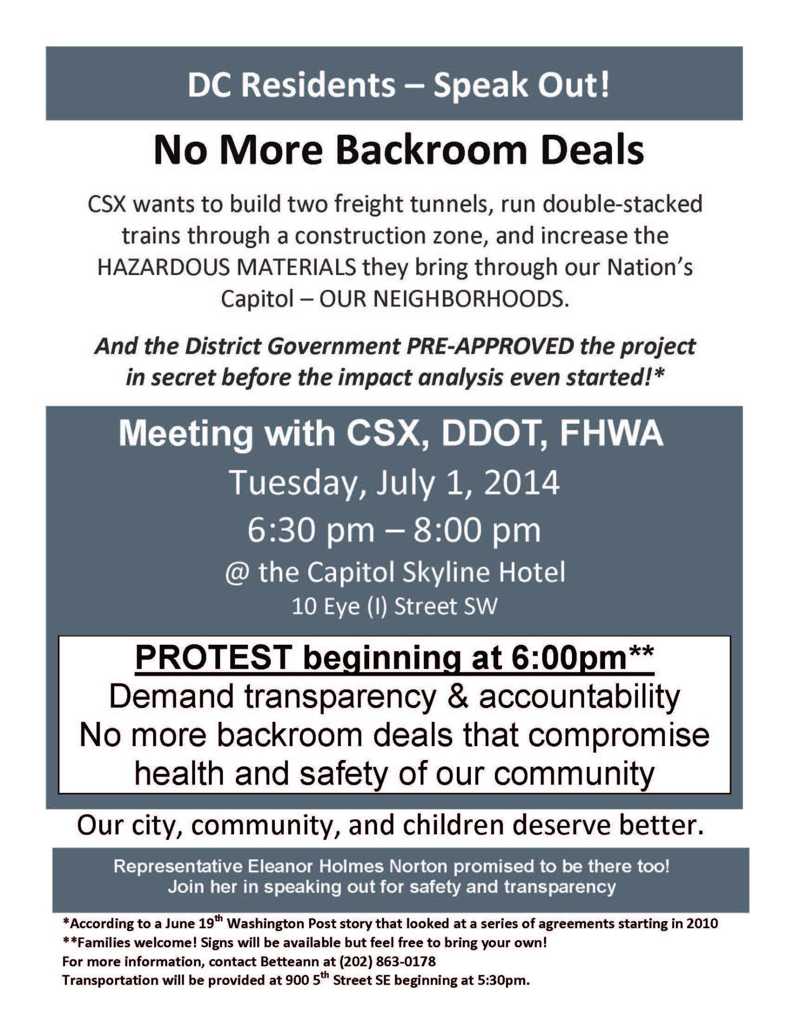
UPDATE: Before the meeting even gets off the ground, DC Del. Eleanor Holmes Norton has announced that USDOT has agreed to extend the comment period from 30 to 60 days (though she had asked for 90) and to hold a second public meeting before the end of the review period.
Comments (1)
More posts:
CSX/Virginia Ave. Tunnel, meetings
Details on Recommendations for Community Center Offerings
Jun 12, 2014 12:15 PM
 At a public meeting on Wednesday night, the team working with the DC Housing Authority unveiled what programs the consultants will be recommending be offered at the Capper community center, a list that grew out of the recent survey about residents' wishes.
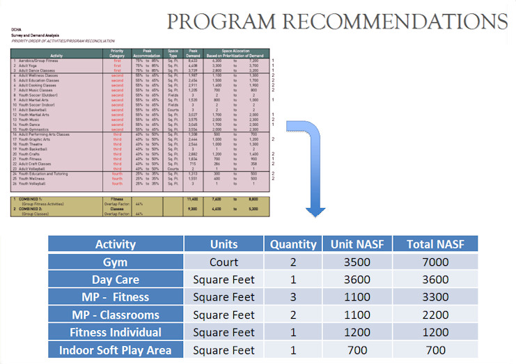
 The recommendations are:
* A 7,000-square-foot gymnasium with basketball court that can also be divided into two smaller courts when needed;
* A 3,600-square-foot day care center, which would also include a secured outdoor play area;
* Three multipurpose fitness rooms (for yoga classes or the like):
* Two multipurpose classrooms;
* One individual fitness area, which could include treadmills and weights; and
* A small "soft play area" for little kids.
The recommendations are not a written-in-stone marching order, however. Soon the Housing Authority will be putting out an RFP to find the organization that will run the community center (though apparently we're now calling it a "community building," because #branding). The operator would then have "flexibility" in what it offers, while ostensibly guided by the survey results.
There were 473 responses to the survey, and the meeting slides show both the demographic breakdown of respondents as well as the top vote-getters in both fitness and "enrichment" activities.
The slides also include conceptual drawings of how the two-story building could be laid out to handle the recommended offerings, though it was stressed that the operator will be making the final decisions on layout and whatnot. (You may remember that there was at one time a basement planned for the building, but it's now been removed from the design.)
 * FILLING WATER: After the flooding a few weeks ago took out the pumps, the Yards Park folks are now reporting that the basin is starting to be re-filled. Though it's still in a testing phase, officials are optimistic that the wait is almost over and the basin and fountains should be back in operation soon.
Attendees at the meeting did not rise up in fire-breathing opposition to the presentation, though concerns were raised about the lack of garden space, the seeming preference of fitness activities over learning/cultural/enrichment activities, and the need for space and kitchen access to accommodate private events like kids' birthday parties.
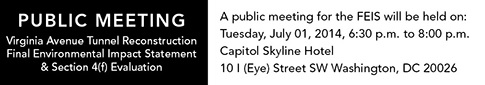 Word is hitting the streets that the public meeting for the Virginia Avenue Tunnel's Final Environmental Impact Statement is scheduled for July 1, from 6:30 pm to 8:00 pm at the Capitol Skyline Hotel. Presumably the actual document will be available before then...?
Even though the consultant's report is due to DCHA next week, the team still wants to hear comments, if you've got them.
The slides also said that the groundbreaking for the building is "about to happen," which of course translates to JDLand Speak as "Any Minute Now."
Comments (4)
More posts:
Capper, Community Center, meetings
Public Meeting for Virginia Ave. Tunnel Final EIS on July 1
Jun 10, 2014 7:12 PM
 Word is hitting the streets that the public meeting for the Virginia Avenue Tunnel's Final Environmental Impact Statement is scheduled for July 1, from 6:30 pm to 8:00 pm at the Capitol Skyline Hotel. Presumably the actual document will be available before then...?
Comments (11)
More posts:
CSX/Virginia Ave. Tunnel, meetings
Tuesday Tidbits: On the Water Front
Jun 10, 2014 11:12 AM
 * FILLING WATER: After the flooding a few weeks ago took out the pumps, the Yards Park folks are now reporting that the basin is starting to be re-filled. Though it's still in a testing phase, officials are optimistic that the wait is almost over and the basin and fountains should be back in operation soon.
* MANAGING WATER: The EPA has released the case study about Canal Park entitled Integrating Stormwater Management and Public Amenities through a Public-Private Partnership, saying that the park "exemplifies how a public-private partnership can be used to create a public amenity that enhances the community and provides environmental benefits."
* FRONTING WATER: I came *thisclose* to posting a link that just popped up in my RSS reader about how the developers of the Florida Rock site just said that they expect to begin construction on Phase I of RiverFront on the Anacostia in "mid-2014"--but then I thought to look at the date on the release, and it was May 7. So I guess could still technically be considered news, but we're now reaching "mid-2014" with no sign of movement....
* CROSSING WATER: A reminder that tonight at 6:30 is your chance to meet the four finalists in the Bridge Park design competition. The event is at 1801 Mississippi Ave., SE.
And in the No Water Connection At All Department:
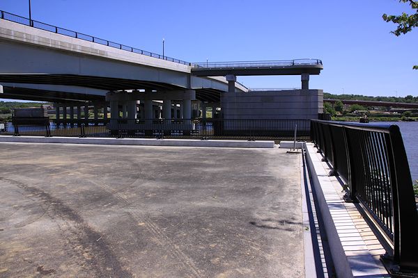 The process continues to create the 11th Street Bridge Park, with the announcement on Tuesday of the four teams picked for the final stage of the design competition.
* COMMUNITY CENTER: Tomorrow night, Wednesday, June 11, is the public meeting on the results of the Capper Community Center survey.
* VAN NESS: Greater Greater Education looks at the drive to reopen Van Ness Elementary School.
(and no, the headline isn't a typo)
Comments (2)
More posts:
bridgepark, Canal Park, Community Center, Florida Rock, meetings, Van Ness Elementary, Yards Park
Bridge Park's Final Four Design Teams Picked; Meet Them June 10
May 28, 2014 4:24 PM
 The process continues to create the 11th Street Bridge Park, with the announcement on Tuesday of the four teams picked for the final stage of the design competition.
The park, which will use the piers still standing after the demolition of the old outbound 11th Street Bridge, would create a new type of connection between the east and west sides of the Anacostia River, and is described by its supporters as "an iconic new civic space that will provide a unique venue supporting the community’s environmental, economic, cultural and physical health."
The design teams chosen are made up of landscape architects, architects, and structural engineers, and have been given $25,000 to create their submissions. The teams are:
• Balmori Associates / Cooper, Robertson & Partners / Guy Nordenson Associates
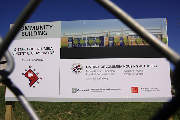 The next step in the planning for the soon-to-be-built Capper Community Center has been announced, with a public meeting scheduled for Wednesday, June 11 at 200 I St. SE at 7 pm* to discuss the results of the recent neighborhood survey on desired programs and activities at the center. The consultants hired by the Housing Authority will also present their recommendations.
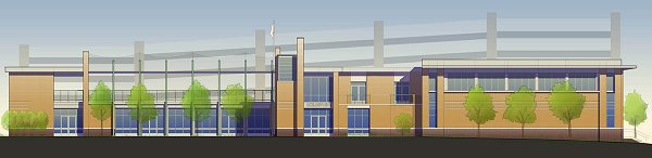
• OLIN / OMA / Arup
• Stoss Landscape Urbanism / Höweler + Yoon Architecture / Robert Silman Associates
• Wallace Roberts & Todd (WRT) / NEXT Architects / Magnusson Klemencic Associates
The park's jury expected to choose a final design this fall.
And on June 10, members of the public will be able to hear from the four teams (one of which includes OLIN, designers of Canal Park) The event runs from 6:30 to 8 pm at THEARC, 1901 Mississippi Ave., SE.
In the meantime, fundraising continues for the project, which could cost around $40 million for both construction and operations. Earlier this month council member and transportation committee chair Mary Cheh inserted into the city budget currently under deliberation $14.5 million over the next three years to partially fund the project. (This money is apparently coming from the city's decision to go with a fixed-span new Douglass Bridge rather than replacing the swing span, which is saving about $140 million.) The rest of the construction financing would be raised from private sources. In addition, about $840,000 has been raised toward the $1 million "pre-capital campaign goal."
Comments (2)
More posts:
11th Street Bridges, bridgepark, meetings
Next Capper Community Center Meeting Set for June 11
May 27, 2014 5:36 PM
 The next step in the planning for the soon-to-be-built Capper Community Center has been announced, with a public meeting scheduled for Wednesday, June 11 at 200 I St. SE at 7 pm* to discuss the results of the recent neighborhood survey on desired programs and activities at the center. The consultants hired by the Housing Authority will also present their recommendations.
Sayeth DCHA: "Over the past three weeks, almost 475 members of the Southeast neighborhood answered the 130-question surveys. Of those, more than 85 percent were from within a 10-block radius of the proposed facility. About 46 percent of those surveyed indicated they rented their home. Almost three-quarters of the surveys were completed online."
The first community meeting was held in April, and included some initial "strategic visioning," in advance of the surveys going out.
* Note the different start time from when this was initially posted.
Comments (2)
More posts:
Capper, Community Center, meetings
Presentation Slides, Responses from Community Center Meeting
Apr 22, 2014 11:47 AM
On Monday night the first public meeting was held to begin gauging neighborhood expectations and desires for the programming at the Capper Community Center, which is expected to begin construction Any Minute Now and open in late 2015. I wasn't there, but the Housing Authority was nice enough to pass along both the presentation slides that were shown by the consultants running the meeting and the entire community "engagement process." These slides also include the breakout of the responses to various questions asked during the meeting. (I'm not going to call it Visioning. I'm just not.)
 I wasn't there, but the Housing Authority was nice enough to pass along both the presentation slides that were shown by the consultants running the meeting and the entire community "engagement process." These slides also include the breakout of the responses to various questions asked during the meeting. (I'm not going to call it Visioning. I'm just not.)
 Attendees were given keypads to register their answers, and so the demographics of the 60ish folks who participated were immediately available: 62 percent of attendees were aged 60 and older, 61 percent were female, 69 percent have lived in the neighborhood for four years or more, etc. Then a series of questions about what the focus of the building's offerings should be and how the building should be operated were asked, followed by breakout small group discussions.
The next step in gathering input will be a survey that will go out in the next few weeks, which will focus on feedback about specific potential programs and activities. Another community meeting is expected in early June, with a final report issued not long afterward.
Comments (0)
More posts:
Capper, Community Center, meetings
Public Meeting on Capper Community Center Set for April 21
Apr 10, 2014 4:19 PM
The "engagement process" between DCHA (and its consultants) and interested parties about the planned Capper Community Center now has its first public meeting scheduled, for Monday, April 21, at 7 pm, at 200 I St. SE.
The announcement flyer includes an FAQ with information similar to what I wrote about not too long ago when the agency announced that it would be working with the community to determine the "inside uses" for the 30,000-square-foot building at 5th and K streets, SE, which DCHA expects to be "a support for the community building process in this new mixed-income community" as well as a "multifaceted enrichment center" and a "hub for activities and positive civic interaction."
It also explains again that DCHA will not be running and funding the center's operations--though will remain "vitally interested" --so it needs to come up with ways to create the necessary revenue to support both staff and programs.
This meeting is planned to be an information session and also hear ideas about programs for the building, then a second meeting later this spring will present preliminary programming recommendations.
Check the flyer for additional information, including the reminder that government ID is needed in order to get into 200 I St.
Both the Post and City Paper have reports on Thursday's meeting with Mayor Vince Gray where residents had the chance to air their grievances about the plans for the renovation and expansion of the Virginia Avenue Tunnel between 2nd and 12th streets, SE.
Resident groups alarmed at CSX's plans to renovate and expand the Virginia Avenue Tunnel have secured a public meeting with Mayor Vince Gray to air their concerns about the projects and its impacts, which range from the use of the tunnel for hazardous materials transport to the presence of asbestos to increased vibrations on surrounding structures to the "potential for stalled neighborhood development" and traffic congestion.
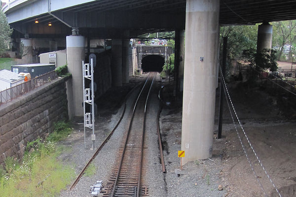 On Saturday, Nov. 23, DC delegate Eleanor Holmes Norton is having a meeting with residents to discuss the CSX/Virginia Avenue Tunnel project. It's at 2 pm at the Capper Seniors building at 900 5th St., SE.
Comments (1)
More posts:
Capper, Community Center, meetings
Residents Give Mayor a Tunnel Earful; Plus, a Dissent
Jan 20, 2014 10:07 AM
Both the Post and City Paper have reports on Thursday's meeting with Mayor Vince Gray where residents had the chance to air their grievances about the plans for the renovation and expansion of the Virginia Avenue Tunnel between 2nd and 12th streets, SE.City Paper's article opened thusly: "Navy Yard residents still unequivocally don't want the the city to give a complex Virginia Avenue Tunnel construction project the go-ahead, and last night, hundreds of neighbors came out to let Mayor Vince Gray know just how horrible they think the project is." CP wrote that Mayor Gray "facilitated the meeting and took what he referred to as 'copious notes' throughout. He didn't say much about the project itself, only promising that the city would never sign on to a project that would endanger lives: 'There's no way we would be involved in a project like that.' "
CP also has this: "Skip Elliott, vice president of public safety, health and environment at CSX, said there would be no 'unit trains' with crude oil going through the tunnel. When the meeting attendees screamed he was lying, he clarified that while there would be no unit trains—or a group of trains that typically carry a single commodity—there would be some rail cars that would carry crude."
The Post notes that "[s]ome residents say they fear the estimated three to six years of construction will lower home values and slow growth in the neighborhood." It quotes resident Natalie Skidmore: "With an open trench, we have concerns about how people are going to get around. We are going to lose parking spots, trees and access." And the article closes with a quote from James McPhillips, one of the leaders of the DCSafeRail opposition group: "We really thought the neighborhood was up and coming. It had a beautiful, inviting and diverse community[.] This project has the possibility of destroying that."
In the wake of the meeting, ANC 6D07 commissioner David Garber told his mailing list that "I believe this issue is finally on the mayor's radar -- but we need to KEEP IT THERE," suggesting that "[w]hile a hashtag won't save the world (yet) -- please consider tweeting to the mayor and including the hashtag #MayorNoBuild."However, the commissioner for another ANC single member district that will be affected by the project came out of the meeting with a different point of view, and has posted her concerns with the concerns of Virginia Avenue residents.
However, the commissioner for another ANC single member district that will be affected by the project came out of the meeting with a different point of view, and has posted her concerns with the concerns of Virginia Avenue residents. KIrsten Oldenburg, commissioner of ANC 6B04--which mainly covers Barracks Row but also includes lower 8th Street and Virginia Avenue from 7th Street to 11th Street--posted today a detailed look at the issues that the opposition groups are so vociferously arguing about, saying that "[t]his is not to say that those stridently opposed to the project don’t have a right to conduct a politicized campaign. [...] But, I don’t have to agree with the way they are using and perpetuating misinformation about what we know about the project."
OIdenburg addresses the proposed alternatives, saying that it is "Not True" that all proposed build alternatives involve running trains through open trenches, since one of the alternatives has trains running through the existing closed tunnel during construction. She notes that the draft EIS says "the maximum duration is 3.5 years for alternatives with open trench train operations and 5.5 years for the closed tunnel version," meaning that there may be a tradeoff between open-vs.-closed trench and shorter-vs.-longer duration.
She also looks at the hazardous materials and rail accidents arguments, and notes that the issue of CSX's HazMat transportation has been around since before the tunnel became a cause. After pointing out that trucks carry "unknown quantities of hazardous materials along I-695 (parallel to Virginia Avenue)," Oldenburg says that "[t]he alarms being raised on hazardous materials are diverting attention away from other more probable problems an open trench might cause."
On the issue of street closures, she looks at the disruptions as they have been outlined from the beginning of the EIS project: "But, aside from 2nd Street, all north/south crossings of Virginia Avenue will remain open during construction. Will these streets be closed occasionally and for short periods of time? Yes. Will the I-695 exit ramp at 6th Street and on ramp at 8th Street be closed for the duration? No. Will each have to be closed for a short time while decking is installed at these intersections with Virginia Avenue? Yes. Does the DEIS show special lanes to be set up to provide continuing access for residences and businesses in close proximity to the construction area? Yes."
The issue of community benefits in the wake of such a long construction project is one she feels needs more discussion, noting that 6B and others have already been advocating for green space with a pedestrian/bike patch from 3rd Street to 11th Street, along with a major redesign of Virginia Avenue Park. "But, is a linear park that will revitalize a lifeless space and serve all residents both north and south of the Freeway enough? Is it possible to equalize burdens and benefits? ... What more could/should we ask for?"
She closes with reference to the comments submitted to the DEIS, saying that the issues raised are "excellent contributions toward making the FEIS a major improvement over the DEIS," but that, "[I]n the end, the FEIS may improve our comfort level about this project but it will never satisfy everyone."
Comments (4)
More posts:
CSX/Virginia Ave. Tunnel, meetings
Meeting with Mayor on Virginia Ave. Tunnel Jan. 16
Jan 9, 2014 9:32 AM
Resident groups alarmed at CSX's plans to renovate and expand the Virginia Avenue Tunnel have secured a public meeting with Mayor Vince Gray to air their concerns about the projects and its impacts, which range from the use of the tunnel for hazardous materials transport to the presence of asbestos to increased vibrations on surrounding structures to the "potential for stalled neighborhood development" and traffic congestion.It is scheduled for Thursday, Jan. 16, at 6:30 pm at 200 I St. SE (the old Post Plant).
For more information on the meeting and on the residents' battle, see DCSafeRail.org. For more information on the tunnel project, which is currently awaiting the any-minute-now release of the Environmental Impact Statement, see my project page or CSX's official site at VirginiaAvenueTunnel.com.
Comments (1)
More posts:
CSX/Virginia Ave. Tunnel, meetings
Saturday Community Meeting on Virginia Avenue Tunnel
Nov 22, 2013 3:42 PM
On Saturday, Nov. 23, DC delegate Eleanor Holmes Norton is having a meeting with residents to discuss the CSX/Virginia Avenue Tunnel project. It's at 2 pm at the Capper Seniors building at 900 5th St., SE.With the Environmental Impact Statement for the project expected to be released before too much longer (you can see the draft EIS here), residents are seeing this as perhaps a last opportunity to voice their concerns and push back against what one resident called Norton's willingness "to simply regurgitate CSX talking points" in a recent press release.
DDOT is hosting another public meeting tonight (Thursday, Nov. 21) on its project to both turn the old sunken portion of the Southeast Freeway into "Southeast Blvd." and also to remake Barney Circle.
 I wasn't able to be at Thursday's hearing on the fate of the federally owned warehouse at Half and L Streets, but I can cobble together an update thanks to the folks who were there:
A train fire last week that began in the tunnel also has the residents who have been fighting the project intensifying their efforts to get answers they are seeking on health and safety concerns.
To that end, a new web site has also been launched, DCSafeRail.org, to lay out residents' arguments.
UPDATE, 11/26: There was a considerable kerfuffle after Saturday's meeting, at which Federal Highway Administration rep Michael Hicks said, "They're going to have to close the interstate, two exit points on the Interstate, 6th and 8th St., I believe, for the duration of the project...So that's why I'm involved." Putting aside that the only 8th Street SE exit is on the north side of the freeway and so would be nearly impossible to be impacted by the tunnel construction, this statement went against the Draft Environmental Impact Statement as well as many comments by CSX and DDOT during the process that the 6th Street exit ramp would not be closed.
As I expected, there is now a statement that's been sent out by CSX, from Hicks:
"My apologies to the community, turns out I made a misstatement regarding the duration of closures of the 6th St exit and 8th Street on ramp to I-695 and I understand that statement, unfortunately, has gotten widespread exposure. Hopefully the clarification to follow is equally widespread; no highway ramps would be closed for the duration of construction. As outlined in the DEIS, erecting the temporary decks at 5th/6th and 8th Streets SE may require the short term closure (approximately a week or less) of I-695 ramps at these locations. CSX would work with DDOT, community leaders and local first responders to ensure access for community members in the event of emergencies!
"During the very preliminary stages of project development it was thought the ramps might possibly have to be closed; however, alternatives were developed that no longer required extended closures of those ramps. Again, I apologize for any concern or alarm my misstatement may have caused. Thank you."
Comments (8)
More posts:
CSX/Virginia Ave. Tunnel, meetings
Southeast Blvd. and Barney Circle Public Meeting Nov. 21
Nov 21, 2013 1:28 AM
DDOT is hosting another public meeting tonight (Thursday, Nov. 21) on its project to both turn the old sunken portion of the Southeast Freeway into "Southeast Blvd." and also to remake Barney Circle. This meeting will "seek community feedback on updated design concepts" that "illustrate ways to transform the Southeast Freeway between 11th Street SE and Barney Circle into a boulevard that integrates with adjacent neighborhoods and provides new connections to the Anacostia River."
The meeting is from 6:30 to 8:30 pm at Payne Elementary School, 1445 C St., SE.
This is a study that I'm actually pretty interested in, but I missed the previous meeting and ensuing discussions owing to my Annus Horribilis, so I can't give you a whole lot of details on how it has all gone up to now. The project web site has the basics, including the presentation slides from the first meeting, and ANC commissioner Kirsten Oldenburg posted 6B's first comments on the concepts back in April.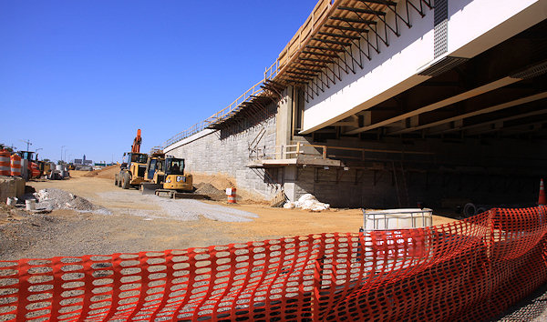 Some of the work on Southeast Blvd. has of course already begun, with tons and tons of dirt already having filled in the former underpass beneath 11th Street, so that traffic coming from the freeway will be able to exit to a signalized intersection at 11th. But little work has been done east of 11th, which is good since it's this study that is to determine exactly what that work should be.
 Some of the work on Southeast Blvd. has of course already begun, with tons and tons of dirt already having filled in the former underpass beneath 11th Street, so that traffic coming from the freeway will be able to exit to a signalized intersection at 11th. But little work has been done east of 11th, which is good since it's this study that is to determine exactly what that work should be.
Also, if you can't get enough of public meetings on transportation issues, you can also mark your calendar for an upcoming DDOT meeting regarding updates to the Anacostia Waterfront Initiative Transportation Master Plan. It's on Dec. 12 from 6:30 to 8:30 pm at the Capitol Skyline Hotel at South Capitol and I streets, SW.
Comments (4)
More posts:
meetings, Southeast Blvd., Traffic Issues
Cobbled-Together Coverage of Half Street Market Hearing
Apr 26, 2013 9:39 AM
I wasn't able to be at Thursday's hearing on the fate of the federally owned warehouse at Half and L Streets, but I can cobble together an update thanks to the folks who were there:City Paper: "A group of Capitol Riverfront residents has been pushing to turn a vacant warehouse at 49 L Street SE into a community amenity called the Half Street Market. But if a congressional hearing there this morning was any indication, they may be facing an uphill battle."
WashPost: "An official for the General Services Administration, which manges federal real estate, told the representatives that the 32,013-square-foot brick building was no longer needed by the government and that the agency was in the process of preparing it to be sold or traded for construction services on other projects, for which the GSA is in need of funding.
"'Given the high real estate value and rate of growth in the surrounding Capitol Riverfront neighborhood, the 49 L Street property presents us with many potential opportunities to find a better use for or to dispose of a vacant property from the federal real estate inventory and provide considerable savings to taxpayers,' said Michael Gelber, acting deputy commissioner of the GSA’s Public Buildings Service."
WBJ: "D.C. Councilman Tommy Wells, D-Ward 6, testified, saying that the District could be willing to put up the $19 million price tag for the property. U.S. Del. Eleanor Holmes Norton, D-D.C., spoke passionately in support of the project.
"The will is certainly there. But what of the way?
WashPost: "The GSA, however, is not in the business of giving away property at a discount even if its acting administrator, Dan Tangherlini, is a former D.C. city administrator and transportation official. Gelber reiterated in an interview that the agency’s preference was to trade the building for construction services, similar to the way the GSA is trying to use the J. Edgar Hoover Building as a trading chip for a new FBI headquarters elsewhere in the region.
"GSA has not disclosed how much it believes the L Street warehouse is worth but Gelber said putting it up for auction, as the agency did with the West Heating Plant, would likely fetch the highest price. Adding a requirement that a market be part of the redevelopment wasn't likely to help the sales price — quite the opposite. 'The more conditions you put on a sale the more that you affect valuation,' he said.
City Paper: "So it appears likely that the feds will be selling the property to the highest bidder—and with Union Market and Eastern Market both within a few miles of the site, the highest bidder probably won't want another market there."
News came via Twitter on Thursday that the House Committee on Oversight and Government Reform's Government Operations subcommittee will be holding a hearing on the future use of the empty warehouse owned by the Feds at Half and L SE, the building being eyed by neighbors as the potential Half Street Market.
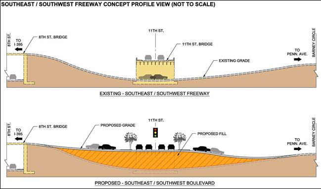 With the reconstruction of the old Southeast Freeway east of 8th Street into the new Southeast Blvd., DDOT is running a transportation planning study that is looking how best to integrate this rebuilt stretch of road with the adjacent neighborhoods between 11th Street and Barney Circle. To that end, there is a public meeting about this "opportunity for adaptive reuse" being held this Thursday, Feb. 21, at 6:30 pm at Payne Elementary School at 1445 C St., SE. Representatives of DDOT and the technical team working on Southeast Blvd. will be there to provide details about the study and future plans for the area, as well as to answer questions.
 The resident organizers of a drive to transform the warehouse at Half and L Streets SE into a "Half Street Market" are holding a public meeting on Tuesday, Feb. 19 at 7 pm at 200 I Street (aka the Post Plant, aka 225 Virginia Avenue).
 For those in the neighborhood who have some concerns about the lovely Capitol Power Plant, which sits just north of the Southeast Freeway but which reaches down to I Street SE just west of 70/100 I, there is a public meeting Thursday, Jan. 24, hosted by Tommy Wells.
The August edition of the Virginia Avenue Tunnel newsletter is out, with the news that another public meeting on the project is scheduled for Sept. 27, from 6 pm to 8 pm at the Capitol Skyline Hotel. The meeting is described as providing an update on the project and to "share information about the alternatives being evaluated in the Draft Environmental Impact Statement (EIS)." In other words, this isn't the meeting to unveil the draft EIS, which is expected to come this fall.
 The Office of Planning isn't exactly lighting up the Intertubes promoting this, but apparently there's another "informational meeting" on the notion of turning the old outbound 11th Street Bridge into a "recreational bridge" tonight at 6:30 pm at the Lumber Shed in the Yards Park.
JDLand: It's also worth noting that 50 M Street, the empty lot on the south end of the warehouse's block, fronting M Street directly across from the Navy Yard Metro station entrance, is now on the market, making it possible for a developer to have the entire block if it were to gain control of the warehouse and buy the 50 M site.
UPDATE: Here's Urban Turf's take on the hearing, which includes this:
"A sizable contingent (for a Thursday morning) came out to the meeting in support of the Half Street concept, and Councilmember Tommy Wells and ANC 6D Commissioner Ed Kaminski testified in support of the project. Kaminski brought up a potential revenue stream that could help fund the market and culinary incubators on the ground floor: a boutique hotel on the upper floors could send a stream of cash to the GSA. Generally, Kaminski felt that the air rights over the warehouse could be utilized in a profitable manner.
The representatives seemed supportive of the local officials, and were open to the prospect of putting in motion a process that would lead to selling the building to the city. However, the question remains: can DC afford it?"
Comments (23)
More posts:
49l, halfstmarket, meetings
Congressional Hearing April 25 on Empty L Street Warehouse
Apr 18, 2013 9:23 PM
News came via Twitter on Thursday that the House Committee on Oversight and Government Reform's Government Operations subcommittee will be holding a hearing on the future use of the empty warehouse owned by the Feds at Half and L SE, the building being eyed by neighbors as the potential Half Street Market. Tommy Wells and ANC 6D02 commissioner Ed Kaminski will be testifying in support of returning the building back to DC's control, and to make it all even more festive, the hearing is going to be held in the warehouse itself, at 9:30 am on Thursday, April 25.
Rep. John Mica (R-Fla.), who is the chair of the committee, has been making his displeasure known about the (lack of) speed with which GSA has been disposing of excess property. And, as Housing Complex puts it today, "At the time, Rep. Jeff Denham (R-Calif.) said the subcommittee would consider holding hearings at vacant federal properties around the country if GSA didn't start moving on them more quickly. Now, the congressmen appear to be making good on their pledge."
Comments (12)
More posts:
49l, halfstmarket, meetings
Public Meeting Feb. 21 on Southeast Blvd., Barney Circle Planning
Feb 18, 2013 11:26 AM
With the reconstruction of the old Southeast Freeway east of 8th Street into the new Southeast Blvd., DDOT is running a transportation planning study that is looking how best to integrate this rebuilt stretch of road with the adjacent neighborhoods between 11th Street and Barney Circle. To that end, there is a public meeting about this "opportunity for adaptive reuse" being held this Thursday, Feb. 21, at 6:30 pm at Payne Elementary School at 1445 C St., SE. Representatives of DDOT and the technical team working on Southeast Blvd. will be there to provide details about the study and future plans for the area, as well as to answer questions. This would probably be the perfect forum to ask some of the questions that have been posted in the comments here, such as whether the new boulevard will have an intersection with 13th Street, and how the pedestrian/cycling trail planned to be built alongside the boulevard will be handled.
Comments (2)
More posts:
meetings, Southeast Blvd., Traffic Issues
Half Street Market Public Meeting on Tuesday, Feb. 19
Feb 18, 2013 10:51 AM
The resident organizers of a drive to transform the warehouse at Half and L Streets SE into a "Half Street Market" are holding a public meeting on Tuesday, Feb. 19 at 7 pm at 200 I Street (aka the Post Plant, aka 225 Virginia Avenue). The "idea and design team" -- now with neighboring ANC 6D07 commissioner David Garber taking on a larger role and 6D02 commissioner Ed Kaminski having "stepped away," according to Garber -- are wanting to have the building become a "public market, restaurant(s), and culinary incubator/training center."
There's no indication from GSA that the building's move to the surplus list is imminent, and there's also questions on how exactly the building (on such valuable land, just north of the Navy Yard Metro station's Half Street entrance) would escape being auctioned to net the feds millions of dollars and instead be transferred to the city and/or some as-yet-uncreated nonprofit group. This would have to happen under the federal guidelines for acquiring federal real property for educational purposes, which includes applying to the Department of Education to sponsor the transfer and which would seem to require that the incubator/training center be the centerpiece of the building's new mission. On the other hand, Garber recently described the project in an e-mail to his neighborhood mailing list as "still in its infancy and constantly evolving," so no doubt the organizers of the drive to acquire the building have a plan they feel will meet the feds' requirements.
I probably won't be at the meeting, so if you're interested in the project, best get thee to 200 I on Tuesday rather than looking for a summary here.
Comments (0)
More posts:
49l, halfstmarket, meetings
Public Meeting Thursday to Discuss Capitol Power Plant
Jan 23, 2013 7:00 PM
 For those in the neighborhood who have some concerns about the lovely Capitol Power Plant, which sits just north of the Southeast Freeway but which reaches down to I Street SE just west of 70/100 I, there is a public meeting Thursday, Jan. 24, hosted by Tommy Wells.
 Withthe recent application by the Architect of the Capitol for changes to the plant's permits bringing renewed push-back from the community about the plant's continuing burning of coal, Wells has organized the meeting to "hear your concerns and discuss next steps." The District Department of the Environment will be there to present background information about the plant, and Wells is also intending to include a discussion of "strategies for addressing broader concerns about the power plant, particularly the ongoing use of coal as a fuel source."
The Architect of the Capitol has posted these responses to the questions raised about the permits. (Unfortunately, I can't suppress a snicker at the photo used to show the plant, taken on tulip-filled spring day from one of the parks along D Street SE, showing the plant in a fabulously bucolic setting. My photo might be a bit more realistic.)
The meeting is at 6:30 pm at United Methodist Church, 421 Seward Square SE (just south of Pennsylvania Avenue between 4th and 5th streets).
Comments (4)
More posts:
meetings, powerplant
Another Virginia Avenue Tunnel Meeting Scheduled for Sept. 27
Aug 20, 2012 11:24 AM
The August edition of the Virginia Avenue Tunnel newsletter is out, with the news that another public meeting on the project is scheduled for Sept. 27, from 6 pm to 8 pm at the Capitol Skyline Hotel. The meeting is described as providing an update on the project and to "share information about the alternatives being evaluated in the Draft Environmental Impact Statement (EIS)." In other words, this isn't the meeting to unveil the draft EIS, which is expected to come this fall.There isn't much else of note in the newsletter (noise studies ongoing, Section 106 historic preservation review ongoing, how to comment, etc.), so I'll admit this post is mainly a sneaky way to once again point out my new Virginia Avenue Tunnel page, where you can get an overview of this project and see the concepts currently being evaluated, along with plenty of photos from along the tunnel's path.
Comments (0)
More posts:
CSX/Virginia Ave. Tunnel, meetings
11th Street Recreation Bridges Meeting Tonight
Jun 19, 2012 10:13 AM
 The Office of Planning isn't exactly lighting up the Intertubes promoting this, but apparently there's another "informational meeting" on the notion of turning the old outbound 11th Street Bridge into a "recreational bridge" tonight at 6:30 pm at the Lumber Shed in the Yards Park.
According to an e-mail forwarded around by ANC commissioner David Garber (I haven't seen mention of the event anywhere else), the meeting's primary purpose is to get ideas about the kinds of attractions and features that OP would then want to put into the design competition they plan to hold for the bridge. There's no funding for any actual construction at this point, and a private partner would probably have to be found to foot the not-miniscule tab to build a new decking across the river on the footings that will remain now that the current deck is being demolished.
Comments (0)
More posts:
11th Street Bridges, meetings
ANC 6D Agenda: Parking Update, Capper PUD (and the Wharf)
Jun 8, 2012 10:10 AM
The agenda for the June 11 ANC 6D meeting has been sent out (and hopefully posted soon). The big-ticket item is a vote on the Stage 2 PUD for the Southwest Waterfront plans, which I doubt will be a lightning-quick discussion--when the agenda has it budgeted for 90 minutes, you know it's gonna be long.
But there are also two Near Southeast items of interest listed: an update on baseball game-day parking from DDOT (first discussed at the May meeting) and the Capper Community Center PUD extension request (also discussed in May).
I'm not yet up to sitting through a meeting of that length (though I'm coming along), so if these items are of interest, get thee to 1100 4th St. SW at 7 pm on Monday.
Virginia Avenue Tunnel Meeting Presentation Slides, Boards
May 29, 2012 11:51 AM
I wasn't able to attend last week's public meeting on the Virginia Avenue Tunnel, but the presentation slides and display boards are posted on the project's web site.
This is the stage of the Environmental Impact study where the initial lineup of possible concepts have been winnowed down to the four that will be evaluated for the final EIS:
* Concept 1 - "No Build" (i.e., leave as is);
* Concept 2 - Rebuild tunnel with a temporary track running in an open trench to the south of the existing tunnel;
* Concept 5 - "Permanent Twin Tunnels," with a new tunnel built via open trench to the south of the existing tunnel, which would be rebuilt as well;
* Concept 6 - "Rebuild Online," where the current tunnel would be rebuilt via open trench along the existing alignment, and trains would run in that same trench during construction.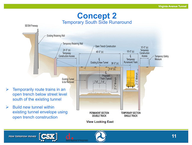
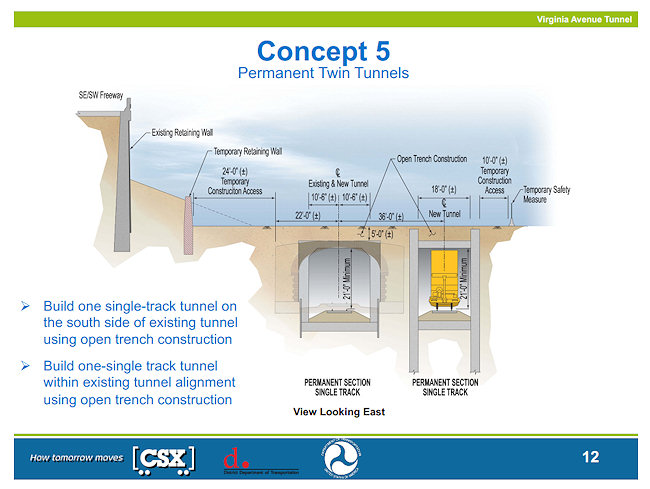
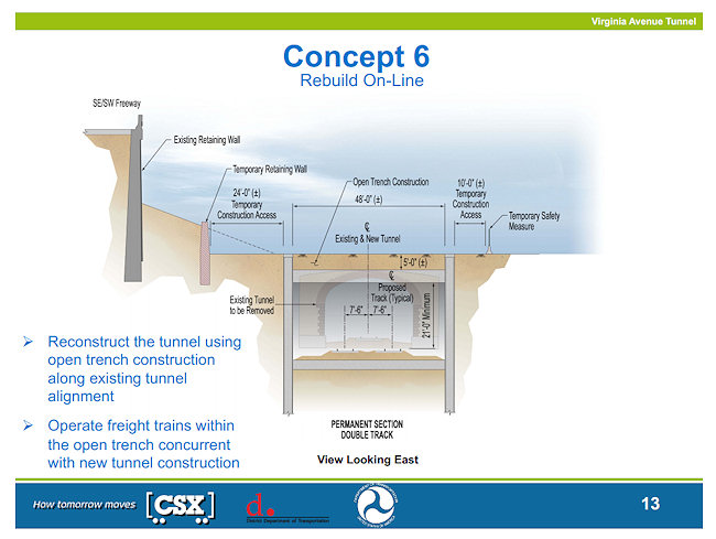


Also contained in the slides is information about how traffic would be routed with the closure of Virginia Avenue on the south side of the freeway between 2nd and 11th. As has always been stated, north/south traffic on the numbered streets would be maintained across Virginia, and temporary driveways/access are shown on 3rd and 4th Street for Capitol Quarter and the 200 I/225 Virginia loading dock. It's also shown that Virginia Avenue north of the freeway would become two-way between 6th and 8th streets, so that traffic exiting the Southeast Freeway at 6th would all be directed left under the freeway and then would be able to continue to 8th Street on Virginia.
There's also some slides on the vibration and noise analyses being done, and how Virginia Avenue might be improved after construction is completed (with bike lanes being a possibility, which immediately warmed David Garber's heart).
The draft Environmental Impact Statement is expected to be released this fall, in which the design for construction will be identified; the entire process would be completed in spring, 2013. Comments can be submitted to contact@virginiaavenuetunnel.com or via the web site.
Comments (0)
More posts:
CSX/Virginia Ave. Tunnel, meetings, Traffic Issues
This Week: Virginia Ave. Tunnel, M St. Meetings, First Front Flick
May 20, 2012 11:30 AM
To allow you to properly plan your calendar for the week, I'm posting this nice and early:
* Virginia Avenue Tunnel: Monday night is another public meeting on the planned Virginia Avenue Tunnel reconstruction, at which it's expected that DDOT, FHWA, and CSX will be presenting the concepts that have been chosen from the original batch to study in detail as part of the project's EIS. The meeting is at Nationals Park at 6 pm.
And, speaking of the tunnel, the noise and vibration field studies required as part of the EIS will be happening this week. (But no fair stomping on the ground and gunning your car's engines for hours at a time.)
* M Street SE/SW Transportation Study: The meeting to update the public on the progress of the M Street SE/SW Transportation Study is on Thursday, May 24, from 6:30 pm to 8 pm at the Capitol Skyline Hotel, 10 I St. SW. The study area covers the stretch of M from 12th Street, SE to 14th Street, SW, along with the adjacent areas from the Southeast/Southwest Freeway south to the Anacostia River/Washington Channel. DDOT is looking at "how to integrate transit, bicycling and walking with motor vehicle traffic," while also trying to figure out how to balance residents' preferences for how M Street should be configured versus how visitors, workers, and commuters expect it to flow. The first meeting was in January, and the final report is expected in the fall.
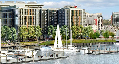 At Monday's ANC 6D meeting, representatives of MRP Realty made a presentation showing the updates to the RiverFront on the Anacostia project (aka Florida Rock) that they will be taking to the Zoning Commission later this year.
* Front Flicks: If you are looking for something slightly more entertaining than either of the week's meetings, don't forget that the Capitol Riverfront BID's free Front Flicks Summer Outdoor Movie Series begins this week on Thursday, with "Lara Croft: Tomb Raider" leading off the lineup of treasure hunt-themed offerings. Movies start either at 8:45 pm/sundown at Tingey Plaza, just behind USDOT at New Jersey and Tingey.
Alas, I won't be at any of these events, because first thing Tuesday I'm headed to the disabled list, to get some health issues dealt with that have been dragging me down for awhile now. There will be a few weeks of recovery time, so I ask all parties to please refrain from making any news before, say, mid-June, or at least make it something simple and/or something that won't require my attendance. (DDOT is already On Notice if they do indeed partially open the 11th Street Local bridge when I can't document it.)
I imagine I'll reappear on Twitter fairly quickly, since I know better than to think I can stay off the Internet while I'm doing little but laying around. But most likely the bulk of my narcotics-tinged/boredom-induced missives will be via my non-official @jacdupree account, if you want the entertainment.
In the meantime, feel free to use this post's comments to discuss this week's meetings and as a general open thread, but I will be watching and popping in, so don't you kids think you can throw a wild party while Mom's not looking! And hopefully I'll be back to photo taking and other obsessive-compulsive pursuits before too long.
Comments (3)
More posts:
Pedestrian/Cycling Issues, CSX/Virginia Ave. Tunnel, Events, meetings, M Street, JDLand stuff, Traffic Issues
Florida Rock Update at ANC 6D: Tweaked Designs, More Retail
May 16, 2012 7:56 AM
At Monday's ANC 6D meeting, representatives of MRP Realty made a presentation showing the updates to the RiverFront on the Anacostia project (aka Florida Rock) that they will be taking to the Zoning Commission later this year. These designs are part of the quest to make changes to the original design approved by the commission in 2008, chief of which is to switch the first phase of the 1.1-million-square-foot mixed-use project from an office building to a 300ish-unit apartment building at 1st Street and Potomac Avenue, along with a series of other changes that I've written about previously. (Dear heavens, don't make me write it all again.)
Here are the slides that were presented by the developers, which should be of interest even without the accompanying narration. The renderings are much more detailed and "showier" than those given to the Zoning Commission back in February, which was part of what the developers were tasked with providing in their next go-round with the ZC.
Most obviously, the developers appear to have gotten the "more retail!" message that had been delivered pretty clearly at the last two zoning commission sessions on the new design, with 18,650 square feet of retail now covering most of the first floor of the Phase I residential building, bumped up from 12,520 sf in the previous version (some of which the developers had been wanting to mark off for "temporary resident uses" until the market for retail in the area could be proven). The entire site is now designed to have 48,360 sf of retail, but this is still down from the 64,200 sf that was in the plans approved by the Zoning Commission back in 2008. (This increase in retail also means that the "four red doors" facing Potomac Avenue that sent zoning commissioner Michael Turnbull through the roof back in February are now gone.) 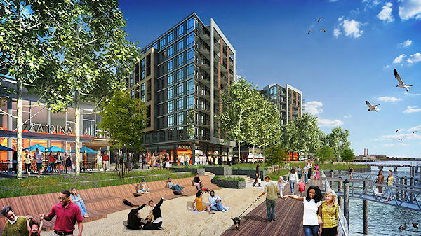 There was also much time spent on the designs for the public spaces that span the 5.5-acre site. With large lawns, wetlands-type areas that would actually be bio-filtration mechanisms, quieter tree-covered spaces, and a marina that could potentially have 40-50 slips, the additions could be seen as echoing the Yards Park a couple blocks to the east.. But there are also some "beach" areas where sand would be placed, and a large sculpture could be included in the "Riverfront Plaza" at the foot of 1st Street. The esplanade is still a major part of the design, but there is no longer a separate bike path--pedestrians and cyclists would share the boardwalk as it runs through the entire site, from South Capitol Street to Diamond Teague Park. And there may even be locations where some of the concrete blocks from the old concrete plant site would be incorporated into the public spaces.
 There was also much time spent on the designs for the public spaces that span the 5.5-acre site. With large lawns, wetlands-type areas that would actually be bio-filtration mechanisms, quieter tree-covered spaces, and a marina that could potentially have 40-50 slips, the additions could be seen as echoing the Yards Park a couple blocks to the east.. But there are also some "beach" areas where sand would be placed, and a large sculpture could be included in the "Riverfront Plaza" at the foot of 1st Street. The esplanade is still a major part of the design, but there is no longer a separate bike path--pedestrians and cyclists would share the boardwalk as it runs through the entire site, from South Capitol Street to Diamond Teague Park. And there may even be locations where some of the concrete blocks from the old concrete plant site would be incorporated into the public spaces.
I could write more about the specifics, but since the project will be back in front of ANC 6D looking for a resolution of support in July, and then at the Zoning Commission on Sept. 20, I'd prefer to save some words for the presentations to come.
I've added some of the renderings from this presentation to my Florida Rock project page. And, when looking at all of this, remember that the western two buildings (phases 3 and 4, an office building and a hotel), are not be able to be built until the new South Capitol Street/Douglass Bridge is built a bit to the south of the current bridge, which now runs directly through the Florida Rock footprint. And there's as yet no timeline for that new bridge.
Comments (3)
ANC 6D Recap 2: Canal Park, Community Center, CSX Letter
May 15, 2012 1:35 PM
Moving from the "P" portion of Monday's ANC 6D meeting (pylons and parking) to the "C"s: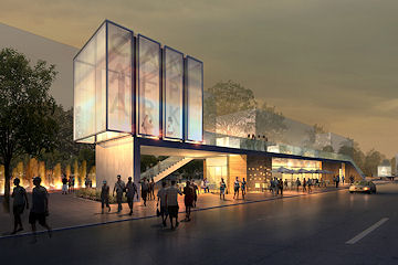 * Canal Park: Chris Vanarsdale of the Canal Park Development Association gave an update on construction, the bottom line of which has not changed from what's been mentioned the past few months, that because of unexpected issues, the park's opening has been delayed until November. Unmapped utilities that required a redesign of the stormwater management system have been a big stumbling block, but Vanarsdale also mentioned the soil-related difficulties when building on the site of an old canal. Construction is now 60 percent complete, and the work on the pavilion is almost done. Here are the presentation slides, and you can also check out the official web site for more details (along with my project page). Oh, and they're thinking about offering Zamboni driving lessons!
* Canal Park: Chris Vanarsdale of the Canal Park Development Association gave an update on construction, the bottom line of which has not changed from what's been mentioned the past few months, that because of unexpected issues, the park's opening has been delayed until November. Unmapped utilities that required a redesign of the stormwater management system have been a big stumbling block, but Vanarsdale also mentioned the soil-related difficulties when building on the site of an old canal. Construction is now 60 percent complete, and the work on the pavilion is almost done. Here are the presentation slides, and you can also check out the official web site for more details (along with my project page). Oh, and they're thinking about offering Zamboni driving lessons!* Community Center: The DC Housing Authority has filed a request with the Zoning Commission for an extension for construction of the planned Capper Community Center, which already received one extension back in 2010 that 6D supported. DCHA has apparently requested that the Zoning Commission act within 30 days on the request, news of which the ANC received on Monday. So the commissioners voted unanimously to send a letter urging postponement of the zoning case so that the ANC can address the request and form a response with a vote at next month's meeting. Commissioners Litsky and McBee also both commented that the project shouldn't be getting another extension.
UPDATE: Here is the letter sent on behalf of DCHA to the Zoning Commission asking for the extension: it would be for two years, requiring building permits by July 1, 2014 and construction underway by July 1, 2015.
* CSX/Virginia Avenue Tunnel: The commissioners voted 6-0-1 to send this letter to the appropriate parties laying out the ANC's opinion on the plans to reconfigure the Virginia Avenue Tunnel. After listing the various ways that the proposed construction "would put people, homes, businesses, and fragile historic resources at risk," the letter states: "[W]e strongly believe that the best options for our community are for CSX to either leave the Virginia Avenue Tunnel in its current state (Concept 1) -- with the suggestion that if this option were chosen that the tunnel would be fully maintained for the safety of both the trains below and the communities above, or to reroute additional train traffic outside the District of Columbia [...] instead of in an expanded Virginia Avenue Tunnel." But, if the construction does occur, "it is absolutely imperative that the health and safety of our many residents, the economic and physical well-being of our businesses, parks, religious institutions, homes, and historic buildings, and the north-south access for all existing modes of transportation be preserved and enhanced." A number of Capitol Quarter residents in attendance also spoke in support of the ANC's support. The next public meeting on the plans for the tunnel will be May 21 at 6:30 pm at Nats Park.
One more recap post to go, probably tomorrow.
Comments (6)
ANC 6D Recap 1: Water Pylons, and Parking
May 15, 2012 9:49 AM
It was a busy ANC 6D meeting on Monday night for Near Southeast-related issues, so I'm going to put it all in a series of posts: * New Jersey Avenue Underpass Art: The Capitol Riverfront BID gave an update on the "Water Pylons" art installation, which is now moving forward after being "dormant" for about a year. This is the project partially funded by a grant from the DC Commission on Arts and Humanities that will paint and light the pylons holding up the Southeast Freeway in a "modern representation of water that announces New Jersey Avenue, SE as a gateway to the Capitol Riverfront community." The reflective blue paint should go up in July, followed by light fixtures in August, and the installation should be dedicated in September, which will be right around the time that DCCAH moves into its new nearby digs at 225 Virginia/200 I. Passers-by may note that new fences and LED overhead lighting have already been installed along New Jersey as part of the transformation of the underpass. The BID's presentation to the ANC, with more information about the project, is here.
 * New Jersey Avenue Underpass Art: The Capitol Riverfront BID gave an update on the "Water Pylons" art installation, which is now moving forward after being "dormant" for about a year. This is the project partially funded by a grant from the DC Commission on Arts and Humanities that will paint and light the pylons holding up the Southeast Freeway in a "modern representation of water that announces New Jersey Avenue, SE as a gateway to the Capitol Riverfront community." The reflective blue paint should go up in July, followed by light fixtures in August, and the installation should be dedicated in September, which will be right around the time that DCCAH moves into its new nearby digs at 225 Virginia/200 I. Passers-by may note that new fences and LED overhead lighting have already been installed along New Jersey as part of the transformation of the underpass. The BID's presentation to the ANC, with more information about the project, is here.
* Parking Parking Parking: There was a discussion about issues with game-day parking in the neighborhood, specifically the prohibition of parking along K and L streets, as well as other restrictions that have made residents unhappy. Damon Harvey of DDOT says that the agency is "reassessing" the current configuration, to figure out how to provide better access to residents while not allowing stadium-goers to then hog all the parking. He expects that changes will be announced in a month or so that will allow for "greater residential protection during games." One other non-game day change for residents has already gone into effect: meters are now turned off at 6:30 pm (but still 10 pm on game days).
However, those who came to the meeting hoping to hear about changes in the Residential Parking Permit system that would allow residents in the high-rise buildings west of Canal Park to park on the street throughout Ward 6 were disappointed, as DDOT continues to hold that large residential buildings in mixed-use neighborhoods will not qualify for RPP. (Harvey used the Ellington on U Street as a specific example of this being the case elsewhere in the city, but there are more buildings in this situation than just that one and the Near Southeast ones.)
Also, in somewhat related news the ANC unanimously passed a resolution protesting the plan in the mayor's new budget to redirect most performance parking proceeds to other areas, such as Metro, rather than their being used as originally intended, to fund non-automotive transportation improvements in the neighborhood.
Comments (11)
ANC 6D Monthly Meeting Comes to Near Southeast May 14 (Updated)
May 14, 2012 11:14 AM
For its May 14 business meeting, ANC 6D is venturing east of South Capitol Street, holding the session at the Courtyard by Marriott at 140 L St., SE, starting at 7 pm. The full agenda isn't posted yet, but a flyer sent around by chair Andy Litsky includes the following items: ANC 6D CSX Virginia Avenue Tunnel letter, Update on Canal Park Construction, Discussion of Game Day Parking Issues, and New Jersey Avenue Public Art Piers (which I assume is the "Water Pylons" project that the BID received a grant for a while back).
UPDATE: I bumped this to the top of the page as a reminder, since the meeting is tonight. The agenda has been posted, and now includes an update on the Florida Rock/RiverFront plans, in addition to the items mentioned above along with some issues of importance in Southwest and various races and events that want approval to come through the neighborhood(s).
Judging from a new case filed with the Office of Zoning, it looks like the Florida Rock folks are asking for a one-year time extension on their previously approved PUD, but I imagine that will all be discussed this evening.
UPDATE II: Should clarify that the original PUD extension was through June 27, 2012, which was going to be pretty hard to meet with their filings from earlier this year to change the first phase from office to residential still working through the process. This new request would give them until June of 2013 to either get their requested modifications approved, or revert back to the original approved plans.
M Street SE/SW Transportation Study Public Meeting May 24
May 8, 2012 9:08 AM
DDOT has announced that a meeting to update the public on the progress of the M Street SE/SW Transportation Study has been scheduled for May 24, from 6:30 pm to 8 pm at the Capitol Skyline Hotel, 10 I St. SW.
The study area covers the stretch of M from 12th Street, SE to 14th Street, SW, along with the adjacent areas from the Southeast/Southwest Freeway south to the Anacostia River/Washington Channel. DDOT is looking at "how to integrate transit, bicycling and walking with motor vehicle traffic," while also trying to figure out how to balance residents' preferences for how M Street should be configured versus how visitors, workers, and commuters expect it to flow.
The first meeting, back in January, included an introduction to the study before attendees broke up into small groups to give feedback about the issues they feel need addressing.
According to the web site, a draft study report is expected this summer, with the final report and a final public meeting coming in the fall.
Comments (1)
Next Virginia Avenue Tunnel Public Meeting May 21
May 4, 2012 9:06 AM
This flyer, just posted on the Virginia Avenue Tunnel Project web site, announces that the next public meeting about the project will be on May 21 from 6 to 8 pm at Nationals Park. "During this public meeting, the concepts to move forward in the EIS will be announced." Read my post from Wednesday for more information on the whole EIS thing, and this one from the last meeting to find out more about the initial concepts that were looked at, and that will form the basis for the ones chosen to be studied further.
Comments (0)
More posts:
CSX/Virginia Ave. Tunnel, meetings
Monday Tidbits: Justin's Block Party and Farther-Off Events
Mar 26, 2012 10:05 AM
I'm going to be a bit scarce this week, so here's few events-related tidbits to keep the home page from having the equivalent of electronic tumbleweeds blowing across it:
* Don't forget that the public meeting about the possible recreational re-use of the old outbound 11th Street Bridge span is on Wednesday, March 28, at 6:30 pm.
* Justin's Cafe has now posted the information on its April 14 block party, both on Facebook and its new JustinsCafeEvents.com web site. It will run from 11 am to 9 pm, offering a line-up of local craft brews (including "beer trucks" from Port City Brewery and DC Brau), and 106.7 The Fan FM will be broadcasting from there. "All ages welcomed, 21 and over to drink." Money is also being raised for free youth baseball and softball programs through the DC Grays and S.M.A.R.T. Camps and Clinics. (The Nats play the Reds at 4:05 pm that day.)
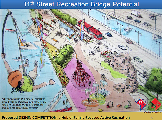 This was mentioned last week when the news first came out, but now there's confirmation via a flyer from the Office of Planning that an "informational meeting" will be held on March 28 at 6:30 pm about the "Potential Recreation Reuse of 11th Street Bridge, SE."
Via TheWashCycle, the city is apparently looking at the concept of transforming the downstream, soon-to-be-abandoned outbound 11th Street Bridge into an "11th Street Recreation Bridge," calling it an "opportunity for a destination linking river trails and recreation amenities."
This PDF from the Office of Planning (interestingly, it has the file name "Constituent Request.pdf") has a couple of concept drawings, some graphs about development in the surrounding areas, and keeps mentioning a "proposed design competition" to generate ideas for how the span could be used after the new 11th Street Local Bridge opens this summer.
There's been back-room chatter for a while that Office of Planning director Harriet Tregoning has been interested in preserving one of the existing bridge spans as a potential "High Line" for Washington, DC, and there have also been calls from various residents (including Near Southeast's own Man About Town David Garber) to build some sort of pedestrian bridge linking the two shores of the Anacostia River.
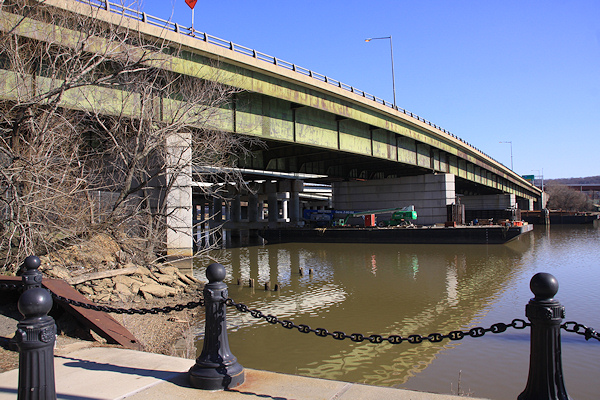 WashCycle says that DPW (? maybe OP?) is holding a meeting on March 28 at 6:30 pm on the concept, though I can't find any press releases or anything about it on dc.gov.
I'll be interested to see how it's proposed to get people up to it from the western shore, given that the approach to the old bridge is supposed to be demolished in order to complete the new 11th Street Local bridge's "arrival" at street level near 11th and O, and then allowing two-way traffic to run on 11th Street by the Navy Yard.
I'm guessing there will be plenty of chatter about this to come!
* On April 1 (well, April 2, technically), the Union Station-Navy Yard Circulator bus starts its summer hours, running from 6 am to 9 pm weekdays and 7 am to 9 pm Saturdays, with extended service on Nationals game days.
* The Southwester reports that there's a Neighborhood Night at Nationals Park on Thursday, April 19. "The team will honor the vibrant spirit of the neighborhood by featuring local residents in various pregame activities, including throwing out the first pitch, delivering the lineup card and greeting the players as they take their positions on the field." Near Southeast and Southwest residents can also get discounted tickets to games throughout the season, but I'll make you follow the link to find out about that!
* The Earth Conservations Corps will be leading volunteers in a cleanup of the wetlands at Diamond Teague Park on April 21, from 9 am to noon, as part of the Anacostia Watershed Society's Earth Day events. (They do want volunteers to register/RSVP in order to participate.)
* A bit farther down the pike, the Kennedy Center is presenting "Look Both Ways: Street Arts Across America," a week-long festival showcasing all manner of free performances and events from May 6-12. One of the May 6 kick-off events will be from 11:30 am to 1:30 pm at Nationals Park and the Fairgrounds (old Bullpen) on Half Street, and the closing event on May 12 from noon to 6 pm will be at the Yards Park.
Comments (7)
More posts:
11th Street Bridges, Fairgrounds/Bullpen, circulator, Earth Conservation Corps, Events, justins, meetings, Stadium Events, Teague Park, The Yards, Yards Park
March 28 Meeting on Potential 11th Street Recreation Bridge
Mar 19, 2012 3:16 PM
 This was mentioned last week when the news first came out, but now there's confirmation via a flyer from the Office of Planning that an "informational meeting" will be held on March 28 at 6:30 pm about the "Potential Recreation Reuse of 11th Street Bridge, SE."
 If you missed the hullabaloo, the city is looking at the notion of reusing the structure of the soon-to-be-abandoned downstream/outbound 11th Street Bridge as a recreation destination, linking both sides of the Anacostia River "in a unique and dramatic way."
And there's also now a page on the OP web site about the project, noting that no decisions have been made or even committted to on the project. The page also makes sure to mention that "actually seeing this project realized will be very ambitious and challenging." A design competition will be held later this year, and apparently the process will "involve local youth in generating ideas." And, as Lydia DePillis noted, there will have to be a "significant level of partnership with the private and non-profit sectors" in order for this to work.
The meeting will be held in the DCRA office space at 1100 4th St., SW. Bring your ideas!
Comments (1)
More posts:
11th Street Bridges, meetings
Could Old Outbound 11th Street Span Become Recreation Bridge?
Mar 12, 2012 12:15 PM
Via TheWashCycle, the city is apparently looking at the concept of transforming the downstream, soon-to-be-abandoned outbound 11th Street Bridge into an "11th Street Recreation Bridge," calling it an "opportunity for a destination linking river trails and recreation amenities." This PDF from the Office of Planning (interestingly, it has the file name "Constituent Request.pdf") has a couple of concept drawings, some graphs about development in the surrounding areas, and keeps mentioning a "proposed design competition" to generate ideas for how the span could be used after the new 11th Street Local Bridge opens this summer.
There's been back-room chatter for a while that Office of Planning director Harriet Tregoning has been interested in preserving one of the existing bridge spans as a potential "High Line" for Washington, DC, and there have also been calls from various residents (including Near Southeast's own Man About Town David Garber) to build some sort of pedestrian bridge linking the two shores of the Anacostia River.
 WashCycle says that DPW (? maybe OP?) is holding a meeting on March 28 at 6:30 pm on the concept, though I can't find any press releases or anything about it on dc.gov.
I'll be interested to see how it's proposed to get people up to it from the western shore, given that the approach to the old bridge is supposed to be demolished in order to complete the new 11th Street Local bridge's "arrival" at street level near 11th and O, and then allowing two-way traffic to run on 11th Street by the Navy Yard.
I'm guessing there will be plenty of chatter about this to come!
Comments (5)
Tuesday Tidbits: Briefer-than-Brief Briefs
Feb 7, 2012 9:26 AM
I'm a bit under the weather these days, so I'll go with a minimalist approach of mostly Tweeted items:
* Lost in the digital piles on my digital desktop was the CapBiz tidbit about a Bang Salon being housed in the new Vida Fitness gym that is supposed to be coming to the neighborhood as part of the Yards' Teeter/Residential project on 4th Street. (As for the "at the Navy Yard" description, I'm pretty sure that this project isn't happening inside the walls of the Washington Navy Yard.) Note that Forest City has yet to officially announce Vida as a tenant for the project, though they sure came close a few weeks back.
* If the neighborhood seems locked down on Wednesday, it's probably because of this little get-together at Nats Park.
* Speaking of the stadium, the Nats have launched "Take Back the Park" to try to head off the Philly Fan Invasion for the May 4-6 games.
* The agenda for ANC 6D's next meeting is out, with the only Near Southeast item being "Half Street Shipping Container Fairgrounds Concept," which according to David Garber will be on the Das Bullpen site at Half and M and is something along the lines of this. Looks hipster-riffic! The meeting is Feb. 13 at 7 pm.
The meeting probably isn't even finished yet, but if you didn't (or did) stop by the first of DDOT's public meetings on their nine-month M Street SE/SW Transportation study, you can browse the presentation slides and take the stakeholder survey, already posted on the new web site for the project.
* Outside the boundaries updates from SWill: Z-Burger is supposed to be opening over yonder today, and a juvenile facility will be moving into that long low gray building on the west side of South Capitol between M and N.
* DDOT tweeted that the 11th Street Local Bridge "is expected to open in late spring." This is the bridge with the pedestrian/cycling path that will run from 11th Street south of N by the Navy Yard into downtown Anacostia.
* The Foundry Lofts are now 70 percent leased.
Comments (5)
More posts:
11th Street Bridges, ANC News, Foundry Lofts/Yards, meetings, Nationals Park, The Yards, Twelve12/Teeter/Yards
M Street Transportation Study Meeting Documents
Jan 12, 2012 8:27 PM
The meeting probably isn't even finished yet, but if you didn't (or did) stop by the first of DDOT's public meetings on their nine-month M Street SE/SW Transportation study, you can browse the presentation slides and take the stakeholder survey, already posted on the new web site for the project.There were a pile of high-powered bloggers and transportation geeks in attendance, so I'm sure there will no shortage of coverage of both this meeting and the entire study that I will happily link to, but there wasn't much news coming out of this first session--it was mainly to introduce the study, talk about the methodology (which you can see in the slides) and then break up into small groups to stand around maps and give feedback about what attendees see as issues that need addressing. (But first, just as at the 2010 meeting, one woman who is particularly anti-bike once again made her feelings known.)
DDOT's representatives say they will be using some 33 other studies that have been done on the area in question as part of this overall study, covering the area from 14th St. SW to 12th Street SE south of the freeway down to the waterfront(s), though that then brought a comment from the audience about when studying is going to stop and there's going to be action.
There will be two more public meetings, one in March-ish and another in June-ish, with the study expected to be completed in August-ish.
Comments (2)
Reminder: M Street SE/SW Transportation Study Meeting Thursday
Jan 11, 2012 9:27 PM
Just a reminder that Thursday night (Jan. 12) is the first public meeting for DDOT's M Street SE/SW Transportation Study, from 6:30 pm to 8:30 pm at Westminster Presbyterian Church at 400 I St., SW.
As the meeting announcement says, "The purpose of the public meeting is to provide an overview of the transportation study, outline the study process/schedule and gather public feedback. Following a brief presentation, attendees will be asked to help identify concerns and issues on maps of the study area and also via a brief survey."
It isn't just about the six lanes on