
|
| |||||||||||||||||||

|
Please note that JDLand is no longer being updated.
peek >>
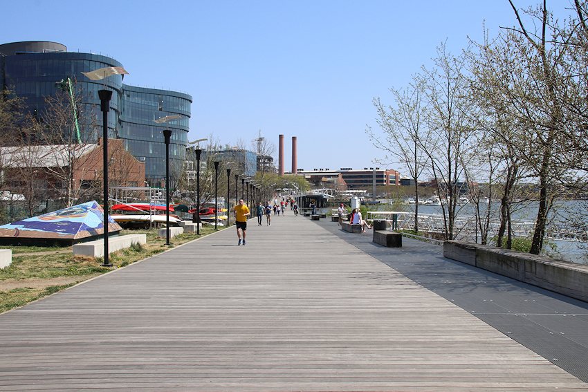
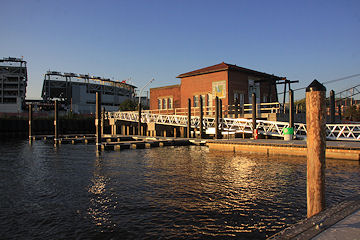
Diamond Teague Park and Piers/Old Capitol Pumphouse
An $8 million 39,000-sq-ft public plaza with water-taxi piers on the Anacostia River across from Nationals Park
Completed in 2009; Named for an Earth Conservation Corps volunteer who was murdered in 2003
- Full Neighborhood Development MapThere's a lot more than just the projects listed here. See the complete map of completed, underway, and proposed projects all across the neighborhood.
- What's New This YearA quick look at what's arrived or been announced since the end of the 2018 baseball season.
- Food Options, Now and Coming SoonThere's now plenty of food options in the neighborhood. Click to see what's here, and what's coming.
![-]()
- Anacostia RiverwalkA bridge between Teague and Yards Parks is part of the planned 20-mile Anacostia Riverwalk multi-use trail along the east and west banks of the Anacostia River.
![-]()
- Virginia Ave. Tunnel ExpansionConstruction underway in 2015 to expand the 106-year-old tunnel to allow for a second track and double-height cars. Expected completion 2018.
![-]()
- Rail and Bus Times
Get real time data for the Navy Yard subway, Circulator, Bikeshare, and bus lines, plus additional transit information. - Rail and Bus Times
Get real time data for the Navy Yard subway, Circulator, Bikeshare, and bus lines, plus additional transit information. - Canal ParkThree-block park on the site of the old Washington Canal. Construction begun in spring 2011, opened Nov. 16, 2012.
![-]()
- Nationals Park21-acre site, 41,000-seat ballpark, construction begun May 2006, Opening Day March 30, 2008.
![-]()
- Washington Navy YardHeadquarters of the Naval District Washington, established in 1799.
![-]()
- Yards Park5.5-acre park on the banks of the Anacostia. First phase completed September 2010.
![-]()
- Van Ness Elementary SchoolDC Public School, closed in 2006, but reopening in stages beginning in 2015.
![-]()
- Agora/Whole Foods336-unit apartment building at 800 New Jersey Ave., SE. Construction begun June 2014, move-ins underway early 2018. Whole Foods expected to open in late 2018.
![-]()
- New Douglass BridgeConstruction underway in early 2018 on the replacement for the current South Capitol Street Bridge. Completion expected in 2021.
![-]()
- 1221 Van290-unit residential building with 26,000 sf retail. Underway late 2015, completed early 2018.

- NAB HQ/AvidianNew headquarters for National Association of Broadcasters, along with a 163-unit condo building. Construction underway early 2017.

- Yards/Parcel O Residential ProjectsThe Bower, a 138-unit condo building by PN Hoffman, and The Guild, a 190-unit rental building by Forest City on the southeast corner of 4th and Tingey. Underway fall 2016, delivery 2018.

- New DC Water HQA wrap-around six-story addition to the existing O Street Pumping Station. Construction underway in 2016, with completion in 2018.

- The Harlow/Square 769N AptsMixed-income rental building with 176 units, including 36 public housing units. Underway early 2017, delivery 2019.

- West Half Residential420-unit project with 65,000 sf retail. Construction underway spring 2017.
![-]()
- Novel South Capitol/2 I St.530ish-unit apartment building in two phases, on old McDonald's site. Construction underway early 2017, completed summer 2019.
![Novel South Capitol]()
- 1250 Half/Envy310 rental units at 1250, 123 condos at Envy, 60,000 square feet of retail. Underway spring 2017.
![-]()
- Parc Riverside Phase II314ish-unit residential building at 1010 Half St., SE, by Toll Bros. Construction underway summer 2017.
![-]()
- 99 M StreetA 224,000-square-foot office building by Skanska for the corner of 1st and M. Underway fall 2015, substantially complete summer 2018. Circa and an unnamed sibling restaurant announced tenants.
![-]()
- The Garrett375-unit rental building at 2nd and I with 13,000 sq ft retail. Construction underway late fall 2017.
![-]()
- Yards/The Estate Apts. and Thompson Hotel270-unit rental building and 227-room Thompson Hotel, with 20,000 sq ft retail total. Construction underway fall 2017.
![-]()
- Meridian on First275-unit residential building, by Paradigm. Construction underway early 2018.
![-]()
- The Maren/71 Potomac264-unit residential building with 12,500 sq ft retail, underway spring 2018. Phase 2 of RiverFront on the Anacostia development.
![-]()
- DC Crossing/Square 696Block bought in 2016 by Tishman Speyer, with plans for 800 apartment units and 44,000 square feet of retail in two phases. Digging underway April 2018.
![DC Crossing]()
- One Hill South Phase 2300ish-unit unnamed sibling building at South Capitol and I. Work underway summer 2018.
![One Hill South Phase 2]()
- New DDOT HQ/250 MNew headquarters for the District Department of Transportation. Underway early 2019.
![New DDOT HQ]()
- 37 L Street Condos11-story, 74-unit condo building west of Half St. Underway early 2019.
![37 L Condos]()
- CSX East Residential/Hotel225ish-unit AC Marriott and two residential buildings planned. Digging underway late summer 2019.
![CSX East Residential/Hotel]()
- 1000 South Capitol Residential224-unit apartment building by Lerner. Underway fall 2019.
![1000 South Capitol Residential]()
- Capper Seniors 2.0Reconstruction of the 160-unit building for low-income seniors that was destroyed by fire in 2018.
![1000 South Capitol Residential]()
- Chemonics HQNew 285,000-sq-ft office building with 14,000 sq ft of retail. Expected delivery 2021.
![1000 South Capitol Residential]()


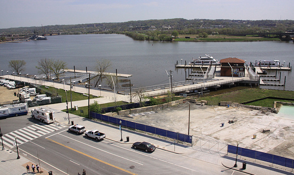
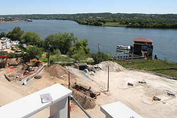
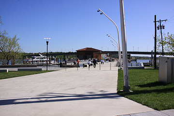
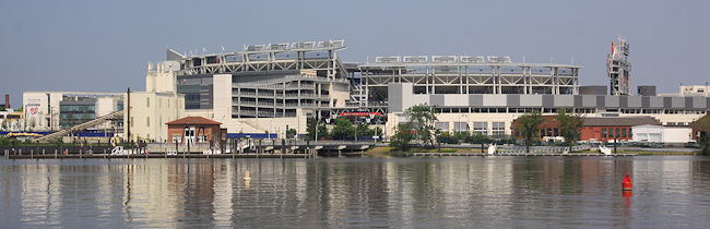
Looking at Diamond Teague Park and the Earth Conservation Corps pumphouse from the viewing platform above Potomac Avenue at Nationals Park. Poplar Point is across the Anacostia, and the Display Ship Barry at far left marks the Navy Yard. The park extends from the pumphouse to the trees at center and then east along the (currently gravel-lined) shoreline; an additional floating pier is seen in the water toward the left. The parking lot at far left is part of the WASA property, some of which will eventually become part of Diamond Teague Park (as well as perhaps an extended portion of Potomac Avenue). The white sandy/gravel-filled area at right behind the red fence is where construction eventually began on the new public plaza as part of the RiverFront redevelopment project. For more photos, see this gallery and this one. (4/5/10) 

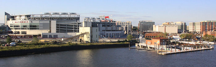
The view from the water taxi pier up toward the ballpark. (8/27/09)
The land-based boardwalk, looking toward the ballpark and the concrete tower at Florida Rock that was eventually demolished. (8/27/09)
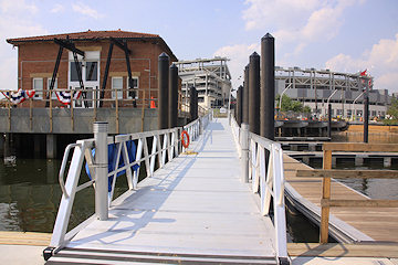
To the right on the way up the gangplank is a view of in-water plantings and the floating boardwalk, with the Yards Park footprint at rear. (8/27/09)
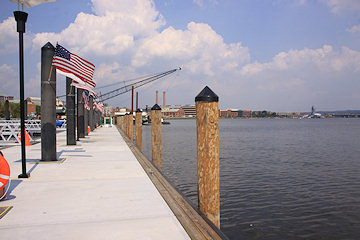
The water taxi pier, with its view of the Navy Yard, the display ship Barry, and the Yards Park. (8/27/09)
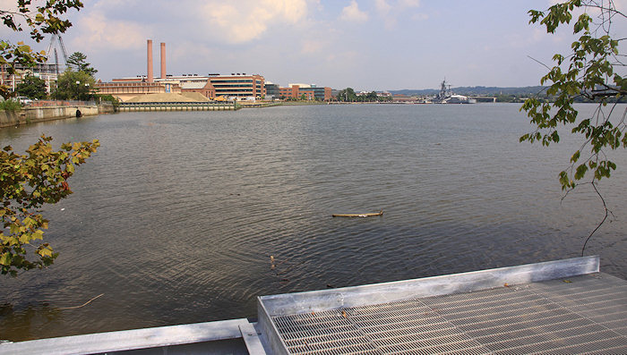
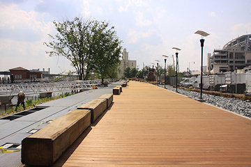
The view of the Anacostia shoreline (and the Yards and the Navy Yard) from the very end of Teague's boardwalk, at least through early 2011. (8/27/09)

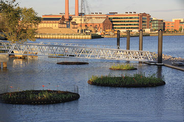
A slightly different angle of same location, with the new 627-foot bridge connecting Teague Park to the Yards Park. (See a gallery of photos of the new bridge.) (11/25/11)
Heading onto the new bridge from Teague Park. (11/25/11)
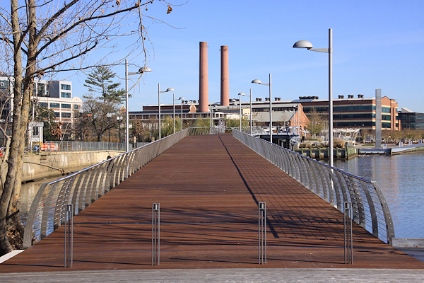
April 14, 2018 - A further-west version of that view toward the bridge, more than six years later, with the new DC Water headquarters now adding to the tableau.
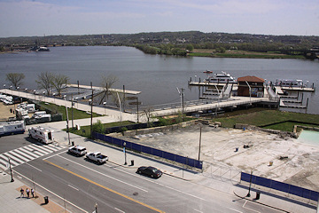
A "before" view of the Diamond Teague Park footprint, as seen from the under-construction ballpark viewing platform, in September 2007. (9/1/07)
Basically the same view, more than two years later, with construction complete. (4/5/10)
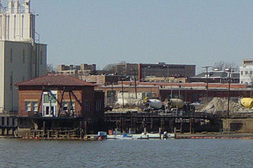
Zooming in to look at the old pumphouse from across the Anacostia River at Poplar Point, in March 2005. (03/05)
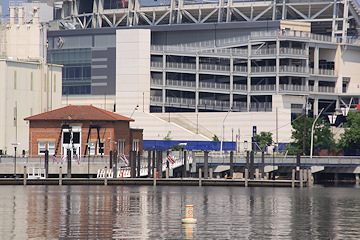
The same view, five years later, with construction completed. (5/31/10)
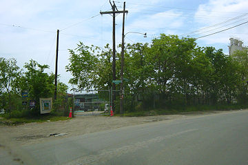
The First Street entry to the ECC property, in May 2003. (05/03)
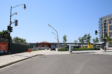
June 4, 2017 - The same location, in June 2017, with construction on the park completed. The expanded intersection of First and Potomac has changed the curbline somewhat.
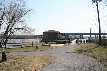
The same location, in April 2010. (4/10/10)
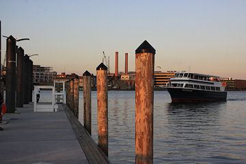
In September 2009, limited water taxi service for some baseball games began between Alexandria's waterfront and Diamond Teague Park. Here the Miss Christin prepares for docking. (9/29/09)
Dusk. (9/29/09)
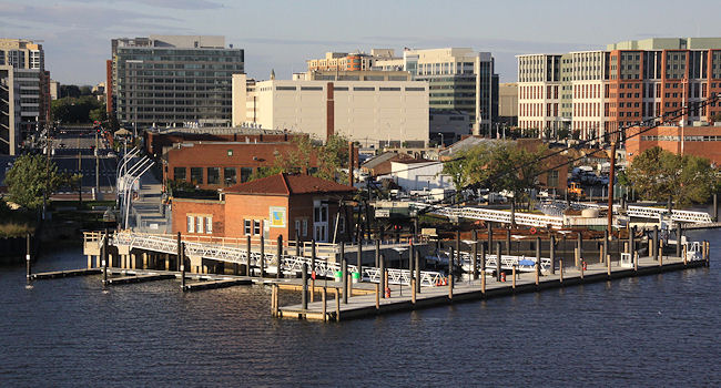
Another view of the piers, from the Douglass Bridge. (9/29/09)
One more view, this time as seen from across the Anacostia River at Poplar Point. (5/31/10)
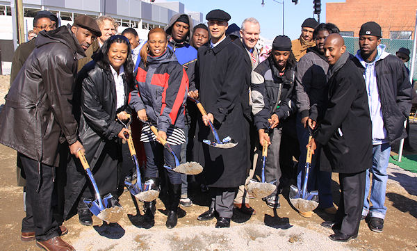
Diamond Teague's parents Ivory and Florence, along with Mayor Fenty, Councilmember Wells, and members of the Earth Conservation Corps, perform the ritual shovel hoisting at the February 2009 groundbreaking ceremony for the park.
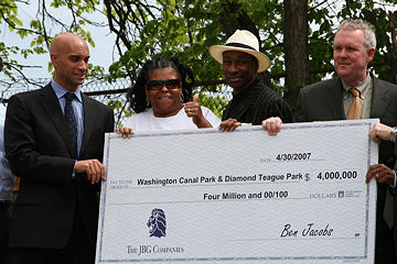
On April 30, 2007, Mayor Fenty, the parents of Diamond Teague, and Ward 6 councilman Tommy Wells accepted a check from the JBG Cos., $1.5 million of which will help fund the creation of Diamond Teague Park (the rest goes to Canal Park). The contribution was required as part of the zoning order that established the Department of Transportation HQ. (see ceremony video from DC16)
Latest News
June 16, 2016
Free Friday Night Fishing Returns to Teague Park
May 2, 2014
To-Do Tidbits: La La La La La Edition
August 21, 2012
Tuesday Tidbits: More Post-Vacation Catching Up to Do
January 9, 2012
Waterfront Photos: Cleared Florida Rock Site and More
November 25, 2011
Yards/Teague Bridge: Let's Try This Again (Sunny Day Version)
November 22, 2011
Yards/Teague Connector Bridge Rainy Opening Day Photos
November 1, 2011
First Look Inside the Foundry Lofts Building at the Yards
October 17, 2011
Tidbits: Truckerboo, Teague/Yards Bridge, Espresso Bar, Red Sox