
|
| |||||||||||||||||||

|
Please note that JDLand is no longer being updated.
peek >>
Near Southeast DC Past News Items: South Capitol St.
|
See JDLand's South Capitol St. Project Page
for Photos, History, and Details |
- Full Neighborhood Development MapThere's a lot more than just the projects listed here. See the complete map of completed, underway, and proposed projects all across the neighborhood.
- What's New This YearA quick look at what's arrived or been announced since the end of the 2018 baseball season.
- Food Options, Now and Coming SoonThere's now plenty of food options in the neighborhood. Click to see what's here, and what's coming.
![-]()
- Anacostia RiverwalkA bridge between Teague and Yards Parks is part of the planned 20-mile Anacostia Riverwalk multi-use trail along the east and west banks of the Anacostia River.
![-]()
- Virginia Ave. Tunnel ExpansionConstruction underway in 2015 to expand the 106-year-old tunnel to allow for a second track and double-height cars. Expected completion 2018.
![-]()
- Rail and Bus Times
Get real time data for the Navy Yard subway, Circulator, Bikeshare, and bus lines, plus additional transit information. - Rail and Bus Times
Get real time data for the Navy Yard subway, Circulator, Bikeshare, and bus lines, plus additional transit information. - Canal ParkThree-block park on the site of the old Washington Canal. Construction begun in spring 2011, opened Nov. 16, 2012.
![-]()
- Nationals Park21-acre site, 41,000-seat ballpark, construction begun May 2006, Opening Day March 30, 2008.
![-]()
- Washington Navy YardHeadquarters of the Naval District Washington, established in 1799.
![-]()
- Yards Park5.5-acre park on the banks of the Anacostia. First phase completed September 2010.
![-]()
- Van Ness Elementary SchoolDC Public School, closed in 2006, but reopening in stages beginning in 2015.
![-]()
- Agora/Whole Foods336-unit apartment building at 800 New Jersey Ave., SE. Construction begun June 2014, move-ins underway early 2018. Whole Foods expected to open in late 2018.
![-]()
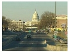
- New Douglass BridgeConstruction underway in early 2018 on the replacement for the current South Capitol Street Bridge. Completion expected in 2021.
![-]()
- 1221 Van290-unit residential building with 26,000 sf retail. Underway late 2015, completed early 2018.

- NAB HQ/AvidianNew headquarters for National Association of Broadcasters, along with a 163-unit condo building. Construction underway early 2017.

- Yards/Parcel O Residential ProjectsThe Bower, a 138-unit condo building by PN Hoffman, and The Guild, a 190-unit rental building by Forest City on the southeast corner of 4th and Tingey. Underway fall 2016, delivery 2018.

- New DC Water HQA wrap-around six-story addition to the existing O Street Pumping Station. Construction underway in 2016, with completion in 2018.

- The Harlow/Square 769N AptsMixed-income rental building with 176 units, including 36 public housing units. Underway early 2017, delivery 2019.

- West Half Residential420-unit project with 65,000 sf retail. Construction underway spring 2017.
![-]()
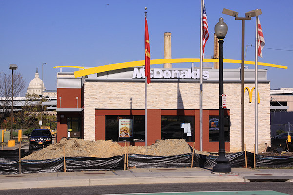
- Novel South Capitol/2 I St.530ish-unit apartment building in two phases, on old McDonald's site. Construction underway early 2017, completed summer 2019.
![Novel South Capitol]()
- 1250 Half/Envy310 rental units at 1250, 123 condos at Envy, 60,000 square feet of retail. Underway spring 2017.
![-]()
- Parc Riverside Phase II314ish-unit residential building at 1010 Half St., SE, by Toll Bros. Construction underway summer 2017.
![-]()
- 99 M StreetA 224,000-square-foot office building by Skanska for the corner of 1st and M. Underway fall 2015, substantially complete summer 2018. Circa and an unnamed sibling restaurant announced tenants.
![-]()
- The Garrett375-unit rental building at 2nd and I with 13,000 sq ft retail. Construction underway late fall 2017.
![-]()
- Yards/The Estate Apts. and Thompson Hotel270-unit rental building and 227-room Thompson Hotel, with 20,000 sq ft retail total. Construction underway fall 2017.
![-]()
- Meridian on First275-unit residential building, by Paradigm. Construction underway early 2018.
![-]()
- The Maren/71 Potomac264-unit residential building with 12,500 sq ft retail, underway spring 2018. Phase 2 of RiverFront on the Anacostia development.
![-]()
- DC Crossing/Square 696Block bought in 2016 by Tishman Speyer, with plans for 800 apartment units and 44,000 square feet of retail in two phases. Digging underway April 2018.
![DC Crossing]()
- One Hill South Phase 2300ish-unit unnamed sibling building at South Capitol and I. Work underway summer 2018.
![One Hill South Phase 2]()
- New DDOT HQ/250 MNew headquarters for the District Department of Transportation. Underway early 2019.
![New DDOT HQ]()
- 37 L Street Condos11-story, 74-unit condo building west of Half St. Underway early 2019.
![37 L Condos]()
- CSX East Residential/Hotel225ish-unit AC Marriott and two residential buildings planned. Digging underway late summer 2019.
![CSX East Residential/Hotel]()
- 1000 South Capitol Residential224-unit apartment building by Lerner. Underway fall 2019.
![1000 South Capitol Residential]()
- Capper Seniors 2.0Reconstruction of the 160-unit building for low-income seniors that was destroyed by fire in 2018.
![1000 South Capitol Residential]()
- Chemonics HQNew 285,000-sq-ft office building with 14,000 sq ft of retail. Expected delivery 2021.
![1000 South Capitol Residential]()


246 Blog Posts Since 2003
Go to Page: 1 | 2 | 3 | 4 | 5 | 6 | 7 | 8 | 9 | 10 ... 25
Search JDLand Blog Posts by Date or Category
Go to Page: 1 | 2 | 3 | 4 | 5 | 6 | 7 | 8 | 9 | 10 ... 25
Search JDLand Blog Posts by Date or Category
 Last week DDOT announced the four teams that have been chosen to advance to the next round and battle it out for the grand prize of being able to design and build the new Douglass Bridge and its approaches as well as reconstruct the Suitland Parkway/I-295 interchange, a prize package worth at least $608 million.
 These four teams will now have the opportunity to respond to DDOT's Request for Proposals on the project, which should be released at some point in the not-too-distant future.
The two reconstruction projects are officially known as Segments 1 and 2 in the two-phase/five-part South Capitol Street Corridor Project, which will also eventually extend the "grand boulevard" feel from a reconfigured M Street intersection north to the Southeast Freeway, build a new on-ramp there, and throw in some streetscape enhancements along New Jersey Avenue as well.
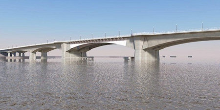 I missed out on a fair amount of discussion of this project last year, including the mayor "announcing the new design" of the bridge that was only marginally different than the design that's been on the boards for a number of years (though the announcement did include a cool video). The announcement was followed by some controversy over the size and necessity of the traffic ovals and even the bridge design itself. (But some cyclists seem okay with it.)
I also didn't get the chance to note that the position of the bridge has undergone some alteration, in that the new bridge's footprint is now designed to run completely parallel to the current bridge, instead of a more diagonal alignment from the original EIS, which you can see compared on pages 11 and 12 of this October 2013 project update.
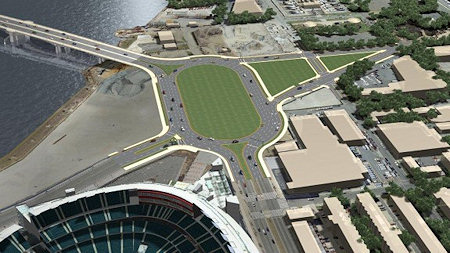 In the fall, both the National Capital Planning Commission and the Commission of Fine Arts looked at the project, with the latter pooh-poohing the "uninspired" bridge design and calling for a the design-build process to come up with a "more innovative proposal" instead of the Memorial Bridge-like arched bascule design that DDOT has chosen. Both commissions are generally supportive of the two ovals, though NCPC's comments after a November review of the project notes that more discussions of the western oval (just southwest of Nationals Park) "will need to occur to help further the ideas of creating a vibrant destination."
While waiting for the RFP to be released and for the designs of the bridge and the ovals to be "refined" for NCPC/CFA approval, you can check out my Douglass Bridge project page, my South Capitol Street page, and the reams of words I've written about both over the years.
|
Comments (2)
More posts:
South Capitol St., Douglass Bridge
|
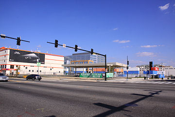 DC property records report that JBG has purchased the former Monument Realty parcels on the northeast corner of South Capitol and N, just north of Nats Parking Lot B.
The property records on this week's sale show the buyer as "1244 South Capitol Residential, LLC," which may be a hint at what JBG has in mind for the site. Bisnow, in quoting JBG's Matt Kelly, says "the firm is 'a probably a year or two from starting anything' at the newly purchased site, and that it could be developed for any number of uses." Bisnow also says JBG paid $17 million for the site.
The main parcel was once home to a BP/Amoco gas station, and five other parcels were undeveloped as well (except for the cutest little yellow building on South Capitol that disappeared about seven years ago).
 Monument and its investment partners (including Lehman Brothers) paid about $10 million for the six lots in multiple transactions in 2005 and 2006, and in 2008 began some initial bureaucratic moves on plans for a residential building that went nowhere. In late 2010, they went to the Zoning Commission with a request to review new plans for a 12-story office building, but that review didn't move forward until mid-2013, and is in fact scheduled to have its final vote in early January. In the meantime, about a year ago Lehman Brothers took full ownership of the site (since it had been the lender on the original loan).
 JBG has just one other property in Near Southeast, but it's a big one: the 1.1 million-square-foot US Department of Transportation headquarters at New Jersey and M, which began construction in 2004 and opened in 2007.
Thanks to many purchases in the Great Ballpark District Land Rush of 2004-06, Monument at one time controlled quite a few properties in the blocks just north of the ballpark. And while the company still owns the old Domino's site on the southeast corner of South Capitol and M, as well as the infamous Half Street hole in the ground, the other properties have since fallen off their inventory, including the recently sold 55 M office building. The company's 50 M site, on the northwest corner of Half and M, was also returned to Lehman Brothers a year ago, and then sold this past May for $13 million to a team mulling a hotel. And at one point Monument had owned the land along N where the southern end of the Fairgrounds now stands, but sold it to Akridge in 2008 during all the fallout of the sale of the Southeastern Bus Garage.
|
Comments (3)
|
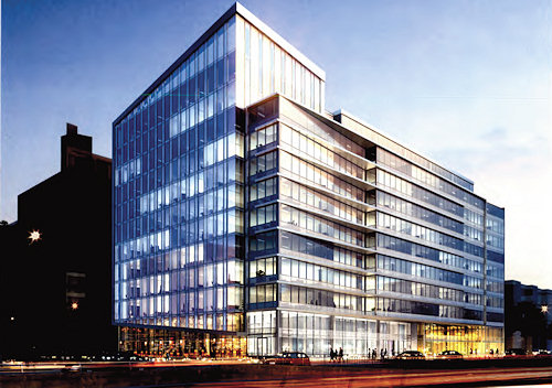
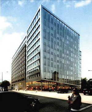
On January 17, the Zoning Commission will be taking up a Capitol Gateway Overlay Review request from Monument Realty for "One M Street," an approximately 328,000-square-foot office building planned for the southeast corner of South Capitol and M streets, SE, on what old-timers know as the old Domino's site, just to the north of the self-storage building.
The building, which is referred to in the zoning submittals as a speculative development, would have a large lobby entrance at the corner of South Capitol and M and somewhere between 9,000 and 17,260 square feet of ground-floor retail, plus four floors of underground parking with 310 spaces. It would be 12 stories high along M Street, but as seen in the above rendering grabbed from the documents, the height along South Capitol would be lower, because of the "different characters" of the two streets. You can see another rendering of the building, as seen from M Street at Van, here.
This has also been referred to the National Capital Planning Commission for review, and ANC 6D will of course be getting a crack at it as well. There's no estimated timeline mentioned in the zoning documents. (But we know how I feel about "estimated" start dates these days anyway. Show me a shovel in the ground!)
Monument has owned the Domino's parcel on the corner since 2005, and added the L-shaped parcel to its east and south in 2008 as part of its settlement with WMATA over not getting the Southeastern Bus Garage site just to the east. Monument, as most people know, built quite a portfolio of land in the blocks just to the north of Nationals Park in 2004 and 2005, having completed 55 M Street in 2009 and still controlling the rest of the land on the east side of Half Street, along with the old Sunoco site on the northeast corner of Half and M and the old BP/Amoco site on the northeast corner of South Capitol and N.
|
Comments (1)
|
Never let it be said that I have completely abandoned my mission. 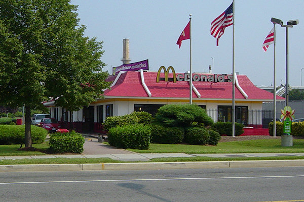
South Capitol and I Streets, SE. At left, August 14, 2005; at right, November 11, 2012.
Thank you, drive through.
|
Comments (3)
|
Clearing out the tidbit hopper:
* Capitol Riverfront and NoMa/H Street are "the District's hottest (read: largest price increases) rental markets," sayeth Delta Associates, with rents having grown by 10.3 percent and 9.0 percent, respectively. (via the Examiner)
* I waited too long to post the tidbit that "rumors are swirling that JBG Companies' plan to sell the 1.35 million square foot Southeast Federal Center have stalled, fueling speculation that the home to the Department of Transportation will be recapitalized," so I have to point you to the Google cache version of the Citybiz post. It's also probably too late to ding both them and originator Real Estate Finance Intelligence for equating the 11-acre DOT HQ site with the entire 55-acre Southeast Federal Center, 44 acres of which is now The Yards.
* I waited even longer to tell you that the Camden South Capitol apartment building across from Nats Park topped off its construction in early June. It's expected to begin leasing in about a year. (SWTLQTC)
* Hey, look, reserved "Nationals Park Parking"! Your choices being the lot nestled next to the Douglass Bridge at 1620 South Capitol or the underground parking lot at 4th and M SW. There's plenty of other choices that are standard cash lots, along with the Nationals' lots. (via WaPo)
* The Fairgrounds is advertising a "First Annual DC Funky Fresh Foodie Fest" on August 25 from 1 to 9 pm. Four live bands, 10 food trucks, the "DC Karaoke Invitational," and more. Unlike its sibling Truckeroo, however, this won't be free, with limited early-bird tickets starting at $42, which includes drinks (the number of drinks depends on whether you buy a regular or premium admission ticket).
|
Comments (0)
More posts:
1325sc, Fairgrounds/Bullpen, US Dept. of Transportation HQ, parking, South Capitol St., Nationals Park
|
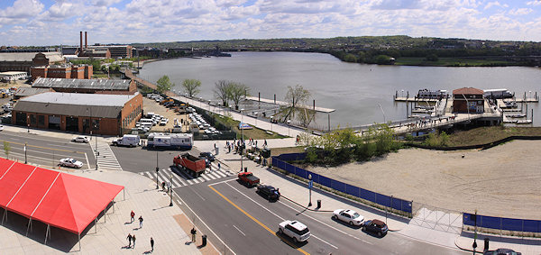
While much of my time on Opening Day each year is spent racing around getting pictures of the festivities, it's equally important to me as the first time after a multi-month lull that I can go to the various viewpoints on the upper deck and get updated photographs of how the ballpark's immediate surroundings have changed.
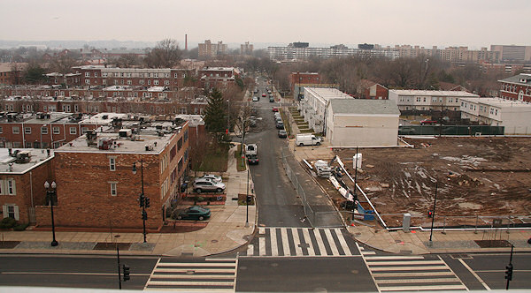
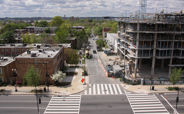
On the ballpark's western side, overlooking South Capitol Street, there's now the Camden South Capitol apartment building rising out of the ground, more than four years after the lot was cleared in preparation for construction. While technically this new 244-unit building is outside of my boundaries, I've taken enough photos of the western side of South Capitol Street over the years to maintain a pseudo-project page, where you can get the basics on the development and some before-and-afters but where I'm not going overboard in documenting the building's arrival. The photos above were taken from the ballpark's northwest viewing platform, and you can see the other images I've taken from that perch since my first visit there in September 2007.
If you want some additional views to the west, I have a series of before-and-afters from the small opening at O Street near the elevators, including these looking straight out O:
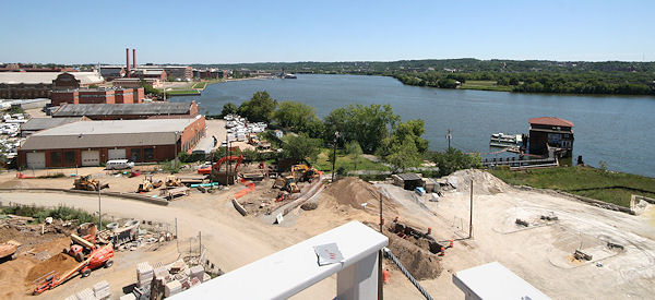
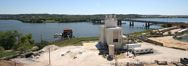
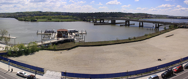
Meanwhile, on the ballpark's south side, there's two changes since last summer worth getting photos of: the completed Riverwalk bridge between Diamond Teague Park and the Yards Park, and the clearing of the Florida Rock site. And, since my 2007 "before" shots are from the time that Potomac Avenue and First Street were being reconstructed, and long before the waterfront started getting spiffed up, the transformation is pretty striking, though you can tell that I had my wide-angle lens in 2007 but had to settle for stitched-together images this time:
You can browse my many variations of these before-and-after Anacostia River views, both to the southeast and to the southwest. And, note at the top of these pages the links to other "on high" photographs from various rooftops around the neighborhood.
(PS: Apologies for the site's extended outage on Thursday--a botched move by my hosting company to upgrade the hardware of my shared server resulted in what to you was a nearly seven-hour outage but to me was the equivalent of a couple of ice ages.)
|
Comments (0)
|
I've tried over the past few months to clampdown on runaway Tidbits posts, but these are some pretty small tidbits, so I think I'll let them through: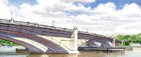 * Douglass Bridge: The Feds have "freed up" $68 million from previously appropriate funds to allow DC to start buying up right-of-way land for the new South Capitol Street/Douglass Bridge. NBC4 quotes DDOT chief Terry Bellamy as saying "If I had my way and we had the money, we could possibly see a new bridge in about six to seven years." But, considering they're looking for $800 million for not just the bridge itself but all the associated improvements to South Capitol Street and its interchanges with I-395 and I-295, getting the rest of the money might be a little trickier.
 * DPW Move: While the timeline for getting DPW into their new home on Okie St. NE and out of their New Jersey and K site has slipped (shocker!), things are still moving forward, and I'm hearing that they should be moved early in 2012. But this delay is not as yet impacting William C. Smith's plans for a new apartment building just to the north--various permits have recently been approved, and WCS expects to start some deep infrastructure work, along with some clearing and grading along New Jersey Avenue north of I, sometime in December. (But WCS needs DPW out before too long because a smidge of DPW land crosses what will eventually be the new I Street and onto the WCS property.)
* Douglass Bridge: The Feds have "freed up" $68 million from previously appropriate funds to allow DC to start buying up right-of-way land for the new South Capitol Street/Douglass Bridge. NBC4 quotes DDOT chief Terry Bellamy as saying "If I had my way and we had the money, we could possibly see a new bridge in about six to seven years." But, considering they're looking for $800 million for not just the bridge itself but all the associated improvements to South Capitol Street and its interchanges with I-395 and I-295, getting the rest of the money might be a little trickier.* Half Street: According to the Post, Monument Realty and investment partner Victor MacFarlane "are now thinking about when to begin" developing the rest of their Half Street project. The southern portion of Monument's side of Half Street (the east side--you know, where the big hole in the ground is) was originally designed with both a hotel and a residential building. And there's still no word from Akridge on a start date for their side of Half Street (the Bullpen side).
* DPW Move: While the timeline for getting DPW into their new home on Okie St. NE and out of their New Jersey and K site has slipped (shocker!), things are still moving forward, and I'm hearing that they should be moved early in 2012. But this delay is not as yet impacting William C. Smith's plans for a new apartment building just to the north--various permits have recently been approved, and WCS expects to start some deep infrastructure work, along with some clearing and grading along New Jersey Avenue north of I, sometime in December. (But WCS needs DPW out before too long because a smidge of DPW land crosses what will eventually be the new I Street and onto the WCS property.)* Wha?: Is it just me, or does this article seem like it was written in 2009? It's a bit odd to trot out version 83 of the "there's no food in Near Southeast" story when there are leases signed for at least 10 new eateries to open in the next 12 months: Lot 38 Espresso at the old Little Red Building site (Any Minute Now!), Potbelly and Kruba Thai in the Foundry Lofts by spring, the Park Tavern at Canal Park by summer, and six choices at the Boilermaker Shops by the end of 2012. Not to mention probably another couple places in the Lumber Shed, perhaps a big one at 100 M, and a Harris Teeter in 2013. But I still predict that, when the slew of What's Happening Around Nationals Park stories come pouring out in advance of Opening Day 2012, the focus will still be on the lack of movement along Half Street (see Tidbit #1).
* New Bridge: Don't forget the dedication ceremony for the Yards/Teague bridge on Tuesday at 1:30 pm on the Yards Park side of the bridge. In addition to the mayor and DC Water chief George Hawkins, the organizers are also expecting Eleanor Holmes Norton, Naval District Washington Commandant Rear Admiral Patrick Lorge, USDOT deputy secretary John Porcari--and the Racing Presidents!
|
Comments (5)
More posts:
880 NJ/Park Chelsea, Trash Transfer Site/DPW, Restaurants/Nightlife, Monument Valley/Half St., South Capitol St., Douglass Bridge, WC Smith/Square 737, The Yards, Yards Park
|
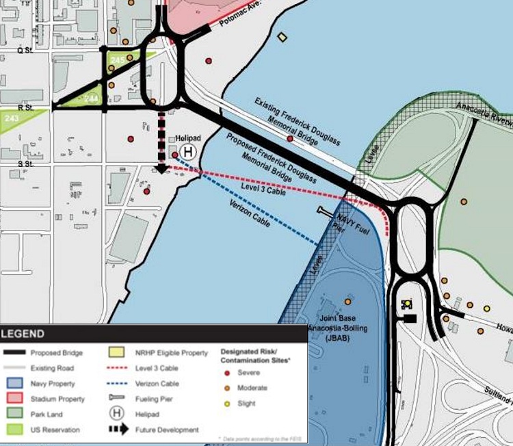
Just sent out by DDOT: "Today the District Department of Transportation (DDOT) announced the start of land acquisition and preliminary design work for the South Capitol Street Project, which includes replacement of the current Frederick Douglass Memorial Bridge. [...] While the Record of Decision (ROD) is still pending, the Federal Highway Administration signed the project's Final Environmental Impact Statement (FEIS) following the requisite 30-day public comment period that ended in May."
I'm posting quickly, so I shall now crib unabashedly from my post on the Final EIS, from back in April:
If you are interested in this subject, there is more verbiage and documentation accompanying the plans than you could ever dream of. (Traffic studies! Environmental consequences! Technical reports!) And I've written a lot about the process, which began more than a decade ago with other studies before the EIS got underway. And I'm sure there will be posts on other blogs delving more specifically into portions of the plans. But, since most people probably want to know "what does this mean for me?", you can see this graphic (from the 224-MB chapter 2 of the FEIS) giving a quick overview of what changes are planned along South Capitol Street if the final EIS is signed off on (and, more importantly, if funding is secured). The short version, for the west side of the Anacostia:
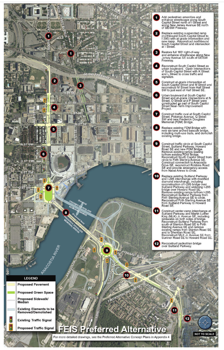 * Add "pedestrian amenities" and enhance the streetcape along South Capitol north of I and along New Jersey Avenue SE north of the freeway.
* Add "pedestrian amenities" and enhance the streetcape along South Capitol north of I and along New Jersey Avenue SE north of the freeway.
* Replace the existing ramp to the freeway from South Capitol and I with an at-grade intersection. (This would be a left turn onto a ramp to the freeway from under the freeway, near the current Nats HH economy parking lot.)
* Bring New Jersey Avenue SE back to a 160-foot full right-of-way, and add streetscape enhancements.
* "Reconstruct South Capitol Street as an urban boulevard." This means bringing M Street up to an "at-grade" intersection (no more tunnel), and would include new signalized at-grade intersections to allow traffic to cross South Capitol on K and L streets. (M Street would also get reconstructed between the Halfs [SE and SW].) The section of South Capitol north of M would have the same streetscape that the south portion received during its 2007/08 makeover, with wide sidewalks and a tree-lined median.
* Build a traffic oval at South Capitol, Potomac, Q, as the gateway to a new arched bascule-design Douglass Bridge that would have wide "multi-use trails" (i.e., sidewalks!) in both directions. The existing bridge would be demolished, after the new bridge is built somewhat downriver of the current location.
The Executive Summary (220 MB PDF) gives a good overview of the FEIS and preferred alternative (as it should!), but I also suggest wandering through the Chapter 2: Alternatives section, especially if you came to the neighborhood or JDLand after 2008 and didn't get to follow along during the EIS process, or if you're interested in the additional plans for east of the river, which I'm going to leave to others to discuss. My previous posts on all of this may be of interest as well. If you're wanting to see some of the earlier studies referenced in the FEIS, there are links to them at the top of my South Capitol Street project page.
How much would this all cost? The preferred alternative is priced in this final EIS at $806 million in FY 2014 dollars. (New bridges are expensive, you know.) Note that nothing in today's statement from DDOT says anything about funding, or a construction timeline.
You can also check my South Capitol Street and South Capitol Street Bridge page for all the info about the plans, along with my scores of posts over the past few years.
|
Comments (6)
More posts:
South Capitol St., Douglass Bridge, Traffic Issues
|
News and notes, some already Tweeted, some not:
* Don't forget the two public meetings on the Final Environmental Impact Statement for South Capitol Street. The first one is tonight (April 26) at Amidon-Bowen Elementary School at 4th and I, SW, from 6:30 to 8:30 pm. The second one is Thursday (April 28), at Savoy Elementary School, 2400 Shannon Place, SE, also from 6:30 to 8:30 pm. My entry from a few days ago gives the rundown on what changes they are looking at to transform South Capitol Street into a "grand boulevard" rather than a commuter speedway.
* ANC 6B commissioner Norm Metzger passes along an update from fellow 6B'er Kirsten Oldenberg on the status of the Marines' search for a new barracks site. A quote: "Now in progress are Installation Master Planning and Support Studies and a Financial Feasibility Analysis. We were only given a brief outline of this work, which will not be made public. A briefing on this 'conceptual' material will be given to the Commandant of the Marine Corps sometime in late May (perhaps). Then once he makes whatever decisions are necessary, work will proceed on putting together the guts of an RFP. This information has to go to various 'stakeholders' and ultimately Congress before the RFP can be finalized and released. One of the developers at the meeting today tried to pin officials down regarding timelines but it proved difficult to do. Bottom line, if all goes smoothly (which is doubtful), a site and developer could be chosen by Fall 2012. (Don't bet on it.)"
* Dan Steinberg writes at his DCSportsBog today about how the Nats went from fireworks to a submarine horn: "A few months ago, when people inside the organization began considering a move away from fireworks, they began researching naval horn options and even went to the Navy Yard to check out alternatives. Their advisers at the Yard advised they go with the sub horn, both for the sound and for the way that sound would carry. The Navy folks also thought the three-blast signal would be appropriate. So the horn was taken to Nats Park and hooked up to a special mic in the press box, where members of the marketing department can fire away after home runs and wins." Nats COO Andy Feffer says that the distinctive sound should make people immediately think "Nationals Park": "'The military is already part of game presentation and the Navy Yard is right next door; not only is it unique and distinctive, but it fit. It fit with our goals, and it fits with what Washington is. It's ours. Someone else can't copy it and say we're gonna do that too. It's Washington's.'"
* In a subscrbers-only piece in last week's Washington Business Journal, the story of Red Hot & Blue's departure from Nationals Park after the inaugural 2008 season gets a bit, ahem, spicier. Five months into that first season, the BBQ outlet told the Nats it was no longer interested in being at the ballpark. "Hold it, says the team, Red, Hot & Blue was still on the hook for $235,000 in regular payments until the end of the 2009 season, still yet to be paid, according to a breach of contract suit that was filed in March in D.C. Superior Court."
* Honda put out a photo gallery of the new 2012 Honda Civic, which includes a number of shots taken at the Yards Park, as well as Anacostia Park and other DC locations. (You have to wander through a bit to find them, but they are pretty neat to see.)
|
Comments (2)
|
It's been so long since I've written about this that I forgot it was even still in progress, but DDOT has announced two public meetings to present the "preferred alternative" and the Final Environmental Impact Statement for the South Capitol Street Corridor, first on April 26 at Amidon-Bowen Elementary School in SW and then two days later at Savoy Elementary School in SE. This is the long-term study of how to improve South Capitol Street on both sides of the Anacostia River to better address safety, traffic, pedestrian, and streetscape issues, and includes the construction of a new Frederick Douglass Bridge.* Add "pedestrian amenities" and enhance the streetcape along South Capitol north of I and along New Jersey Avenue SE north of the freeway.
If you are interested in this subject, there is more verbiage and documentation accompanying the plans than you could ever dream of. (Traffic studies! Environmental consequences! Technical reports!) And I've written a lot about the process, which began more than a decade ago with other studies before the EIS got underway. And I'm sure there will be posts on other blogs delving more specifically into portions of the plans. But, since most people probably want to know "what does this mean for me?", you can see this graphic (from the 224-MB chapter 2 of the FEIS) giving a quick overview of what changes are planned along South Capitol Street if the final EIS is signed off on (and, more importantly, if funding is secured). The short version, for the west side of the Anacostia:
* Add "pedestrian amenities" and enhance the streetcape along South Capitol north of I and along New Jersey Avenue SE north of the freeway.* Replace the existing ramp to the freeway from South Capitol and I with an at-grade intersection. (This would be a left turn onto a ramp to the freeway from under the freeway, near the current Nats HH economy parking lot.)
* Bring New Jersey Avenue SE back to a 160-foot full right-of-way, and add streetscape enhancements.
* "Reconstruct South Capitol Street as an urban boulevard." This means bringing M Street up to an "at-grade" intersection (no more tunnel), and would include new signalized at-grade intersections to allow traffic to cross South Capitol on K and L streets. (M Street would also get reconstructed between the Halfs [SE and SW].) The section of South Capitol north of M would have the same streetscape that the south portion received during its 2007/08 makeover, with wide sidewalks and a tree-lined median.
* Build a traffic oval at South Capitol, Potomac, Q, as the gateway to a new arched bascule-design Douglass Bridge that would have wide "multi-use trails" (i.e., sidewalks!) in both directions. The existing bridge would be demolished, after the new bridge is built somewhat downriver of the current location.
The Executive Summary (220 MB PDF) gives a good overview of the FEIS and preferred alternative (as it should!), but I also suggest wandering through the Chapter 2: Alternatives section, especially if you came to the neighborhood or JDLand after 2008 and didn't get to follow along during the EIS process, or if you're interested in the additional plans for east of the river, which I'm going to leave to others to discuss. My previous posts on all of this may be of interest as well. If you're wanting to see some of the earlier studies referenced in the FEIS, there are links to them at the top of my South Capitol Street project page.
How much would this all cost? The preferred alternative is priced in this final EIS at $806 million (not billion! yeesh) in FY 2014 dollars. (New bridges are expensive, you know.)
(I know that this is a very quick overview of a big study and plan, but there will be plenty of time to talk more about it, especially with the upcoming public meetings.)
|
Comments (1)
|
246 Posts:
Go to Page: 1 | 2 | 3 | 4 | 5 | 6 | 7 | 8 | 9 | 10 ... 25
Search JDLand Blog Posts by Date or Category
Go to Page: 1 | 2 | 3 | 4 | 5 | 6 | 7 | 8 | 9 | 10 ... 25
Search JDLand Blog Posts by Date or Category