
|
| |||||||||||||||||||

|
Please note that JDLand is no longer being updated.
peek >>
Near Southeast DC Past News Items
- Full Neighborhood Development MapThere's a lot more than just the projects listed here. See the complete map of completed, underway, and proposed projects all across the neighborhood.
- What's New This YearA quick look at what's arrived or been announced since the end of the 2018 baseball season.
- Food Options, Now and Coming SoonThere's now plenty of food options in the neighborhood. Click to see what's here, and what's coming.
![-]()
- Anacostia RiverwalkA bridge between Teague and Yards Parks is part of the planned 20-mile Anacostia Riverwalk multi-use trail along the east and west banks of the Anacostia River.
![-]()
- Virginia Ave. Tunnel ExpansionConstruction underway in 2015 to expand the 106-year-old tunnel to allow for a second track and double-height cars. Expected completion 2018.
![-]()
- Rail and Bus Times
Get real time data for the Navy Yard subway, Circulator, Bikeshare, and bus lines, plus additional transit information. - Rail and Bus Times
Get real time data for the Navy Yard subway, Circulator, Bikeshare, and bus lines, plus additional transit information. - Canal ParkThree-block park on the site of the old Washington Canal. Construction begun in spring 2011, opened Nov. 16, 2012.
![-]()
- Nationals Park21-acre site, 41,000-seat ballpark, construction begun May 2006, Opening Day March 30, 2008.
![-]()
- Washington Navy YardHeadquarters of the Naval District Washington, established in 1799.
![-]()
- Yards Park5.5-acre park on the banks of the Anacostia. First phase completed September 2010.
![-]()
- Van Ness Elementary SchoolDC Public School, closed in 2006, but reopening in stages beginning in 2015.
![-]()
- Agora/Whole Foods336-unit apartment building at 800 New Jersey Ave., SE. Construction begun June 2014, move-ins underway early 2018. Whole Foods expected to open in late 2018.
![-]()
- New Douglass BridgeConstruction underway in early 2018 on the replacement for the current South Capitol Street Bridge. Completion expected in 2021.
![-]()
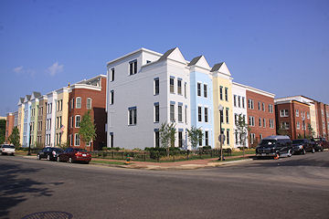
- 1221 Van290-unit residential building with 26,000 sf retail. Underway late 2015, completed early 2018.

- NAB HQ/AvidianNew headquarters for National Association of Broadcasters, along with a 163-unit condo building. Construction underway early 2017.

- Yards/Parcel O Residential ProjectsThe Bower, a 138-unit condo building by PN Hoffman, and The Guild, a 190-unit rental building by Forest City on the southeast corner of 4th and Tingey. Underway fall 2016, delivery 2018.

- New DC Water HQA wrap-around six-story addition to the existing O Street Pumping Station. Construction underway in 2016, with completion in 2018.

- The Harlow/Square 769N AptsMixed-income rental building with 176 units, including 36 public housing units. Underway early 2017, delivery 2019.

- West Half Residential420-unit project with 65,000 sf retail. Construction underway spring 2017.
![-]()
- Novel South Capitol/2 I St.530ish-unit apartment building in two phases, on old McDonald's site. Construction underway early 2017, completed summer 2019.
![Novel South Capitol]()
- 1250 Half/Envy310 rental units at 1250, 123 condos at Envy, 60,000 square feet of retail. Underway spring 2017.
![-]()
- Parc Riverside Phase II314ish-unit residential building at 1010 Half St., SE, by Toll Bros. Construction underway summer 2017.
![-]()
- 99 M StreetA 224,000-square-foot office building by Skanska for the corner of 1st and M. Underway fall 2015, substantially complete summer 2018. Circa and an unnamed sibling restaurant announced tenants.
![-]()
- The Garrett375-unit rental building at 2nd and I with 13,000 sq ft retail. Construction underway late fall 2017.
![-]()
- Yards/The Estate Apts. and Thompson Hotel270-unit rental building and 227-room Thompson Hotel, with 20,000 sq ft retail total. Construction underway fall 2017.
![-]()
- Meridian on First275-unit residential building, by Paradigm. Construction underway early 2018.
![-]()
- The Maren/71 Potomac264-unit residential building with 12,500 sq ft retail, underway spring 2018. Phase 2 of RiverFront on the Anacostia development.
![-]()
- DC Crossing/Square 696Block bought in 2016 by Tishman Speyer, with plans for 800 apartment units and 44,000 square feet of retail in two phases. Digging underway April 2018.
![DC Crossing]()
- One Hill South Phase 2300ish-unit unnamed sibling building at South Capitol and I. Work underway summer 2018.
![One Hill South Phase 2]()
- New DDOT HQ/250 MNew headquarters for the District Department of Transportation. Underway early 2019.
![New DDOT HQ]()
- 37 L Street Condos11-story, 74-unit condo building west of Half St. Underway early 2019.
![37 L Condos]()
- CSX East Residential/Hotel225ish-unit AC Marriott and two residential buildings planned. Digging underway late summer 2019.
![CSX East Residential/Hotel]()
- 1000 South Capitol Residential224-unit apartment building by Lerner. Underway fall 2019.
![1000 South Capitol Residential]()
- Capper Seniors 2.0Reconstruction of the 160-unit building for low-income seniors that was destroyed by fire in 2018.
![1000 South Capitol Residential]()
- Chemonics HQNew 285,000-sq-ft office building with 14,000 sq ft of retail. Expected delivery 2021.
![1000 South Capitol Residential]()


2212 Blog Posts Since 2003
Go to Page: 1 | ... 26 | 27 | 28 | 29 | 30 | 31 | 32 | 33 | 34 ... 222
Search JDLand Blog Posts by Date or Category
Go to Page: 1 | ... 26 | 27 | 28 | 29 | 30 | 31 | 32 | 33 | 34 ... 222
Search JDLand Blog Posts by Date or Category
 Considering what it portended for the forgotten little patch of land I had been blogging about for the previous 20 months, this post of mine late in the evening on Sept. 21, 2004 was pretty understated: "Baseball coming to Near Southeast? 'District officials disclosed plans yesterday to build a publicly financed stadium costing more than $400 million on the Anacostia waterfront near South Capitol Street, amid growing signs that Major League Baseball will attempt to move the Montreal Expos to Washington.' It doesn't mean that baseball in DC is a done deal, or that the Near Southeast site is a done deal, but it's a very interesting decision, and one that would have a huge impact on Near Southeast if it were to happen."
 Yeah, kind of!
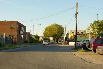
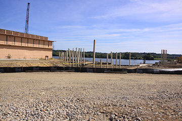
 Late the next day, I went out and took a set of photos throughout the 21 acres that would eventually become home to Nationals Park, knowing it was important to get a bunch of "before" photos should this stadium actually come to pass. This was in the days when my photo-taking was pretty much limited to firing my little point-and-shoot digital camera from behind the wheel while I drove around the neighborhood, having not quite yet worked up the bravery to get out on foot. (Eventually I documented all of the buildings that were demolished to make way for the ballpark, but this Sept. 22 excursion marks for me official start of what would become an all-consuming project for me over the next four years.)
It wasn't until the next week that it was all made official, that the Expos were coming to town and that the city would pursue building a new stadium in Near Southeast. And the reality of the ballpark didn't truly come to pass until that marathon city council session in February 2006 that first voted down then finally ratified the stadium lease agreement (signed by MLB the next month), followed two days later by the court ruling allowing the eminent domain seizure of the land for the ballpark to move forward. Demolitions began in May 2006, and the construction was completed on time for the official opener on March 30, 2008.
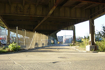 To look at not only the Sept. 22 ballpark-area photos but also a batch I took mainly around the Cappers footprint a few days earlier is to be reminded yet again of how much change has come to this area in the same amount of time that many people, say, pay off a new car. It's almost jarring to catch glimpses in these shots of the old South Capitol Street viaduct (demolished in July 2007) that in many ways was such a symbol of the old Near Southeast--how it walled the neighborhood off from Southwest, and how it helped perpetuate the area's overgrown industrial feeling, while allowing commuters to blow past it all without really having to look at it.
It's going to be a while before big-time development resumes in the area (just like everywhere else in the city/region/country), but that doesn't make the changes that have already happened to this formerly forgotten little spot a mile south of the U.S. Capitol any less striking to look at.
|
Comments (0)
|
Even at my laziest, it's hard to not pull out my camera on a day like today and head to the Hood. But without a lot of projects going on, I had the chance to also wander by some locations I've not paid as much attention to as I should. Here's the highlights: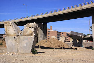 I stopped by 11th and 12th streets to get caught up on the RFK ramp demolition that's part of the 11th Street Bridges project. The ramps across M have been down for a while now, making M Street along this stretch seem slightly less claustrophobic. The remaining concrete pillars (like the one at left, and the stubs on the south side of M) make for some interesting sculptures.
 I even ventured down to the fences at the Park at the Yards to see what I could see, and on the west side of the footprint I could glimpse some of the work being done on the Canal Basin water feature at the foot of Third Street as well as some clearing of the area that will be the Great Lawn. Here's the latest photos, or check the Yards Park page to see some of them matched with the renderings of what the spots will look like.
I stopped by 11th and 12th streets to get caught up on the RFK ramp demolition that's part of the 11th Street Bridges project. The ramps across M have been down for a while now, making M Street along this stretch seem slightly less claustrophobic. The remaining concrete pillars (like the one at left, and the stubs on the south side of M) make for some interesting sculptures.
Capitol Quarter continues to progress on its third block (between K, I, Fifth, and Fourth), with some houses now bricked and framing coming soon to the north side of the block, making St. Paul's church not look quite so lonely anymore. Plus, the first foundations are being poured on the fourth and final block of phase 1, along Virginia Avenue between Third and Fourth.
I even ventured down to the fences at the Park at the Yards to see what I could see, and on the west side of the footprint I could glimpse some of the work being done on the Canal Basin water feature at the foot of Third Street as well as some clearing of the area that will be the Great Lawn. Here's the latest photos, or check the Yards Park page to see some of them matched with the renderings of what the spots will look like.
This isn't the most earth-shattering shot of the day, but I did feel it necessary to finally get a shot of 900 M Street now that Domino's is open.

Last but not least, I wandered around Virginia Avenue Park, finally getting my set of "baseline" photos along Ninth Street (only six years later than I should have). I also took some photos of the park itself but I'm going to take a little more time and not do a rush-job on the park photos; the one above, of the community garden, will have to tide you over a little longer.
As always, on any of these pages, click on the  icon to see a complete set of before-and-afters of the location you're viewing. (And boy, am I loving being able to post larger thumbnails of photos here in the blog entries, thanks to the redesign of the home page. But don't forget to click through to see the non-thumbnailed versions.)
icon to see a complete set of before-and-afters of the location you're viewing. (And boy, am I loving being able to post larger thumbnails of photos here in the blog entries, thanks to the redesign of the home page. But don't forget to click through to see the non-thumbnailed versions.) |
Comments (0)
More posts:
11th Street Bridges, 900m, Capper, Capitol Quarter, 8th Street, Virginia Ave Park, The Yards, Yards Park
|
If you're actually reading this post on the JDLand home page rather than in your feeds or via e-mail, you're probably noticing that the home page looks a little different this afternoon. After many months (years!) of trying to figure out how to make it not quite so much of an assault on the senses, I finally decided that it's time to move the big ole' development map off the home page.
It was important to have the map back when almost no one had a familiarity with this strange neighborhood known as Near Southeast, but now that the pace of change has slowed considerably, I think it's less necessary to be smacked with that graphic every time one visits the site. You can still reach the map and the tabs with the various projects broken out by type by clicking on the DC-with-an-arrow icon at right; and I've listed a few "Active Projects" to allow quick access to developments that are currently underway or of high interest.
Getting rid of the map also allowed me to make the blog part of the home page much wider, with bigger type, and I think everyone will agree it's now far easier to read. Plus, the Events Calendar is now "above the fold" (as we say in the newspaper biz). I was also able to enlarge the random before-and-after photos that appear at the top of the page, too, which I think is a nice change.
I know some people will be unhappy about the relegation of the map to inside-the-site status, but I do think that, for the next little while, this is a better way to go. As I'm nearing the end of my seventh year running this site, I've got to do *something* to make it fresh to my eyes every so often!
(And you guys even get a bigger box to type your comments in. Everyone's a winner.)
|
Comments (0)
More posts:
JDLand stuff
|
A reminder that on Monday (Sept. 21) the Zoning Commission will be hearing a request from Forest City for a text amendment to the Southeast Federal Center Overlay that would "authorize a Trapeze School and Aerial Performing Arts Center in the SEFC/R-5-E Zone District at the Yards." This is the Trapeze School New York, which left Baltimore's Inner Harbor earlier this year and is currently flying through the air on the old DC Convention Center site at Ninth and H, NW. The school would take up residence on the lot on the southeast corner of Fourth and Tingey ("Parcel O"), which someday will be a residential building but is not expected to be developed anytime soon. It's also just north of the site of the Park at the Yards, which is scheduled to open next year.
Here's the report prepared by the Office of Planning in advance of Monday's hearing, in which they recommend approval of the four text amendments being sought. They're asking for the trapeze school to be allowed for five years (or longer, via a special expection), and to dispense with the off-street parking requirement, since there's already so much surface parking at the Yards. There's also some technical needs to actually create tax parcel lots on the site to allow for the issuance of building permits.
The hearing is at 6:30 pm at 441 4th St., NW (Suite 220 South), or you can watch the live feed or wait for the video on demand (it gives me a smile just to type that--I've waited for video on demand for zoning hearings for so long!)
|
Comments (0)
|
Here's a bunch of small items that I've Tweeted over the past few days; I'm succumbing to abject laziness and only barely bothering to rewrite them (who needs all those extra words, anyway?):
* RT @TWTSports: #Nats will open the 2010 season at Nationals Park against the Phillies on April 5. [schedule link]
* RT @LPags03: #Nats host BOS for exhibition game on 4/3.
* The new Canal Park design is on the preliminary agenda for the Oct. 1 NCPC meeting. Hope it makes the final agenda: link
* Study of commuter ferry service to waterfront from Woodbridge pegs a $30M price tag just for needed improvements: link
* From @octolabs: DC Citywide Data Warehouse won coolest gov innovation award for DC Data Catalog/Data Feeds: link [and thanks for the shout-out!]
* RT @Cornercopia: Owner of blue civic with Maryland plates parked in front should probably move their car. 2 tickets already since Mon.
|
Comments (0)
|
I think I mentioned this a few days back, but here it is again: On Saturday (Sept. 19) from 10 am to 2 pm, the BID is hosting a Canal Park Picnic and Home Tour: "Enjoy live music, food, drink, and lawn games at Canal Park! Tour selected rowhouses, condos, apartments and townhouses of residents in the new Capitol Riverfront neighborhood. See what it's like to live in the Front!" It's free and open to the public. Food will be provided by Cornercopia, "Smokin' Somethin'" (BBQ) and Sweetgreen (frozen yogurt). The two 45-minute neighborhood walking tours start at 10:30 am and 12:30 pm.This also seems to be somewhat in place of a Capitol Riverfront WalkingTown DC tour, since there isn't one on WalkingTown's fall lineup this weekend. My bad--I didn't see the "FRONT" tour on the WalkingTownDC lineup.
|
Comments (0)
More posts:
Capitol Riverfront BID, Canal Park
|
After seeing the raze permit approval earlier this week for 156 L Street, the former Star Market (aka the "Little Red Building"), I contacted the building's owner for an update on his plans. Mr. Park (whose father used to own Bernstein's Liquors at Half and M SW) says that his plans are now to build just a liquor store; previous plans to include a second-floor deli have been set aside. He's hoping to get a building permit for a new structure within the next month or so, and expects construction to take about five months. So possibly the store could open next spring, though hopefully readers are becoming suitably cautious when hearing development timelines.
I know neighbors at CHT and the Marriott have been working on agreements with the store, but I haven't heard where they stand; anyone in the know please give everyone the scoop, in the comments. And keep an eye out for demolition of the old building, which should take about 10 minutes once it starts.
|
Comments (0)
|
This morning there's another look by the Post at Near Southeast this time focusing on the people who have moved to the neighborhood despite the lack of amenities. No real surprises in the piece, other than its aura of a slight sense of bewilderment that people would want to live in an area without it being "finished": "That's left the 2,100 newcomers in freshly painted townhouses and high-concept buildings, with such names as Velocity and Axiom at Capitol Yards, to fend for themselves in what looks like an abandoned construction zone. [...] To outsiders, it seems crazy to pick up and move to a place where the only sit-down restaurants are Five Guys and Subway, the nearest grocery aisle is the refrigerated case at the CVS and happy-hour crowds shoehorn into the lobby bar of a Courtyard Marriott." But: "Yet for everything the Capitol Riverfront is not, it is this: jagged and textured, where so much of Washington is buttoned-down. A relative bargain in a city of pricey real estate. A convivial community happily captured inside its utopia, while more established neighborhoods can be anonymous, stuffy even."
|
Comments (0)
More posts:
|
There's a move afoot to create a dog park in a portion of Virginia Avenue Park, the little-known greenspace nestled between Ninth and 11th streets, SE, just south (and under!) the SE Freeway. (I'm as guilty as anyone for not swinging by there more often--I only have a few paltry photos posted, and hardly any recent ones.) "Capitol Canines" is proposing to use space on the 11th Street side of the park, and at Tuesday's ANC6B meeting, the commissioners voted unanimously to support the proposal.
This idea is still very much in its early stages, and the group will be needing to raise money to get the improvements built. (Virginia Avenue Park itself is run and maintained by the city's Department of Parks and Recreation, although property records say the land is owned by the feds.) Here's an early rendering of the vision for the park, with the dog park at right; at left is a new playground that a private developer/individual is interested in creating, and the existing community garden is at the bottom, along L Street. The three groups will need to coordinate together as the project moves forward.
If you're interested in being part of the project or in getting more information, you can join the Google Group they've set up; the petition they're circulating for support is also available online.
|
Comments (0)
|
Pulling together smallish items from hither and yon:
* Last night saw the first arrival of a commercial water taxi at Diamond Teague Pier; WTOP covered the trip, which is a good thing, since I neither rode the boat nor stood on the dock to watch it sail in. I suck.
* A stroll through the city's building permits feed (which alas isn't as easy or useful as it used to be, since they pile every single permit into the feed over and over, rather than just posting new/updated ones) uncovered that back in August, a raze permit was issued for 156 L Street, home of the old Star Market and better known as the "Little Red Building"; the owner has spoken of plans to build a new two-story structure that would be a combination liquor store and deli. I haven't heard of any timeframe for the demolition, new construction, or store opening.
* From And Now, Anacostia, a heads up that today's Kojo Nnamdi show will include a segment called "Paris on the Anacostia: A Provocative Idea for DC's Waterfront," which will discuss the idea of *narrowing* the Anacostia River, "with the goal of bringing in new businesses, training new workers, and completely changing the relationship between folks East and West of the River." It'll be available online here.
* Tomorrow night (Thursday) is the second Outdoor Space Movie at Canal Park; this time it's Star Wars. The Force will be with you, starting at 7:30 pm.
* And Thursday night is also the deadline for pre-registration for ULI Washington's Urban Marketplace conference and expo on Sept. 15. Among lots of other sessions about urban development, it includes a panel discussion about the ballpark neighborhood, with Michael Darby of Monument Realty, Matthew Klein of Akridge, Michael Stevens of the BID, Harriet Tregoning of the Office of Planning, and me. It'll be a barn-burner!
* Saturday night is the second annual Opera in the Outfield at Nationals Park; the Washington Times previews it here. It's the Barber of Seville; but don't be alarmed when the first lines aren't "Welcome to my shop/let me cut your mop, let me shave your crop/Daintily, Daintily!"
* Forest City announced its second-quarter earnings, for those who know how to decipher these things. It does mention the Park at the Yards, still listing the completion date of the first phase as summer 2010. And their outlook? "While some see signs of a potential end of the recession, we are taking a conservative course based on what we can observe and are experiencing directly: continued weak fundamentals and little improvement in overall near-term conditions. As a result, we remain very cautious going forward. We expect the second half of the year to be challenging for our Company and for the entire industry, and we do not anticipate meaningful improvement in market conditions in the near or mid-term."
* I don't think I've officially linked to Cornercopia's Twitter feed, if you haven't seen it yet. (And there's my Twitter feed, too, of course.)
Tonight WBJ is reporting that Harris Teeter--which has long been rumored to be the grocery store planned for the southeast corner of Fourth and M at the Yards--has signed a letter of intent, though Teeter isn't confirming.
But don't start making your shopping list just yet--even before the Economic Difficulties, Forest City wasn't expecting to open a building on that parcel before 2011, and that date now looks tough to meet. But there are hints in the article that maybe Forest City is rethinking the plan to have an office building topping the grocery store: "We are currently evaluating the overall development program on that parcel, which may result in a revised mixed-use concept," is the quote from Forest City's Ramsey Meiser.
|
Comments (0)
|
What follows are e-mails I've received from two readers in the past 24 hours. I'm posting them so that perhaps the Powers that Be might see them and also to give other readers a chance to weigh in.
First, a noise complaint (one that isn't restricted just to the south of the freeway, since I've heard it too):
* "Can you tell me about the parties going on under 395 near Garfield Park this summer? I used to live on the other side of the park, and I remember the 'Friends of Garfield Park' were very strict/vigilant about use and maintenance of the park. This summer, on the Fourth of July and today, there have been big parties with LOUD music that go on for hours. Then, typically, the park is trashed the next day. Is this a new trend that we've got to live with? I'm sitting here in my apartment on the 4th floor of CHT with the windows closed, and it's just too loud to relax. I've placed a call to 311, but to whom else can I complain?" [Note from JD: I'd get in touch with Tommy Wells's office.]
As for this next one, I post this as a cat owner who has, if you'll pardon the pun, absolutely no dog in this fight. So you all duke it out without me:
* "I am a dog owner and have found it more and more difficult to find place for my dog to use the bathroom. The reason behind this you may ask? Is there is a ton of ton of dog poop all over the place now. And it is getting progressively worse. I take the time to clean up after my pet making sure there is now traces of her reliving herself. I recycle my grocery bags ans invest in the special doggie poop bags. The reason I do this is that my mother would smack me for not doing it, it's polite and the right thing to do (nothing worse then stepping in dog poop!) It's made the neighborhood look and smell dirty. It attracts RATS! And DC police can write you a ticket it for it also. My old building put out this huge packet about cleaning up after your pet. [I]n all seriousness it takes 2 second to clean up after your pet. It is one of responsiblties of owning a pet, as is feeding them."
|
Comments (0)
More posts:
What's the Deal?
|
WBJ's Breaking Ground blog reports tonight that the GlobeSt.com story I posted yesterday about Opus's 100 M office building being under contract to MayfieldGentry is "false information." They quote a "source close to the deal" as saying "The building is not under contract with anyone -- it's in bankruptcy court. There is no offer on it." Who will be right?
|
Comments (0)
More posts:
100 M, Square 743N
|
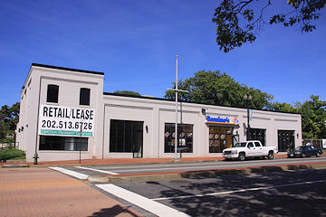
* GlobeSt.com says that the 100 M Street office building built by Opus East--and now owned by its bank after Opus went into Chapter 7 liquidation--is under contract to be sold for $80 million to Mayfield Gentry. Gentry has been pursuing the purchase since late last year. GlobeSt: "If events play out as expected, 100 M St., SE will fit nicely into the story line emerging for the District's real estate community: namely, that buildings in the city limits are still holding their value and attracting investor interest--so much so that the growing levels of distressed real estate are not likely to impact the District to any great degree."
And two quick links that I Tweeted on Friday but forgot to post here (oops):
* Want to rent out the ballpark or a portion thereof for a shindig? The NationalsEvents.com web site is now launched, with details on packages, rates, and more. (I needed this when I was trying to put together my high school reunion last year.)
* WBJ's Breaking Ground blog posted on the status of Monument's Half Street project, talking about "the hole" ("'The hole. Yes, the hole,' sighed Russell Hines") and the 55 M office building completed earlier this year which "is still empty but has experienced 'a distinct change in the level of activity' over the past two months, with a few seriously interested tenants." They're looking for ways to find financing to start construction on the residential and hotel portion on the south end of the block, but aren't finding any outlets yet; but because the site is owned outright between the equity partners (Monument, the shell of Lehman Brothers, and MacFarlane Partners), "no construction lender or mortgage holder is going to demand the keys" to the site.
|
Comments (0)
|
The Capitol Riverfront BID has decided that everyone liked the summer outdoor movie series so much, they're launching a four-week fall outdoor movie series, held this time at Second and M, on the future Canal Park site. The lineup is: Star Wars on Sept. 10, Toy Story on Sept. 17, Spaceballs on Sept. 24, and Apollo 13 on Oct. 1. (And the press release on the movie series says that construction on Canal Park will begin in Spring 2010, which is pretty much the same start date that's been on tap for awhile now.)
|
Comments (0)
More posts:
Capitol Riverfront BID, Canal Park
|
The final agenda is now out for Thursday's meeting of the National Capital Planning Commission, and contained in it is a long document setting out the commission staff's recommendations for a vote on the design of the 11th Street Bridges.
For anyone interested in the bridges as a driver, bicyclist, pedestrian, water recreationist, neighbor, or construction enthusiast, it's a worthwhile read (even at 26 pages). To cut to the chase, the staff is recommending that the commission "comment favorably" on the designs for the bridges, even though the designs are still in the very early stages, and there's very little new in this document that we didn't see in the EIS or other releases. There's even mention of how the city's Comprehensive Plan envisions the eventual dismantling of the Southeast-Southwest Freeway, but that the new bridges are needed until the time comes that I-395 comes down (i.e., far past the date I shuffle off this mortal coil).
However, they are not at all happy with DDOT's decision to choose a streetcar system with overhead wires, and the document goes into detail on how this works against federal interests, as well as listing what non-overhead-wire streetcar options exist out there (none in the US so far). Their conclusions (page 22):
"Recommends that DDOT not include streetcar system components for overhead wires as part of the 11th Street Bridge project and that DDOT prepare an environmental impact statement for its proposed District wide streetcar system that examines potential impacts on the L'Enfant City and Georgetown and that includes an analysis of propulsion systems that do not require the use of overhead wires.
"Advises DDOT that the Commission does not support a streetcar system with overhead wires because it supports the unobstructed views to important landmarks along the city's streets and avenues that are integral to the District's unique character and result from the long-standing federal statutory prohibition against using overhead wires in Washington City (the L'Enfant City) and Georgetown.
"Encourages DDOT to pursue alternative propulsion technologies for the proposed streetcar system that do not require overhead wires in accordance with its January 24, 2008 commitment to include dual vehicle propulsion requirements in a solicitation package for the development and implementation of the broader streetcar system beyond the Anacostia and H Street/Benning Road corridors."
The commission meeting when this recommendation will be voted on is Thursday (Sept. 3) at 12:30 pm.
|
Comments (0)
|
A few people wrote in over the weekend about this, including one with actual video--apparently a beep of some sort has been emanating from the DPW/Trash Transfer building at New Jersey and K (or somewhere else close by) for at least a week now. I've passed the word to Tommy Wells's office (though I imagine I'm not the first).
|
Comments (0)
More posts:
Trash Transfer Site/DPW
|
From WTOP: "Nationals fans will have a new way to get to the ballpark starting next month! That's when a water taxi will begin taking fans from the Alexandria waterfront to a dock right next to the the ballpark. It's about a 40 minute trip.
"The Potomac Riverboat Company will begin offering tickets for sale starting at noon today. 'I think it's a great price, $12 one way and $20 round trip. That includes tax,' company Vice President Charlotte Hall tells WTOP.
"Fans who live in Maryland can park at National Harbor, and take a separate water taxi across the river to catch the "baseball boat" in Alexandria. Those who want to do that will have to purchase a separate ticket for $8 one way or $16 round trip.
"Company vice president Charlotte Hall says they're offering water taxi rides to and from seven Nationals home games in September, beginning with a game against Philadelphia on Tuesday, September 8. You can also buy water taxi tickets to home games on September 9, 10, 25, 28, 29, and 30. Hall says they hope to expand service in time for next baseball season."
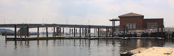
The dock is at Diamond Teague Park--if you missed my photos yesterday of the park and piers, here they are.
UPDATE: Potomac Riverboat's online ticketing ordering now has ballpark trips as an option.
|
Comments (0)
|
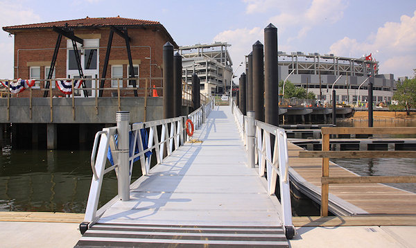
Thanks to the folks from the Gangplank, I was able to get a quick tour today of the piers and boardwalks at Diamond Teague Park, the new city-built spot on the Anacostia where water taxis and other vessels are now able to dock to bring folks to and from Nationals Park. Although construction and planting isn't quite finished, I think the batch of photos I took give a pretty good idea of the lay of the land. (I'll add them into my Teague page when I've got some more time.)
|
Comments (0)
More posts:
Teague Park
|
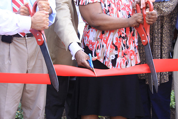
More than five years after the first demolitions at the old Capper/Carrollsburg public housing complex, city officials, developers, and residents gathered at Fourth and L today for a ribbon cutting at what is now known as Capitol Quarter, the mixed-income townhouse development that's been under construction since last year. (Residents actually started moving in this spring, but let's not spoil the party.) 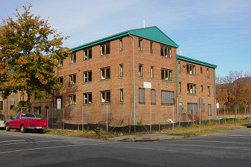
As most readers know by now, the old 707-unit Capper complex is being replaced with what will eventually include 1,500 residential units (with a one-to-one replacement of all 700 public housing units), 700,000 square feet of office space, and 50,000 square feet of retail. Two apartment buildings with 300 units for low-income seniors and moderate income residents--Capper Seniors #1 and 400 M--opened in late 2006 and 2007; four more mixed-income buildings will eventually be built on lots by Canal Park.
My photos of the festivities are posted--and enjoy them, because there aren't many ribbon cuttings in Near Southeast's near future!
I also finally updated my photos along Fifth Street this morning, and at Fourth and I and Fourth and K yesterday and today, making for a pretty striking batch of before-and-afters, especially since these are the first photos I've taken since the framing really took off on the north side of K. Also, digging is now getting started on the final block of phase 1 (Square 797, between Third, Fourth, Virginia, and I), and framing should begin in October or November, with those final first phase homes expected to be finished next spring. When will phase 2 start sales and pre-construction? As soon as they get some money, and everyone knows how easy that is right now....
I will be adding some new mid-block photos to my Capitol Quarter Phase I page, and freshening it up a bit, later today.
|
Comments (0)
More posts:
Capper, Capitol Quarter
|
2212 Posts:
Go to Page: 1 | ... 26 | 27 | 28 | 29 | 30 | 31 | 32 | 33 | 34 ... 222
Search JDLand Blog Posts by Date or Category
Go to Page: 1 | ... 26 | 27 | 28 | 29 | 30 | 31 | 32 | 33 | 34 ... 222
Search JDLand Blog Posts by Date or Category