
|
| |||||||||||||||||||

|
Please note that JDLand is no longer being updated.
peek >>
Near Southeast DC Past News Items: Southeast Blvd.
|
See JDLand's Southeast Blvd. Project Page
for Photos, History, and Details |
- Full Neighborhood Development MapThere's a lot more than just the projects listed here. See the complete map of completed, underway, and proposed projects all across the neighborhood.
- What's New This YearA quick look at what's arrived or been announced since the end of the 2018 baseball season.
- Food Options, Now and Coming SoonThere's now plenty of food options in the neighborhood. Click to see what's here, and what's coming.
![-]()
- Anacostia RiverwalkA bridge between Teague and Yards Parks is part of the planned 20-mile Anacostia Riverwalk multi-use trail along the east and west banks of the Anacostia River.
![-]()
- Virginia Ave. Tunnel ExpansionConstruction underway in 2015 to expand the 106-year-old tunnel to allow for a second track and double-height cars. Expected completion 2018.
![-]()
- Rail and Bus Times
Get real time data for the Navy Yard subway, Circulator, Bikeshare, and bus lines, plus additional transit information. - Rail and Bus Times
Get real time data for the Navy Yard subway, Circulator, Bikeshare, and bus lines, plus additional transit information. - Canal ParkThree-block park on the site of the old Washington Canal. Construction begun in spring 2011, opened Nov. 16, 2012.
![-]()
- Nationals Park21-acre site, 41,000-seat ballpark, construction begun May 2006, Opening Day March 30, 2008.
![-]()
- Washington Navy YardHeadquarters of the Naval District Washington, established in 1799.
![-]()
- Yards Park5.5-acre park on the banks of the Anacostia. First phase completed September 2010.
![-]()
- Van Ness Elementary SchoolDC Public School, closed in 2006, but reopening in stages beginning in 2015.
![-]()
- Agora/Whole Foods336-unit apartment building at 800 New Jersey Ave., SE. Construction begun June 2014, move-ins underway early 2018. Whole Foods expected to open in late 2018.
![-]()
- New Douglass BridgeConstruction underway in early 2018 on the replacement for the current South Capitol Street Bridge. Completion expected in 2021.
![-]()
- 1221 Van290-unit residential building with 26,000 sf retail. Underway late 2015, completed early 2018.

- NAB HQ/AvidianNew headquarters for National Association of Broadcasters, along with a 163-unit condo building. Construction underway early 2017.

- Yards/Parcel O Residential ProjectsThe Bower, a 138-unit condo building by PN Hoffman, and The Guild, a 190-unit rental building by Forest City on the southeast corner of 4th and Tingey. Underway fall 2016, delivery 2018.

- New DC Water HQA wrap-around six-story addition to the existing O Street Pumping Station. Construction underway in 2016, with completion in 2018.

- The Harlow/Square 769N AptsMixed-income rental building with 176 units, including 36 public housing units. Underway early 2017, delivery 2019.

- West Half Residential420-unit project with 65,000 sf retail. Construction underway spring 2017.
![-]()
- Novel South Capitol/2 I St.530ish-unit apartment building in two phases, on old McDonald's site. Construction underway early 2017, completed summer 2019.
![Novel South Capitol]()
- 1250 Half/Envy310 rental units at 1250, 123 condos at Envy, 60,000 square feet of retail. Underway spring 2017.
![-]()
- Parc Riverside Phase II314ish-unit residential building at 1010 Half St., SE, by Toll Bros. Construction underway summer 2017.
![-]()
- 99 M StreetA 224,000-square-foot office building by Skanska for the corner of 1st and M. Underway fall 2015, substantially complete summer 2018. Circa and an unnamed sibling restaurant announced tenants.
![-]()
- The Garrett375-unit rental building at 2nd and I with 13,000 sq ft retail. Construction underway late fall 2017.
![-]()
- Yards/The Estate Apts. and Thompson Hotel270-unit rental building and 227-room Thompson Hotel, with 20,000 sq ft retail total. Construction underway fall 2017.
![-]()
- Meridian on First275-unit residential building, by Paradigm. Construction underway early 2018.
![-]()
- The Maren/71 Potomac264-unit residential building with 12,500 sq ft retail, underway spring 2018. Phase 2 of RiverFront on the Anacostia development.
![-]()
- DC Crossing/Square 696Block bought in 2016 by Tishman Speyer, with plans for 800 apartment units and 44,000 square feet of retail in two phases. Digging underway April 2018.
![DC Crossing]()
- One Hill South Phase 2300ish-unit unnamed sibling building at South Capitol and I. Work underway summer 2018.
![One Hill South Phase 2]()
- New DDOT HQ/250 MNew headquarters for the District Department of Transportation. Underway early 2019.
![New DDOT HQ]()
- 37 L Street Condos11-story, 74-unit condo building west of Half St. Underway early 2019.
![37 L Condos]()
- CSX East Residential/Hotel225ish-unit AC Marriott and two residential buildings planned. Digging underway late summer 2019.
![CSX East Residential/Hotel]()
- 1000 South Capitol Residential224-unit apartment building by Lerner. Underway fall 2019.
![1000 South Capitol Residential]()
- Capper Seniors 2.0Reconstruction of the 160-unit building for low-income seniors that was destroyed by fire in 2018.
![1000 South Capitol Residential]()
- Chemonics HQNew 285,000-sq-ft office building with 14,000 sq ft of retail. Expected delivery 2021.
![1000 South Capitol Residential]()


 If you are interested in participating in the Environmental Assessment process for the redesign of Southeast Blvd., the second public meeting is scheduled for Monday night, Dec. 11, from 6:30 pm to 8:30 pm at Chamberlain Elementary School, 1345 Potomac Ave., SE.
This time around the session will be an "interactive group activity," and will also include unveiling the draft concepts for remaking the stretch of road between 11th Street SE and Barney Circle into an "urban boulvard," which would include raising the street up to the same level as L Street SE to the north, establishing connections to 13th, 14th, and 15th Streets, SE, adding pedestrian and bicycling facilities, and sneaking in some tour bus parking underneath the raised road as well. The possibility of some of the right-of-way being used for residential or other development is also part of the study.
See the official project web site for more details, or scroll through my many posts on it over the years.
|
Comments (0)
More posts:
Southeast Blvd., Traffic Issues
|
 * AMAZON HQ2: Jonathan O'Connell reports on the announcement yesterday that DC has included Southeast DC in the four sites it plans to pitch to Amazon* in the company's quest for a location for its "HQ2," a second headquarters that will need up to 8 million (!) square feet of space. It would require the cobbling together of multiple parcels in Near Southeast, Buzzard Point, and Poplar Point, almost none of which are currently controlled by the DC government. Amazon is expected to make a decision amongst the many cities putting themselves in contention in 2018. For more information on the #ObviouslyDC pitch, go to AlexaWhyDC.com. (And yes, the movie theater site is among the highlighted parcels. But remember, this is the city highlighting which parcels are still available, not what might necessarily come to pass.)
* BOWER SALES: Readers report receiving e-mails from PN Hoffman saying that the sales center for The Bower is expected to open on Sunday, Oct. 29, with some "preview appointments" available for scheduling in the time span between now and then. This is the 138-unit condo project that has been under construction for what seems like forever on the southeast corner of 4th and Tingey at the Yards. The official web site now has floor plans available (which I think I already mentioned, but whatevs).
* CAVA PROGRESS: In response to a Twitter query last week, Cava Grill says that "they are working hard" to get their new location on M Street between Half and Cushing ready to go. "Stay tuned for updates."
* RASA PROGRESS: Eater DC reports on the progress at Rasa Indian Grill, on 1st Street SE between M and N, which the owners "hope" to open in November.
* CHLOE PROGRESS: The restaurant coming to the ground floor of Arris is having a hiring open house on Oct. 26 and 27.
* SE BLVD: No pressure, but today is the last day to make comments on the environmental assessment for Southeast Blvd.
* CONSTRUCTION UPDATES: The JDLand camera has been lazy of late. But, given the weather forecast, I expect that to be rectified this weekend.
* Full disclosure: I work for the Washington Post, now owned by Jeff Bezos, Amazon's grand poobah. But Amazon does not own the Post, it must always be emphasized.
|
Comments (26)
|
 After a four-year hiatus to complete some additional studies, the Environmental Assessment to improve the desolate stretch of road between 11th Street SE and Barney Circle known as Southeast Blvd. is now back underway, with a public meeting scheduled for Saturday, Sept. 16, at Chamberlain Elementary School at 1345 Potomac Ave., SE, with an open house beginning at 10 am and presentations starting at 10:30.
 Officially, this EA "will evaluate conversion of the existing facility into an urban boulevard consistent with the expected multimodal travel demand and the character of the adjacent neighborhood." On the spiffy new web site for the EA, project elements listed include:
* Reconfiguring Southeast Blvd. upwards to match the elevation of L Street SE;
* Adding sidewalks, bicycle facilities, trees, parking, and "green infrastructure";
* Taking the "surplus transportation right-of-way" and converting it to other uses, such as parks;
* Extending 13th, 14th, and 15th Streets SE so that they connect to Southeast Blvd.;
* Adding pedestrian and bicycle links to the Anacostia waterfront (which includes getting across the train tracks that run along the boulevard's southern side);
* Reconfiguring Barney Circle; and
* Building an "under-deck bus transit support facility with bus access via 11th Street SE and/or Barney Circle." (I bet they say this one really quickly and quietly.)
I cannot bear to rehash many years' worth of meetings and designs here, but I would point interested readers to my post from early 2016 about the DDOT Southeast Blvd. Feasibility Study. If I may plagiarize myself: "And what does the feasibility study say? DDOT's report determines that changing the current Southeast Blvd. from the limited-access quick route between 11th Street SE and Barney Circle to a street with connections to its north and south and development along the footprint is feasible, but the transformation 'would be neither inexpensive nor quick'."
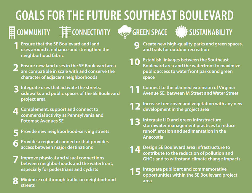
I also wrote about the Office of Planning's Southeast Blvd. Planning Study, which had as its purpose "not to identify a single 'preferred alternative,' but rather to develop concepts that respond to the planning goals and objectives for the District and the community, which could be advanced through further study." Those concepts looked like this:
And so now we continue onto the Environmental Assessment. See my SE Blvd page for more history (including the demolition of the old freeway and DDOT's quickie reinstallation of a new road), or just scroll down through my previous posts on it, if you dare.
|
Comments (50)
More posts:
Southeast Blvd., Traffic Issues
|
Last week DDOT released its Southeast Blvd. Feasibility Study, in which the agency "evaluated the feasibility of transitioning a segment of the former Southeast Freeway from 11th Street to Barney Circle into an urban boulevard more consistent with the expected travel demand and the character of the adjacent neighborhood." This study was a follow-on to the Office of Planning's Southeast Blvd. Planning Study, which came about after residents expressed displeasure with the initial efforts seen in the Barney Circle-Southeast Blvd. Transportation Planning Study.
And what does the feasibility study say? DDOT's report determines that changing the current Southeast Blvd. from the limited-access quick route between 11th Street SE and Barney Circle to a street with connections to its north and south and development along the footprint is feasible, but the transformation "would be neither inexpensive nor quick."
The study then goes through the issues that make clear this would not be a snap-the-fingers-and-make-it-so proposition:
*Ownership: There are two small parcels within the study area owned by the National Park Service--and we know quickly either arranging for a change in ownership or "coordinating" with NPS can go. The study refers to it as being clear "that there would be significant process requirements and challenges to disposing the NPS and incorporating them into private development." That the process to "surplus" any excess land along the footprint not needed for the road(s) itself is governed by the Federal Highway Administration would also not point to a lightning-quick resolution.
* Transit Garages: The inclusion of some location that would allow for the parking of tour buses, transit buses and streetcars {cough}--a big part of DDOT's wishes for the area but something that residents are not particularly keen on--"could be provided at Southeast Boulevard that takes advantage of the location and topography of the site to minimize visual impacts to surrounding neighborhoods and so that vehicles accessing the facility would not use residential neighborhood streets."
* Cost: The study's "cursory assessment" says that constructing the transportation elements of the project would cost around $120 million, with a transit garage adding about $65-70 million in costs (in 2015 dollars). This includes reconfiguring Barney Circle into an at-grade signalized traffic circle, raising Southeast Boulevard to the same level as L Street, and constructing a four-lane street that includes sidewalks, bike facilities, and traffic signals. Plus some contingency costs built in.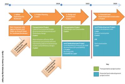
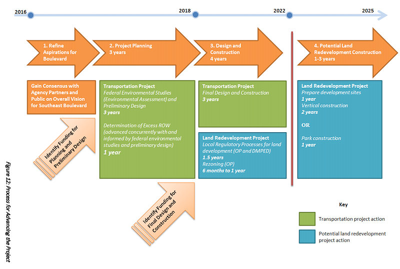
* Schedule: The graphic at right breaks out a not-short ballpark timeline of 10 years for both the "transportation" portion of the project and the land redevelopment project.
With all of that, DDOT says that the first step forward is to restart the Barney Circle and Southeast Blvd. Transportation Planning Study begun in 2013, though even that now has a road block, that this Environmental Assessment now can't be completed "until a financial plan for project implementation is identified and included in the regional Constrained Long-Range Transportation Plan (CLRP)." DDOT advises interested groups "to continue discussions with a broad spectrum of stakeholders during the EA to confirm community support for the project, engage with AWI Signatories, and evaluate project costs and funding options."
This final draft was presented to ANC 6B's Transportation Committee on Jan. 6, and Capitol Hill Corner reports that DDOT's representative told the committee that there were no "fatal flaws" in any of the Office of Planning's three concepts for reimagining the road--but that it will be "up to ANC 6B to push the project forward" by requesting the environmental assessment.
I am skimming it all, so if this project is of interest to you, be sure to read the feasibility report, and perhaps attend ANC 6B's meeting on Jan. 12, at which a draft letter will apparently be considered to support going ahead with the EA.
You can also wander through my posts on the subject from the past few years, especially on the completion of the OP study back in July and the three general concepts advanced for how to remake this stretch of land that currently serves as such a barrier between Capitol Hill/Hill East and the Anacostia River.
|
Comments (7)
More posts:
Southeast Blvd., Traffic Issues
|
 The Office of Planning has posted the final version of its Southeast Blvd. planning study that was undertaken in early 2014 after Tommy Wells and ANC 6B found DDOT's initial designs for reconfiguring the stretch of road between 11th Street and Barney Circle decidedly lacking.
 I wrote about OP's concepts after its public meeting back in December, and the designs in this final report are the same, still including elevating the road to the height of L Street directly to the north and the extensions of 13th, 14th, and 15th streets, along with varying approaches to including residential development in the median (or not) and including (or not) the underground bus parking so close to DDOT's heart.
The report reminds readers that the "purpose of this planning study was not to identify a single 'preferred alternative,' but rather to develop concepts that respond to the planning goals and objectives for the District and the community, which could be advanced through further study."
However, it goes on to say that OP has recommended developing a "hybrid concept," "based largely on the street network and development program described in Concept A, but incorporate pocket parks or other public open space interspersed throughout the new development parcels in ways that enhance the neighborhood and support the viability of new development."
And now that this study is finished, DDOT is undertaking its own feasibility study, "to determine the project development process and the economic viability of integrating the land use concepts that emerged from the Office of Planning’s (OP) Southeast Boulevard Planning Study with the transportation alternatives."
Once THAT is done, it will be all rolled into the Barney Circle-Southeast Blvd. Transportation Planning Study that began back in 2013.
In the meantime, of course, DDOT went ahead and built the road, opening it in late 2014.
I am admittedly giving short shrift to the final OP report, so if the fate of the road is of interest to you, be sure to read the whole thing, along with my post about it from last year.
Representatives of OP and DDOT will apparently be providing an update on all the Barney Circle-Southeast Blvd. studying tonight (Wednesday, July 8) at 7 pm at the Hill Center, 921 Pennsylvania Ave., SE, as part of ANC 6B's Transportation Committee meeting.
|
Comments (0)
More posts:
Southeast Blvd., Traffic Issues
|
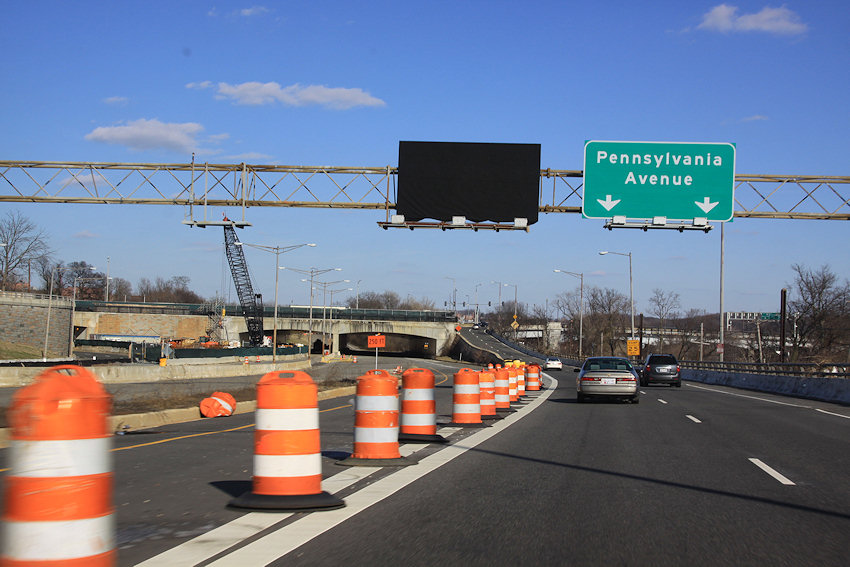
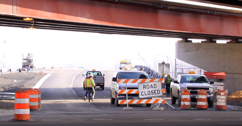
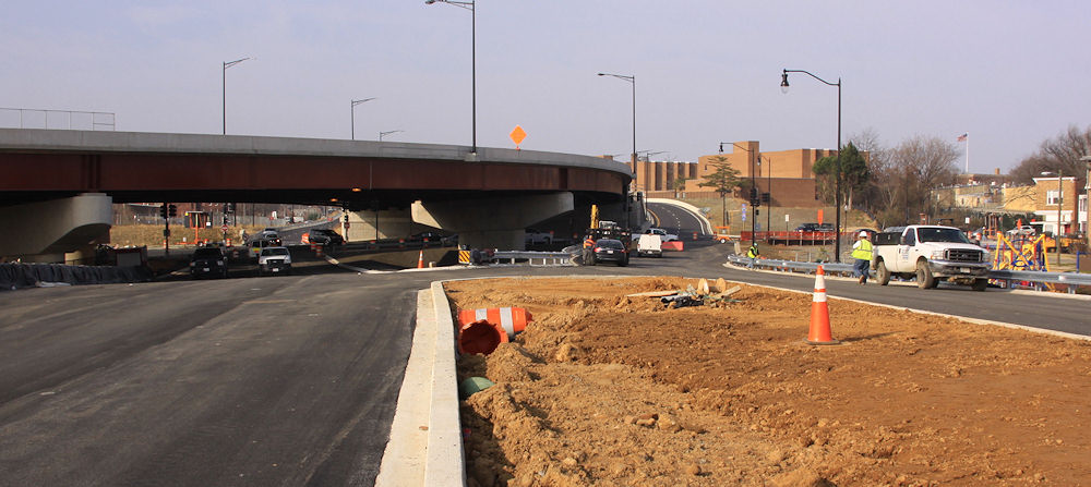
 DDOT announced that today (Dec. 22) they have opened Southeast Blvd. between 11th St. SE and Pennsylvania Avenue at Barney Circle.
Considering it looked like this nine days ago, the pedal must have been put to the metal.
Anyone want to report from there? I'll be interested to see how the signalized section at 11th Street handles the presumed new influx of east/west traffic.
The planning project to come up with concepts for how the road could look and function in the future continues.
UPDATE, 9:15 PM: Dark? Rainy? What a perfect time to try out a new road! I was coming home a little while ago on the SW/SE Freeway from Virginia, so decided to follow them there new signs for "Southeast Blvd."
I crossed 11th Street at the bottom of the exit ramp from the SE Freeway, then drove east on the new road to the light/merge at Pennsylvania Avenue just before the Sousa Bridge, where I'd still be sitting if I hadn't decided to finally run the light after waiting and waiting and waiting. (The stretch of road that continues eastward under Barney Circle is not reopened, though there is line striping for a lane to eventually head that way, it's just blocked off.)
Then, after a fun reversing of course that involved doubling back via DC-295 and two of the new ramps to and from 11th Street SE/MLK Blvd., I went westward on Pennsylvania Avenue and took the exit "To I-395." That goes under Barney Circle as it used to, and eventually I returned to 11th Street SE at the new signalized intersection where I could have chosen to go straight to get onto the westbound SE Freeway.
Impressions? Hard to tell in the rain. The MC Dean folks were out working on the signals, there's still a lot of cleanup work going on in the median, and a lot of heavy construction work is still in evidence on the eastern end by Barney Circle.
But if the city wants to rake in the dough, they'll set up speed cameras to enforce the SPEED LIMIT 30 signs that I LOL'ed at as I drove past them. Call it a "Boulevard" or call it a limited-access divided highway, but it is not a streetscape that screams 30 MPH.
(Photos will have to wait until the sun is actually out.)
UPDATE, 12/23: Via my very poorly paid stringer (Mr. JDLand), one shot of the now-uncovered signage for Southeast Blvd. eastbound on I-695/SE Freeway.
|
Comments (0)
More posts:
Southeast Blvd., Traffic Issues
|
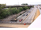
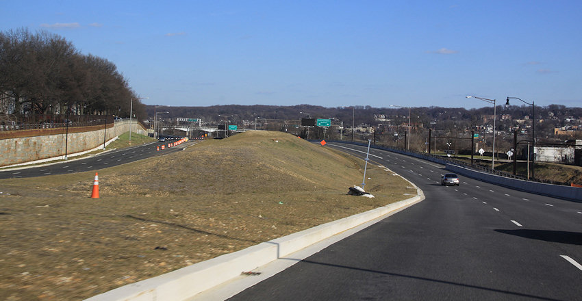
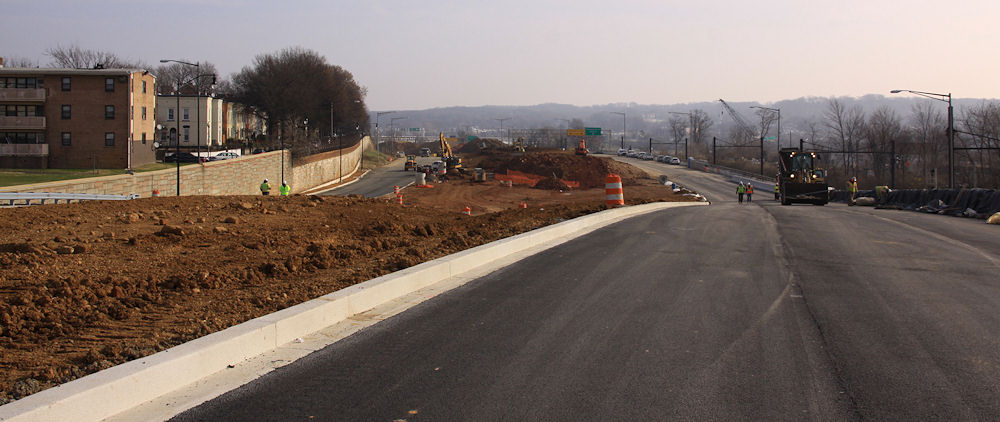
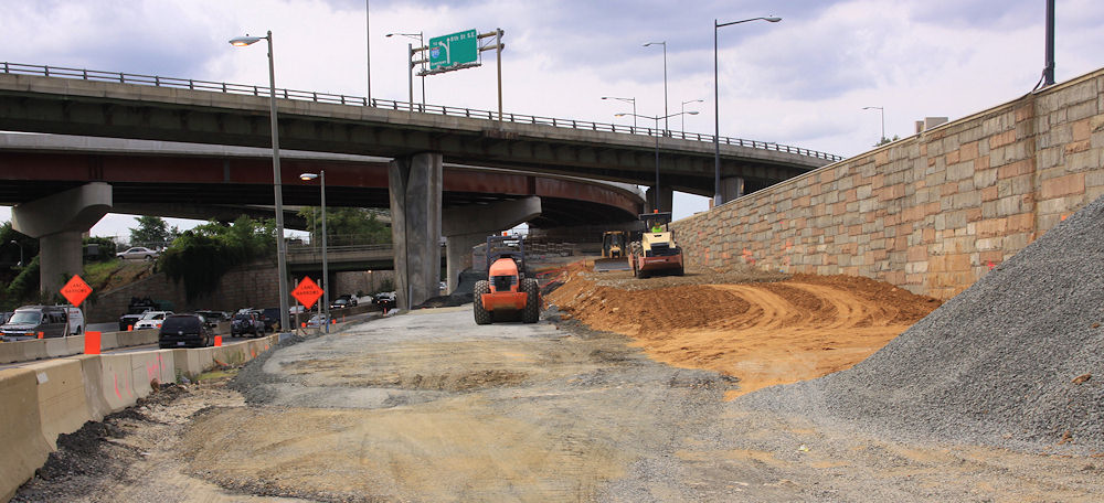
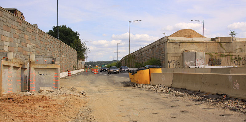
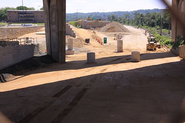
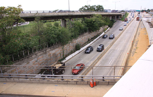
 I finally got my lazy self over to 11th Street with my camera this past weekend, and got quite the view of the soon-to-arrive Southeast Blvd., the reconstituted road between Barney Circle and 11th Street that runs along the path of the old sunken east end of the Southeast Freeway.
 A kind official, taking a wild guess at who that old lady shooting photos of construction might possibly be, guided me in for a quick peek over the crest of the hill, eastward toward Barney Circle:
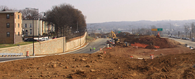
The new road will be two lanes in each direction, separated by a fair amount of non-road area, as you can see. At the new signalized intersection with 11th Street, the lanes align with the new ramps to and from the Southeast Freeway. Here's what the approach to 11th Street looked like in 2012, when the freeway still ran beneath 11th, along with the similar-but-higher-up view now. (Click to enlarge, and use the massive freeway pylons and flyover to orient yourself, especially in terms of the vertical change.)
As I have written about previously, there has been a fair amount of consternation over this road, both in terms of what some people feel is a rush to get it reopened along with much unhappiness when DDOT unveiled its initial concepts for the road's long-term design. The Office of Planning has since been working on a new set of designs to better meet a goal of reintegrating this area with the surrounding neighborhood, and last week there was a public meeting to go over these concepts, seen below and laid out in detail in the presentation slides.
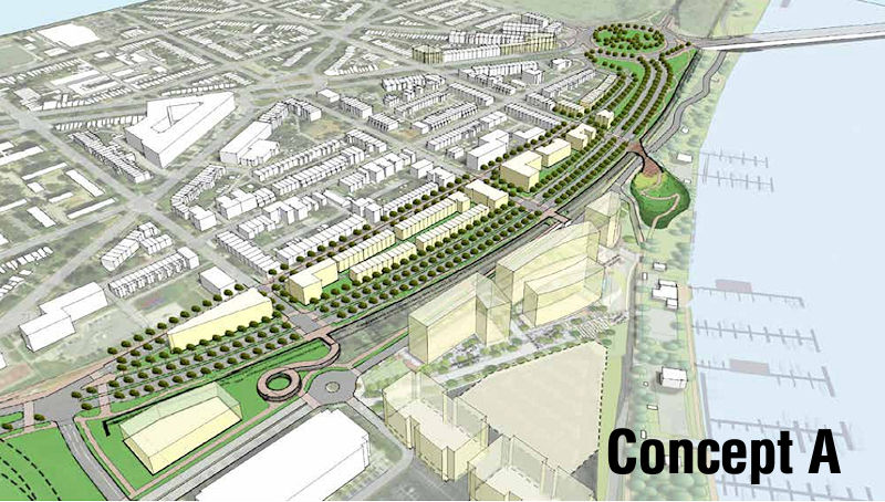
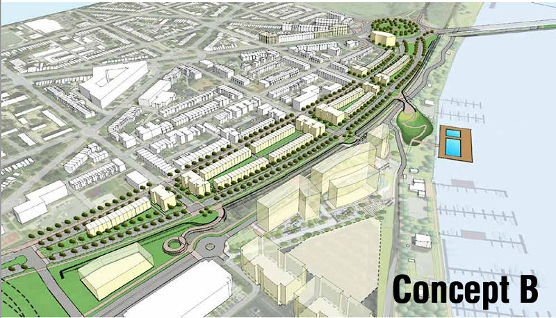
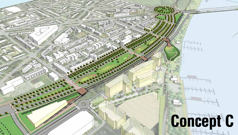
When comparing these concepts to the road about to open, you can see that the general layout of the traffic lanes and available space are the same, though Concept B has just one lane in each direction just one new two-lane boulevard heading eastward while A and C have two lanes in each direction (UPDATED to fix how B is characterized). (And bike lanes! There are bike lanes!) However, all three would build up the boulevard so that it would become level with L Street, and would then allow 13th, 14th, and 15th streets to intersect with the boulevard for both vehicular and pedestrian traffic.
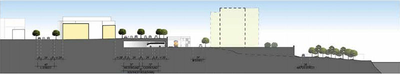 At right is a side view showing the proposed elevation for Concept A, running from L Street at left over to the train tracks and then down to the river.The CSX train tracks that run to the right of the road's footprints prevent further connection of these streets to M Street and the river, but there could be pedestrian bridges built to bring people across the tracks. (Note that all three concepts show the position of the planned 1333 M Street residential project just south of the boulevard.)
 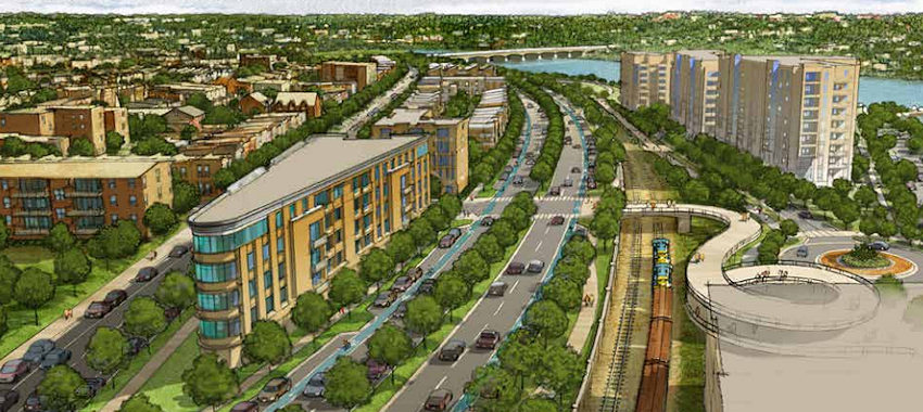 Two of the designs call for development within the huge median, either of low-rise multi-family buildings or townhouses or some combination thereof (at right is a rendering of the Concept A vision). The third design leaves it as a wide-open park space. And two of the three plans show the parking beneath the boulevard for buses that seems to be a requirement from DDOT's point of view.
I'm not going to go into great detail about what was said at the meeting--you can browse the presentation slides and read Capitol Hill Corner's report, which includes the many concerns of nearby residents, especially the ones who don't have much interest in connecting L, 13th, 14th, and 15th to this road.
At this stage, these truly are just concepts. There would next need to be a feasibility study/traffic flow analysis done by DDOT, an undertaking that has no timetable. There is also the issue of this land having been turned over to the city by the feds with the requirement that it be used for "transportation purposes," which raises questions about whether plopping residential buildings in the middle of it all would be an issue.
In the meantime, the new version of this road should open early in 2015.
Here's one more before-and-almost-after, looking eastward from down in the depths back in 2012 (left) and then an expanded version of the current view. Use the apartment building and retaining wall at left to orient. The embankment in the median in the "before" photo is the remnant of the ramps from the old 11th Street Bridges to and from RFK.
|
Comments (6)
More posts:
Southeast Blvd., Traffic Issues
|
 A community meeting is on tap for Thursday (tomorrow), Dec. 11, to discuss the future Southeast Blvd., specifically the ideas emerging from the neighborhood study currently being spearheaded by ANC 6B, the Office of Planning, and DDOT.
The meeting is from 7 to 9 pm at Friendship Chamberlain Elementary School, 1345 Potomac Ave., SE, across from the Jenkins Row Harris Teeter.
Councilmember Tommy Wells will be there, and will be part of the discussion on how to best integrate into the neighborhood this road that will run from Barney Circle to the new intersection at 11th Street, SE, along the path of the old sunken portion of the Southeast Freeway.
A "temporary" version of the road is opening in early 2015, and residents have been concerned both about this becoming the de facto new version of the road, a feeling that came on the heels of the original new designs put forth by DDOT, that were basically replacing an old freeway with a new freeway, albeit it one that has a stoplight at 11th Street rather than just a free-and-clear approach to the Southeast Freeway. After those designs were released, with a push from Wells, the Office of Planning stepped in to help shepherd a neighborhood study--initial design concepts were unveiled back in August, and this week's meeting is to continue the process of refining the possibilities.
(And I am well aware that I have completely failed at keeping up with photographs of that area of 11th and of the work underway on the temporary road. All of the construction there, and the futzing with the traffic flow configuration of 11th Street while work continues around it, have made me very cranky about going over there to take pictures. Maybe this will finally spur me.)
|
Comments (4)
More posts:
meetings, Southeast Blvd., Traffic Issues
|
 ANC 6B commissioners Brian Flahaven and Kirsten Oldenburg have both written about a new batch of design concepts for Southeast Blvd., the planned stretch of road between 11th Street SE and Barney Circle where the sunken far eastern portion of the Southeast Freeway used to run.
Almost a year ago, DDOT presented five designs for the new road that basically, as Flahaven puts it, "replaced the freeway with ... a freeway completely separated from the neighborhood grid." The designs were not well received, and with a push from councilmember Tommy Wells, the Office of Planning stepped in to conduct a "rapid response" study of the neighborhood and the project. And on Aug. 4, these new designs were unveiled at a public meeting.
The boards show both two-lane and four-lane designs for the road, some with direct access to the Anacostia Waterfront and extension of the street grid to the boulevard, some without. The Office of Planning now plans to take community feedback--which apparently was considerably more positive this time around--and move forward with three final concepts that can be presented to the community and to DDOT this fall.
However, it also turns out that DDOT is planning to go ahead and reopen this stretch of road by the end of the year, with the traffic flowing through the new signalized intersection on 11th Street SE where the exit ramp from the Southeast Freeway recently opened. Oldenburg describes what she see as the "major implications" of this move: "First, this freeway segment becomes the No Build option in the study. Second, in my view, it will take the pressure off city officials to get the NEPA study completed in a timely manner, hopefully, incorporating some of the fresh ideas generated by the OP study."
Flahaven is urging residents to contact Mayor Gray and council members with their thoughts on this.
|
Comments (11)
More posts:
Southeast Blvd., Traffic Issues
|
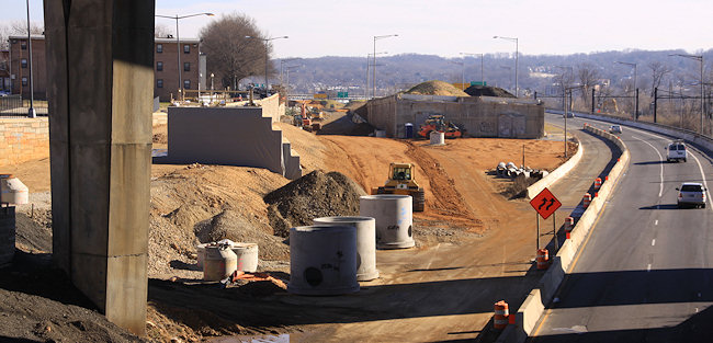
Despite it being four weeks after the fact, JDLand's strict operating requirements still dictate that I document the new exit ramp to 11th Street SE from eastbound I-695. 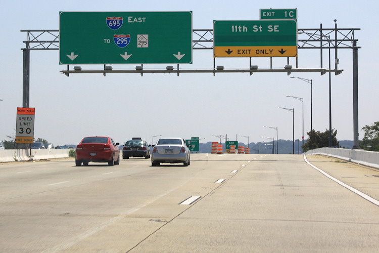 The view driving east on the Southeast Freeway (which is now I-695, if you haven't gotten the memo). If you always get off at or before the 6th Street SE exit, this may be an unfamiliar vista to you. The left lanes head toward the outbound 11th Street Bridges, while the right two lanes are the new movement that didn't exist before this whole project got underway. (And is that hidden part of the 11th Street sign maybe an eventual pointer to Southeast Blvd.?)
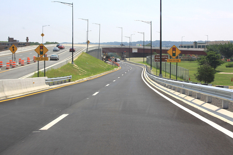 Behold, the new ramp! You also get to see the two new flyovers at left that have been built as part of this project, which has been underway since 2009. Sneaking up in between is the new on-ramp from 8th Street SE, which opened not long ago. At right is Virginia Avenue Park. Note also the sign pointing toward Anacostia Park--this would take you down 11th to the new local bridge and to the park that-a-way.
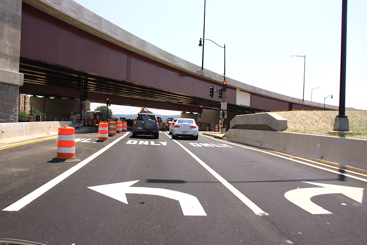 And now you come to the intersection at 11th. Turning left takes you north toward Pennsylvania Avenue and Lincoln Park, while turning right takes you to M Street, the Navy Yard, and the local bridge. Note the blocked-off third lane that is striped for left turns as well--I assume there will come a time when the middle lane will be for traffic continuing straight on Southeast Blvd.
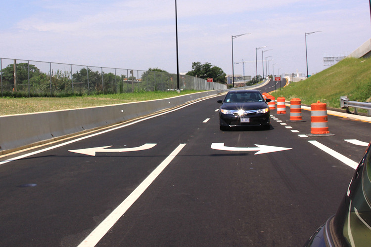 Wrapping up our little journey, here's a quick look backward at the road just traveled.
With thanks to Mr. JDLand for chauffeuring, here's what it's like to venture along this new route, if you haven't done it. (And sure, I could have Vined it, or YouTubed it, or whatever, but what fun would that be?)
The view driving east on the Southeast Freeway (which is now I-695, if you haven't gotten the memo). If you always get off at or before the 6th Street SE exit, this may be an unfamiliar vista to you. The left lanes head toward the outbound 11th Street Bridges, while the right two lanes are the new movement that didn't exist before this whole project got underway. (And is that hidden part of the 11th Street sign maybe an eventual pointer to Southeast Blvd.?)Behold, the new ramp! You also get to see the two new flyovers at left that have been built as part of this project, which has been underway since 2009. Sneaking up in between is the new on-ramp from 8th Street SE, which opened not long ago. At right is Virginia Avenue Park. Note also the sign pointing toward Anacostia Park--this would take you down 11th to the new local bridge and to the park that-a-way.And now you come to the intersection at 11th. Turning left takes you north toward Pennsylvania Avenue and Lincoln Park, while turning right takes you to M Street, the Navy Yard, and the local bridge. Note the blocked-off third lane that is striped for left turns as well--I assume there will come a time when the middle lane will be for traffic continuing straight on Southeast Blvd. Wrapping up our little journey, here's a quick look backward at the road just traveled. Need a reminder of what this spot used to look like? Remember the phrase "sunken freeway"? Here's a reminder, from street level and from above.


And, because I am a complete nutcase (which we already knew), here is a bunch of photos--strung together as a slideshow--that I took just as the 11th Street Bridges project was getting underway in early 2010, showing what it used to be like to drive across the Anacostia on that route. Apologies for the dirty windshield.
(I know, my archive just gets more and more alarming.)
|
Comments (2)
More posts:
11th Street Bridges, Southeast Blvd., Traffic Issues
|