
|
| |||||||||||||||||||

|
Please note that JDLand is no longer being updated.
peek >>
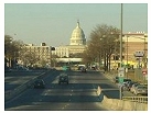
Near Southeast DC Past News Items: South Capitol St.
|
See JDLand's South Capitol St. Project Page
for Photos, History, and Details |
- Full Neighborhood Development MapThere's a lot more than just the projects listed here. See the complete map of completed, underway, and proposed projects all across the neighborhood.
- What's New This YearA quick look at what's arrived or been announced since the end of the 2018 baseball season.
- Food Options, Now and Coming SoonThere's now plenty of food options in the neighborhood. Click to see what's here, and what's coming.
![-]()
- Anacostia RiverwalkA bridge between Teague and Yards Parks is part of the planned 20-mile Anacostia Riverwalk multi-use trail along the east and west banks of the Anacostia River.
![-]()
- Virginia Ave. Tunnel ExpansionConstruction underway in 2015 to expand the 106-year-old tunnel to allow for a second track and double-height cars. Expected completion 2018.
![-]()
- Rail and Bus Times
Get real time data for the Navy Yard subway, Circulator, Bikeshare, and bus lines, plus additional transit information. - Rail and Bus Times
Get real time data for the Navy Yard subway, Circulator, Bikeshare, and bus lines, plus additional transit information. - Canal ParkThree-block park on the site of the old Washington Canal. Construction begun in spring 2011, opened Nov. 16, 2012.
![-]()
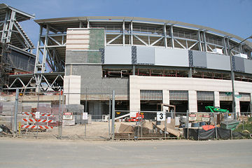
- Nationals Park21-acre site, 41,000-seat ballpark, construction begun May 2006, Opening Day March 30, 2008.
![-]()
- Washington Navy YardHeadquarters of the Naval District Washington, established in 1799.
![-]()
- Yards Park5.5-acre park on the banks of the Anacostia. First phase completed September 2010.
![-]()
- Van Ness Elementary SchoolDC Public School, closed in 2006, but reopening in stages beginning in 2015.
![-]()
- Agora/Whole Foods336-unit apartment building at 800 New Jersey Ave., SE. Construction begun June 2014, move-ins underway early 2018. Whole Foods expected to open in late 2018.
![-]()
- New Douglass BridgeConstruction underway in early 2018 on the replacement for the current South Capitol Street Bridge. Completion expected in 2021.
![-]()
- 1221 Van290-unit residential building with 26,000 sf retail. Underway late 2015, completed early 2018.

- NAB HQ/AvidianNew headquarters for National Association of Broadcasters, along with a 163-unit condo building. Construction underway early 2017.

- Yards/Parcel O Residential ProjectsThe Bower, a 138-unit condo building by PN Hoffman, and The Guild, a 190-unit rental building by Forest City on the southeast corner of 4th and Tingey. Underway fall 2016, delivery 2018.

- New DC Water HQA wrap-around six-story addition to the existing O Street Pumping Station. Construction underway in 2016, with completion in 2018.

- The Harlow/Square 769N AptsMixed-income rental building with 176 units, including 36 public housing units. Underway early 2017, delivery 2019.

- West Half Residential420-unit project with 65,000 sf retail. Construction underway spring 2017.
![-]()
- Novel South Capitol/2 I St.530ish-unit apartment building in two phases, on old McDonald's site. Construction underway early 2017, completed summer 2019.
![Novel South Capitol]()
- 1250 Half/Envy310 rental units at 1250, 123 condos at Envy, 60,000 square feet of retail. Underway spring 2017.
![-]()
- Parc Riverside Phase II314ish-unit residential building at 1010 Half St., SE, by Toll Bros. Construction underway summer 2017.
![-]()
- 99 M StreetA 224,000-square-foot office building by Skanska for the corner of 1st and M. Underway fall 2015, substantially complete summer 2018. Circa and an unnamed sibling restaurant announced tenants.
![-]()
- The Garrett375-unit rental building at 2nd and I with 13,000 sq ft retail. Construction underway late fall 2017.
![-]()
- Yards/The Estate Apts. and Thompson Hotel270-unit rental building and 227-room Thompson Hotel, with 20,000 sq ft retail total. Construction underway fall 2017.
![-]()
- Meridian on First275-unit residential building, by Paradigm. Construction underway early 2018.
![-]()
- The Maren/71 Potomac264-unit residential building with 12,500 sq ft retail, underway spring 2018. Phase 2 of RiverFront on the Anacostia development.
![-]()
- DC Crossing/Square 696Block bought in 2016 by Tishman Speyer, with plans for 800 apartment units and 44,000 square feet of retail in two phases. Digging underway April 2018.
![DC Crossing]()
- One Hill South Phase 2300ish-unit unnamed sibling building at South Capitol and I. Work underway summer 2018.
![One Hill South Phase 2]()
- New DDOT HQ/250 MNew headquarters for the District Department of Transportation. Underway early 2019.
![New DDOT HQ]()
- 37 L Street Condos11-story, 74-unit condo building west of Half St. Underway early 2019.
![37 L Condos]()
- CSX East Residential/Hotel225ish-unit AC Marriott and two residential buildings planned. Digging underway late summer 2019.
![CSX East Residential/Hotel]()
- 1000 South Capitol Residential224-unit apartment building by Lerner. Underway fall 2019.
![1000 South Capitol Residential]()
- Capper Seniors 2.0Reconstruction of the 160-unit building for low-income seniors that was destroyed by fire in 2018.
![1000 South Capitol Residential]()
- Chemonics HQNew 285,000-sq-ft office building with 14,000 sq ft of retail. Expected delivery 2021.
![1000 South Capitol Residential]()


246 Blog Posts Since 2003
Go to Page: 1 | ... 11 | 12 | 13 | 14 | 15 | 16 | 17 | 18 | 19 ... 25
Search JDLand Blog Posts by Date or Category
Go to Page: 1 | ... 11 | 12 | 13 | 14 | 15 | 16 | 17 | 18 | 19 ... 25
Search JDLand Blog Posts by Date or Category
Today is the day that the northernmost 200 feet of the Douglass Bridge (north of the Anacostia shoreline) is being lowered by as much as four feet so that the bridge's approach can begin/end at Potomac Ave. I've got some photos of the initial work this morning, but the photos aren't exactly action-packed, thanks to the lowering pace of two inches per hour. You can see the jacks in place and all the hubbub of work going on, as well as the new earth-fill ramp leading up to the bridge (which was a surprise for me, I didn't realize how far along the ramp already is).
I'm going to head back down this afternoon, when the light is better, and take some shots of the progress, so check back later in the day; I'll also be adding links to the media coverage as they pop up.
The lowering is scheduled to be completed late tomorrow morning.
UPDATE: Here's WTOP's piece.
UPDATE II: I went and got some seven-hours-later shots, which you can see side-by-side with the morning shots. It's of course nowhere near as dramatic as the befores-and-afters of the bridge's demolition last week, but you can tell a difference.
|
More posts:
Douglass Bridge, Traffic Issues
|
The next big "moment" in the Douglass Bridge's Extreme Makeover is scheduled for tomorrow (Thursday, June 19), and that's the lowering of the elevated northern approach of the bridge by just over four feet. According to today's media advisory from DDOT, this will happen veeeeeery slowly--"coming down by approximately two inches per hour"--and is expected to take 24 hours from start to finish. Starting at 8 am, crews will "cut" the bridge's support columns, and then the bridge deck will be supported and lowered by more than 35 hydraulic jacks, with four jacks at each support pier. If you want to get a feel for exactly what's going to happen, DDOT's video on the Douglass Bridge changes has an animation of the lowering at about the 4:20 mark.
Look for TV coverage of it all tomorrow; and I wouldn't be surprised if a certain blogger posts some visuals of it, too.
|
More posts:
Douglass Bridge, Traffic Issues
|
From a DDOT press release entitled "Frederick Douglass Memorial Bridge Renovation on Schedule" (now online), a list of what's to come this week now that the demolishing is done: "Forming of new light poles, continuing the bridge deck repairs and the completion of the deck testing, utility work on South Capitol Street, setting of jack towers, [and] the lowering of the bridge of Thursday, July 19." Since it might be three or four whole days before I venture back down there for new pictures, you'll have to settle in the meantime for last week's shots and the Stadium Construction Webcam Camera #2.
|
More posts:
Douglass Bridge, Traffic Issues
|
With the area in the stadium corridor between South Capitol and First streets apparently in need of significant upgrades to its water and sewer infrastructure, the city council is working on a bill that would create a special assessment to fund the $15.45 million needed for the improvements. It was decided to take care of these upgrades now because the streets that the pipes lie under--South Capitol, Potomac, First, N, and I--are scheduled to be reconstructed in the coming months as part of the streetscape improvement project before the Nationals ballpark opens, and it was thought best to take care of the sewer work now rather than having to dig up newly renovated streets. Landowners (including the city and the U.S. government) would be assessed based on total land area and the gross building area as allowed by zoning for each parcel of land that abuts or benefits from the improvements, and would be able to pay their assessment either in an up-front lump sum or over time. With the city contributing $3 million toward the project up front and another $4.1 million to cover the assessments on public properties, the other landowners will end up funding $8.35 million of the project cost.
The bill was marked up on July 13, and apparently has changed somewhat, but you can read the original version of the legislation here. When the committee report is finalized and the revised bill is available, I'll post them as well.
It should be noted that the water and sewer improvements for the stadium itself have already been taken care of, and similar improvements for The Yards and Capper/Carrollsburg will be handled through their PILOT funding programs.
|
|
Steve Eldridge, in his traffic column in the Examiner today, reports he has heard very few complaints from readers related to the Douglass Bridge closure and its spillover effects. "It seems like the city did a very good job at planning ahead for this event including the decision to do the work during the summer months, when traffic volumes are at their lows for the year. [...] I know that we give the District a hard time in this space, but this project seems to be something that has been well thought out and well executed ... at least so far." Dr. Gridlock in the Post wrote a lot about it in his Get There blog early last week, but hasn't covered it for a few days.
|
More posts:
Douglass Bridge, Traffic Issues
|
 I hit the pavement this morning (before it began to melt a few hours later), and have posted a pile of new photos in the Stadium Exterior Construction Gallery, the additional north/south/east/west stadium views for the fanatics, and the Douglass Bridge Extreme Makeover page, which in particular has more new stunning before-and-afters of the South Capitol Street/Potomac Avenue intersection.
|
More posts:
Douglass Bridge, Nationals Park
|
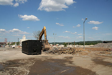 On this gorgeous late afternoon (which would have been PERFECT for a Topping Out ceremony!), I got back down to the Douglass Bridge demolition for the first time in a few days, and whether it was the deep blue sky or the new camera lens or what, I snagged some pretty striking photos of the changed landscape on South Capitol Street between N and Potomac. I've posted them on my Douglass Bridge Extreme Makeover page, of course--I also added some more stitched-together panoramas of what the intersections looked like before. All the new shots today are from the west side--access to the east side of South Capitol is far more limited thanks to the stadium, so shots looking westward from anywhere other than Potomac Ave. may just have to wait until the work is all done. I'm going to be working on getting more photos of these intersections into the Photo Archive; but I've been just a wee bit busy over these past few days (!) and so haven't had the chance.
Speaking of the work, there was nothing left of the old viaduct on my visit other than the pile of dirt that used to make up the earth-fill ramp between O and P streets (well, there's whole lot of rubble, too). So we can say that the demolition took six days. Now we get to watch for the lowering of the northernmost remaining portion of the bridge, the building of the new earth-fill ramp up from Potomac Ave. to meet the existing bridge, and the streetscaping of the rest of South Capitol. And we get to see just how quickly the contractor can pull this off ahead of the eight-week schedule. (Up to $1 million in incentives are being dangled in front of them.)
Getting it done quick will certainly ease the burden of thousands of commuters, who are really taking it on the chin with this project. Today there's a number of stories about Metro ticketing the folks who are parking illegally in the lots on the east side of the Anacostia. Channel 9, Channel 7, Channel 4, WTOP, and the Post's Marc Fisher all weigh in. And the Southern Maryland Gazette writes about the traffic problems from an outside-the-Beltway perspective.
|
More posts:
South Capitol St.
|
The demolition of the beams from the old Douglass Bridge viaduct along South Capitol Street north of Potomac continues apace today, and you can really "watch" it over the next few hours on Camera #2 of the Stadium Construction Webcam, which updates every 20 minutes or so. Just keep hitting the "View Most Recent Image" box under the calendar (and zoom in for a better view). I'm betting they'll be finished with the beams by the end of the day or tomorrow, and will have only the earth fill approach ramp north of P left. Then there'll be the cleanup and the work to create the new roadway over the next few weeks, but that won't be anywhere near as much fun to check out on the webcam as the demolition is..... (Plenty of other work will be happening out of the webcam's view, of course, such as the lowering of the portion of the bridge just north of the Anacostia shoreline and the building of the new ramp down to Potomac Ave.) And note that the concrete pillars you see in the ground in front of the bridge demolition are for the "knife-edge" Nationals office building that will be attached to the stadium. You can see the concrete already starting to be poured for the south point of the building. And the line of steel beams in front of the admin building construction are for the sloped promenade that will come from Potomac Avenue up to the stadium.
We do need to offer them a hankie to clean the lens, though!
UPDATE. 5:15 pm: The girders are now all gone--all that's left of the viaduct is the brick-lined ramp between O and P, and it won't last much longer, either. As fun as it is to sneak peeks of it on the webcam, I had hoped to have new photos of my own today--but the deluge during the stadium topping out dampened my enthusiasm for further picture taking. More pics soon, I promise.
|
More posts:
South Capitol St., Douglass Bridge, Traffic Issues
|
Removal of the steel girders along the old northern approach of the Douglass Bridge viaduct continues today, and that work has now come into view when looking at Camera #2 of the Nationals Stadium Construction Cam, starting with the 12:32 pm image. (And, for the fun of it, check out the 2:27 and 2:41 images for the Noah's Ark view of the site.) Dr. Gridlock's blog has another entry today about the traffic fallout from the bridge's closure. And of course my Douglass Bridge Extreme Makeover page has my photos of the site, with more to come tomorrow. UPDATE: Another Dr. Gridlock post discusses the now-overflowing state of the Anacostia Metro station parking lot.
|
More posts:
South Capitol St., Douglass Bridge, Traffic Issues
|
Once again venturing reluctantly into the world of live human beings, I went to last night's Zoning Commission meeting. Here's a wrapup:
* After waiting a month to get input from the Office of Planning, the ZC gave some guidance on Florida Rock's revised plans for its 5.8-acre site on the Anacostia. The phrase uttered most often was "on the right track" -- each commissioner mentioned something in the new designs that they weren't completely crazy about (the glass "campanile" viewing tower on the east building seemed not to have wowed them), but they were mainly complimentary, making clear that the new design was an improvement over the last go-round and is closer to what the ZC wants to see on the site. (Read my entry from February for more background on the ZC's objections to the last design.)
This was not any sort of decision-making stage--the Florida Rock developers were wanting to make sure that they didn't expend vast amounts of energy pursuing a design that would end up again being nixed by the commission, and now with the sense that their latest idea has the ZC's support, they can work on their designs in more detail and apply for a modification to their second-stage PUD, which would then have a public hearing. I don't have any idea at this point what the time frame on this would be.
* Camden Development's planned 276-unit residential building at 1325 South Capitol Street was looking for a vote to approve its PUD, after a hearing a few weeks ago when Commissioner Turnbull complained that the western side of the building (facing Southwest) wasn't designed well enough given how "on display" it will be, and Commissioner Hood wanted more information on how the affordable units would be allocated throughout the building. So tonight, after some revised submittals, it came before the commission for a vote to approve its design--and Commissioner Turnbull complained that the western side of the building wasn't designed well enough given how "on display" it will be, and Commissioner Hood wanted more information on how the affordable units would be allocated throughout the building. In other words, neither felt that their concerns from last time had been addressed, and so have requested further filings before a scheduled vote on July 30.
* In an easier item, the commission voted 5-0 to give final approval to the design of the planned office building at 250 M Street. But, as reported a few weeks ago, developer William C. Smith has indicated that they are waiting for the building to be about one-third leased before starting construction.
* Finally (yay), the commissioned approved for setdown (meaning there can be a hearing) on Forest City's request for various amendments to the Southeast Federal Center Overlay as part of their plans to develop The Yards. These requests address some pretty darn technical issues in the overlay and are pretty baffling, even for obsessives like me, so I will just point you to the Office of Planning report if you really want to know what's happening. Please note that this is not the case requesting surface parking lots at The Yards--it's having its hearing on July 26.
|
More posts:
1325sc, 250 M/New DDOT HQ, Homewood Suites, Florida Rock, M Street, South Capitol St., The Yards, zoning
|
246 Posts:
Go to Page: 1 | ... 11 | 12 | 13 | 14 | 15 | 16 | 17 | 18 | 19 ... 25
Search JDLand Blog Posts by Date or Category
Go to Page: 1 | ... 11 | 12 | 13 | 14 | 15 | 16 | 17 | 18 | 19 ... 25
Search JDLand Blog Posts by Date or Category