
|
| |||||||||||||||||||

|
Please note that JDLand is no longer being updated.
1990s Historic Photos of Near Southeast
Images of Near Southeast from not too long before I picked up my own camera.
Note: I did not take any of these photos. I link to the original site where possible (respecting copyright!).
See my other Historic Photos page for older Near Southeast images.
- Full Neighborhood Development MapThere's a lot more than just the projects listed here. See the complete map of completed, underway, and proposed projects all across the neighborhood.
- What's New This YearA quick look at what's arrived or been announced since the end of the 2018 baseball season.
- Food Options, Now and Coming SoonThere's now plenty of food options in the neighborhood. Click to see what's here, and what's coming.
![-]()
- Anacostia RiverwalkA bridge between Teague and Yards Parks is part of the planned 20-mile Anacostia Riverwalk multi-use trail along the east and west banks of the Anacostia River.
![-]()
- Virginia Ave. Tunnel ExpansionConstruction underway in 2015 to expand the 106-year-old tunnel to allow for a second track and double-height cars. Expected completion 2018.
![-]()
- Rail and Bus Times
Get real time data for the Navy Yard subway, Circulator, Bikeshare, and bus lines, plus additional transit information. - Rail and Bus Times
Get real time data for the Navy Yard subway, Circulator, Bikeshare, and bus lines, plus additional transit information. - Canal ParkThree-block park on the site of the old Washington Canal. Construction begun in spring 2011, opened Nov. 16, 2012.
![-]()
- Nationals Park21-acre site, 41,000-seat ballpark, construction begun May 2006, Opening Day March 30, 2008.
![-]()
- Washington Navy YardHeadquarters of the Naval District Washington, established in 1799.
![-]()
- Yards Park5.5-acre park on the banks of the Anacostia. First phase completed September 2010.
![-]()
- Van Ness Elementary SchoolDC Public School, closed in 2006, but reopening in stages beginning in 2015.
![-]()
- Agora/Whole Foods336-unit apartment building at 800 New Jersey Ave., SE. Construction begun June 2014, move-ins underway early 2018. Whole Foods expected to open in late 2018.
![-]()
- New Douglass BridgeConstruction underway in early 2018 on the replacement for the current South Capitol Street Bridge. Completion expected in 2021.
![-]()
- 1221 Van290-unit residential building with 26,000 sf retail. Underway late 2015, completed early 2018.

- NAB HQ/AvidianNew headquarters for National Association of Broadcasters, along with a 163-unit condo building. Construction underway early 2017.

- Yards/Parcel O Residential ProjectsThe Bower, a 138-unit condo building by PN Hoffman, and The Guild, a 190-unit rental building by Forest City on the southeast corner of 4th and Tingey. Underway fall 2016, delivery 2018.

- New DC Water HQA wrap-around six-story addition to the existing O Street Pumping Station. Construction underway in 2016, with completion in 2018.

- The Harlow/Square 769N AptsMixed-income rental building with 176 units, including 36 public housing units. Underway early 2017, delivery 2019.

- West Half Residential420-unit project with 65,000 sf retail. Construction underway spring 2017.
![-]()
- Novel South Capitol/2 I St.530ish-unit apartment building in two phases, on old McDonald's site. Construction underway early 2017, completed summer 2019.
![Novel South Capitol]()
- 1250 Half/Envy310 rental units at 1250, 123 condos at Envy, 60,000 square feet of retail. Underway spring 2017.
![-]()
- Parc Riverside Phase II314ish-unit residential building at 1010 Half St., SE, by Toll Bros. Construction underway summer 2017.
![-]()
- 99 M StreetA 224,000-square-foot office building by Skanska for the corner of 1st and M. Underway fall 2015, substantially complete summer 2018. Circa and an unnamed sibling restaurant announced tenants.
![-]()
- The Garrett375-unit rental building at 2nd and I with 13,000 sq ft retail. Construction underway late fall 2017.
![-]()
- Yards/The Estate Apts. and Thompson Hotel270-unit rental building and 227-room Thompson Hotel, with 20,000 sq ft retail total. Construction underway fall 2017.
![-]()
- Meridian on First275-unit residential building, by Paradigm. Construction underway early 2018.
![-]()
- The Maren/71 Potomac264-unit residential building with 12,500 sq ft retail, underway spring 2018. Phase 2 of RiverFront on the Anacostia development.
![-]()
- DC Crossing/Square 696Block bought in 2016 by Tishman Speyer, with plans for 800 apartment units and 44,000 square feet of retail in two phases. Digging underway April 2018.
![DC Crossing]()
- One Hill South Phase 2300ish-unit unnamed sibling building at South Capitol and I. Work underway summer 2018.
![One Hill South Phase 2]()
- New DDOT HQ/250 MNew headquarters for the District Department of Transportation. Underway early 2019.
![New DDOT HQ]()
- 37 L Street Condos11-story, 74-unit condo building west of Half St. Underway early 2019.
![37 L Condos]()
- CSX East Residential/Hotel225ish-unit AC Marriott and two residential buildings planned. Digging underway late summer 2019.
![CSX East Residential/Hotel]()
- 1000 South Capitol Residential224-unit apartment building by Lerner. Underway fall 2019.
![1000 South Capitol Residential]()
- Capper Seniors 2.0Reconstruction of the 160-unit building for low-income seniors that was destroyed by fire in 2018.
![1000 South Capitol Residential]()
- Chemonics HQNew 285,000-sq-ft office building with 14,000 sq ft of retail. Expected delivery 2021.
![1000 South Capitol Residential]()


The following color images, taken sometime between 1992 and 1999, come from the Carol M. Highsmith Archive, Library of Congress, Prints and Photographs Division. You can see a larger version here, or you can download the 72 MB original .TIF here.

The overview photo from the Carol M. Highsmith Archive, starting at I Street and South Capitol and looking to the southeast.

Looking down on what was the Tracks nightclub at 1st and M SE. At right are the outdoor volleyball courts. It was demolished around 1999 to build the 80 M Street office building.
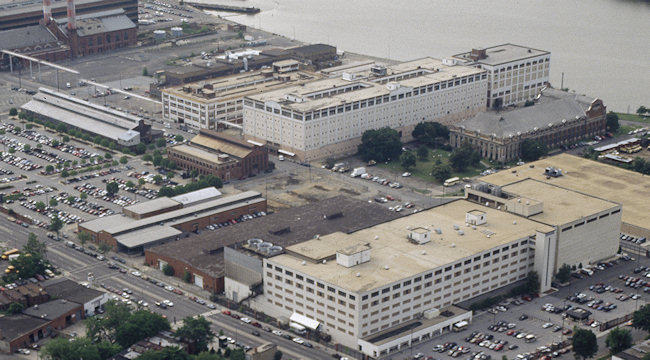
The Southeast Federal Center, showing buildings that are still standing as well as ones that were demolished around 1999-2000, including the two low-slung brick buildings right along M Street next to the old white NGA building, a brick annex to the red building at 3rd and Tingey behind what is now the US DOT HQ, and the large Building 159, nestled between the DC Water main pumping station and what is now the Foundry Lofts. Building 167, now the Boilermaker Shops, is visible at left center, and interestingly shows that the loading dock that has been added on the western end of the building at 3rd Street is an echo of a portion of the building that was there before.

On Half Street between K and L, you can see the J.E. Hurley Machine and Boiler Works site (see also a ground-level view of the building from around the same time). This became the Nation nightclub, then the 1015 Half Street office building.

The Half and M intersection, showing at left the newish entrance to the Navy Yard Metro station, before 55 M Street was built on top of it in 2007. At right is the WMATA Southeastern Bus Garage, which was vacated when Nationals Park opened one block to the south, then demolished in 2009.

The Capper/Carrollsburg public housing project, between K and M and 2nd and 7th. Most of these buildings were demolished between 2003 and 2007. At bottom you can see the school bus lots that eventually became Canal Park.

At center is New Jersey Avenue, running from K Street at left to M at right. The buildings between K and L, where Capitol Hill Tower now stands, were demolished between 2001 and 2003, as were the car repair shops at New Jersey and M, clearing that block for the 1100 New Jersey Avenue office building. At bottom along 1st Street are many buildings that existed until 2006-2011, including the Market Deli.
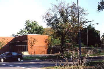
A ground-level view of the red brick building seen at left center in the above photo, taken in September 2000. (See what this corner looks like now.) (JD photo)
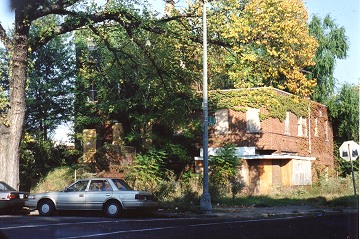
A ground-level image of the abandoned building at New Jersey and L, obscured by trees at the center of the above 1990s photo, taken in September 2000. (See what this corner looks like now.) (JD photo)

A ground-level image of the AAMCO station at New Jersey and M, taken in September 2000, on bad film, unfortunately. (JD photo)
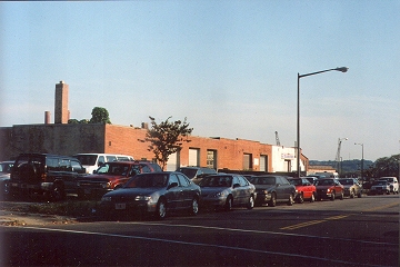
A ground-level image of the block's New Jersey Avenue frontage in September 2000, looking southeast toward M Street. (JD photo)
These four color images, provided to JDLand in early 2013 by a reader who was given the prints, show M Street SE during the time of the Navy Yard Metro construction station, probably in 1990 or early 1991.

Looking westward on M Street SE just east of 1st Street, in a photo clearly taken from was then the Defense Mapping Agency building. Starting at far left, you can see the Normandie Liquors store still in operation, with the WMATA Southeastern Bus Garage one block to the rear at Half Street. Moving to the right, lining the north side of M, is the empty parking lot at 20 M, the Sunoco station demolished in 2006, the Tracks night club in the long white building at 80 M (the volleyball courts are in the fenced-in area at rear), and the On Luck Cafeteria, demolished in 2007. If you look at the enlarged version, you'll also be able to see the J.E. Hurley Machine and Boiler Works building, before it was painted black and turned into Nation (and then was demolished to become 1015 Half Street). (donated photo, not by JD)

Turning the other way from the same DMA vantage point to look northeastward across M Street. Directly below is the construction of the east entrance of the Navy Yard Metro station, at New Jersey and M, and you can also see that M Street itself was merely a bunch of wooden boards (presumably from cut-and-cover construction). Directly to the north of the work site you can see beneath the trees the first of a series of rowhouses that used to stand there (scroll down to the first black and white photo on this page to see them in 1992). Across New Jersey are the AAMCO garage and rowhouses that stood until demolished by 2003 to make way for 1100 New Jersey Avenue. Then you have the infamous school buses on the Canal Park site, and then the many buildings making up Capper/Carrollsburg. And, to the right in the distance are the Ellen Wilson buildings just north of the freeway at 6th Street that were demolished in the mid-1990s as well as the high-rise Capper building demolished in 2004 at the site of what's now Capper Seniors #1. (Enlarged version here.) (donated photo, not by JD)

A zoomed look down M Street, in front of the old Southeast Federal Center site where the US Department of Transportation now stands, during the Metro construction. (donated photo, not by JD)

A peek into the construction of the Navy Yard Metro station. (donated photo, not by JD)
The following black and white images, taken in 1992, come from the massive National Park Service's HABS, HAER and HALS archive of photos, available online thanks to the Library of Congress. I have cropped the original images severely in order to highlight particular points of interest. The originals are from surveys of Virginia Avenue, New Jersey Avenue, and Potomac Avenue.

New Jersey Avenue SE at M street, showing mainly the western side of the block. At bottom center is the very tidy and new eastern entrance to the Navy Yard Metro station, which opened the previous year. At least seven townhouses, already boarded up, stand between the station plaza at St. Matthew's Church, at upper right. These townhouses were demolished some time before 2003. (See what it looks like now from ground level.) The buildings along the left side of the photo were demolished in 2006 to make way for both the Onyx apartment building and the 100 M Street office building.

A portion of what was then the Southeast Federal Center, as seen from the west. The large white building behind the ornate WASA main pumping station is Building 159, which was demolished in the 1999-2000 timeframe despite the desire of historic preservationists to save it. It stood on what is now the footprint of the Yards Park, and is obscuring the view of the Pattern Joiner Shop (Building 160) and the Lumber Storage Shed, both of which are still standing today. Most buildings in the forefront are part of WASA's operations and are still in use today, though this view would now be obscured by Nationals Park.

First Street SE at M Street. Another image of the Tracks nightclub, seen on the left side of First Street; it operated from 1984 to 1999. That block is now home to the 80 M Street office building (see what it looks like now from ground level). Across the street, at the corner at lower right, is the On Luck carryout, demolished along with its neighbors in 2006 to make way for the 100 M Street office building (see what it looks like now from ground level).

This photo, looking west from above 11th Street SE, is notable mainly for showing the four high-rise Capper buildings along Seventh Street and Virginia Avenue that were demolished in 2000 and that I never photographed. (The fifth, at upper right, was demolished in 2004.) You can see how K Street, at mid-left, still ran through from Fifth to Seventh; it was blocked off sometime before 2003. That large block is now home to both a Marine barracks and the new Capper Seniors building completed in 2006. At left is the old Capper Seniors building, demolished in late 2007. Most of the buildings in the foreground are unchanged from what is seen here.

Square 740, the block bounded by New Jersey, L (foreground), Second, and K. The building on the north edge of the block was a DC public schools warehouse, and was demolished sometime between 2000 and 2003. The townhouses, already boarded up in this image, were mostly demolished by 2000. This block is now home to the Courtyard by Marriott hotel and Capitol Hill Tower co-op building. (See what this block looks like now; also, a slightly different angle to the one above, taken the same day.)

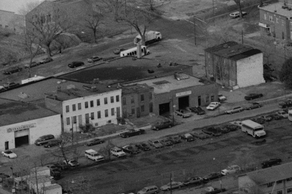
Square 742, bounded by New Jersey, M, Second, and L streets SE. The block was home mainly to auto garages and a few rowhouses in disrepair. The block is now home to the 1100 New Jersey Avenue ("Federal Gateway") office building, completed in 2004. The building is home to Five Guys, Subway, CVS, and Chevy Chase Bank. (See what this corner looks like now.)

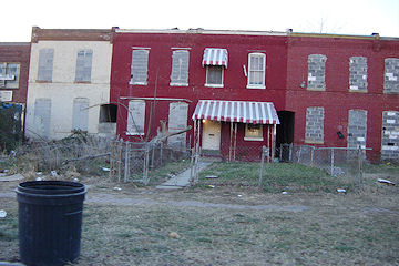
Square 738, bounded by New Jersey, K, First, and I streets SE. The building at the north end of the block was at this point either still the notorious Chapter III nightclub, or about to become the Mirage; by 2003 it was the Nexus Gold Club. The townhouses at center were mostly boarded up by 2003.
A similar view to the one above, from March 2006. Sometime before 2000 the auto garage at lower left was built. (JD photo)

And the same angle, from March 2010. The entire block except for the garage was demolished in 2007 to make way for the 909 New Jersey apartment building. (JD photo)

A heavily cropped image show the blocks around First (at right), Half, I (top), and L (bottom). At the absolute far lower left is a smidgen of the building at 1015 Half Street, which appears to still be operating as the Hurley Boiler company, though the building would be auctioned off later in 1992. It then beceme the Capitol Ballroom in 1995, then Nation in 1995, operating until it was closed in 2007 to make way for a new office building. The other buildings appear mostly unchanged from what I began photographing in 2003, except for the smokestack rising from the building at left center at the corner of Half and I, which was home to a towing company when it was demolished in 2008. At lower left/center you can see the entrances to the nightclubs that in 1992-ish were Lost & Found and the Zone; before long they would become Wet (1999) and Edge (1993). The entire block was demolished in 2006 to make way for Velocity. At the extreme bottom right is the Market Deli, which was demolished in 2011.

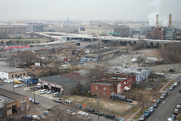
Squares 737 and 739, between New Jersey Avenue and Second Street, just south of the Southeast Freeway. The trash transfer station on the south end is being demolished in 2012; to its north stood a Washington Star/Post warehouse. The white building was much more ornate and interesting than it appears here, and I'm mainly including it because I weep every time I see it and remember that I didn't photograph it before it was demolished in 2000. The two blocks will eventually be redeveloped, with the northern half becoming a 1.1 million square foot residential project and the trash transfer site becoming a mixed-income apartment building.

The Washington Gas and Steuart Oil sites on the east end of M Street, bounded by the SE Freeway ramps to Pennsylvania Avenue and the 11th Street Bridges. By 2003 the open field at top center was home to Maritime Plaza buildings I and II; the triangular lot seen here with huge tanks may someday be an 800,000-square-foot mixed use development.