
|
| |||||||||||||||||||

|
Please note that JDLand is no longer being updated.
Historic Photos of Near Southeast
Note: I did not take any of these photos.
I link to the original site where possible (respecting copyright!).
- Full Neighborhood Development MapThere's a lot more than just the projects listed here. See the complete map of completed, underway, and proposed projects all across the neighborhood.
- What's New This YearA quick look at what's arrived or been announced since the end of the 2018 baseball season.
- Food Options, Now and Coming SoonThere's now plenty of food options in the neighborhood. Click to see what's here, and what's coming.
![-]()
- Anacostia RiverwalkA bridge between Teague and Yards Parks is part of the planned 20-mile Anacostia Riverwalk multi-use trail along the east and west banks of the Anacostia River.
![-]()
- Virginia Ave. Tunnel ExpansionConstruction underway in 2015 to expand the 106-year-old tunnel to allow for a second track and double-height cars. Expected completion 2018.
![-]()
- Rail and Bus Times
Get real time data for the Navy Yard subway, Circulator, Bikeshare, and bus lines, plus additional transit information. - Rail and Bus Times
Get real time data for the Navy Yard subway, Circulator, Bikeshare, and bus lines, plus additional transit information. - Canal ParkThree-block park on the site of the old Washington Canal. Construction begun in spring 2011, opened Nov. 16, 2012.
![-]()
- Nationals Park21-acre site, 41,000-seat ballpark, construction begun May 2006, Opening Day March 30, 2008.
![-]()
- Washington Navy YardHeadquarters of the Naval District Washington, established in 1799.
![-]()
- Yards Park5.5-acre park on the banks of the Anacostia. First phase completed September 2010.
![-]()
- Van Ness Elementary SchoolDC Public School, closed in 2006, but reopening in stages beginning in 2015.
![-]()
- Agora/Whole Foods336-unit apartment building at 800 New Jersey Ave., SE. Construction begun June 2014, move-ins underway early 2018. Whole Foods expected to open in late 2018.
![-]()
- New Douglass BridgeConstruction underway in early 2018 on the replacement for the current South Capitol Street Bridge. Completion expected in 2021.
![-]()
- 1221 Van290-unit residential building with 26,000 sf retail. Underway late 2015, completed early 2018.

- NAB HQ/AvidianNew headquarters for National Association of Broadcasters, along with a 163-unit condo building. Construction underway early 2017.

- Yards/Parcel O Residential ProjectsThe Bower, a 138-unit condo building by PN Hoffman, and The Guild, a 190-unit rental building by Forest City on the southeast corner of 4th and Tingey. Underway fall 2016, delivery 2018.

- New DC Water HQA wrap-around six-story addition to the existing O Street Pumping Station. Construction underway in 2016, with completion in 2018.

- The Harlow/Square 769N AptsMixed-income rental building with 176 units, including 36 public housing units. Underway early 2017, delivery 2019.

- West Half Residential420-unit project with 65,000 sf retail. Construction underway spring 2017.
![-]()
- Novel South Capitol/2 I St.530ish-unit apartment building in two phases, on old McDonald's site. Construction underway early 2017, completed summer 2019.
![Novel South Capitol]()
- 1250 Half/Envy310 rental units at 1250, 123 condos at Envy, 60,000 square feet of retail. Underway spring 2017.
![-]()
- Parc Riverside Phase II314ish-unit residential building at 1010 Half St., SE, by Toll Bros. Construction underway summer 2017.
![-]()
- 99 M StreetA 224,000-square-foot office building by Skanska for the corner of 1st and M. Underway fall 2015, substantially complete summer 2018. Circa and an unnamed sibling restaurant announced tenants.
![-]()
- The Garrett375-unit rental building at 2nd and I with 13,000 sq ft retail. Construction underway late fall 2017.
![-]()
- Yards/The Estate Apts. and Thompson Hotel270-unit rental building and 227-room Thompson Hotel, with 20,000 sq ft retail total. Construction underway fall 2017.
![-]()
- Meridian on First275-unit residential building, by Paradigm. Construction underway early 2018.
![-]()
- The Maren/71 Potomac264-unit residential building with 12,500 sq ft retail, underway spring 2018. Phase 2 of RiverFront on the Anacostia development.
![-]()
- DC Crossing/Square 696Block bought in 2016 by Tishman Speyer, with plans for 800 apartment units and 44,000 square feet of retail in two phases. Digging underway April 2018.
![DC Crossing]()
- One Hill South Phase 2300ish-unit unnamed sibling building at South Capitol and I. Work underway summer 2018.
![One Hill South Phase 2]()
- New DDOT HQ/250 MNew headquarters for the District Department of Transportation. Underway early 2019.
![New DDOT HQ]()
- 37 L Street Condos11-story, 74-unit condo building west of Half St. Underway early 2019.
![37 L Condos]()
- CSX East Residential/Hotel225ish-unit AC Marriott and two residential buildings planned. Digging underway late summer 2019.
![CSX East Residential/Hotel]()
- 1000 South Capitol Residential224-unit apartment building by Lerner. Underway fall 2019.
![1000 South Capitol Residential]()
- Capper Seniors 2.0Reconstruction of the 160-unit building for low-income seniors that was destroyed by fire in 2018.
![1000 South Capitol Residential]()
- Chemonics HQNew 285,000-sq-ft office building with 14,000 sq ft of retail. Expected delivery 2021.
![1000 South Capitol Residential]()


Many of these photos are from the Library of Congress American Memory Collection and Dave's Electric Railroads; if you're interested in DC historical photos, there's a lot of them on these sites to browse and search. And the official web site for The Yards includes a page devoted to the long history of what used to be the Navy Yard Annex and the Southeast Federal Center. In addition, the District Department of Transportation has begun posting photos from its archives.
Visit the DC Public Library's Washingtoniana room in person to browse scads of historic photos and documents.
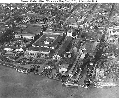
An overhead view of the Washington Navy Yard in 1918, along with the areas north of M Street. From the Washington Navy Yard Naval Historical Center, where you can also view many additional photos and paintings of the Navy Yard through history. (1918)
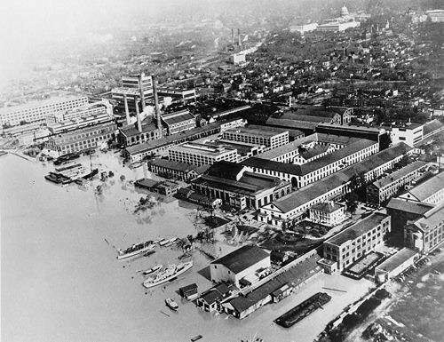
A view of the Navy Yard and points north during a 1936 flood. From the Library of Congress Historic American Buildings Survey; this collection has many, many, many old photos and drawings and descriptions of the Navy Yard. Visit the American Memory home page, and search on "Navy Yard DC" to browse them.
.%20AERIAL%20VIEW%20OF%20THE%20NAVY%20YARD%20DURING%20THE%201936%20FLOOD.%20VIEW%20LOOKING%20NORTHWEST.%20BUILDING%2036,%20JUST%20RIGHT%20OF%20CENTER,%20CONSISTS%20OF%20THE%20EAST%20AND%20NORTH%20WINGS%20OF%20THE%20QUADRANGLE%20STRUCTURE.%20%3cbr%3eHABS%20DC,WASH,74-F-35&displayProfile=0)
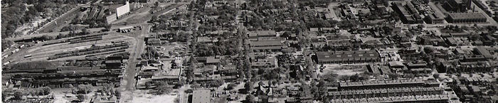
An overhead view from 1939 of the western portion of Near Southeast. The grand South Capitol Street that we know today doesn't exist here, but would run horizontally through the middle of the photo. Virginia Avenue is at far left (remember, this is before the freeway was built); then the railyards (now the location of 70/100 I Street), which front I Street. You can see the old white warehouse at upper left which today is the parking lot at 2nd and H. The streets from left are Virginia Ave., I Street, K Street, L Street, M Street, and N Street, so the very far right of the photo is where Nationals Park was built. On the south side of M Street, you can see what was the WMATA Southeastern Bus Garage. From the files of the old DC Alley Dwelling Authority, now held by the DC Housing Authority. (1939)
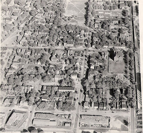
Another overhead view of Near Southeast from 1939, with M Street running along the right edge of the photo, and I Street and then Virginia Avenue at far left. Running across the bottom of the photo is the site of Canal Park. At the corner of 4th and M, on the site of what is now 300 M Street, is the original Van Ness school building, which operated until 1956 when it was replaced. The open field at top center is about where the new Marine Bachelor Enlisted Quarters' field is now located, along with the now-torn down Capper Community Center. This is all before Capper/Carrollsburg was built. From the files of the old DC Alley Dwelling Authority, now held by the DC Housing Authority. (1939)
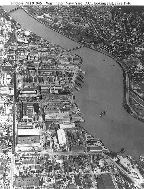
Looking at the Navy Yard Annex and the Navy Yard from above South Capitol Street, in 1946. This shows what we've come to know as the Southeast Federal Center back when it had many more buildings, at the time when the Navy Yard stretched all the way to First Street. At the bottom left of the photo is the WMATA Southeastern Bus Garage; the rest of the lower portion of the photo is where the Nationals ballpark is now being built. Old Capper Seniors is at upper right. Capper/Carrollsburg buildings at left. From the Washington Navy Yard Naval Historical Center, where you can also view many additional photos and paintings of the Navy Yard through history. (1946)
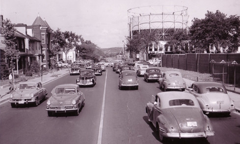
Looking east on M Street, near 10th Street, circa 1949. The storage tank at right is believed to be on the Washington Gas site, so perhaps the cross street is 11th Street, with the brick wall at right being the Navy Yard. If you look at the photo above this one, the 1946 overhead view of the Navy Yard, you can see this storage tank. From the District Department of Transportation Historical Photo Archives; visit their page for a larger version of this photo. (1949)
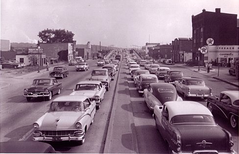
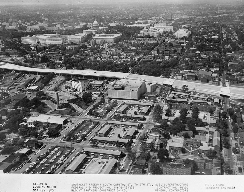
Looking south down South Capitol Street, south of N Street, circa 1957, soon after the opening of the Frederick Douglass Bridge. From the District Department of Transportation Historical Photo Archives; visit their page for a larger version of this photo. You can also see my photos from this same vantage point since 2005. (1957)
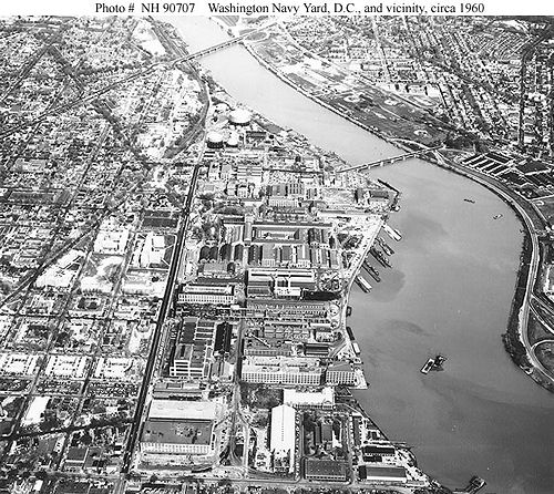
Another overhead view of the Navy Yard Annex and the Washington Navy Yard, around 1960, along with the areas north of M Street. You can also see Capper/Carrollsburg buildings at left. From the Washington Navy Yard Naval Historical Center, where you can also view many additional photos and paintings of the Navy Yard through history. (1960)
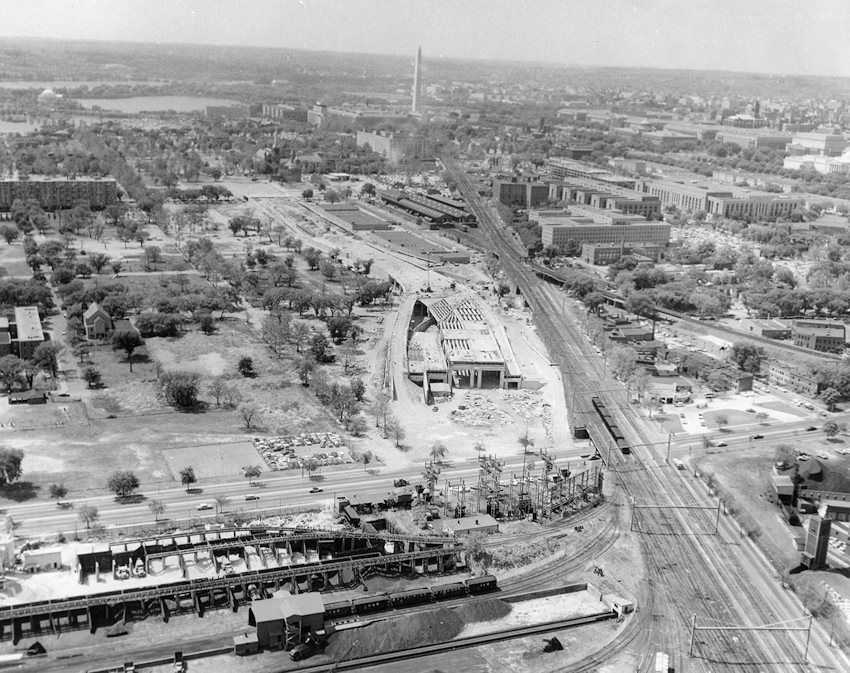
Another DDOT photo from 1965, this time looking west from just east of South Capitol Street at the beginnings of construction of the Southwest Freeway. (So, not really showing much Near Southeast, but it's still cool.)
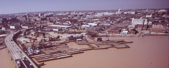
Looking into Near Southeast from above a very muddy Anacostia River, in April 1973. The Douglass Bridge runs below, with the Florida Rock site, the pumphouse at what's now Diamond Teague Park, and the DC Water land being closest to shore. The many light industrial buildings on what became the Nationals Park footprint are also visible. See the full-sized version, via the National Archives. (1973)
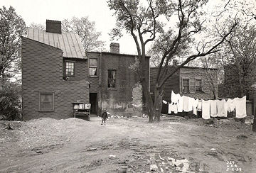
A 1939 photo of the rear of the houses that used to stand at 1009-1013 5th Street, SE, that were eventually torn down to make way for the Capper/Carrollsburg project, now itself torn down. From the files of the old DC Alley Dwelling Authority, now held by the DC Housing Authority. (1939)
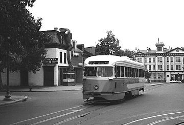
A photo showing one of DC's old streetcars, looking down 8th Street from just north of L Street, toward the Latrobe Gate of the Navy Yard. The buildings at left today house Chicken Tortilla and the Port Cafe. From the Dave's Rail Pix web site. (undated)
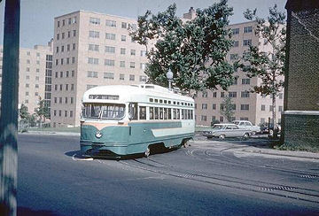
One of DC's old streetcars turning onto M Street from 7th Street, in July 1961, on its way to the garage at 8th and M now known as the "Blue Castle." The old Capper Seniors building is at rear. From the Dave's Rail Pix web site. (7/1961)
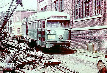
Another streetcar shot, showing an old car scrapped on L Street behind what is now known as the "Blue Castle." You can recognize at rear the building that is now the 7th and L Market. From the Dave's Rail Pix web site. (5/24/1963)