
|
| |||||||||||||||||||

|
Please note that JDLand is no longer being updated.
peek >>
Developer: Forest City Washington /GSA | Lead Office Architect: Shalom Baranes Associates
Southeast Federal Public-Private Development Act | SFC Zoning Overlay | Yards Groundbreaking (10/3/07)
The Yards
The redevelopment of the old Southeast Federal Center; first project underway in 2008
42 acres, 1.8 million sq ft office space, 2,800 residential units, 160,000-350,000 sq ft retail, and a 5.8-acre riverfront park
Developer: Forest City Washington /GSA | Lead Office Architect: Shalom Baranes Associates
Southeast Federal Public-Private Development Act | SFC Zoning Overlay | Yards Groundbreaking (10/3/07)
Individual Yards Projects:
Yards Park | Foundry Lofts | Boilermaker Shops | Twelve12 Apartments
Arris Apartments | Movie Theater/Apartments | Parcel A/Old NGA Site | Parcel O Condos/Apts | Parcel L Apartments/Hotel
Yards Park | Foundry Lofts | Boilermaker Shops | Twelve12 Apartments
Arris Apartments | Movie Theater/Apartments | Parcel A/Old NGA Site | Parcel O Condos/Apts | Parcel L Apartments/Hotel
- Full Neighborhood Development MapThere's a lot more than just the projects listed here. See the complete map of completed, underway, and proposed projects all across the neighborhood.
- What's New This YearA quick look at what's arrived or been announced since the end of the 2018 baseball season.
- Food Options, Now and Coming SoonThere's now plenty of food options in the neighborhood. Click to see what's here, and what's coming.
![-]()
- Anacostia RiverwalkA bridge between Teague and Yards Parks is part of the planned 20-mile Anacostia Riverwalk multi-use trail along the east and west banks of the Anacostia River.
![-]()
- Virginia Ave. Tunnel ExpansionConstruction underway in 2015 to expand the 106-year-old tunnel to allow for a second track and double-height cars. Expected completion 2018.
![-]()
- Rail and Bus Times
Get real time data for the Navy Yard subway, Circulator, Bikeshare, and bus lines, plus additional transit information. - Rail and Bus Times
Get real time data for the Navy Yard subway, Circulator, Bikeshare, and bus lines, plus additional transit information. - Canal ParkThree-block park on the site of the old Washington Canal. Construction begun in spring 2011, opened Nov. 16, 2012.
![-]()
- Nationals Park21-acre site, 41,000-seat ballpark, construction begun May 2006, Opening Day March 30, 2008.
![-]()
- Washington Navy YardHeadquarters of the Naval District Washington, established in 1799.
![-]()
- Yards Park5.5-acre park on the banks of the Anacostia. First phase completed September 2010.
![-]()
- Van Ness Elementary SchoolDC Public School, closed in 2006, but reopening in stages beginning in 2015.
![-]()
- Agora/Whole Foods336-unit apartment building at 800 New Jersey Ave., SE. Construction begun June 2014, move-ins underway early 2018. Whole Foods expected to open in late 2018.
![-]()
- New Douglass BridgeConstruction underway in early 2018 on the replacement for the current South Capitol Street Bridge. Completion expected in 2021.
![-]()
- 1221 Van290-unit residential building with 26,000 sf retail. Underway late 2015, completed early 2018.

- NAB HQ/AvidianNew headquarters for National Association of Broadcasters, along with a 163-unit condo building. Construction underway early 2017.

- Yards/Parcel O Residential ProjectsThe Bower, a 138-unit condo building by PN Hoffman, and The Guild, a 190-unit rental building by Forest City on the southeast corner of 4th and Tingey. Underway fall 2016, delivery 2018.

- New DC Water HQA wrap-around six-story addition to the existing O Street Pumping Station. Construction underway in 2016, with completion in 2018.

- The Harlow/Square 769N AptsMixed-income rental building with 176 units, including 36 public housing units. Underway early 2017, delivery 2019.

- West Half Residential420-unit project with 65,000 sf retail. Construction underway spring 2017.
![-]()
- Novel South Capitol/2 I St.530ish-unit apartment building in two phases, on old McDonald's site. Construction underway early 2017, completed summer 2019.
![Novel South Capitol]()
- 1250 Half/Envy310 rental units at 1250, 123 condos at Envy, 60,000 square feet of retail. Underway spring 2017.
![-]()
- Parc Riverside Phase II314ish-unit residential building at 1010 Half St., SE, by Toll Bros. Construction underway summer 2017.
![-]()
- 99 M StreetA 224,000-square-foot office building by Skanska for the corner of 1st and M. Underway fall 2015, substantially complete summer 2018. Circa and an unnamed sibling restaurant announced tenants.
![-]()
- The Garrett375-unit rental building at 2nd and I with 13,000 sq ft retail. Construction underway late fall 2017.
![-]()
- Yards/The Estate Apts. and Thompson Hotel270-unit rental building and 227-room Thompson Hotel, with 20,000 sq ft retail total. Construction underway fall 2017.
![-]()
- Meridian on First275-unit residential building, by Paradigm. Construction underway early 2018.
![-]()
- The Maren/71 Potomac264-unit residential building with 12,500 sq ft retail, underway spring 2018. Phase 2 of RiverFront on the Anacostia development.
![-]()
- DC Crossing/Square 696Block bought in 2016 by Tishman Speyer, with plans for 800 apartment units and 44,000 square feet of retail in two phases. Digging underway April 2018.
![DC Crossing]()
- One Hill South Phase 2300ish-unit unnamed sibling building at South Capitol and I. Work underway summer 2018.
![One Hill South Phase 2]()
- New DDOT HQ/250 MNew headquarters for the District Department of Transportation. Underway early 2019.
![New DDOT HQ]()
- 37 L Street Condos11-story, 74-unit condo building west of Half St. Underway early 2019.
![37 L Condos]()
- CSX East Residential/Hotel225ish-unit AC Marriott and two residential buildings planned. Digging underway late summer 2019.
![CSX East Residential/Hotel]()
- 1000 South Capitol Residential224-unit apartment building by Lerner. Underway fall 2019.
![1000 South Capitol Residential]()
- Capper Seniors 2.0Reconstruction of the 160-unit building for low-income seniors that was destroyed by fire in 2018.
![1000 South Capitol Residential]()
- Chemonics HQNew 285,000-sq-ft office building with 14,000 sq ft of retail. Expected delivery 2021.
![1000 South Capitol Residential]()


A July 2016 graphic showing the footprint of, progress at, and future plans for the 42-acre site along the Anacostia River known as "The Yards."

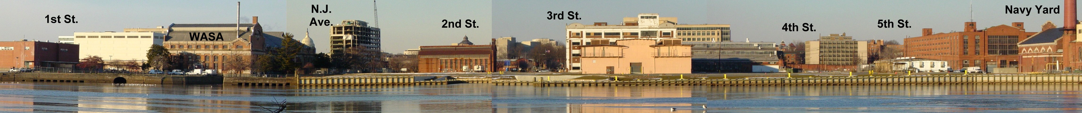
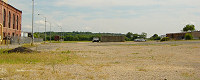
The size of the Yards footprint is clearest when viewed from across the Anacostia, seen here back in January 2003 before the start of the US DOT HQ construction. (see enlargement) (01/03)
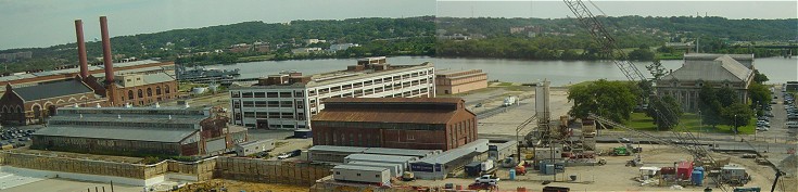
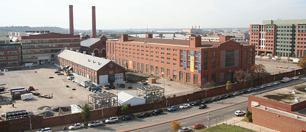
The opposite side view of the central portion of The Yards, from above M Street, seen in September 2004 (before the Department of Transportation HQ obscured the view). The historic red brick building at center, along with the open plaza area to its right, are part of the DOT site; the ornate building at right is a WASA pumping plant; and the two red brick buildings at the far left are part of the Navy Yard. All other areas and buildings in this photo are considered part of the The Yards. (09/04)
|
Yards Projects Completed, Underway, and Planned for the Near Term | ||
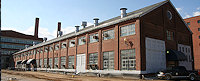
| Foundry Lofts (the old Parcel M/Pattern-Joiner Shop/Building 160) - The brown-and-white building at 3th and Tingey, it has been renovated as a 170-unit apartment building, with two floors added on top; work began in 2008, but stalled until August 2010 because of funding issues. The first residents moved in in November 2011. | |
| Yards Park - A 5.5 acre park along The Yards's riverfront, its first phase opened in September 2010. A bridge--part of the Anacostia Riverwalk--connecting the park to Diamond Teague Park opened in November 2011. | |
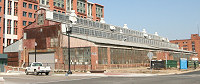
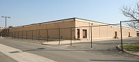
| The Boilermaker Shop (the old Parcel K/Building 167) - The building on the north side of Tingey, between 3rd and 4th and just behind the Department of Transportation HQ, has been redeveloped as a retail building; work got underway in fall 2011, with with tenants moving in throughout 2013. | |
| The Lumber Shed - The historic building is being renovated as a restaurant pavilion, with its location at the north end of the Yards Park area making it easily available to users of the Anacostia Riverwalk. Construction began in summer 2012, with initial tenants opening late in 2013. | |
| Twelve12/Parcel D - An empty lot for many years, this site was redesigned in 2010 to be a residential building with 200-225 units, a ground-floor Harris Teeter, and a three-story fitness center and spa. Construction began in early 2012, and opened in 2014. | |
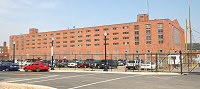
| Arris/Parcel N - Work began in late 2013 on the Yards's second new-construction apartment building, with 327 units and 20,000 sq ft of retail on the southwest corner of 4th and Tingey. It opened in early 2016. | |
| Parcel O - The southeast corner of 4th and Tingey, formerly the temporary home to a trapeze school, is expected to see construction start in 2016 on a 140-unit condo building and 190-unit apartment building. | |
| Parcel L - The lot south of Tingey and west of 3rd will eventually have a 290-unit residential building and perhaps a boutique hotel. Residential construction could start by 2018. | |
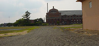
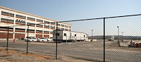
The northeastern footprint of the Yards, nestled between the Navy Yard, M Street, and the DOT HQ. The large building is the Broadside Mount Shop, formerly home to the Federal Protective Services, which will be renovated into a 270-unit condo building. The smaller brick building (Building 74) and the parking lots surrounding it will become residential areas in later phases of the site's development. (11/1/07)
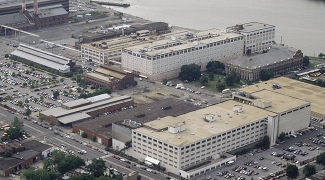
Not one of my photos, but a great zoom-in on a 1990s-era overhead photo showing the Southeast Federal Center as it looked until just a few years before I started photographing the neighborhood. Familiar buildings such as the now-Foundry Lofts building, the now-Boilermaker Shops building, the former NGA building at 1st and M, and the DC Water main pumping station are interspersed with buildings that were demolished around 1999, including the large white Building 159 and smaller low-slung warehouse-type buildings at New Jersey and M and east of the Foundry Lofts. The large parking lot at far left is where the US Department of Transportation building now stands.
From the Carol M. Highsmith Archive, Library of Congress, Prints and Photographs Division.
Later Phases
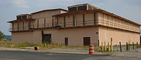
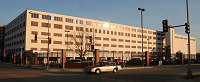
| Factory 202/Parcel E1/Building 202/Gun Assembly Shop/Gun Mount Shop - The red brick building at 5th and M was once slated to be redeveloped as a 271-unit condo building, but Forest City put it on the market in 2016 to assess potential other development ideas. | |
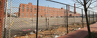
| Parcels A, F, G - This site at 1st and M was home to the National Geospatial-Intelligence Agency (and other cloak-and-dagger Feds) until 2011, and the building was finally demolished in spring 2014. These parcels will be redeveloped as office buildings, with ground-floor retail, but is in the meantime becoming a public space some wags refer to as "Spooky Park." | |
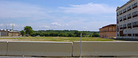
| Parcels H and I - Land along 1st Street south of Tingey was cleared in early 2008 to allow parking for Nationals Park. Eventually, in later phases, residential buildings will be built here. | |
| Parcels D and E2/3 - The additional parcels on the northeast corner of the site will be turned into residential projects. |
Latest News
February 18, 2020
Albi Opening This Week, Five of the Very Best, and Square Pizza
November 20, 2019
Wednesday Tidbits: Whaley's Closing, Something Opening, Enchant
November 7, 2019
Catching Up on Digging and Skeletoning, Fall 2019 Edition
October 29, 2019
Tuesday Tidbits: Avoiding Thoughts of Houston for a Moment
August 18, 2019
August Tidbit Roundup and Open Thread
July 19, 2019
Tidbits: Lazy Hazy Heat-Emergency Days of Summer
January 9, 2019
Yards Movie Theater Plans Lose Showplace Icon as Operator