
|
| |||||||||||||||||||

|
Please note that JDLand is no longer being updated.
peek >>
Near Southeast DC Past News Items: Nov 13, 2010
- Full Neighborhood Development MapThere's a lot more than just the projects listed here. See the complete map of completed, underway, and proposed projects all across the neighborhood.
- What's New This YearA quick look at what's arrived or been announced since the end of the 2018 baseball season.
- Food Options, Now and Coming SoonThere's now plenty of food options in the neighborhood. Click to see what's here, and what's coming.
![-]()
- Anacostia RiverwalkA bridge between Teague and Yards Parks is part of the planned 20-mile Anacostia Riverwalk multi-use trail along the east and west banks of the Anacostia River.
![-]()
- Virginia Ave. Tunnel ExpansionConstruction underway in 2015 to expand the 106-year-old tunnel to allow for a second track and double-height cars. Expected completion 2018.
![-]()
- Rail and Bus Times
Get real time data for the Navy Yard subway, Circulator, Bikeshare, and bus lines, plus additional transit information. - Rail and Bus Times
Get real time data for the Navy Yard subway, Circulator, Bikeshare, and bus lines, plus additional transit information. - Canal ParkThree-block park on the site of the old Washington Canal. Construction begun in spring 2011, opened Nov. 16, 2012.
![-]()
- Nationals Park21-acre site, 41,000-seat ballpark, construction begun May 2006, Opening Day March 30, 2008.
![-]()
- Washington Navy YardHeadquarters of the Naval District Washington, established in 1799.
![-]()
- Yards Park5.5-acre park on the banks of the Anacostia. First phase completed September 2010.
![-]()
- Van Ness Elementary SchoolDC Public School, closed in 2006, but reopening in stages beginning in 2015.
![-]()
- Agora/Whole Foods336-unit apartment building at 800 New Jersey Ave., SE. Construction begun June 2014, move-ins underway early 2018. Whole Foods expected to open in late 2018.
![-]()
- New Douglass BridgeConstruction underway in early 2018 on the replacement for the current South Capitol Street Bridge. Completion expected in 2021.
![-]()
- 1221 Van290-unit residential building with 26,000 sf retail. Underway late 2015, completed early 2018.

- NAB HQ/AvidianNew headquarters for National Association of Broadcasters, along with a 163-unit condo building. Construction underway early 2017.

- Yards/Parcel O Residential ProjectsThe Bower, a 138-unit condo building by PN Hoffman, and The Guild, a 190-unit rental building by Forest City on the southeast corner of 4th and Tingey. Underway fall 2016, delivery 2018.

- New DC Water HQA wrap-around six-story addition to the existing O Street Pumping Station. Construction underway in 2016, with completion in 2018.

- The Harlow/Square 769N AptsMixed-income rental building with 176 units, including 36 public housing units. Underway early 2017, delivery 2019.

- West Half Residential420-unit project with 65,000 sf retail. Construction underway spring 2017.
![-]()
- Novel South Capitol/2 I St.530ish-unit apartment building in two phases, on old McDonald's site. Construction underway early 2017, completed summer 2019.
![Novel South Capitol]()
- 1250 Half/Envy310 rental units at 1250, 123 condos at Envy, 60,000 square feet of retail. Underway spring 2017.
![-]()
- Parc Riverside Phase II314ish-unit residential building at 1010 Half St., SE, by Toll Bros. Construction underway summer 2017.
![-]()
- 99 M StreetA 224,000-square-foot office building by Skanska for the corner of 1st and M. Underway fall 2015, substantially complete summer 2018. Circa and an unnamed sibling restaurant announced tenants.
![-]()
- The Garrett375-unit rental building at 2nd and I with 13,000 sq ft retail. Construction underway late fall 2017.
![-]()
- Yards/The Estate Apts. and Thompson Hotel270-unit rental building and 227-room Thompson Hotel, with 20,000 sq ft retail total. Construction underway fall 2017.
![-]()
- Meridian on First275-unit residential building, by Paradigm. Construction underway early 2018.
![-]()
- The Maren/71 Potomac264-unit residential building with 12,500 sq ft retail, underway spring 2018. Phase 2 of RiverFront on the Anacostia development.
![-]()
- DC Crossing/Square 696Block bought in 2016 by Tishman Speyer, with plans for 800 apartment units and 44,000 square feet of retail in two phases. Digging underway April 2018.
![DC Crossing]()
- One Hill South Phase 2300ish-unit unnamed sibling building at South Capitol and I. Work underway summer 2018.
![One Hill South Phase 2]()
- New DDOT HQ/250 MNew headquarters for the District Department of Transportation. Underway early 2019.
![New DDOT HQ]()
- 37 L Street Condos11-story, 74-unit condo building west of Half St. Underway early 2019.
![37 L Condos]()
- CSX East Residential/Hotel225ish-unit AC Marriott and two residential buildings planned. Digging underway late summer 2019.
![CSX East Residential/Hotel]()
- 1000 South Capitol Residential224-unit apartment building by Lerner. Underway fall 2019.
![1000 South Capitol Residential]()
- Capper Seniors 2.0Reconstruction of the 160-unit building for low-income seniors that was destroyed by fire in 2018.
![1000 South Capitol Residential]()
- Chemonics HQNew 285,000-sq-ft office building with 14,000 sq ft of retail. Expected delivery 2021.
![1000 South Capitol Residential]()


2 Blog Posts
I read a few days ago about how the New York Daily News is using Foursquare to drive mobile users to its vast archive of historical NYC images, and I started thinking about my own sightly-less-vast archive of photos I've taken of Near Southeast since 2000, and what I could do with them in a mobile-y kind of way. I figured that what people would be most interested in would be to see what a certain spot looked like before all of the redevelopment started happening. And wouldn't be neat if you didn't have to input your location, but if it was determined via your phone's GPS?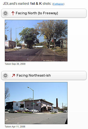 So I threw something together, delving for the first time into both HTML5 and the still-in-alpha JQueryMobile, and it seems to actually work, at least on newer smartphones, though I make no guarantees. (Haven't tried it on older ones.)
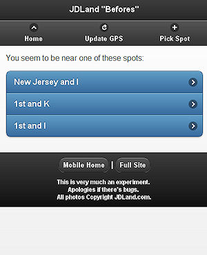
So I threw something together, delving for the first time into both HTML5 and the still-in-alpha JQueryMobile, and it seems to actually work, at least on newer smartphones, though I make no guarantees. (Haven't tried it on older ones.) How to use it? Stand on a street corner in Near Southeast, then go to jdland.com/here. If your phone has GPS, it will first ask you for permission to access your location data, then will lock on your location and bring up a page showing the oldest photo in my archive for eight compass points at that intersection.
Walk to another intersection, hit "Update GPS," and it'll show you a new set. If you're too far from an intersection, it'll ask you to confirm which one you want.
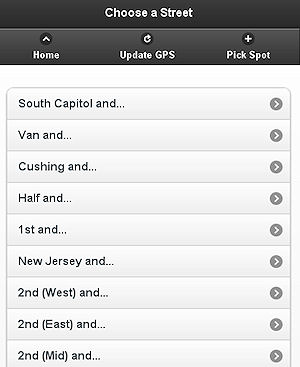
If your phone only uses the less-accurate methods of celltower triangulation or a WiFi signal to determine your approximate location, this app will show you what it thinks the closest intersections are, and you can choose which one to view. Or, if the GPS stuff just isn't working at all, you can browse to the intersection you want to see. (This will be what you'll have to do when you're trying it from your desktop computer, which I know everyone is racing to do right now--note that the pages will only work in Chrome and Firefox but not IE on desktops/laptops.)
It's kind of rudimentary in the display of the photos (yes, it'd be nice to show just one, based on the direction you're looking), but considering I only came up with the notion about 72 hours ago, it's not bad. I also have to ponder how to get these photos via location-awareness to people who are in the neighborhood but don't already know about JDLand, but that will come.
I've written a bit more about the app here--and note that, while I'm calling it an "app," it's just web pages, so it doesn't require a download.
That url again is jdland.com/here, or you can just go to m.jdland.com and follow the link at the top of the page. If you try it out, let me know how it goes. If it doesn't quite work for you, I apologize: it is, after all, something I just tossed together on a whim.
PS: Of course, all my photos since 2000 are available in my full archive whenever you feel like plowing through them, searchable by location and/or date. And maybe when DDOT releases Near Southeast images from its photo archive, I'll add a way to see those as well, but will wait for critical mass on that batch.
|
Comments (0)
More posts:
JDLand stuff
|
City Paper's Housing Complex blog reported late Friday afternoon that DDOT has decided to put in a "Barnes Dance" configuration (also known as a pedestrian scramble) at New Jersey and M, SE, sometime early in 2011. This is the setup where traffic on all sides have a red light at the same time, allowing pedestrians to cross in any direction. The first one in DC was put in at 7th and H in Chinatown a few months ago. With so many people needing to cross diagonally to go between the Navy Yard Metro station entrance and USDOT, this is probably a good choice for another intersection to try it out.
(Though I do dream of a day far in the future, when Forest City builds an office building on the NGA site on the southwest corner of the intersection as part of the Yards, that that new construction would include an additional entrance to the Metro station, obviating the need for people on the south side of M to cross the street to get to the subway.)
|
Comments (0)
More posts:
Pedestrian/Cycling Issues, Traffic Issues
|