
|
| |||||||||||||||||||

|
Please note that JDLand is no longer being updated.
peek >>
Near Southeast DC Past News Items: Nov 09, 2010
- Full Neighborhood Development MapThere's a lot more than just the projects listed here. See the complete map of completed, underway, and proposed projects all across the neighborhood.
- What's New This YearA quick look at what's arrived or been announced since the end of the 2018 baseball season.
- Food Options, Now and Coming SoonThere's now plenty of food options in the neighborhood. Click to see what's here, and what's coming.
![-]()
- Anacostia RiverwalkA bridge between Teague and Yards Parks is part of the planned 20-mile Anacostia Riverwalk multi-use trail along the east and west banks of the Anacostia River.
![-]()
- Virginia Ave. Tunnel ExpansionConstruction underway in 2015 to expand the 106-year-old tunnel to allow for a second track and double-height cars. Expected completion 2018.
![-]()
- Rail and Bus Times
Get real time data for the Navy Yard subway, Circulator, Bikeshare, and bus lines, plus additional transit information. - Rail and Bus Times
Get real time data for the Navy Yard subway, Circulator, Bikeshare, and bus lines, plus additional transit information. - Canal ParkThree-block park on the site of the old Washington Canal. Construction begun in spring 2011, opened Nov. 16, 2012.
![-]()
- Nationals Park21-acre site, 41,000-seat ballpark, construction begun May 2006, Opening Day March 30, 2008.
![-]()
- Washington Navy YardHeadquarters of the Naval District Washington, established in 1799.
![-]()
- Yards Park5.5-acre park on the banks of the Anacostia. First phase completed September 2010.
![-]()
- Van Ness Elementary SchoolDC Public School, closed in 2006, but reopening in stages beginning in 2015.
![-]()
- Agora/Whole Foods336-unit apartment building at 800 New Jersey Ave., SE. Construction begun June 2014, move-ins underway early 2018. Whole Foods expected to open in late 2018.
![-]()
- New Douglass BridgeConstruction underway in early 2018 on the replacement for the current South Capitol Street Bridge. Completion expected in 2021.
![-]()
- 1221 Van290-unit residential building with 26,000 sf retail. Underway late 2015, completed early 2018.

- NAB HQ/AvidianNew headquarters for National Association of Broadcasters, along with a 163-unit condo building. Construction underway early 2017.

- Yards/Parcel O Residential ProjectsThe Bower, a 138-unit condo building by PN Hoffman, and The Guild, a 190-unit rental building by Forest City on the southeast corner of 4th and Tingey. Underway fall 2016, delivery 2018.

- New DC Water HQA wrap-around six-story addition to the existing O Street Pumping Station. Construction underway in 2016, with completion in 2018.

- The Harlow/Square 769N AptsMixed-income rental building with 176 units, including 36 public housing units. Underway early 2017, delivery 2019.

- West Half Residential420-unit project with 65,000 sf retail. Construction underway spring 2017.
![-]()
- Novel South Capitol/2 I St.530ish-unit apartment building in two phases, on old McDonald's site. Construction underway early 2017, completed summer 2019.
![Novel South Capitol]()
- 1250 Half/Envy310 rental units at 1250, 123 condos at Envy, 60,000 square feet of retail. Underway spring 2017.
![-]()
- Parc Riverside Phase II314ish-unit residential building at 1010 Half St., SE, by Toll Bros. Construction underway summer 2017.
![-]()
- 99 M StreetA 224,000-square-foot office building by Skanska for the corner of 1st and M. Underway fall 2015, substantially complete summer 2018. Circa and an unnamed sibling restaurant announced tenants.
![-]()
- The Garrett375-unit rental building at 2nd and I with 13,000 sq ft retail. Construction underway late fall 2017.
![-]()
- Yards/The Estate Apts. and Thompson Hotel270-unit rental building and 227-room Thompson Hotel, with 20,000 sq ft retail total. Construction underway fall 2017.
![-]()
- Meridian on First275-unit residential building, by Paradigm. Construction underway early 2018.
![-]()
- The Maren/71 Potomac264-unit residential building with 12,500 sq ft retail, underway spring 2018. Phase 2 of RiverFront on the Anacostia development.
![-]()
- DC Crossing/Square 696Block bought in 2016 by Tishman Speyer, with plans for 800 apartment units and 44,000 square feet of retail in two phases. Digging underway April 2018.
![DC Crossing]()
- One Hill South Phase 2300ish-unit unnamed sibling building at South Capitol and I. Work underway summer 2018.
![One Hill South Phase 2]()
- New DDOT HQ/250 MNew headquarters for the District Department of Transportation. Underway early 2019.
![New DDOT HQ]()
- 37 L Street Condos11-story, 74-unit condo building west of Half St. Underway early 2019.
![37 L Condos]()
- CSX East Residential/Hotel225ish-unit AC Marriott and two residential buildings planned. Digging underway late summer 2019.
![CSX East Residential/Hotel]()
- 1000 South Capitol Residential224-unit apartment building by Lerner. Underway fall 2019.
![1000 South Capitol Residential]()
- Capper Seniors 2.0Reconstruction of the 160-unit building for low-income seniors that was destroyed by fire in 2018.
![1000 South Capitol Residential]()
- Chemonics HQNew 285,000-sq-ft office building with 14,000 sq ft of retail. Expected delivery 2021.
![1000 South Capitol Residential]()


1 Blog Posts
At Monday's ANC 6D meeting, Bryon Johnston of the 11th Street Bridges Project gave a presentation on the rebuilding of the bridges, including an overview of the design and its main features as well as an update on the construction progress. He was nice enough to pass along the slides, which may not mean quite as much without his narration but are still helpful for people who haven't been following along through the process.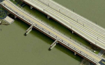 * Another feature that appears to be coming together for pedestrians and bicyclists is creating two overlooks that jut out above the river on the south side of the local bridge--these would use two of the in-water piers from the current downriver bridge, and you can see them at left and on slide 11.
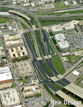 * To go across the river from Near Southeast on the freeway bridge, for access to DC-295 northbound and I-295 southbound, drivers will have a new ramp on the southeast corner of 11th and M (slide 4). The existing ramp at 8th and Virginia will still be available, too.
A few parts of the new design on the Near Southeast side of the project are worth (re-)pointing out, if you can make it through my torrent of descriptions:
* The "freeway" traffic and the "local" traffic will now be separated, with four lanes inbound and four lanes outbound on the freeway/upriver bridge and two lanes inbound/outbound on the "local"/downriver bridge (which Johnston was referring to as "Local 11th Street" because 11th will now feel like a street that crosses a river), as shown on slide 10.
* The local bridge will allow easier access between Near Southeast and Anacostia, for not only cars but pedestrians and bicycles, as well as streetcars when the routes are expanded. As part of this, 11th Street south of M is going to become two-way, and there will be bike lanes in both directions on 11th north of the bridge. (Slide 9)
* Another feature that appears to be coming together for pedestrians and bicyclists is creating two overlooks that jut out above the river on the south side of the local bridge--these would use two of the in-water piers from the current downriver bridge, and you can see them at left and on slide 11.* One of the big changes for traffic flow for both Near Southeast and Capitol Hill is that there is going to be a new two-lane on-ramp to go westward on the Southeast Freeway toward Virginia at 11th Street, underneath where the current flyover ramps are. (See slide 7.) Folks who have easier access to 11th Street will no longer have to drive along Virginia Avenue and/or 3rd Street to go westbound on the freeway.
But part of this new 11th Street intersection is that traffic coming from Pennsylvania Avenue along the sunken road that currently feeds directly into the freeway will instead be brought up to street level at this new signalized 11th Street intersection and will then drive straight onto the new on-ramp. So there will be some consternation from drivers using this route. (This is also shown on slide 7.)
* To go across the river from Near Southeast on the freeway bridge, for access to DC-295 northbound and I-295 southbound, drivers will have a new ramp on the southeast corner of 11th and M (slide 4). The existing ramp at 8th and Virginia will still be available, too. * There will still be an exit ramp from the inbound freeway bridge to I Street, just as there is now (slide 4).
* If you look at slide 4 very closely (and/or click on the bird's-eye view at right) and follow the paths off of each bridge, you can see how the freeway bridges coming across the river will have an exit for M Street similar to the current exit, but it deposits drivers at M just west of 12th instead of using 12th itself. It also no longer has the neat little N Street cut-through directly from the ramp that some Navy Yard workers cherish. To get to the Navy Yard, drivers will turn left on M, then left at 11th, and then go to whichever gate they need.
Other information in the slides includes: a graphic showing of the new ramps and accesses on the east side of the bridges at 295 and MLK (slide 12), of which the biggest addition is that you'll now be able to get to and from 295 and the bridges in all directions. There's also recent construction photos (including the first structural steel being laid on the freeway bridge), and information on stormwater management areas, and upcoming traffic impacts (slide 19).
It's expected that the freeway bridge will open about a year from now, with the new local bridge being finished in the winter of 2012/2013. (Dr. Gridlock wrote about recent milestones and upcoming work a few weeks ago.)
If you want to know more, there's my 11th Street Bridges project page, and you can also spend a couple months reading the Environmental Impact Statement to see all the studying they did of potential, um, impacts. There's also this Fact Sheet that they handed out.
|
Comments (0)
More posts:
11th Street Bridges, Traffic Issues
|