
|
| |||||||||||||||||||

|
Please note that JDLand is no longer being updated.
peek >>
Overview: South Capitol Street
The southern approach to the U.S. Capitol has begun its makeover, but more is still to come.
- Full Neighborhood Development MapThere's a lot more than just the projects listed here. See the complete map of completed, underway, and proposed projects all across the neighborhood.
- What's New This YearA quick look at what's arrived or been announced since the end of the 2018 baseball season.
- Food Options, Now and Coming SoonThere's now plenty of food options in the neighborhood. Click to see what's here, and what's coming.
![-]()
- Anacostia RiverwalkA bridge between Teague and Yards Parks is part of the planned 20-mile Anacostia Riverwalk multi-use trail along the east and west banks of the Anacostia River.
![-]()
- Virginia Ave. Tunnel ExpansionConstruction underway in 2015 to expand the 106-year-old tunnel to allow for a second track and double-height cars. Expected completion 2018.
![-]()
- Rail and Bus Times
Get real time data for the Navy Yard subway, Circulator, Bikeshare, and bus lines, plus additional transit information. - Rail and Bus Times
Get real time data for the Navy Yard subway, Circulator, Bikeshare, and bus lines, plus additional transit information. - Canal ParkThree-block park on the site of the old Washington Canal. Construction begun in spring 2011, opened Nov. 16, 2012.
![-]()
- Nationals Park21-acre site, 41,000-seat ballpark, construction begun May 2006, Opening Day March 30, 2008.
![-]()
- Washington Navy YardHeadquarters of the Naval District Washington, established in 1799.
![-]()
- Yards Park5.5-acre park on the banks of the Anacostia. First phase completed September 2010.
![-]()
- Van Ness Elementary SchoolDC Public School, closed in 2006, but reopening in stages beginning in 2015.
![-]()
- Agora/Whole Foods336-unit apartment building at 800 New Jersey Ave., SE. Construction begun June 2014, move-ins underway early 2018. Whole Foods expected to open in late 2018.
![-]()
- New Douglass BridgeConstruction underway in early 2018 on the replacement for the current South Capitol Street Bridge. Completion expected in 2021.
![-]()
- 1221 Van290-unit residential building with 26,000 sf retail. Underway late 2015, completed early 2018.

- NAB HQ/AvidianNew headquarters for National Association of Broadcasters, along with a 163-unit condo building. Construction underway early 2017.

- Yards/Parcel O Residential ProjectsThe Bower, a 138-unit condo building by PN Hoffman, and The Guild, a 190-unit rental building by Forest City on the southeast corner of 4th and Tingey. Underway fall 2016, delivery 2018.

- New DC Water HQA wrap-around six-story addition to the existing O Street Pumping Station. Construction underway in 2016, with completion in 2018.

- The Harlow/Square 769N AptsMixed-income rental building with 176 units, including 36 public housing units. Underway early 2017, delivery 2019.

- West Half Residential420-unit project with 65,000 sf retail. Construction underway spring 2017.
![-]()
- Novel South Capitol/2 I St.530ish-unit apartment building in two phases, on old McDonald's site. Construction underway early 2017, completed summer 2019.
![Novel South Capitol]()
- 1250 Half/Envy310 rental units at 1250, 123 condos at Envy, 60,000 square feet of retail. Underway spring 2017.
![-]()
- Parc Riverside Phase II314ish-unit residential building at 1010 Half St., SE, by Toll Bros. Construction underway summer 2017.
![-]()
- 99 M StreetA 224,000-square-foot office building by Skanska for the corner of 1st and M. Underway fall 2015, substantially complete summer 2018. Circa and an unnamed sibling restaurant announced tenants.
![-]()
- The Garrett375-unit rental building at 2nd and I with 13,000 sq ft retail. Construction underway late fall 2017.
![-]()
- Yards/The Estate Apts. and Thompson Hotel270-unit rental building and 227-room Thompson Hotel, with 20,000 sq ft retail total. Construction underway fall 2017.
![-]()
- Meridian on First275-unit residential building, by Paradigm. Construction underway early 2018.
![-]()
- The Maren/71 Potomac264-unit residential building with 12,500 sq ft retail, underway spring 2018. Phase 2 of RiverFront on the Anacostia development.
![-]()
- DC Crossing/Square 696Block bought in 2016 by Tishman Speyer, with plans for 800 apartment units and 44,000 square feet of retail in two phases. Digging underway April 2018.
![DC Crossing]()
- One Hill South Phase 2300ish-unit unnamed sibling building at South Capitol and I. Work underway summer 2018.
![One Hill South Phase 2]()
- New DDOT HQ/250 MNew headquarters for the District Department of Transportation. Underway early 2019.
![New DDOT HQ]()
- 37 L Street Condos11-story, 74-unit condo building west of Half St. Underway early 2019.
![37 L Condos]()
- CSX East Residential/Hotel225ish-unit AC Marriott and two residential buildings planned. Digging underway late summer 2019.
![CSX East Residential/Hotel]()
- 1000 South Capitol Residential224-unit apartment building by Lerner. Underway fall 2019.
![1000 South Capitol Residential]()
- Capper Seniors 2.0Reconstruction of the 160-unit building for low-income seniors that was destroyed by fire in 2018.
![1000 South Capitol Residential]()
- Chemonics HQNew 285,000-sq-ft office building with 14,000 sq ft of retail. Expected delivery 2021.
![1000 South Capitol Residential]()


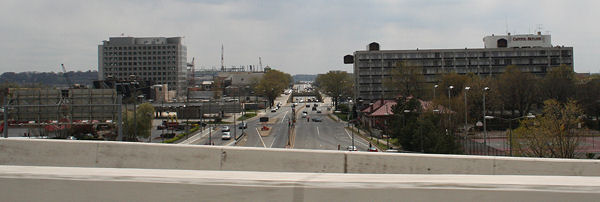
An overview of the Near Southeast portion of South Capitol Street, looking north from south of O Street, in January 2006. (01/06)
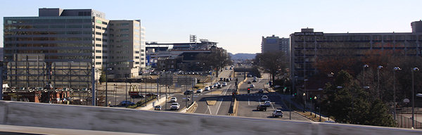
The same location (honest!), in November 2012, after the July 2007 demolition of the northern end of the South Capitol Street/Frederick Douglass Bridge, bringing South Capitol Street down to grade level from Potomac Avenue north. Nationals Park lines the eastern side of South Capitol Street from Potomac Avenue to N Street, and the Camden South Capitol apartment building is at left. This six-lane-with-median-and-wide-sidewalks motif will be continued northward eventually. 

 A basic overview of the plans to revamp the portion of South Capitol Street west of the Anacostia River, as laid out in the South Capitol Street Environmental Impact Statement.
Starting at the top, at South Capitol's intersection with the SE Freeway, the existing ramp that begins at I Street will be replaced with an at-grade intersection underneath the freeway that would have two left-turn lanes to a new ramp (which is seen here at the very top, shaded pale yellow). With the removal of the existing ramp to I-395, the intersection and South Capitol and I would also be reconfigured.
Between I and L streets, a median would be installed, as would wider sidewalks and other improvements.
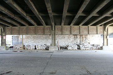
The existing overpass/underpass interchange with M Street would become an at-grade configuration, seen here with what appear to be multiple left-turn lanes to help traffic flow.
The sections from N to P would see some additional upgrading, but the bulk of the work on these blocks was completed in 2007.
South of P would begin the approach to a new large traffic oval that would regulate the traffic flow along South Capitol, Potomac, Q, and the new Douglass Bridge, seen here in its new alignment to the southwest of the current bridge's footprint. The oval's interior is expected to be configured as a large greenspace/park area.
See my separate Douglass Bridge page for details on the plans and designs for this new South Capitol Street bridge between Near Southeast and Anacostia. And also See the EIS for the additional plans east of the river, including a new traffic circle at Howard Avenue and a revamped interchange with I-295.
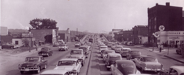
A photo from the District Department of Transportation's archives shows South Capitol Street, looking south from just past N Street, circa 1957. The approach to the Douglass Bridge is visible in the next block. At the far end of the street, on the right, is a Lansburgh's department store. (1957)
The same location, in October 2005. The cafeteria at left in 1957 is seen here as the "Heat" gay nightclub. The Lansburgh building became a U-Haul storage facility in 2002. (10/05)
And once more, 2 1/2 years later, after the raised viaduct of the Douglass Bridge was demolished, and as Nationals Park prepares to open. (8/3/08)

Looking at the remade South Capitol Street north of N, from the ballpark's viewing platform, 10 months after the street was revamped in the wake of the viaduct demolition. The underpass/overpass intersection seen to the north (at M Street) is expected to be removed and replaced with an at-grade intersection as part of the plans to revamp much of South Capitol, and the six-lane-with-median motif will be extended northward to the SE Freeway. (5/26/08)
This was the view for many years looking north from Potomac Avenue on South Capitol Street. (10/05)
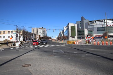
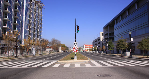
January 12, 2020 - The same spot, with the viaduct demolished, and the Nationals ballpark at the right. This view will change substantially when a new traffic oval is built on this location to handle the approach to and from the relocated South Capitol Street Bridge
This is what you saw if you stood in the "center" of South Capitol Street at P Street, looking north, until July 2007. (06/07)
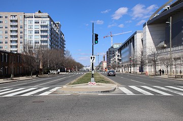
March 17, 2019 - The same location (honest!), after the demolition of the viaduct and 154 months after work began on the baseball stadium. Look at the private homes on the left, and imagine how different their view is now that the viaduct is gone.
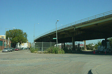
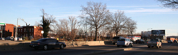
Once you get north of the stadium site, change hasn't quite yet come to South Capitol Street. This is the view from N Street--maybe someday the underpass intersection one block north at M Street will be replaced, but not just yet. (10/13)

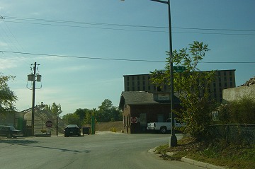
The importance of the South Capitol-and-M intersection is not obvious by the buildings currently surrounding it. On the northwest side, a 7-11 and some fast-food options are the main offerings. (02/07)
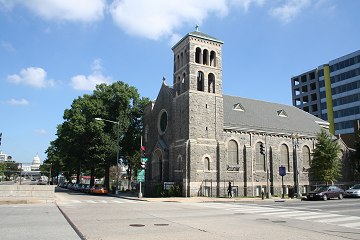
The northeast corner of South Capitol and M streets, with St. Vincent de Paul as the main focal point, 20 M looming behind, and some big building with a white dome on it visible to the north. (09/06)
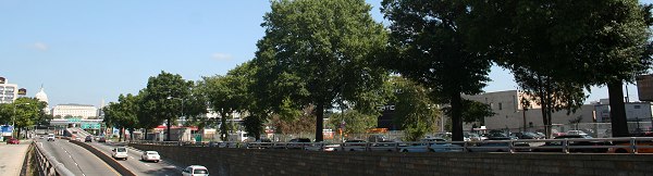
The eastern side of South Capitol Street, north of M. At far right is the lot that may eventually be 1100 South Capitol, a 330,000-sq-ft office building being developed by Lawrence Ruben Co.; toward the center, between K and L, is the lot owned by Lerner Enterprises being proposed as 1000 South Capitol, a 320,000-sq-ft office building. North of K is the now-closed Exxon station. In the plans for revamping South Capitol, this underpass will be removed when the M Street intersection is changed to at-grade. There will then be six lanes, and a median. (09/06)
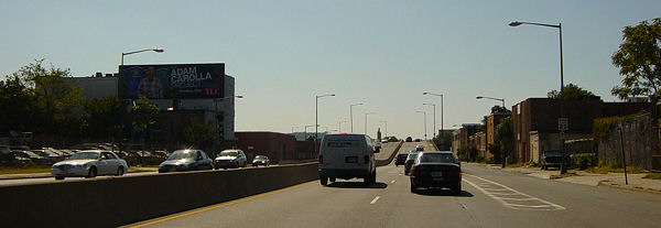
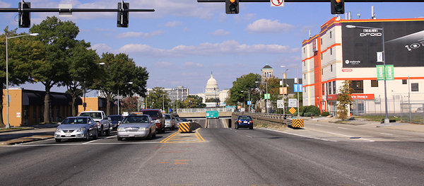
By the time you get far enough north on South Capitol to be close to the US Capitol, the lovely SE Freeway obscures the view completely. This will change when South Capitol's interchange with the SE Freeway is revamped, replacing the existing ramp seen here with an at-grade intersection underneath the freeway that would have two left-turn lanes to a new ramp. With the removal of the existing ramp to I-395, the intersection and South Capitol and I would also be reconfigured. (02/04)
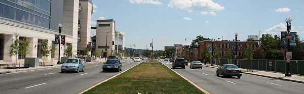
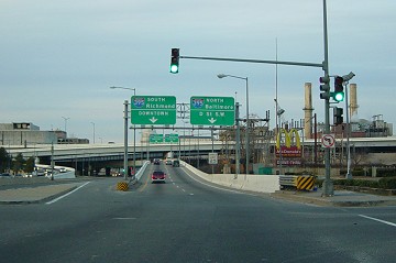
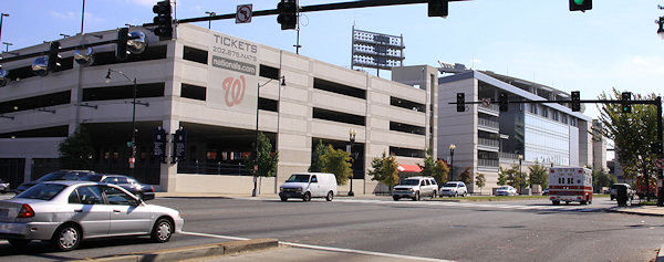
Turning back around and looking south down South Capitol Street, as seen from the SE Freeway in April 2007. If you know what you're looking for, you can see the stadium at left center. 20 M Street is the completed building at left. (04/07)
January 18, 2014 - The same location.
Another view to the south down South Capitol, this time showing the northwest side of the stadium footprint, from just north of N Street, in February 2006. The five residential properties within the entire 21-acre stadium footprint are at far left. (02/06)
The same location, in October 2013, dominated by the ballpark and its parking garage. (10/13)
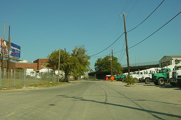
There is actually a portion of South Capitol Street that runs south of Potomac Avenue down to S Street (though there's no longer any direct intersection of this stub street with Potomac). This photo, from October 2005, looks north on South Capitol at R Street/Water Street. This location will eventually be the southern tip of the new traffic oval, with the new Douglass Bridge traffic arriving at the oval just to the right of this location. (10/05)
The southernmost part of South Capitol Street on the west side of the Anacostia River, looking south at its intersection with S Street in Buzzard Point. This final block of South Capitol from R to S would be closed down as part of the new bridge-and-oval configuration. (10/05)
Latest News
November 3, 2019
The New Douglass Bridge: A Look Ahead to the West Traffic Oval
July 19, 2019
Tidbits: Lazy Hazy Heat-Emergency Days of Summer
May 20, 2019
Catching Up with the New Douglass Bridge
February 4, 2019
Quick Tidbit Roundup
September 21, 2018
ANC 6D07 Candidates Forum, Douglass Bridge Meetings
March 30, 2016
New Douglass Bridge Update: Final RFP Issued
September 9, 2015
Across the Way: Possible Residential on South Capitol St. SW
August 31, 2015
New Douglass Bridge Gets Federal OK, $587M Funding from DC
March 24, 2015
Tuesday Tidbits: Slow Down, You Move Too Fast
January 27, 2015
Tuesday Tidbits: Homewood Permit, Fitness Fair, and More