
|
| |||||||||||||||||||

|
Please note that JDLand is no longer being updated.
peek >>
Near Southeast DC Past News Items: Dec 29, 2009
- Full Neighborhood Development MapThere's a lot more than just the projects listed here. See the complete map of completed, underway, and proposed projects all across the neighborhood.
- What's New This YearA quick look at what's arrived or been announced since the end of the 2018 baseball season.
- Food Options, Now and Coming SoonThere's now plenty of food options in the neighborhood. Click to see what's here, and what's coming.
![-]()
- Anacostia RiverwalkA bridge between Teague and Yards Parks is part of the planned 20-mile Anacostia Riverwalk multi-use trail along the east and west banks of the Anacostia River.
![-]()
- Virginia Ave. Tunnel ExpansionConstruction underway in 2015 to expand the 106-year-old tunnel to allow for a second track and double-height cars. Expected completion 2018.
![-]()
- Rail and Bus Times
Get real time data for the Navy Yard subway, Circulator, Bikeshare, and bus lines, plus additional transit information. - Rail and Bus Times
Get real time data for the Navy Yard subway, Circulator, Bikeshare, and bus lines, plus additional transit information. - Canal ParkThree-block park on the site of the old Washington Canal. Construction begun in spring 2011, opened Nov. 16, 2012.
![-]()
- Nationals Park21-acre site, 41,000-seat ballpark, construction begun May 2006, Opening Day March 30, 2008.
![-]()
- Washington Navy YardHeadquarters of the Naval District Washington, established in 1799.
![-]()
- Yards Park5.5-acre park on the banks of the Anacostia. First phase completed September 2010.
![-]()
- Van Ness Elementary SchoolDC Public School, closed in 2006, but reopening in stages beginning in 2015.
![-]()
- Agora/Whole Foods336-unit apartment building at 800 New Jersey Ave., SE. Construction begun June 2014, move-ins underway early 2018. Whole Foods expected to open in late 2018.
![-]()
- New Douglass BridgeConstruction underway in early 2018 on the replacement for the current South Capitol Street Bridge. Completion expected in 2021.
![-]()
- 1221 Van290-unit residential building with 26,000 sf retail. Underway late 2015, completed early 2018.

- NAB HQ/AvidianNew headquarters for National Association of Broadcasters, along with a 163-unit condo building. Construction underway early 2017.

- Yards/Parcel O Residential ProjectsThe Bower, a 138-unit condo building by PN Hoffman, and The Guild, a 190-unit rental building by Forest City on the southeast corner of 4th and Tingey. Underway fall 2016, delivery 2018.

- New DC Water HQA wrap-around six-story addition to the existing O Street Pumping Station. Construction underway in 2016, with completion in 2018.

- The Harlow/Square 769N AptsMixed-income rental building with 176 units, including 36 public housing units. Underway early 2017, delivery 2019.

- West Half Residential420-unit project with 65,000 sf retail. Construction underway spring 2017.
![-]()
- Novel South Capitol/2 I St.530ish-unit apartment building in two phases, on old McDonald's site. Construction underway early 2017, completed summer 2019.
![Novel South Capitol]()
- 1250 Half/Envy310 rental units at 1250, 123 condos at Envy, 60,000 square feet of retail. Underway spring 2017.
![-]()
- Parc Riverside Phase II314ish-unit residential building at 1010 Half St., SE, by Toll Bros. Construction underway summer 2017.
![-]()
- 99 M StreetA 224,000-square-foot office building by Skanska for the corner of 1st and M. Underway fall 2015, substantially complete summer 2018. Circa and an unnamed sibling restaurant announced tenants.
![-]()
- The Garrett375-unit rental building at 2nd and I with 13,000 sq ft retail. Construction underway late fall 2017.
![-]()
- Yards/The Estate Apts. and Thompson Hotel270-unit rental building and 227-room Thompson Hotel, with 20,000 sq ft retail total. Construction underway fall 2017.
![-]()
- Meridian on First275-unit residential building, by Paradigm. Construction underway early 2018.
![-]()
- The Maren/71 Potomac264-unit residential building with 12,500 sq ft retail, underway spring 2018. Phase 2 of RiverFront on the Anacostia development.
![-]()
- DC Crossing/Square 696Block bought in 2016 by Tishman Speyer, with plans for 800 apartment units and 44,000 square feet of retail in two phases. Digging underway April 2018.
![DC Crossing]()
- One Hill South Phase 2300ish-unit unnamed sibling building at South Capitol and I. Work underway summer 2018.
![One Hill South Phase 2]()
- New DDOT HQ/250 MNew headquarters for the District Department of Transportation. Underway early 2019.
![New DDOT HQ]()
- 37 L Street Condos11-story, 74-unit condo building west of Half St. Underway early 2019.
![37 L Condos]()
- CSX East Residential/Hotel225ish-unit AC Marriott and two residential buildings planned. Digging underway late summer 2019.
![CSX East Residential/Hotel]()
- 1000 South Capitol Residential224-unit apartment building by Lerner. Underway fall 2019.
![1000 South Capitol Residential]()
- Capper Seniors 2.0Reconstruction of the 160-unit building for low-income seniors that was destroyed by fire in 2018.
![1000 South Capitol Residential]()
- Chemonics HQNew 285,000-sq-ft office building with 14,000 sq ft of retail. Expected delivery 2021.
![1000 South Capitol Residential]()


1 Blog Posts
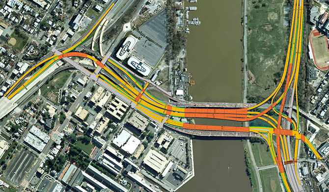 On a chilly morning (with winds high enough to scuttle the planned boat tour), DDOT announced that work is officially underway on the new 11th Street Bridges, the $300 million four-year project to build three new spans across the Anacostia River to provide both expanded freeway access between I-295 and the SE/SW Freeway and a new local-traffic bridge connecting Anacostia and Near Southeast.
Pile driving in the river is expected to start within the next day or two (it was supposed to start today, but the winds scuttled that, too). Engineers said it should be at least 18 months before there are any changes to the traffic flow on either side of the river.
The biggest changes in the configuration of the bridges will be the new ramps allowing for access from southbound I-295 to the bridges and from the bridges to northbound DC295, meaning that much of the neighborhood cut-through traffic and bad flow on Pennsylvania Avenue should be mitigated, though residents who oppose the expansion of the bridges' capacity--such as the Capitol Hill Restoration Society--differ with DDOT on the benefits of the project.
The third span--a "local street that happens to cross a river," in the words of DDOT's Bart Clark--will be built with streetcar tracks included in the two curb lanes, and will also include wide pedestrian/cycling paths, bulb-out bridge overlooks (where you can stop and look at the view without impeding the flow), and even osprey nest perches down by the water. This span, allowing local traffic to cross the river without having to mix with high-speed freeway traffic as it currently does, will reach street level at O Street on the west side of the river, which will also make for an easy connection to the Anacostia Riverwalk Trail. And all new bridges will be built with shoulders, to help lessen backups when there are accidents.
One additional change in all of this is that the Anacostia Community Boathouse operations, which are currently nestled between the existing spans, will be permanently moved northeast, to the Anacostia marina, and the old red brick buildings will be demolished. (A temporary structure is being built to get their operations moved by spring.)
For the next few months, pile driving and some off-roadway clearing and minor lane shifts on DC-295 will be the extent of the construction, but by late spring or early summer there will begin to be work underway on both O Street and M Street
I've added new graphics to my 11th Street Bridges page that show the plans for the new bridges. It will be an interesting project to watch over the next few years.
In addition, demolition work on the existing ramps to and from RFK has perked back up again, and there will be lane closures on the portion of the freeway that connects to Pennsylvania Avenue within the next few weeks. (If you saw the variable message sign at the Sixth Street SE exit that said "Freeway to be closed on or about 1/9/2010," it was a bit of a verbiage boo-boo that was meant to alert drivers to the coming lane closures, and is being fixed.)
There was a decent amount of press at the briefing (both Dr. Gridlock and Bob Marbourg were in the house, so you know it was serious), and I'll be updating this entry as stories come online, most of which will no doubt give more focus to the changes coming to the east side of the river than I have here (though I have posted some enlarged graphics that show both sides of the river). Here's the DDOT press release, fact sheet, and FAQ.
UPDATE: Links to Dr. Gridlock, WTOP, and City Paper. And WUSA. (I won't bother with pieces written right off the press release.)
UPDATE II: A bike-centric look at the plans from WashCycle.
|
Comments (0)
More posts:
11th Street Bridges, Boathouse Row
|