
|
| |||||||||||||||||||

|
Please note that JDLand is no longer being updated.
peek >>
Near Southeast DC Past News Items: Mar 24, 2011
- Full Neighborhood Development MapThere's a lot more than just the projects listed here. See the complete map of completed, underway, and proposed projects all across the neighborhood.
- What's New This YearA quick look at what's arrived or been announced since the end of the 2018 baseball season.
- Food Options, Now and Coming SoonThere's now plenty of food options in the neighborhood. Click to see what's here, and what's coming.
![-]()
- Anacostia RiverwalkA bridge between Teague and Yards Parks is part of the planned 20-mile Anacostia Riverwalk multi-use trail along the east and west banks of the Anacostia River.
![-]()
- Virginia Ave. Tunnel ExpansionConstruction underway in 2015 to expand the 106-year-old tunnel to allow for a second track and double-height cars. Expected completion 2018.
![-]()
- Rail and Bus Times
Get real time data for the Navy Yard subway, Circulator, Bikeshare, and bus lines, plus additional transit information. - Rail and Bus Times
Get real time data for the Navy Yard subway, Circulator, Bikeshare, and bus lines, plus additional transit information. - Canal ParkThree-block park on the site of the old Washington Canal. Construction begun in spring 2011, opened Nov. 16, 2012.
![-]()
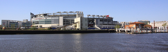
- Nationals Park21-acre site, 41,000-seat ballpark, construction begun May 2006, Opening Day March 30, 2008.
![-]()
- Washington Navy YardHeadquarters of the Naval District Washington, established in 1799.
![-]()
- Yards Park5.5-acre park on the banks of the Anacostia. First phase completed September 2010.
![-]()
- Van Ness Elementary SchoolDC Public School, closed in 2006, but reopening in stages beginning in 2015.
![-]()
- Agora/Whole Foods336-unit apartment building at 800 New Jersey Ave., SE. Construction begun June 2014, move-ins underway early 2018. Whole Foods expected to open in late 2018.
![-]()
- New Douglass BridgeConstruction underway in early 2018 on the replacement for the current South Capitol Street Bridge. Completion expected in 2021.
![-]()
- 1221 Van290-unit residential building with 26,000 sf retail. Underway late 2015, completed early 2018.

- NAB HQ/AvidianNew headquarters for National Association of Broadcasters, along with a 163-unit condo building. Construction underway early 2017.

- Yards/Parcel O Residential ProjectsThe Bower, a 138-unit condo building by PN Hoffman, and The Guild, a 190-unit rental building by Forest City on the southeast corner of 4th and Tingey. Underway fall 2016, delivery 2018.

- New DC Water HQA wrap-around six-story addition to the existing O Street Pumping Station. Construction underway in 2016, with completion in 2018.

- The Harlow/Square 769N AptsMixed-income rental building with 176 units, including 36 public housing units. Underway early 2017, delivery 2019.

- West Half Residential420-unit project with 65,000 sf retail. Construction underway spring 2017.
![-]()
- Novel South Capitol/2 I St.530ish-unit apartment building in two phases, on old McDonald's site. Construction underway early 2017, completed summer 2019.
![Novel South Capitol]()
- 1250 Half/Envy310 rental units at 1250, 123 condos at Envy, 60,000 square feet of retail. Underway spring 2017.
![-]()
- Parc Riverside Phase II314ish-unit residential building at 1010 Half St., SE, by Toll Bros. Construction underway summer 2017.
![-]()
- 99 M StreetA 224,000-square-foot office building by Skanska for the corner of 1st and M. Underway fall 2015, substantially complete summer 2018. Circa and an unnamed sibling restaurant announced tenants.
![-]()
- The Garrett375-unit rental building at 2nd and I with 13,000 sq ft retail. Construction underway late fall 2017.
![-]()
- Yards/The Estate Apts. and Thompson Hotel270-unit rental building and 227-room Thompson Hotel, with 20,000 sq ft retail total. Construction underway fall 2017.
![-]()
- Meridian on First275-unit residential building, by Paradigm. Construction underway early 2018.
![-]()
- The Maren/71 Potomac264-unit residential building with 12,500 sq ft retail, underway spring 2018. Phase 2 of RiverFront on the Anacostia development.
![-]()
- DC Crossing/Square 696Block bought in 2016 by Tishman Speyer, with plans for 800 apartment units and 44,000 square feet of retail in two phases. Digging underway April 2018.
![DC Crossing]()
- One Hill South Phase 2300ish-unit unnamed sibling building at South Capitol and I. Work underway summer 2018.
![One Hill South Phase 2]()
- New DDOT HQ/250 MNew headquarters for the District Department of Transportation. Underway early 2019.
![New DDOT HQ]()
- 37 L Street Condos11-story, 74-unit condo building west of Half St. Underway early 2019.
![37 L Condos]()
- CSX East Residential/Hotel225ish-unit AC Marriott and two residential buildings planned. Digging underway late summer 2019.
![CSX East Residential/Hotel]()
- 1000 South Capitol Residential224-unit apartment building by Lerner. Underway fall 2019.
![1000 South Capitol Residential]()
- Capper Seniors 2.0Reconstruction of the 160-unit building for low-income seniors that was destroyed by fire in 2018.
![1000 South Capitol Residential]()
- Chemonics HQNew 285,000-sq-ft office building with 14,000 sq ft of retail. Expected delivery 2021.
![1000 South Capitol Residential]()


3 Blog Posts
Numbers geeks rejoiced on Thursday when the 2010 census numbers for DC were released, and of course I had to dig right in.
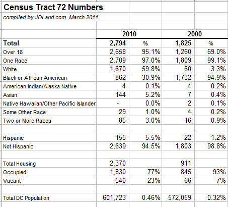
The population of Census Tract 72 in 2010 is given as 2,794, an increase of nearly 1,000 residents from 2000 and which accounts for about 11 percent of the entire Ward 6 population increase. The demographic numbers are striking: Near Southeast is now nearly 60 percent white and 31 percent African American, compared to being nearly 95 percent black 10 years ago. It's also interesting that it found 95 percent of the population to be age 18 or older, compared to only 69 percent in 2000. There's also 1,459 more housing units counted in the neighborhood (and that number has certainly gone up since the census was taken).
Here are the numbers:
(You can see an expanded list with percentage change and some additional numbers here, which also shows that the neighborhood's population counted at 2,089 residents in 1990 and 2,994 in 1980.)
The Capitol Riverfront BID has estimated that the neighborhood population was around 3,300 at the end of 2010.
Even though the population of DC itself climbed by nearly 30,000 in the last 10 years, Near Southeast is now a larger portion of the overall population than it was 10 years ago, skyrocketing to a whopping .46 percent of the city's count.
"Tract 72" covers the area south of the freeway from South Capitol Street to 11th Street, but unless people are living east of 11th on their boats (or in a van down by the river), the boundaries would cover all of the residential areas of Near Southeast.
Of course, what future researchers looking at census numbers will never see is how much more the neighborhood emptied out through 2005 (when only 410 M and the private single-family homes were occupied). My guess would be that the population got down to around 400 during that time, if not lower.
Income-related demographic numbers for 2010 aren't yet released, but it's not hard to assume that those numbers will show an equally dramatic change.
And now that the city's numbers are out, the fun really begins with the need to redraw the ward boundaries, which will then beget a redrawing of the ANC boundaries. ANCs are supposed to have about 2,000 residents per single member district--will Near Southeast cease being covered by a single SMD? Or, for that matter, will all of Near Southeast remain in Ward 6, given the noises Marion Barry is making about the necessary redrawing of Ward 8's boundaries? "I'll defend the riverfront," is the quote from Field Marshall Thomas von Wells. (Hey, we kid because we love.) "Ward 6 should remain the same."
(Note: I wrote a slightly different summary of Near Southeast's census numbers for the Post; the numbers cited in that article use the Post's internal numbers by neighborhood instead of going purely by Tract 72. Not sure exactly where the different boundaries are, but I'll stay with Tract 72 here since it's easier to get access to those numbers publicly for checking and comparison.)
|
Comments (4)
|
Michael Perkins at GGW got his hands on the draft version DDOT's 2010 Ballpark District Performance Parking Report, and while I'll leave it to him to handle the in-depth discussion of pricing and meter use in Near Southeast as well as other neighborhoods, there are a few action items in the report that might be of general interest (you should read all 31 pages if you want the nitty-gritty).
Now, this is a draft report, but assuming it becomes final...:
Revenues from the parking program have been able to provide $812,100 for "non-automotive transportation improvements" in 2011, which will include a new Capital Bikeshare location at the Yards Park and $135,000 for a new fence along New Jersey Avenue by the railroad tracks (presumably it won't hide the "Water Pylons" public art coming to the freeway underpass). There will also be two or three other new bikeshare stations somewhere in the Ballpark District parking zones (Near Southeast, Southwest, and southern Capitol Hill), but those haven't been announced.
There will also be a $70,000 grant to partially fund a Capitol Riverfront BID Transportation Study, which the page 25 of the report says will happen during this fiscal year and will look at:
* The need for additional traffic signals and stop signs based on pedestrian and vehicular patterns (and recent accidents);
* Neighborhood traffic circulation patterns including one way street circulation and freeway access and turning movements onto the freeway frontage roads;
* How the CSX tunnel reconstruction will impact traffic flow and SE/SW freeway access/egress;
* Existing and future parking demand and the proposed parking supply to meet that demand;
* On street parking strategies and supply for commercial, residential and visitor populations;
* Optimum Circulator routes and hours of operation;
* Recommended routes for bike lanes that tie into the Riverfront Trail system;
* The optimum route for a streetcar line in the M Street right of way and how it would service the Buzzard Point subdistrict; and
* How M Street is designed and works as a multi-modal transit corridor while exhibiting a high quality of design in the public realm.
Gosh, I'm just not sure if residents will be interested in any of these! If perchance a reader or two might have an idea or data point for the above items, feel free to discuss in the comments.
Note that this study doesn't quite seem to match the overarching Near Southeast/Southwest combined traffic study that got some discussion late last year, but perhaps there's more going on than what's mentioned in the DDOT report.
DDOT is also proposing that non-gameday parking rates at the multispace meters between South Capitol and 2nd Streets from the freeway to M Street go up to $6 for three hours (first hour $1.50, second hour $2.50, third hour $3). Plus, the boundaries of the parking zone will move eastward to 11th St. SE from 9th St.
By the way, if you have a fab idea for how some of the proceeds from the parking revenue can be spent on the aforementioned non-automotive transportation improvements, you can submit a written proposal to DDOT (further information on page 26 of the report). And if you want background on how the Performance Parking Pilot came into existence back in 2008, my Stadium Parking page can help with that.
|
Comments (2)
|
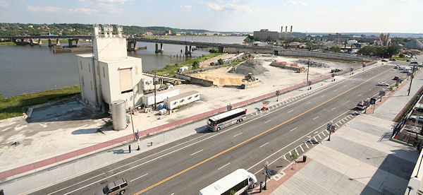 I've gotten a bit more information about the raze permit application at the Florida Rock site, the concrete plant on the banks of the Anacostia directly across from Nationals Park.
 According to Florida Rock Properties, the owner of the site, the tenants are building a new plant on land also owned by FRP down South Capitol Street on Buzzard Point (at S and Water streets near the Pepco plant and the Coast Guard building). Once that new site is completed, the existing operations on Potomac Avenue will be shut down and the structures will be razed, which should happen sometime this summer (though timelines on these sorts of projects are never written in concrete, ha ha).
The plant is one of the last specimens of the ballpark area's previous life as an industrial zone, and has housed a gravel/stone/concrete operation since the 1920s, when Smoot Sand and Gravel operated there after moving from what is now the Yards Park site when the Navy Yard expanded its boundaries during World War I. I have taken scads of photos that have included it over the years, and should probably thank my lucky stars that I was never mowed down by any of the trucks coming in and out of there during all my photographing of the ballpark's construction. There was certainly a close call or two.
As I've noted about a billion times over the past eight years, the site's redevelopment plans call for a 1.1-million-sq-ft mixed-use four-phase development, but Florida Rock Properties does not as yet have any deals in place to get this new "RiverFront" project started. In 2009 they received a time extension on their zoning PUD, and are not required to file building permits until June 2012. The site will probably remain fenced and unused in the interim, but at least the dismantling of the tower will finally allow unobstructed views of the Anacostia River, the Douglass Bridge, and the east bank of the river from the ballpark's southeastern viewing platform. Not to mention nicer views of the ballpark from the river, for boats such as those using the Diamond Teague Piers next door. At least until the new development goes up....
|
Comments (1)
More posts:
Development News, Florida Rock
|