
|
| |||||||||||||||||||

|
Please note that JDLand is no longer being updated.
peek >>
Near Southeast DC Past News Items: Feb 03, 2009
- Full Neighborhood Development MapThere's a lot more than just the projects listed here. See the complete map of completed, underway, and proposed projects all across the neighborhood.
- What's New This YearA quick look at what's arrived or been announced since the end of the 2018 baseball season.
- Food Options, Now and Coming SoonThere's now plenty of food options in the neighborhood. Click to see what's here, and what's coming.
![-]()
- Anacostia RiverwalkA bridge between Teague and Yards Parks is part of the planned 20-mile Anacostia Riverwalk multi-use trail along the east and west banks of the Anacostia River.
![-]()
- Virginia Ave. Tunnel ExpansionConstruction underway in 2015 to expand the 106-year-old tunnel to allow for a second track and double-height cars. Expected completion 2018.
![-]()
- Rail and Bus Times
Get real time data for the Navy Yard subway, Circulator, Bikeshare, and bus lines, plus additional transit information. - Rail and Bus Times
Get real time data for the Navy Yard subway, Circulator, Bikeshare, and bus lines, plus additional transit information. - Canal ParkThree-block park on the site of the old Washington Canal. Construction begun in spring 2011, opened Nov. 16, 2012.
![-]()
- Nationals Park21-acre site, 41,000-seat ballpark, construction begun May 2006, Opening Day March 30, 2008.
![-]()
- Washington Navy YardHeadquarters of the Naval District Washington, established in 1799.
![-]()
- Yards Park5.5-acre park on the banks of the Anacostia. First phase completed September 2010.
![-]()
- Van Ness Elementary SchoolDC Public School, closed in 2006, but reopening in stages beginning in 2015.
![-]()
- Agora/Whole Foods336-unit apartment building at 800 New Jersey Ave., SE. Construction begun June 2014, move-ins underway early 2018. Whole Foods expected to open in late 2018.
![-]()
- New Douglass BridgeConstruction underway in early 2018 on the replacement for the current South Capitol Street Bridge. Completion expected in 2021.
![-]()
- 1221 Van290-unit residential building with 26,000 sf retail. Underway late 2015, completed early 2018.

- NAB HQ/AvidianNew headquarters for National Association of Broadcasters, along with a 163-unit condo building. Construction underway early 2017.

- Yards/Parcel O Residential ProjectsThe Bower, a 138-unit condo building by PN Hoffman, and The Guild, a 190-unit rental building by Forest City on the southeast corner of 4th and Tingey. Underway fall 2016, delivery 2018.

- New DC Water HQA wrap-around six-story addition to the existing O Street Pumping Station. Construction underway in 2016, with completion in 2018.

- The Harlow/Square 769N AptsMixed-income rental building with 176 units, including 36 public housing units. Underway early 2017, delivery 2019.

- West Half Residential420-unit project with 65,000 sf retail. Construction underway spring 2017.
![-]()
- Novel South Capitol/2 I St.530ish-unit apartment building in two phases, on old McDonald's site. Construction underway early 2017, completed summer 2019.
![Novel South Capitol]()
- 1250 Half/Envy310 rental units at 1250, 123 condos at Envy, 60,000 square feet of retail. Underway spring 2017.
![-]()
- Parc Riverside Phase II314ish-unit residential building at 1010 Half St., SE, by Toll Bros. Construction underway summer 2017.
![-]()
- 99 M StreetA 224,000-square-foot office building by Skanska for the corner of 1st and M. Underway fall 2015, substantially complete summer 2018. Circa and an unnamed sibling restaurant announced tenants.
![-]()
- The Garrett375-unit rental building at 2nd and I with 13,000 sq ft retail. Construction underway late fall 2017.
![-]()
- Yards/The Estate Apts. and Thompson Hotel270-unit rental building and 227-room Thompson Hotel, with 20,000 sq ft retail total. Construction underway fall 2017.
![-]()
- Meridian on First275-unit residential building, by Paradigm. Construction underway early 2018.
![-]()
- The Maren/71 Potomac264-unit residential building with 12,500 sq ft retail, underway spring 2018. Phase 2 of RiverFront on the Anacostia development.
![-]()
- DC Crossing/Square 696Block bought in 2016 by Tishman Speyer, with plans for 800 apartment units and 44,000 square feet of retail in two phases. Digging underway April 2018.
![DC Crossing]()
- One Hill South Phase 2300ish-unit unnamed sibling building at South Capitol and I. Work underway summer 2018.
![One Hill South Phase 2]()
- New DDOT HQ/250 MNew headquarters for the District Department of Transportation. Underway early 2019.
![New DDOT HQ]()
- 37 L Street Condos11-story, 74-unit condo building west of Half St. Underway early 2019.
![37 L Condos]()
- CSX East Residential/Hotel225ish-unit AC Marriott and two residential buildings planned. Digging underway late summer 2019.
![CSX East Residential/Hotel]()
- 1000 South Capitol Residential224-unit apartment building by Lerner. Underway fall 2019.
![1000 South Capitol Residential]()
- Capper Seniors 2.0Reconstruction of the 160-unit building for low-income seniors that was destroyed by fire in 2018.
![1000 South Capitol Residential]()
- Chemonics HQNew 285,000-sq-ft office building with 14,000 sq ft of retail. Expected delivery 2021.
![1000 South Capitol Residential]()


2 Blog Posts
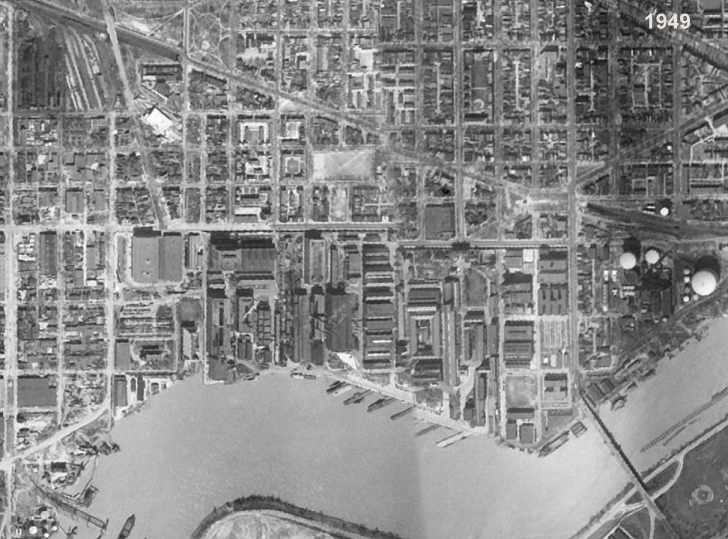 With great thanks to reader G. for passing this along, I can report that the newly released Google Earth 5.0 (beta, of course) now includes an option to page back through older satellite photos. As you might imagine, I raced to see what they had for Near Southeast, and found a not-razor-sharp 1949 image, which you can see on my Near Southeast Satellite Photos page if you don't have Google Earth.
You might enjoy the "Where's Waldo?" test of looking for buildings you recognize, such as the Southeastern Bus Garage, the WASA buildings, and even that big brick warehouse at South Capitol and O that was demolished to make way for the ballpark. Things that *aren't* there: the Southeast Freeway (built in the 1960s), the second span of the 11th Street Bridges, a completed Douglass Bridge, and many of the Capper buildings that came in the 1950s. You'll also see how packed with buildings the Navy Yard was, especially since this was still during the time that its boundaries stretched all the way to First Street (across what is now The Yards). And look at how, north of Virginia Avenue, Garfield Park was bisected by Second Street.
The other image offerings from Near Southeast are mostly variants on the ones I already have on my satellite photos page that came from non-Google sources over the years (1988, 2002, 2004, 2006, 2007), though there are a few extras from the later years where the quality of the image isn't all that good.
If this is whetting your appetite, I also have a batch of non-satellite historic photos of the neighborhood you can wander through, along with detailed street maps from 1903 through 1921.
UPDATE: Commenter MJM rightly reminds me of a fact that an American History major such as myself should have remembered: Sputnik was the first *satellite*, launched in 1957. So these overhead images from 1949 are not satellite images, but were taken from planes. Or they attached a camera to Superman and had him fly around the globe a few times.
|
Comments (0)
|
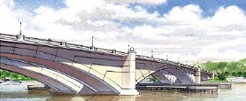
ANC 6D heard a presentation on Monday night from the team working on the South Capitol Street Environmental Impact Statement, which is now in its "final preferred alternative" stage. Their PowerPoint presentation was pretty close to the one I posted last month, and one of the consultants did tweak me a bit about how I "spoiled the surprise" on the choice of the arched bascule design for the new Douglass Bridge.
Here again are the (long!) bullet points about what the preferred alternative designs are for the portion of South Capitol west of the Anacostia (see the presentation if you're interested in the preferred alternatives chosen for east of the river), along with some issues raised by the ANC:
* It was emphasized that these new designs will not be adding any capacity, but that the main goal is to bring back the "boulevard" feeling of the corridor.
* The new bridge will have 20-foot-wide sidewalks on each side, and only two piers will need to be built in the river, compared to 3-5 piers that would have been needed with the other designs. (The cable stayed swing bridge would have had just one pedestrian/bike path, 16 feet wide, in the middle of the bridge, surrounded by six lanes of traffic.)
 * There will be a seven-acre traffic oval at the foot of the new bridge (which will be located to the south of the current bridge), reshaping the intersection of South Capitol Street and Potomac Avenue. (The ballpark's Home Plate Gate and entrance promenade will be the northeast edge of the oval.) The city is already in the process of acquiring seven properties or portions of properties that will be needed for the oval and bridge footprint, including the red brick warehouse on the northwest corner of South Capitol and Potomac. This oval is on the NCPC list of locations for future memorials and museums.
* The intersection of South Capitol Street and M Street will become an at-grade intersection (no more underpass for through traffic). ANC chair Andy Litsky expressed great concern about how this could make the intersection even more dangerous than it already is, to which the DDOT team replied that the reconfiguration should make it safer. (Certainly it would seem that having a "normal" intersection with two left-turn lanes in most directions would be an improvement safety-wise over the existing mish-mash of lights and poorly striped turn-lanes, but then there will also be a lot more cars cycling through once the tunnel lanes are gone.)
* There will be modifications to South Capitol's interchange with the SE/SW Freeway, with the replacement of the ramp that begins at I Street with an at-grade intersection underneath the freeway that would have two left-turn lanes to a new ramp. With the existing ramp removed, the intersection at South Capitol and I would also be reconfigured.
* The northern section of South Capitol Street will match the reconfigured portion between N Street and Potomac Avenue, as a six-lane boulevard with a median and wide sidewalks.
Commissioners McBee and Moffatt asked as they have in the past about whether the existing bridge could be kept as a pedestrian/bike-only bridge, but DDOT explained that since the swing span would continue to need to be opened for river traffic, the cost of maintaining the old bridge just isn't feasible. (The RiverFront folks might also be a teensy bit upset that their land that's beneath the current bridge wouldn't be coming back to them.) And the team also indicated that this new bridge does not preclude the construction (Some Day, Perhaps, in Some Far Off Time) of a tunnel to move non-local traffic from Anacostia to I-395.
They expect the final Record of Decision from the feds this fall; however, when pressed for a start date, they said 2011 would be the absolute earliest for the start of construction (with completion possibly in 2015), but that as of now there's no funding for the $700 million project. It's also possible that portions of the designs could be undetaken if partial funding is received.
|
Comments (0)
|