
|
| |||||||||||||||||||

|
Please note that JDLand is no longer being updated.
peek >>
Near Southeast DC Past News Items: Traffic Issues
- Full Neighborhood Development MapThere's a lot more than just the projects listed here. See the complete map of completed, underway, and proposed projects all across the neighborhood.
- What's New This YearA quick look at what's arrived or been announced since the end of the 2018 baseball season.
- Food Options, Now and Coming SoonThere's now plenty of food options in the neighborhood. Click to see what's here, and what's coming.
![-]()
- Anacostia RiverwalkA bridge between Teague and Yards Parks is part of the planned 20-mile Anacostia Riverwalk multi-use trail along the east and west banks of the Anacostia River.
![-]()
- Virginia Ave. Tunnel ExpansionConstruction underway in 2015 to expand the 106-year-old tunnel to allow for a second track and double-height cars. Expected completion 2018.
![-]()
- Rail and Bus Times
Get real time data for the Navy Yard subway, Circulator, Bikeshare, and bus lines, plus additional transit information. - Rail and Bus Times
Get real time data for the Navy Yard subway, Circulator, Bikeshare, and bus lines, plus additional transit information. - Canal ParkThree-block park on the site of the old Washington Canal. Construction begun in spring 2011, opened Nov. 16, 2012.
![-]()
- Nationals Park21-acre site, 41,000-seat ballpark, construction begun May 2006, Opening Day March 30, 2008.
![-]()
- Washington Navy YardHeadquarters of the Naval District Washington, established in 1799.
![-]()
- Yards Park5.5-acre park on the banks of the Anacostia. First phase completed September 2010.
![-]()
- Van Ness Elementary SchoolDC Public School, closed in 2006, but reopening in stages beginning in 2015.
![-]()
- Agora/Whole Foods336-unit apartment building at 800 New Jersey Ave., SE. Construction begun June 2014, move-ins underway early 2018. Whole Foods expected to open in late 2018.
![-]()
- New Douglass BridgeConstruction underway in early 2018 on the replacement for the current South Capitol Street Bridge. Completion expected in 2021.
![-]()
- 1221 Van290-unit residential building with 26,000 sf retail. Underway late 2015, completed early 2018.

- NAB HQ/AvidianNew headquarters for National Association of Broadcasters, along with a 163-unit condo building. Construction underway early 2017.

- Yards/Parcel O Residential ProjectsThe Bower, a 138-unit condo building by PN Hoffman, and The Guild, a 190-unit rental building by Forest City on the southeast corner of 4th and Tingey. Underway fall 2016, delivery 2018.

- New DC Water HQA wrap-around six-story addition to the existing O Street Pumping Station. Construction underway in 2016, with completion in 2018.

- The Harlow/Square 769N AptsMixed-income rental building with 176 units, including 36 public housing units. Underway early 2017, delivery 2019.

- West Half Residential420-unit project with 65,000 sf retail. Construction underway spring 2017.
![-]()
- Novel South Capitol/2 I St.530ish-unit apartment building in two phases, on old McDonald's site. Construction underway early 2017, completed summer 2019.
![Novel South Capitol]()
- 1250 Half/Envy310 rental units at 1250, 123 condos at Envy, 60,000 square feet of retail. Underway spring 2017.
![-]()
- Parc Riverside Phase II314ish-unit residential building at 1010 Half St., SE, by Toll Bros. Construction underway summer 2017.
![-]()
- 99 M StreetA 224,000-square-foot office building by Skanska for the corner of 1st and M. Underway fall 2015, substantially complete summer 2018. Circa and an unnamed sibling restaurant announced tenants.
![-]()
- The Garrett375-unit rental building at 2nd and I with 13,000 sq ft retail. Construction underway late fall 2017.
![-]()
- Yards/The Estate Apts. and Thompson Hotel270-unit rental building and 227-room Thompson Hotel, with 20,000 sq ft retail total. Construction underway fall 2017.
![-]()
- Meridian on First275-unit residential building, by Paradigm. Construction underway early 2018.
![-]()
- The Maren/71 Potomac264-unit residential building with 12,500 sq ft retail, underway spring 2018. Phase 2 of RiverFront on the Anacostia development.
![-]()
- DC Crossing/Square 696Block bought in 2016 by Tishman Speyer, with plans for 800 apartment units and 44,000 square feet of retail in two phases. Digging underway April 2018.
![DC Crossing]()
- One Hill South Phase 2300ish-unit unnamed sibling building at South Capitol and I. Work underway summer 2018.
![One Hill South Phase 2]()
- New DDOT HQ/250 MNew headquarters for the District Department of Transportation. Underway early 2019.
![New DDOT HQ]()
- 37 L Street Condos11-story, 74-unit condo building west of Half St. Underway early 2019.
![37 L Condos]()
- CSX East Residential/Hotel225ish-unit AC Marriott and two residential buildings planned. Digging underway late summer 2019.
![CSX East Residential/Hotel]()
- 1000 South Capitol Residential224-unit apartment building by Lerner. Underway fall 2019.
![1000 South Capitol Residential]()
- Capper Seniors 2.0Reconstruction of the 160-unit building for low-income seniors that was destroyed by fire in 2018.
![1000 South Capitol Residential]()
- Chemonics HQNew 285,000-sq-ft office building with 14,000 sq ft of retail. Expected delivery 2021.
![1000 South Capitol Residential]()


251 Blog Posts Since 2003
Go to Page: 1 | 2 | 3 | 4 | 5 | 6 | 7 | 8 | 9 | 10 ... 26
Search JDLand Blog Posts by Date or Category
Go to Page: 1 | 2 | 3 | 4 | 5 | 6 | 7 | 8 | 9 | 10 ... 26
Search JDLand Blog Posts by Date or Category
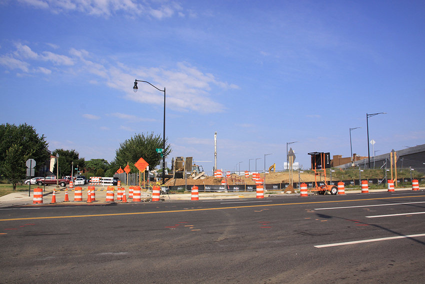
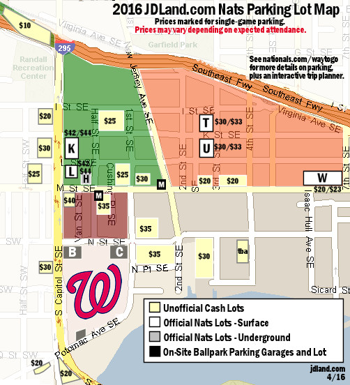 Thanks to a trek around the neighborhood on Saturday (instead of being inside the stadium watching baseball like a normal person) and some checking in with property owners, I've got a pretty solid version of my Nats Park Parking Lots Map to share for the 2016 season.
The big news at this point is that no lots have dropped out of the inventory (yet!), and one has returned--the lot on the northeast corner of 1st and N, SE, on the Spooky Park block, now a nicely paved and compact 220-space offering.
There will also apparently be "limited" parking in the new underground garage in Arris, on 4th Street south of Tingey.
Prices have nudged upward from last year, though--and if you are driving to Opening Day, throw a few extra $5 bills in your wallet, because home opener prices will likely be higher than what the map is showing.
Some cash lot parking attendants were quick to tell me Opening Day prices, and others had more of a "Well, we'll see what the market will bear" response, so instead of my listing them here and having them turn out to be wrong, better for you to just expect to pay $5 or $10 or $15 or even $20 more than "standard pricing" on Thursday and then be thrilled if you don't have to.
It's also possible that some lots (especially east of the stadium, in the Yards) may have slightly lower prices at points in April, when attendance isn't at its height.
In other words, consider this a guide to the general range of prices, while always expecting the possibility that prices may be different on any given day.
If you are driving to the ballpark, be aware that there are still lots of construction sites, and that in particular the Virginia Avenue Tunnel project immediately south of the Southeast Freeway between 2nd and 12th Streets, SE, has ripped the streets up pretty good, with various closures and shifts to watch out for.
Check out my Stadium Parking and Visiting Nats Park pages for additional info.
|
Comments (1)
More posts:
parking, Nationals Park, Traffic Issues
|
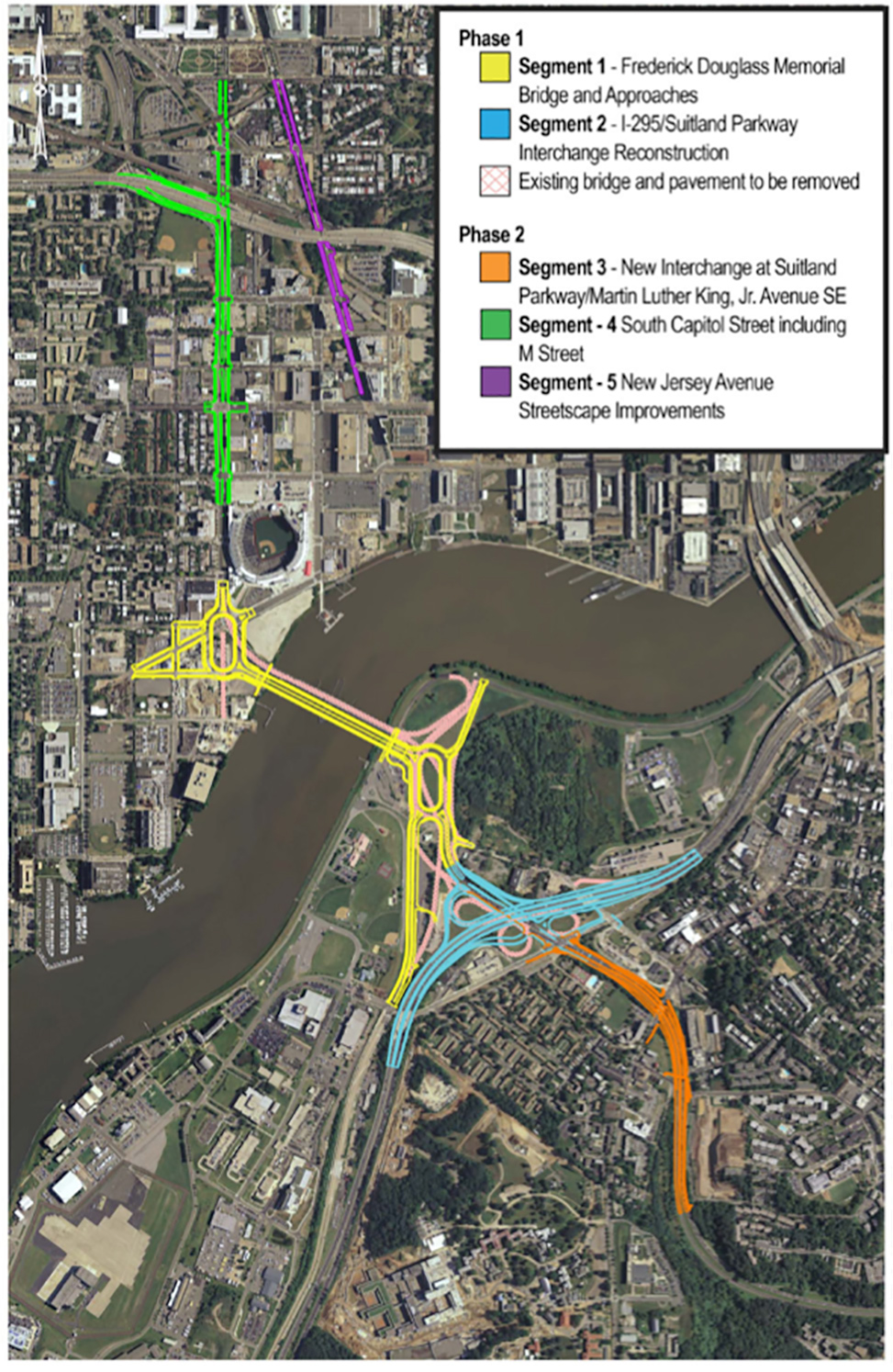 More than two years after four teams were shortlisted for the opportunity to compete for the project, DDOT announced today that it has issued the final Request for Proposals (RFP) for the first phase of the South Capitol Street Corridor reconstruction, which includes a new Douglass Bridge and approach work, plus a new interchange at I-295 and the Suitland Parkway.
The release today says that design/build proposals from the four teams are due this fall, and that DDOT expects to begin construction in the spring of 2017, and complete this first phase in 2020, but, well, We Shall See.
I absolutely cannot bear to write about this in any detail AGAIN, so if you haven't been keeping up with the plans to replace the existing 67-year-old bridge, please check out my post from August 2015, when it was announced that the project got its federal approval/record of decision, or my post from late 2014 about the supplemental EIS that presented some tweaks to the plan that had been stalled after a preferred alternative was identified back in 2011.
But if clicking on one of those links is more than you yourself can bear, I will just plagiarize the summary I wrote in August:
As you can see in the pilfered-from-DDOT graphic above, the new bridge will run immediately parallel and downriver of the existing bridge, with two new large traffic ovals on its approaches. There will also be a much-needed reconstruction of the I-295/Suitland Parkway interchange.
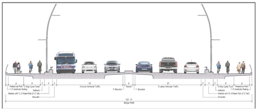
The bridge will have three travel lanes in each direction, along with 18-feet-wide pedestrian/bike paths on both the up-river and down-river edges of the bridge, which will be configured as one 8-foot-wide lane for pedestrians and a 10-foot-wide bidirectional bike path.
The eventual second phase of this overall "South Capitol Street Corridor Project" will be streetscape improvements to the north end of the street, similar to the spiffening that the blocks from N to Potomac received back in 2007 that give the street more of an "urban boulevard" feel. This will include a full redesign of the M Street intersection and a reconfiguration of South Capitol's interchange with I-395.
My South Capitol Street and South Capitol Street Bridge project pages are also good places to go for details.
|
Comments (9)
More posts:
South Capitol St., Douglass Bridge, Traffic Issues
|
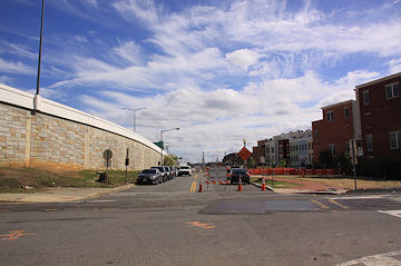
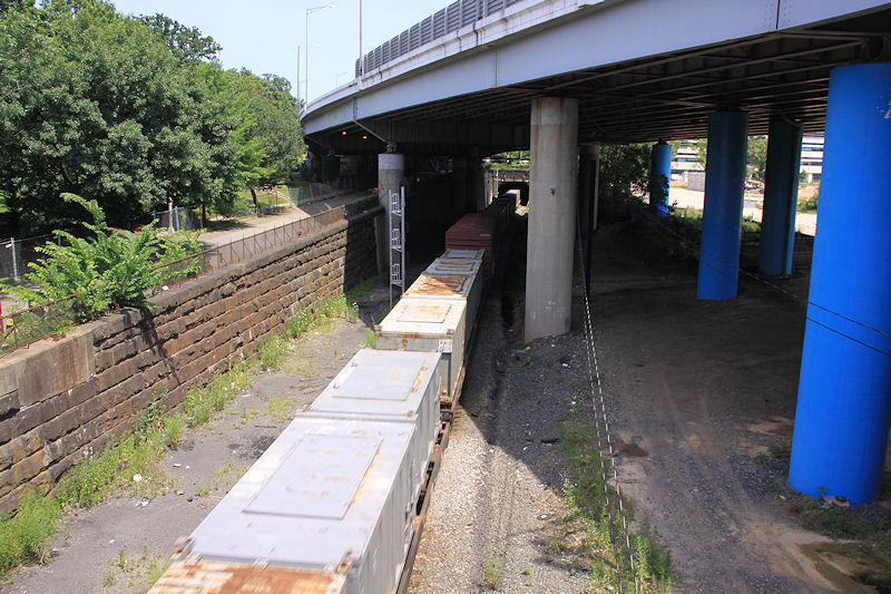
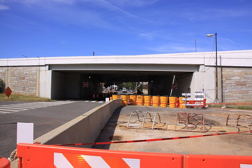
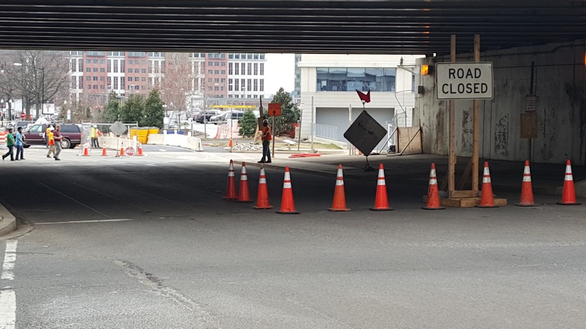 I happened to wander up and down 3rd Street a couple of times on Thursday, and so got a good look at how the street is now temporarily set up as CSX works to build the temporary decking over the tunnel construction at the intersection with Virginia Avenue.
As mentioned a few days back, it was decided that instead of closing the intersection altogether, traffic would become one way northbound during the deck construction, with any traffic headed south of the freeway needing to turn left at G Street and then right on 4th Street to come under the freeway. But traffic can still come south of G in order to turn left into the Results parking lot or right to take the 3rd Street ramp to the Southeast Freeway.
As you can see in these terribly exciting photos, northbound traffic is currently in a small "chute" of sorts just south of Virginia, just west of where digging has begun. Then the area opens up under the freeway.
Pedestrians heading either north or south of the freeway are on the sidewalk on the east side, then must cross to get to a temporary walkway west of the "chute" on the south side of the intersection.
I went by about four times, at 1:30, 3:00, 5:00, and 8:30 pm. I saw no big backups on either side of the freeway, though did see one person turn into the Results driveway to then backup and head north back to G.
There are flaggers watching the traffic during construction hours (and also were taking a few seconds to glare pointedly at crazy ladies taking photos of the configuration), but when I passed by at 8:30, there were no workers on site, and I watched two vehicles come south under the freeway past the Road Closed signs. There was no northbound traffic, so they were able to do it, but it's something that people using that intersection outside of the hours that the workers are on site might want to be watching for.
I asked CSX representatives about the first few days of work, and whether there might be any tweaks coming now that they've seen it in action. This is their statement:
"We appreciate the community’s patience and cooperation as we work to install the temporary street deck at the intersection of 3rd Street and Virginia Avenue. CSX is working as quickly as safety allows to install the temporary bridge and restore two-way traffic to 3rd Street. In the meantime, in conjunction with DDOT’s traffic experts, we continue to make adjustments to the directional signs and traffic control devices through the 3rd Street and Virginia Avenue intersection, to optimize the flow of traffic through the area. We are placing new signs north of G Street on 3rd Street to help increase awareness of the one-way traffic below the freeway, and are hopeful that more drivers will obey the signs as they become familiar with the temporary changes."
As the deck construction eventually works its away across the entire intersection, watch for the patterns to change. It is expected to be "several weeks" before the deck is completed and two-way traffic is restored.
If you have questions or concerns about this or any other part of the Virginia Avenue Tunnel construction, the next Coffee with Chuck is on Wednesday, March 16, at 8 am.
PS: Thanks to all who came to Scarlet Oak for Happy Hour on Thursday! It was great meeting a lot of readers and commenters "in real life," and I think there maybe ought to be another one before too much longer. Once I get my voice back--I'm not used to actually talking to human beings that much.
|
Comments (4)
More posts:
CSX/Virginia Ave. Tunnel, Traffic Issues
|
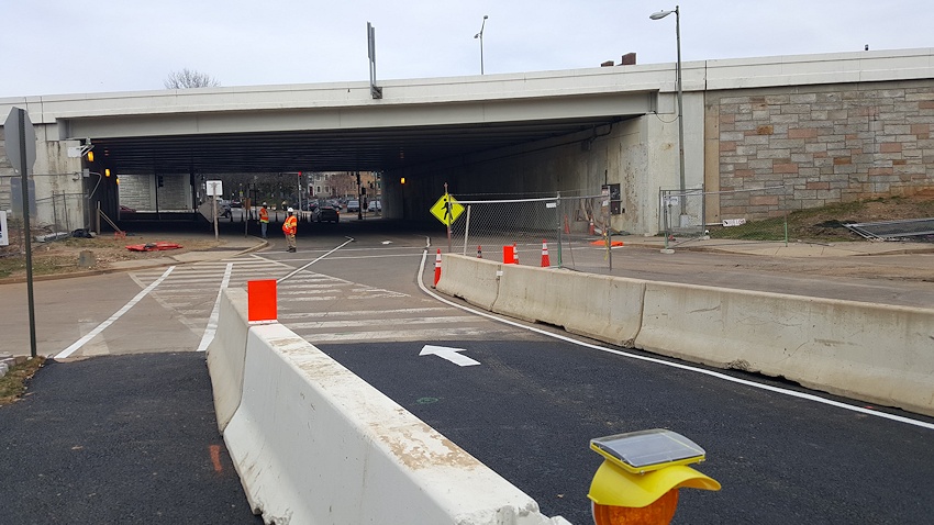
 The original plan to temporarily close 3rd Street SE in both directions for a few weeks to allow the construction of a "deck" over the Virginia Avenue Tunnel construction footprint has apparently been rethought, according to a missive this morning from CSX.
Later this week, 3rd Street will be restricted to a single lane of traffic, northbound, from a little ways north of I Street up until through the light just north of the freeway overpass.
In other words, if you want to drive from north of the freeway to south of the freeway, you won't be able to do it on 3rd Street until after the temporary decking is built, which is expected to take "several weeks." At that point, two-way traffic will be reestablished.
Fourth Street will be the fall-back for heading southward, so if you are coming south on 3rd, you'll need to turn left at G Street (the "Results" block) and then right on 4th. (If you are southbound on 3rd, you will still be able to turn right onto the freeway ramp.)
CSX says that "the new plans were developed with DDOT’s approval following community requests to avoid closing 3rd Street during the tunnel project, especially in light of traffic associated with baseball games at Nationals Park."
In other tunnel news, "CSX is pleased to announce that the street-level portion of the demolition of 370 feet of the existing tunnel in the 200 block of Virginia Avenue has been completed several weeks ahead of schedule. While some track-level demolition remains to be completed, the noise associated with this work should diminish significantly for residents near the intersection of 3rd Street and Virginia Avenue, and no additional early-morning or Sunday demolition work periods are expected."
PS: Not my greatest headline, but thanks to the world of search-engine-optimized URLs, it's kind of bad to change it after I've tweeted/Facebook'ed the link. Was trying to make clear from the headline that people coming south from the Hill will be impacted, but it's really just at the Virginia Avenue intersection where the construction is taking place.
|
Comments (9)
More posts:
CSX/Virginia Ave. Tunnel, Traffic Issues
|
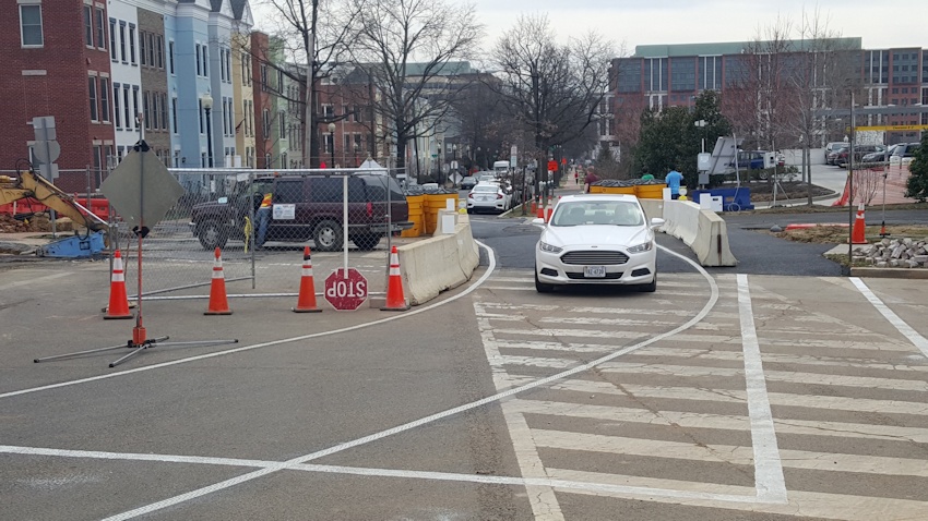
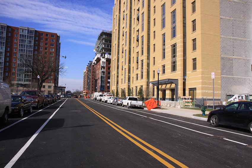
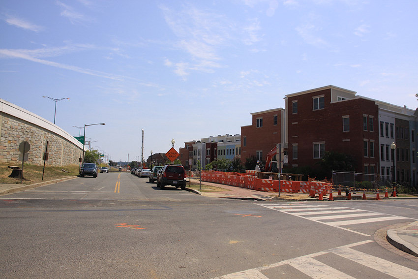
I think a couple of before-and-afters tell the story as well as a pile of words. First, looking west from 2nd Street SE on Feb. 3, 2005, and then today, Feb. 8, 2016: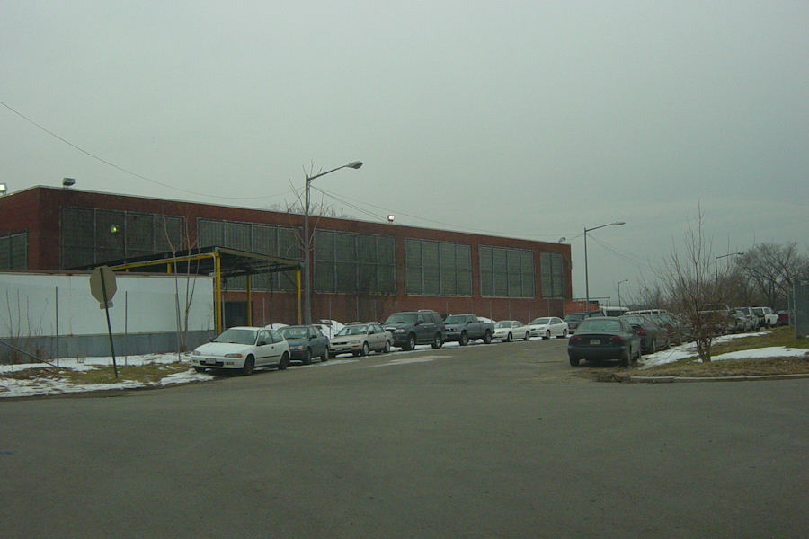

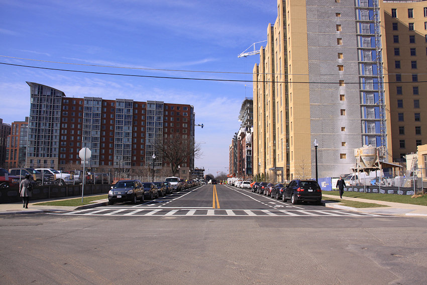
And the reverse view, looking east from New Jersey on Feb. 23, 2004 and today, Feb. 8, 2016:

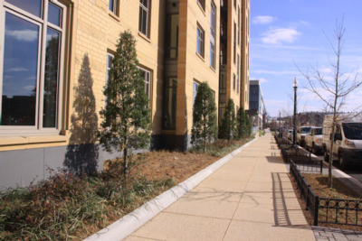
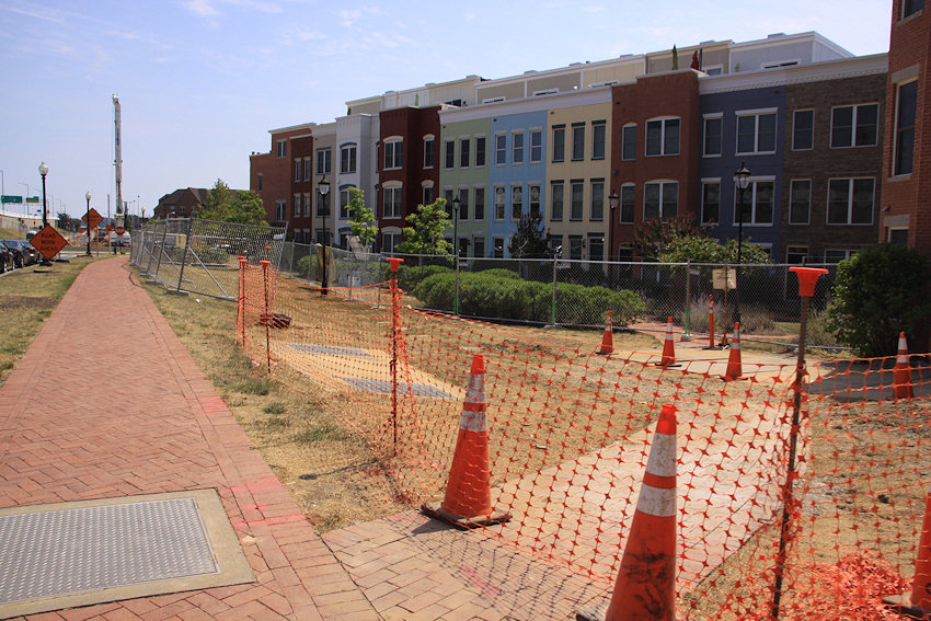
And here's a few more shots, because I'm a crazy woman. Note that the sidewalks on the south and west sides of the Park Chelsea are now open, meaning that you can now walk on the east side of New Jersey north of I--at least until you get to the fences that mark the Agora/Whole Foods project, at which point you'd need to cross back to the west.


In case you haven't been around, it was the former DPW/trash transfer station, demolished in 2012, that long ago was built on a diagonal footprint, created from back when the Washington Canal was dug.
And now I at last will be able to photograph the intersections of 2nd and I and New Jersey and I without having to walk down to K and back up to I. And bike to Southwest without having to do the same down-and-back.
I would note, though, that pedestrians and cyclists need to be veeeeeery careful at this intersection--I saw a lot of confusion this morning, and of course the continuing construction right up to the property line at 82 I adds to the difficulties.
|
Comments (19)
More posts:
880 NJ/Park Chelsea, parkchelsea, Traffic Issues
|
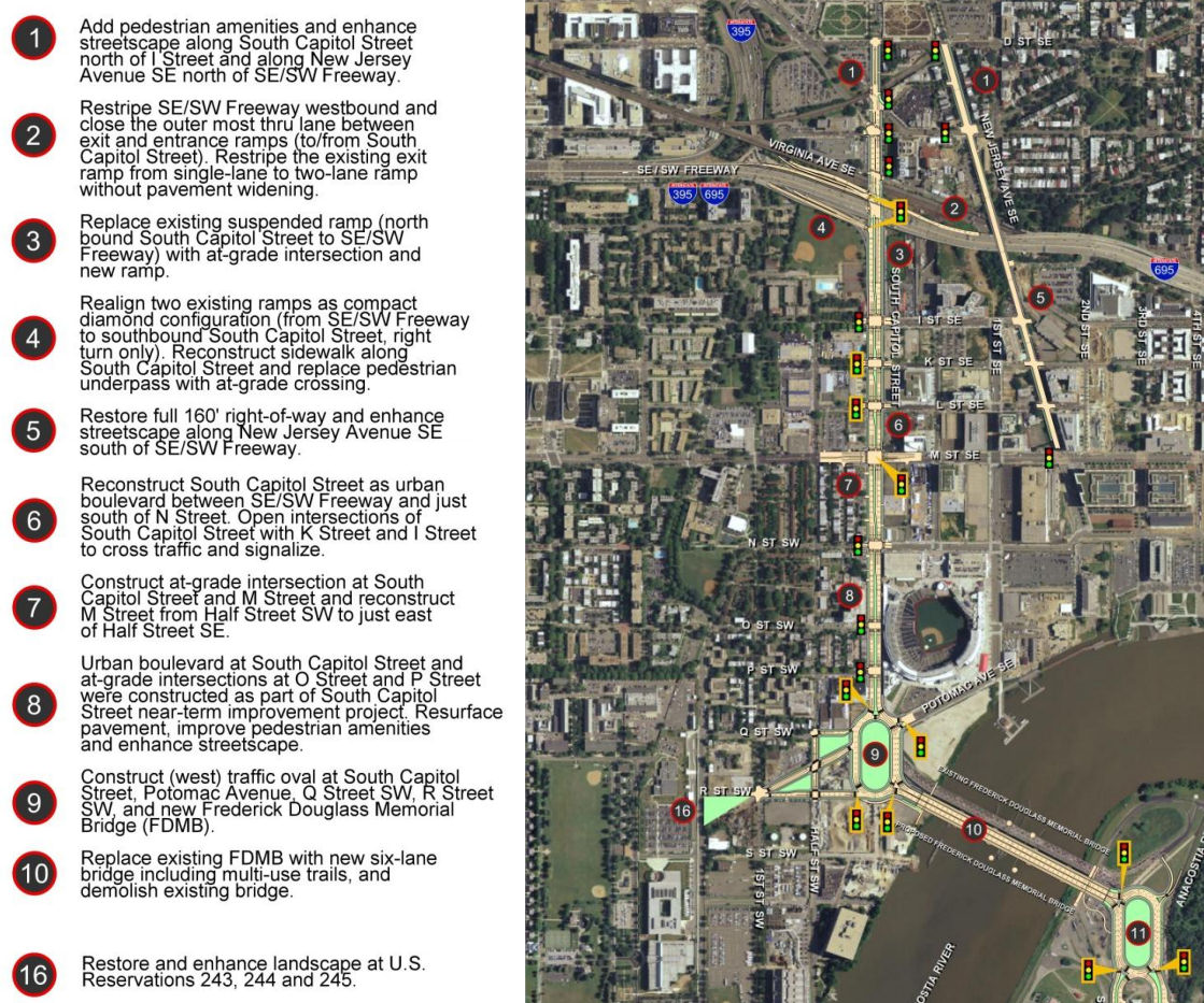
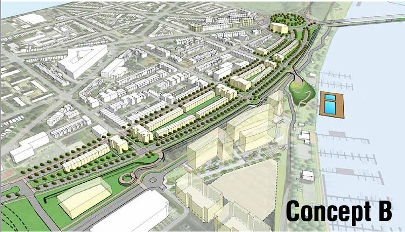 Last week DDOT released its Southeast Blvd. Feasibility Study, in which the agency "evaluated the feasibility of transitioning a segment of the former Southeast Freeway from 11th Street to Barney Circle into an urban boulevard more consistent with the expected travel demand and the character of the adjacent neighborhood."
 This study was a follow-on to the Office of Planning's Southeast Blvd. Planning Study, which came about after residents expressed displeasure with the initial efforts seen in the Barney Circle-Southeast Blvd. Transportation Planning Study.
And what does the feasibility study say? DDOT's report determines that changing the current Southeast Blvd. from the limited-access quick route between 11th Street SE and Barney Circle to a street with connections to its north and south and development along the footprint is feasible, but the transformation "would be neither inexpensive nor quick."
The study then goes through the issues that make clear this would not be a snap-the-fingers-and-make-it-so proposition:
*Ownership: There are two small parcels within the study area owned by the National Park Service--and we know quickly either arranging for a change in ownership or "coordinating" with NPS can go. The study refers to it as being clear "that there would be significant process requirements and challenges to disposing the NPS and incorporating them into private development." That the process to "surplus" any excess land along the footprint not needed for the road(s) itself is governed by the Federal Highway Administration would also not point to a lightning-quick resolution.
* Transit Garages: The inclusion of some location that would allow for the parking of tour buses, transit buses and streetcars {cough}--a big part of DDOT's wishes for the area but something that residents are not particularly keen on--"could be provided at Southeast Boulevard that takes advantage of the location and topography of the site to minimize visual impacts to surrounding neighborhoods and so that vehicles accessing the facility would not use residential neighborhood streets."
* Cost: The study's "cursory assessment" says that constructing the transportation elements of the project would cost around $120 million, with a transit garage adding about $65-70 million in costs (in 2015 dollars). This includes reconfiguring Barney Circle into an at-grade signalized traffic circle, raising Southeast Boulevard to the same level as L Street, and constructing a four-lane street that includes sidewalks, bike facilities, and traffic signals. Plus some contingency costs built in.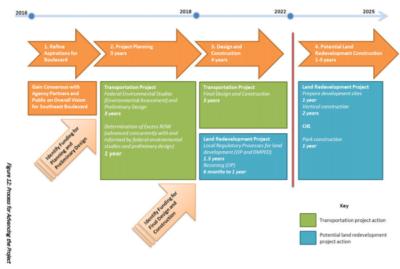
* Schedule: The graphic at right breaks out a not-short ballpark timeline of 10 years for both the "transportation" portion of the project and the land redevelopment project.
With all of that, DDOT says that the first step forward is to restart the Barney Circle and Southeast Blvd. Transportation Planning Study begun in 2013, though even that now has a road block, that this Environmental Assessment now can't be completed "until a financial plan for project implementation is identified and included in the regional Constrained Long-Range Transportation Plan (CLRP)." DDOT advises interested groups "to continue discussions with a broad spectrum of stakeholders during the EA to confirm community support for the project, engage with AWI Signatories, and evaluate project costs and funding options."
This final draft was presented to ANC 6B's Transportation Committee on Jan. 6, and Capitol Hill Corner reports that DDOT's representative told the committee that there were no "fatal flaws" in any of the Office of Planning's three concepts for reimagining the road--but that it will be "up to ANC 6B to push the project forward" by requesting the environmental assessment.
I am skimming it all, so if this project is of interest to you, be sure to read the feasibility report, and perhaps attend ANC 6B's meeting on Jan. 12, at which a draft letter will apparently be considered to support going ahead with the EA.
You can also wander through my posts on the subject from the past few years, especially on the completion of the OP study back in July and the three general concepts advanced for how to remake this stretch of land that currently serves as such a barrier between Capitol Hill/Hill East and the Anacostia River.
|
Comments (7)
More posts:
Southeast Blvd., Traffic Issues
|
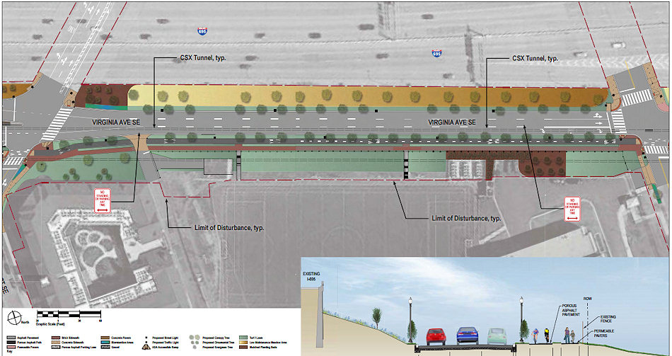
 I did not attend last week's meeting on the plans for Virginia Avenue's streetscape once construction on the tunnel is completed, but detailed notes taken by DDOT have been posted. And there are some items that caught my eye:
* TREES: It's reported that 176 trees have been cut down as part of the tunnel construction, and that there will be approximately 305 new trees planted once the work is done. DDOT's preferred species include oaks, elms, and honey locust, and the planting scheme is such that it is expected to provide 50 percent "canopy coverage" after 20 years, 10 percentage points higher than the required minimum.
* PARKING: "The design team recognizes that parking is a critical issue for the neighborhood, and will ensure that the number of parking spaces in the neighborhood remains the same. DDOT will explore the possibility of providing additional parking."
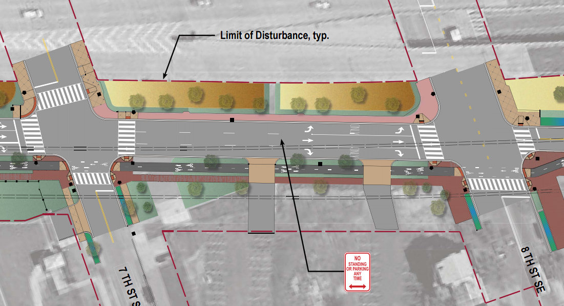
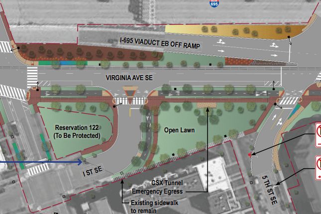 * I STREET: Plans to have the 400 block of I Street end in a stub east of the church have apparently been shelved: "Based on community feedback, the connection of I Street to the 400 block of Virginia Avenue has been restored." As seen in this revised image.
* MORE VIRGINIA!: My personal favorite out of all of this: "The Architect of the Capitol will complete their construction project in 2018, and has indicated willingness to reopen Virginia Avenue between South Capitol Street and 2nd Street SE." This would also "enhance" connections to Garfield Park, allowing for passage in locations other than just the skate park-area under the freeway.
* TWO-WAY: Once construction is over, the 800 blocks of both Virginia Avenue and L Street SE will be converted to two-way traffic.
* LIGHTING: Replacement streetlights will be LEDs, which emit a whiter light than the current streetlights. There are apparently LED streetlights now installed on 1st Street near the ballpark as a test case for the city, and the "fixtures specified for Virginia Avenue will be similar to the first series of lights on the right hand side of First Street moving away from M Street."
* VIRGINIA AVE. PARK: The final post-construction design of Virginia Avenue Park is actually the responsibility of the Department of Parks and Recreation, and there will be a "design charrette" to discuss the park's future on Oct. 15 at 7 pm at the Hill Center, 921 Pennsylvania Ave., SE.
Go ahead and read the notes for more details (and you can even see all the comment sheets handed in by the attendees). And the most recent designs for the streetscapes are here, plus you can check out my look at the initial designs.
|
Comments (9)
More posts:
CSX/Virginia Ave. Tunnel, meetings, Traffic Issues
|
Some transportation-related meetings are on the calendar for next week that may be of interest to neighborhood folks: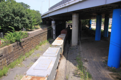 * DC STATE RAIL PLAN OPEN HOUSE: The project to create an official "State Rail Plan" (ahem) for DC is kicking off, and DDOT is holding an open house on Monday, Sept. 28 to "introduce the plan to the community." This rail plan is a requirement for any state (again, ahem) wishing to be eligible for grants and other federal financial assistance, and is going to focus on "passenger and freight rail infrastructure shared by CSX, VRE, MARC, Amtrak, and Norfolk Southern." The intent is to have a completed plan that will provide a high-level strategic framework, goals, and objectives to leverage the District’s rail network for continuing economic competitiveness and quality-of-life investments while also addressing ongoing concerns about rail safety and oversight."
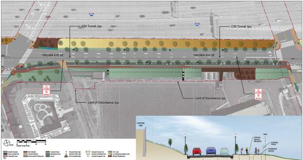 * VIRGINIA AVE. STREETSCAPE RESTORATION REVIEW MEETING: Also on Monday, Sept. 28, beginning at 6:30 pm at 200 I St. SE, a joint meeting by DDOT and ANCs 6B and 6D will go over CSX's draft plans for rebuilding Virginia Avenue once construction is complete on the Virginia Avenue Tunnel. The first 30 minutes will be an open house, and then presentations and discussions will begin at 7 pm. There will also be a special public meeting of DDOT's Public Space Committee about the plans on Nov. 12.
 * CIRCULATOR STOP CONSOLIDATION MEETING: On Wednesday, Sept. 30, DDOT is having a public meeting to talk about possibly consolidating some stops on the Union Station-Navy Yard line "to improve on-time performance and reliability." The only south-of-the-freeway stops on the potential chopping block are the ones at 4th and M SE in both directions, with the 6th and M stops being the closet ones to use instead. (The announcement gives the full lineup.) The meeting is from 6pm to 8pm at the Southeast Neighborhood Library, 403 7th Street SE.
 * DC STATE RAIL PLAN OPEN HOUSE: The project to create an official "State Rail Plan" (ahem) for DC is kicking off, and DDOT is holding an open house on Monday, Sept. 28 to "introduce the plan to the community." This rail plan is a requirement for any state (again, ahem) wishing to be eligible for grants and other federal financial assistance, and is going to focus on "passenger and freight rail infrastructure shared by CSX, VRE, MARC, Amtrak, and Norfolk Southern." The intent is to have a completed plan that will provide a high-level strategic framework, goals, and objectives to leverage the District’s rail network for continuing economic competitiveness and quality-of-life investments while also addressing ongoing concerns about rail safety and oversight."
The open house will run from 5:30 pm to 7:30 pm at Friendship Public Charter School-Chamberlain Campus, 1345 Potomac Avenue, SE. This start time is 30 minutes earlier than originally announced, because....:
 * VIRGINIA AVE. STREETSCAPE RESTORATION REVIEW MEETING: Also on Monday, Sept. 28, beginning at 6:30 pm at 200 I St. SE, a joint meeting by DDOT and ANCs 6B and 6D will go over CSX's draft plans for rebuilding Virginia Avenue once construction is complete on the Virginia Avenue Tunnel. The first 30 minutes will be an open house, and then presentations and discussions will begin at 7 pm. There will also be a special public meeting of DDOT's Public Space Committee about the plans on Nov. 12.
(And then maybe for Christmas we can pitch in and get DDOT a group calendar, to perhaps avoid in the future scheduling two meetings with a very similar audience on the same night at nearly the same time in not-particularly-adjoining locations.)
* CIRCULATOR STOP CONSOLIDATION MEETING: On Wednesday, Sept. 30, DDOT is having a public meeting to talk about possibly consolidating some stops on the Union Station-Navy Yard line "to improve on-time performance and reliability." The only south-of-the-freeway stops on the potential chopping block are the ones at 4th and M SE in both directions, with the 6th and M stops being the closet ones to use instead. (The announcement gives the full lineup.) The meeting is from 6pm to 8pm at the Southeast Neighborhood Library, 403 7th Street SE.* CSX'S "COFFEE WITH CHUCK": If you want to go for the 72-hour quadfecta of transportation sessions, there's also the next edition of CSX's monthly meetings with the community to discuss the Virginia Avenue Tunnel project, on Wednesday, Sept. 30 from 8 to 9 am at the Courtyard by Marriott at 140 L St. SE. Items that might be up for discussion include the coming closure of the 300 block of Virginia Ave. (in "early October") and also the temporary closures of 4th Street SE from just north of the I-695 underpass down to I Street from 9:30 am to 3:30 pm this week and probably into next week.
|
Comments (6)
More posts:
Pedestrian/Cycling Issues, circulator, CSX/Virginia Ave. Tunnel, meetings, Traffic Issues
|
I recently took you along the multiple blocks of Virginia Avenue that are in the process of getting dug up as part of CSX's tunnel expansion and reconstruction project. But even though it's going to be a few years before the tunnels are completed, the process is underway to talk about what Virginia Avenue will look like after the construction is over.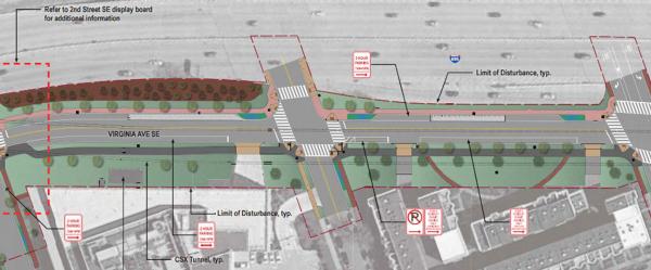

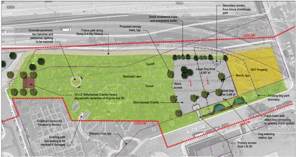 East of 9th, into Virginia Avenue Park, the path being built by CSX disappears, but the park design seen at right shows a path that runs along the north end of the park to 11th Street, where we can all dream of a day that it hooks up with the path that is supposed to be built alongside Southeast Blvd. to Barney Circle, making for an alternate route to the Anacostia Riverwalk Trail near RFK without having to go along M Street SE.
CSX is in charge of this streetscape-and-landscaping upgrade and has submitted draft plans to various groups for review, and has posted some big (BIG) PDFs on the project web site. Meanwhile, ANC 6D commissioner Meredith Fascett put out the call last week looking for volunteers to join a neighborhood working group on the restoration plans.
But for those who don't want to wade through the PDFs, here are some partial screen grabs of CSX's submittals for the new Virginia Avenue, and I'm sure the bike/ped paths (both shared and separate) will be of interest, along with the plans to perk up Virginia Avenue Park.
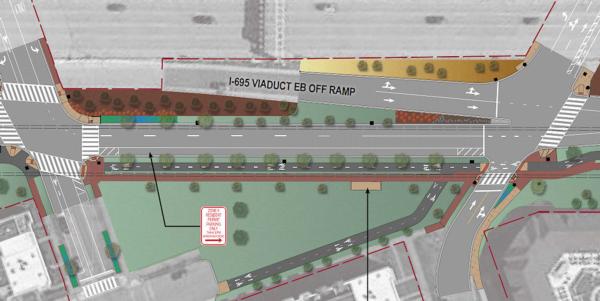
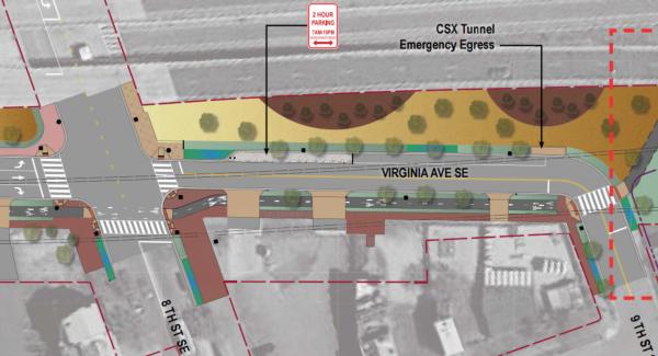
These first two screen grabs show the general landscape and "roadway" plans from 2nd to 4th Street, and from 4th to 5th (click to enlarge):
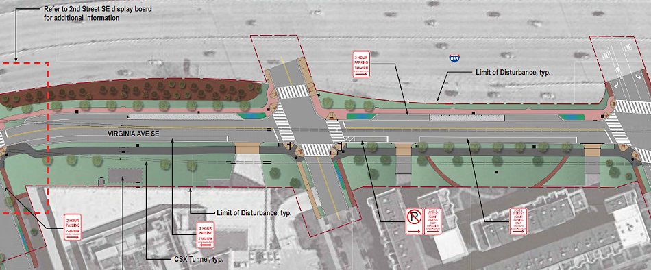
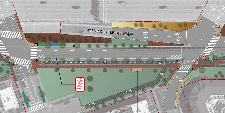
For the westernmost blocks, there will be a shared porous asphalt path on the street's south side. Then, starting at 4th Street, there will be separate asphalt bike path and a companion walking path with permeable pavers. The second image also shows the expanded pocket park between 4th and 5th that will be created thanks to the planned realignment of Virginia. Note that it also has a bike path that runs down to the I Street stub--which will make for a decent cut-over to I and its bike lanes from 3rd St. SE all the way into Southwest (well, once that little part between 2nd and New Jersey opens!).
The split paths continue from 5th Street to 9th Street, as you see below (once you click to enlarge, that is):

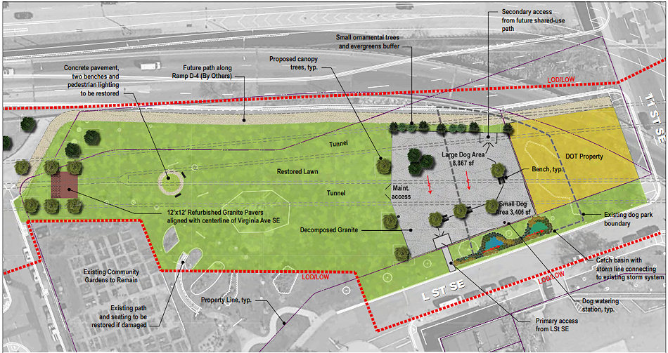 East of 9th, into Virginia Avenue Park, the path being built by CSX disappears, but the park design seen at right shows a path that runs along the north end of the park to 11th Street, where we can all dream of a day that it hooks up with the path that is supposed to be built alongside Southeast Blvd. to Barney Circle, making for an alternate route to the Anacostia Riverwalk Trail near RFK without having to go along M Street SE.
As for the park itself, the current dog park will be reconfigured, with both "large dog" and "small dog" areas. Some of the original paving stones recently uncovered will be placed in the park as well.
A public meeting to receive resident comments and feedback is expected to be happening soon, which I'm sure will be announced two minutes after I finish this post. UPDATE: Yup, less than 24 hours later, I'm seeing that the public meeting will be on Monday, Sept. 28 at 6:30, at a location to be determined.
Take a look at the full lineup of PDFs for better detail.
UPDATE, 10/7: After the meeting, updated block-by-block designs were made available (including a revision to reestablish the connection between the 400 block of I Street and Virginia Avenue), along with notes from the meeting.
|
Comments (4)
|
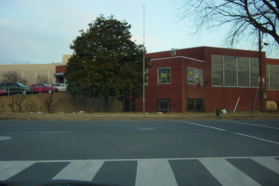
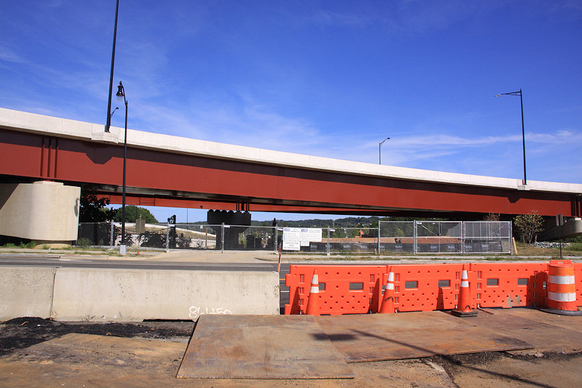
 If you are not one who sees much of Virginia Avenue SE in your day-to-day travels, or if you just cross it on your way to other locations, you might not be fully aware of the current scope of the initial work on the Virginia Avenue Tunnel reconstruction.
 But never fear, my feet and my camera worked very hard in recent days to bring it all together for you.
Let's take a walk from west to east, shall we?
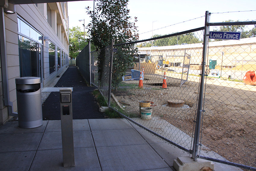 * FROM 2ND TO 3RD: The little-used stretch of Virginia from where the tracks first go underground at 2nd Street east toward 3rd was the first to close, depriving me of a good Park Chelsea/800 New Jersey vantage point (waaah!).
 There's still pedestrian access right up against 200 I as you see at right, but the street itself is mostly gone, except for the portion that allows access to 200 I's loading dock.
* FROM 3RD TO 4TH: The thorniest part of the entire project is of course the 300 block of Virginia, where the townhouses on the south side of the block are taking the lion's share of residential impact during the reconstruction. As you see below, the trees along both sides of the street are gone, and access to the houses' front sidewalk from the east end is gone, as prep work is done for a new temporary driveway from 3rd Street to the alley that runs behind the houses. It's anticipated that this block will close to traffic completely next month.
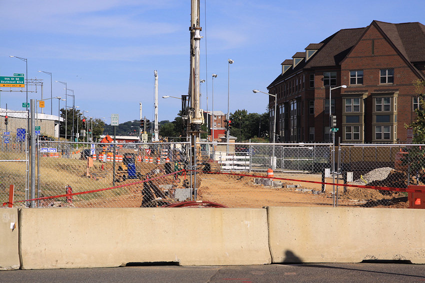
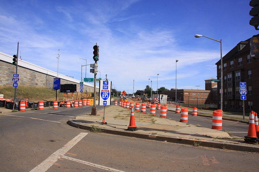
* FROM 4TH TO 5TH: The intersection of 4th and Virginia is shrinking as prep work begins to build the temporary decking that will allow traffic to cross over the tunnel construction. The stretch from 4th to 5th has been stripped of its asphalt, as you see in the second photo below and the one at the top of this post. You can also see in the below right photo why there will be a temporary closure for a few weeks next spring of the 6th Street exit ramp from the freeway, so that it can be shifted north to allow for tunnel work.
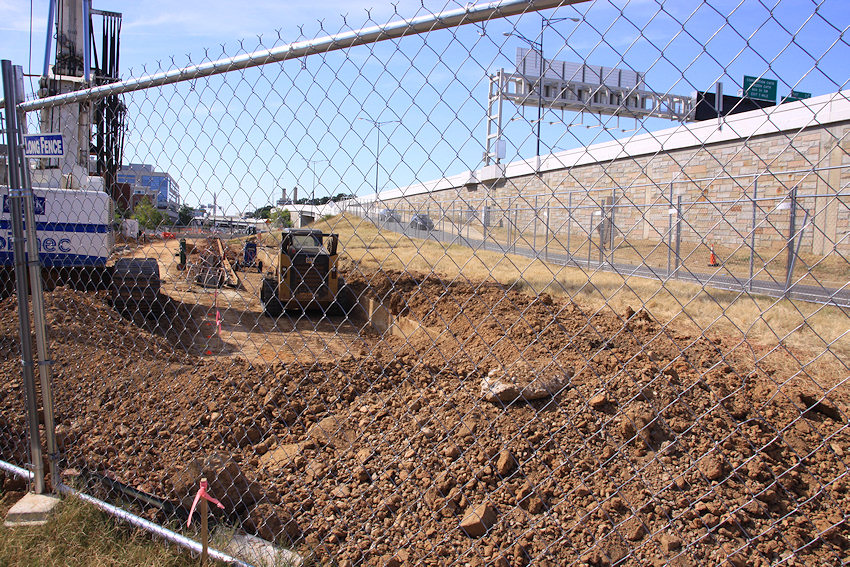
* FROM 5TH TO 7TH: Those coming down the freeway ramp are now greeted with a sea of orange, and with the loss of the right lane. (And pedestrians have lost any sidewalk access to this block.) This block will remain open with reduced lanes into 2017.
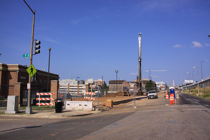
 * FROM 7TH TO 9TH: The small stretch of Virginia between 7th and 8th is currently untouched, but the street is closed from east of 8th to 9th (as I grumble about how part of this area was JUST ripped up and rebuilt as part of the 11th Street Bridges project).
 With help from a tree stump, I was able to get a look at not only the initial work on Virginia but the clearing of a big chunk of Virginia Avenue Park, all the way across to 11th Street. The community garden remains untouched, however.
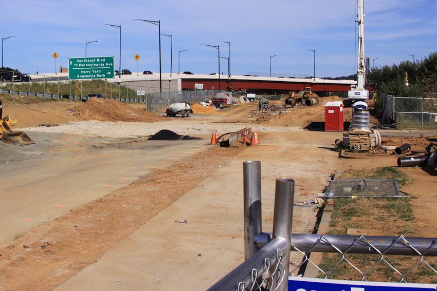
* FROM 10TH TO 12TH: The construction bends south in Virginia Avenue Park to meet up with L Street at 10th (below left), and L is now closed at its intersection with 11th (below middle). East of 11th the construction site continues (below right), but after all of this walking I failed you and did not get across there to peek in. It's in this final section where CSX reports having found more than 8,800 original paving stones buried a few feet below ground, apparently laid sometime during the 1880s-1890s. CSX says it will use some of the stones in its restoration of Virginia Avenue Park and will provide the rest to DDOT.
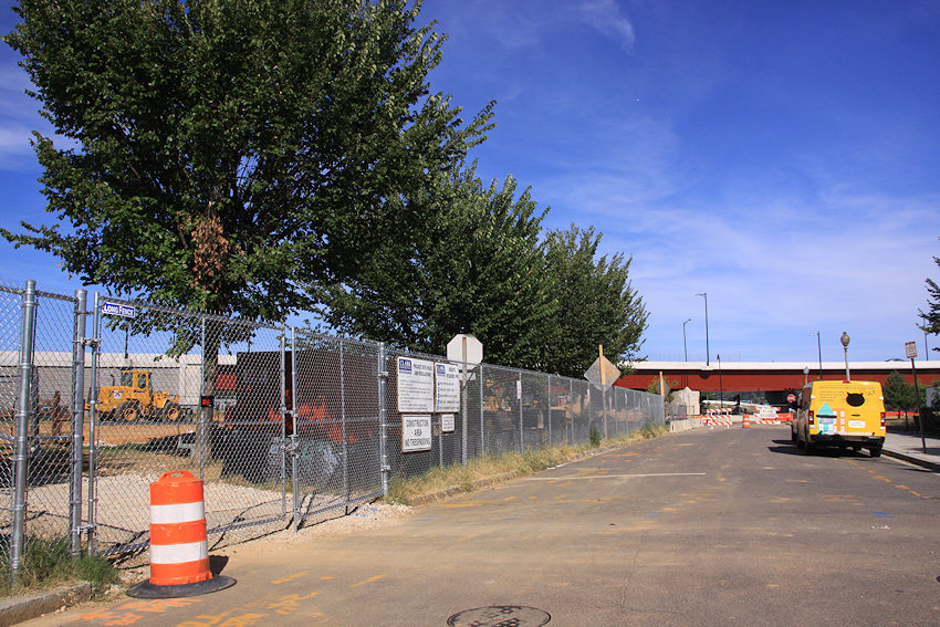
The sidewalk on the west side of 11th between the freeway and M Street is closed, but a recent missive from CSX says this is temporary "while we install pilings and temporary bridge decks, and work on utility relocations."
E-mail updates on closures and other construction aspects are sent out by the project team pretty regularly, if you are not already signed up. The next monthly "Coffee with Chuck" meeting with the project's chief engineer is scheduled for Sept. 30 at 8 am at the Courtyard by Marriott. (Though perhaps at some point though there needs to be a "Warm Milk/Nightcap with Chuck" for folks who don't operate well before noon.)
And my Virginia Avenue Tunnel project page is now refreshed with a fair number of before-and-after pairings to be able to see the changes at the various intersections along the construction footprint.
|
Comments (3)
More posts:
CSX/Virginia Ave. Tunnel, Traffic Issues
|
251 Posts:
Go to Page: 1 | 2 | 3 | 4 | 5 | 6 | 7 | 8 | 9 | 10 ... 26
Search JDLand Blog Posts by Date or Category
Go to Page: 1 | 2 | 3 | 4 | 5 | 6 | 7 | 8 | 9 | 10 ... 26
Search JDLand Blog Posts by Date or Category