
|
| |||||||||||||||||||

|
Please note that JDLand is no longer being updated.
peek >>
Near Southeast DC Past News Items: Traffic Issues
- Full Neighborhood Development MapThere's a lot more than just the projects listed here. See the complete map of completed, underway, and proposed projects all across the neighborhood.
- What's New This YearA quick look at what's arrived or been announced since the end of the 2018 baseball season.
- Food Options, Now and Coming SoonThere's now plenty of food options in the neighborhood. Click to see what's here, and what's coming.
![-]()
- Anacostia RiverwalkA bridge between Teague and Yards Parks is part of the planned 20-mile Anacostia Riverwalk multi-use trail along the east and west banks of the Anacostia River.
![-]()
- Virginia Ave. Tunnel ExpansionConstruction underway in 2015 to expand the 106-year-old tunnel to allow for a second track and double-height cars. Expected completion 2018.
![-]()
- Rail and Bus Times
Get real time data for the Navy Yard subway, Circulator, Bikeshare, and bus lines, plus additional transit information. - Rail and Bus Times
Get real time data for the Navy Yard subway, Circulator, Bikeshare, and bus lines, plus additional transit information. - Canal ParkThree-block park on the site of the old Washington Canal. Construction begun in spring 2011, opened Nov. 16, 2012.
![-]()
- Nationals Park21-acre site, 41,000-seat ballpark, construction begun May 2006, Opening Day March 30, 2008.
![-]()
- Washington Navy YardHeadquarters of the Naval District Washington, established in 1799.
![-]()
- Yards Park5.5-acre park on the banks of the Anacostia. First phase completed September 2010.
![-]()
- Van Ness Elementary SchoolDC Public School, closed in 2006, but reopening in stages beginning in 2015.
![-]()
- Agora/Whole Foods336-unit apartment building at 800 New Jersey Ave., SE. Construction begun June 2014, move-ins underway early 2018. Whole Foods expected to open in late 2018.
![-]()
- New Douglass BridgeConstruction underway in early 2018 on the replacement for the current South Capitol Street Bridge. Completion expected in 2021.
![-]()
- 1221 Van290-unit residential building with 26,000 sf retail. Underway late 2015, completed early 2018.

- NAB HQ/AvidianNew headquarters for National Association of Broadcasters, along with a 163-unit condo building. Construction underway early 2017.

- Yards/Parcel O Residential ProjectsThe Bower, a 138-unit condo building by PN Hoffman, and The Guild, a 190-unit rental building by Forest City on the southeast corner of 4th and Tingey. Underway fall 2016, delivery 2018.

- New DC Water HQA wrap-around six-story addition to the existing O Street Pumping Station. Construction underway in 2016, with completion in 2018.

- The Harlow/Square 769N AptsMixed-income rental building with 176 units, including 36 public housing units. Underway early 2017, delivery 2019.

- West Half Residential420-unit project with 65,000 sf retail. Construction underway spring 2017.
![-]()
- Novel South Capitol/2 I St.530ish-unit apartment building in two phases, on old McDonald's site. Construction underway early 2017, completed summer 2019.
![Novel South Capitol]()
- 1250 Half/Envy310 rental units at 1250, 123 condos at Envy, 60,000 square feet of retail. Underway spring 2017.
![-]()
- Parc Riverside Phase II314ish-unit residential building at 1010 Half St., SE, by Toll Bros. Construction underway summer 2017.
![-]()
- 99 M StreetA 224,000-square-foot office building by Skanska for the corner of 1st and M. Underway fall 2015, substantially complete summer 2018. Circa and an unnamed sibling restaurant announced tenants.
![-]()
- The Garrett375-unit rental building at 2nd and I with 13,000 sq ft retail. Construction underway late fall 2017.
![-]()
- Yards/The Estate Apts. and Thompson Hotel270-unit rental building and 227-room Thompson Hotel, with 20,000 sq ft retail total. Construction underway fall 2017.
![-]()
- Meridian on First275-unit residential building, by Paradigm. Construction underway early 2018.
![-]()
- The Maren/71 Potomac264-unit residential building with 12,500 sq ft retail, underway spring 2018. Phase 2 of RiverFront on the Anacostia development.
![-]()
- DC Crossing/Square 696Block bought in 2016 by Tishman Speyer, with plans for 800 apartment units and 44,000 square feet of retail in two phases. Digging underway April 2018.
![DC Crossing]()
- One Hill South Phase 2300ish-unit unnamed sibling building at South Capitol and I. Work underway summer 2018.
![One Hill South Phase 2]()
- New DDOT HQ/250 MNew headquarters for the District Department of Transportation. Underway early 2019.
![New DDOT HQ]()
- 37 L Street Condos11-story, 74-unit condo building west of Half St. Underway early 2019.
![37 L Condos]()
- CSX East Residential/Hotel225ish-unit AC Marriott and two residential buildings planned. Digging underway late summer 2019.
![CSX East Residential/Hotel]()
- 1000 South Capitol Residential224-unit apartment building by Lerner. Underway fall 2019.
![1000 South Capitol Residential]()
- Capper Seniors 2.0Reconstruction of the 160-unit building for low-income seniors that was destroyed by fire in 2018.
![1000 South Capitol Residential]()
- Chemonics HQNew 285,000-sq-ft office building with 14,000 sq ft of retail. Expected delivery 2021.
![1000 South Capitol Residential]()


251 Blog Posts Since 2003
Go to Page: 1 | 2 | 3 | 4 | 5 | 6 | 7 | 8 | 9 | 10 ... 26
Search JDLand Blog Posts by Date or Category
Go to Page: 1 | 2 | 3 | 4 | 5 | 6 | 7 | 8 | 9 | 10 ... 26
Search JDLand Blog Posts by Date or Category
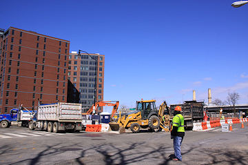
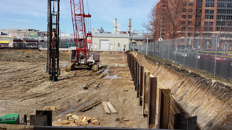
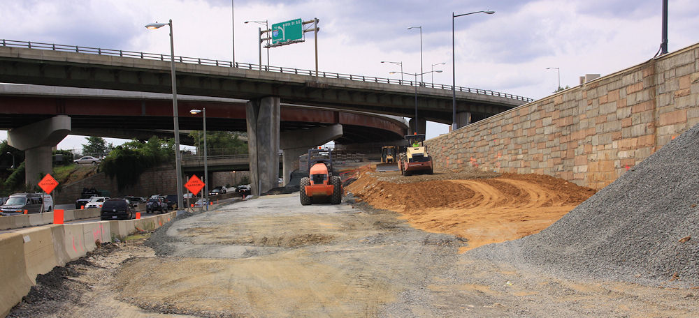
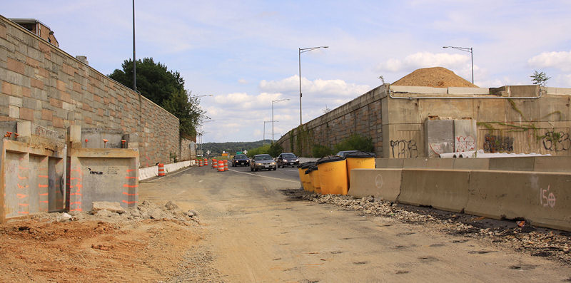
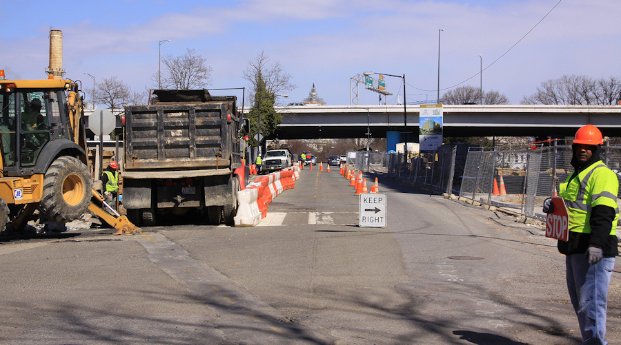 This morning broke clear and sunny, and with a full slate of photos on my agenda, I headed south down New Jersey Avenue from north of the freeway, snapping merrily along, until I came to the 82 I construction site on the northwest corner of New Jersey and I.
 With new sidewalks not yet in place in front of the Park Chelsea/800 New Jersey developments on the east side of the street, and with 82 I apparently not being covered under the regulations that resulted in the wide wide sidewalks you see all along the rest of the avenue, excavation and site work has been taking place right up to the (former) curb line on the only side of the street where pedestrians can walk. This has been going on for a few weeks, and while the temporary in-the-road-but-separated-by-plastic-barriers pedestrian path isn't optimal, it's also not unusual in these situations.
But this morning a large truck was parked in the former pedestrian path, with flagmen directing traffic in what had become just two very narrow north-south traffic lanes--and now there was absolutely nowhere for pedestrians to walk, in a location where it's very hard to take an alternate route on foot, unless you want to walk allllllll the way over to South Capitol and alllllll the way back to New Jersey once you get north of the freeway and train tracks, or backtrack southward to K so you can then walk north on 2nd or 3rd.
 I've sidestepped a lot (A LOT) of construction during my 12 years of JDLand-ing, and I am generally pretty laid back about it--I'm not walking a dog, or pushing a stroller, so I just kind of grumble and pick my way through.
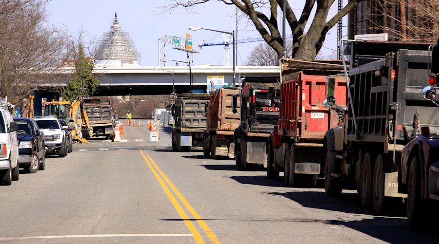
 But the situation this morning--when two flagmen on either end were each telling me a different lane in the street in which to walk, and later exacerbated by seeing the line of seven or more dump trucks that were idling back to and around onto K Street while waiting to haul off excavated dirt--well, it escalated past even my high bar of tolerance, especially since I know how many people now walk along New Jersey to go to Capitol South, or the Capitol complex, or wherever.
And with the Nats returning to the neighborhood one week from today, and with thoughts of the number of stadium-goers who also do that New Jersey Avenue walk before and after games, I did the normal thing in 2015--I mentioned the situation on Twitter.
Which led to a lot of other people speaking up on Twitter, many of whom have been complaining about the issues surrounding this construction since it began back in February. Before long, Ward 6 council member Charles Allen tweeted that he had contacted the director of DDOT, and that "he's looking into it."
 And while it shouldn't be the case that residents' complaints are ignored until either a) a loudmouth blogger fires off a tweet or b) baseball arrives, the truth is that the Nats' 2015 season is going to present a lot of challenges for anyone arriving in any way other than coming out of the Metro at Half and M.
 There will be less parking available this year (which I'll detail in an upcoming post), and with 13 active construction sites east of South Capitol between the freeway and Nats Park, cars and pedestrians and bikes and fans and residents and commuters will be fighting a lot of battles, even though for the most part there won't be at gametime the sort of active work that snarled New Jersey and I this morning.
In addition to this New Jersey Avenue construction possibly bedeviling fans using Capitol South, the blocking of the sidewalk on the west side of 1st Street south of M for Ballpark Square construction in the block just north of the stadium--and the apparent temporary loss of the bike lane there as well--will end up making lots of fans just walk in the street instead of crossing back to the east side of the street, away from the ballpark.
And there are other spots where sidewalks are now blocked off or narrowed, or where street parking is temporarily banned, which are the sorts of issues that lead to grumpy drivers and grumpy pedestrians, which can lead to bad things.
One hopes that there will be attention paid to ways to ensure a safer passage to the ballpark, but one also hopes that any real effort to mitigate these construction/sidewalk/traffic/pedestrian issues doesn't happen only during the hours that red-and-white-bedecked masses are around.
In the meantime, be careful out there, and not just right where you see construction. (I watched a dump truck blow through a red light at 1st and Potomac, taking me back to the last era of crazy amounts of construction, but that was in 2007 when the resident population was about 1/10th of what it is now.)
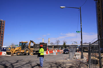
UPDATE: One thing I should have emphasized more clearly is that this was obviously a Saturday-type operation, where the assumption is that such a setup will be less disruptive than on a weekday, and so the contractor can then get more done (in this case, hauling of dirt) in a shorter timespan. This intersection is just a tough one, since, as I said above, it doesn't easily allow for alternate north/south passage if something is going on.
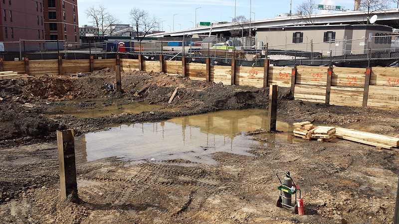
 UPDATE II: I went back on Sunday, where, as I expected, things were much quieter. And I also saw that part of the reason for the closure of the pedestrian walkway on Saturday was to build a new curb, and also pour some new concrete. I had noticed actually on Thursday that the old asphalt had a big crack in it and seemed to be dropping off toward the new excavation hole, so obviously this was a fix for that, and probably a pretty critical one.
 Note also at the bottom of the photo evidence of old cobblestone.
|
Comments (9)
More posts:
801nj, Pedestrian/Cycling Issues, Traffic Issues
|
* SOUTH CAPITOL SPEED CAMERAS: MPD has announced the latest batch of speed camera deployments, and it includes South Capitol Street between O Street and Potomac Avenue--alongside Nationals Park and just north of the Douglass Bridge--in both directions. "The 30 day educational phase, or 'warning period', will commence on or about March 23, 2015. During this period, violators will receive warning citations. After the 30 day warning period, MPD will begin issuing live moving citations to violators." * NATS PARK MAGNETOMETERS: There was a media event on Monday to unveil the new magnetometers at all entrances to Nats Park. (I'll note that this sign about the procedures will probably not be met with glee.) I wasn't at the event, but I did get my own shot on Sunday of the new installations at the Center Field Gate, as you see at right. The new security screening procedures will be in place starting with the April 4 exhibition game against the Yankees. Arrive early! (WaPo)
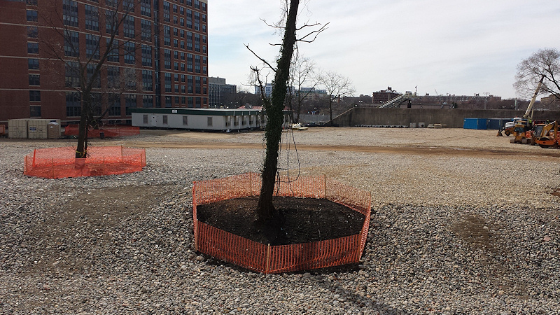 * PEEKING AT CSX: At right is a shot of the now-cleared area just south of the freeway and behind the 70 and 100 Capitol Yards apartment buildings. This work has had hearts aflutter that there could be some new development coming there, but it is actually just CSX clearing its considerable tract of land as prep work continues for the Virginia Avenue Tunnel.

* NATS PARK MAGNETOMETERS: There was a media event on Monday to unveil the new magnetometers at all entrances to Nats Park. (I'll note that this sign about the procedures will probably not be met with glee.) I wasn't at the event, but I did get my own shot on Sunday of the new installations at the Center Field Gate, as you see at right. The new security screening procedures will be in place starting with the April 4 exhibition game against the Yankees. Arrive early! (WaPo)* US-NY CIRCULATOR CHANGE: "From 3/29, catch the Union Station bus to Navy Yard only at Mass Ave and Columbus Cir 1st & 2nd St stops discontinued." (@DCCirculator; more here)
* YARDS PARK WORK: "We're almost ready for Splash Season! Please 'pardon our dust' as we prepare the water features and basin. We'll update here when finished!" (@YardsPark)
* PEEKING AT CSX: At right is a shot of the now-cleared area just south of the freeway and behind the 70 and 100 Capitol Yards apartment buildings. This work has had hearts aflutter that there could be some new development coming there, but it is actually just CSX clearing its considerable tract of land as prep work continues for the Virginia Avenue Tunnel. * PEEKING AT EVERYTHING ELSE: I'm going to have to recalibrate my normal mission to over-document projects in blog posts, given the breadth of work underway in the neighborhood. That said, I can't pass up a quick sharing of the cellphone photos I took Sunday afternoon while peeking through fences at the Homewood Suites, 82 I, Hampton Inn/Ballpark Square, and 909 Half sites. (Click all to enlarge.)
It would have been even better if I had included the other holes in the ground, at 1111 New Jersey, 800 New Jersey, and Florida Rock, but I failed.
|
Comments (6)
|
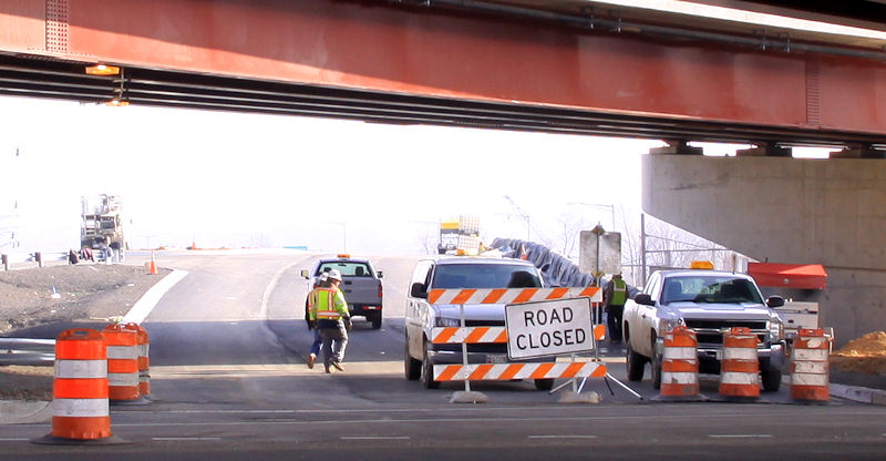
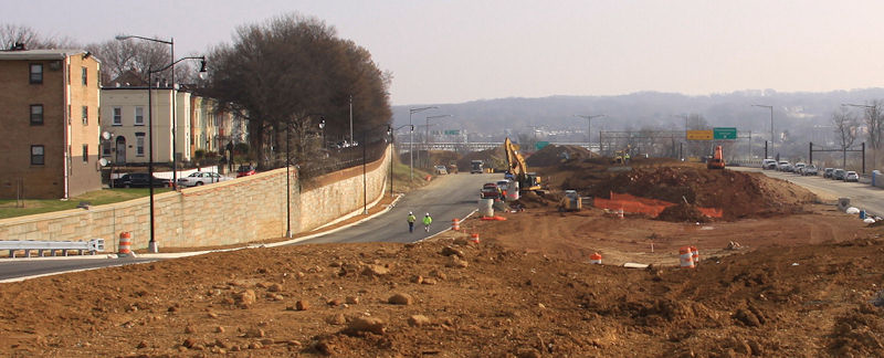
 It looks like the exit ramp to 8th Street SE from westbound I-695 (inbound from the 11th Street Bridges) that has been MIA in recent months may soon be back in business.
DDOT announced on Wednesday that it will be reducing I Street SE to one lane between 9th and 10th streets through the end of March so that they can "install a raised median island and accommodate the new free flow exit ramp connection currently under construction from westbound I-695 to 'Eye' Street, SE."
 This resulted in tasking my errand boy with some snowy photography, of not only the ramp itself (above), but also a hard-to-get shot of the new exit sign, surprisingly uncovered, on the freeway. You can see that the new exit goes underneath the no-longer-new ramp from 11th Street SE to the westbound freeway.
Also sayeth DDOT: "Upon completion of the construction, the street will be reopened in the final configuration with one lane westbound between 9th Street, SE, and 10th Street, SE. Modifications will also include improved safety features for pedestrians and the removal of rush-hour parking restrictions along this stretch."
The advisory did not give a date for the opening of the exit, which was closed nearly a year ago, at which point the scary flyover with the huge curve that led to the exit ramp was mercifully demolished.
|
Comments (1)
More posts:
11th Street Bridges, Traffic Issues
|
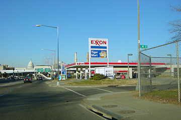
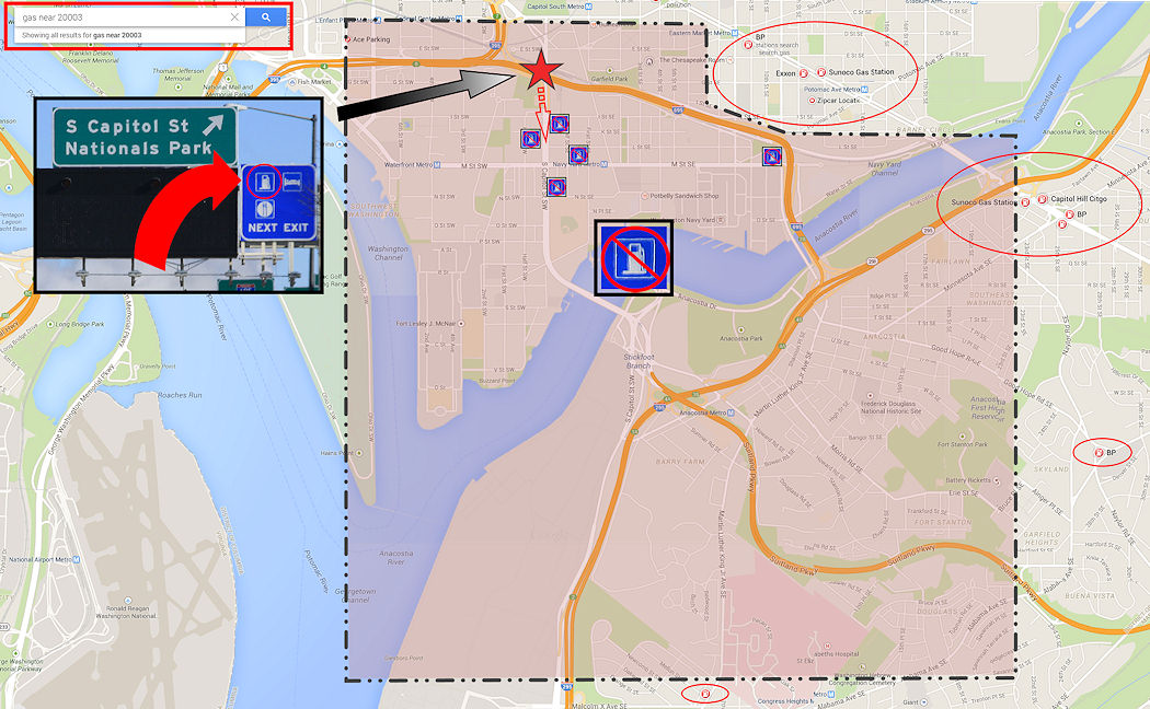 As you approach the South Capitol Street exit on the Southwest Freeway, there's a small blue sign overhead, dwarfed by its siblings and probably all but invisible to everyday users of the highway.
 It's a Gas - Food - Lodging sign, ubiquitous across this great land of ours and often a very (VERY) welcome sight, when the gas gauge has fallen below the Empty line and panic has begun setting in.
And while regulations generally say that an establishment can be located within three miles of the exit in order to allow for such a sign to be posted, in urban settings stressed low-fuel drivers have some level of expectation that when they get to the end of the ramp they will be greeted with at least one gas station within view, or a sign pointing where to go to find it and how far it will be.
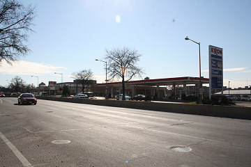
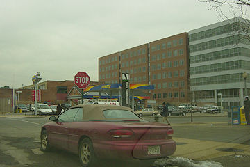
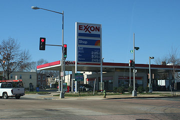
Up until about nine years ago, that's exactly what would happen when taking the South Capitol exit. There were Exxons on the east side of the street (at I) and the west side (at K). There was a BP Amoco station at N, plus a Sunoco at Half and M and another Exxon at 11th and M if one wanted to stray a little or a lot.
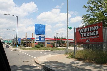 But then they started to close, and were all gone by 2008, though I will note that not a single one of those sites has been developed as of now.
So, if you are a desperate driver looking for gas, and you see that sign, and you start to head south on South Capitol Street, where is the first gas station you'd come across? You'd have to be smartphone-equipped to find your way 3.4 miles to the King Gas Station on Martin Luther King Jr. Avenue, just north of the intersection with Malcolm X Avenue.
But more likely you'd stay on the Suitland Parkway, and perhaps your Spidey Sense might then lead you north on Alabama Avenue to the BP at the intersection with Alabama, Naylor, and Good Hope Roads, 4.6 miles away from your exit.
Chances are though that you'd follow the Suitland Parkway until you are alerted otherwise. There's no signs as far as Google Street View shows for stations at Naylor Road (4.8 miles) and Silver Hill Road (6.3 miles), though the stations at the latter can probably be seen once you passed the exits, launching just the sort of in-car recriminations that end up being the highlight of so many car trips.
Eventually you end up at a T-intersection with Rt. 4/Pennsylvania Avenue, where if you are lucky--and clearly you aren't--you will guess that you should turn left, and be rewarded with a BP about a mile later, a total of 14.1 miles and God knows how many minutes since you exited the Southwest Freeway.
If instead you decide to keep heading forward in your same general direction, you could be all the way to the Sunoco in Lothian before you at last find your station, though of course you would totally have run out of gas somewhere during the 19.7-mile divorce-inducing trek.
The reality is that Pennsylvania Avenue SE is a frantic driver's best bet from the South Capitol Street exit, either by getting back on 695, heading across the 11th Street Bridge, and then going north on DC-295 to the Sunoco at the Pennsylvania Avenue interchange (2.7 miles), or by getting yourself north of the freeway and then taking a pick of the stations at 9th, 12th, or 13th (we're just going to ignore the Platinum-Coated Exxon at 4th and Pennsylvania), all of which are 1.5 miles-ish from the exit.
Residents figure these things out, so there's not the same scenario of needing gas, seeing a sign, and expecting a relatively simple path to a fill-up. And it's not exactly a news flash that gas stations are becoming increasingly scarce in the downtown core.
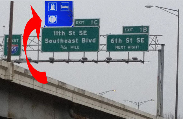 But maybe this poor blue sign could be moved to the spiffy newish 11th Street/Southeast Blvd. exit.
Ditto on all of this for the similar blue signs pointing drivers coming south out of the 3rd Street Tunnel to the South Capitol Street exit.
(And to think that this was originally just going to be nothing more than a snarky tweet of the photo of the blue sign!)
|
Comments (9)
More posts:
South Capitol St., Traffic Issues
|
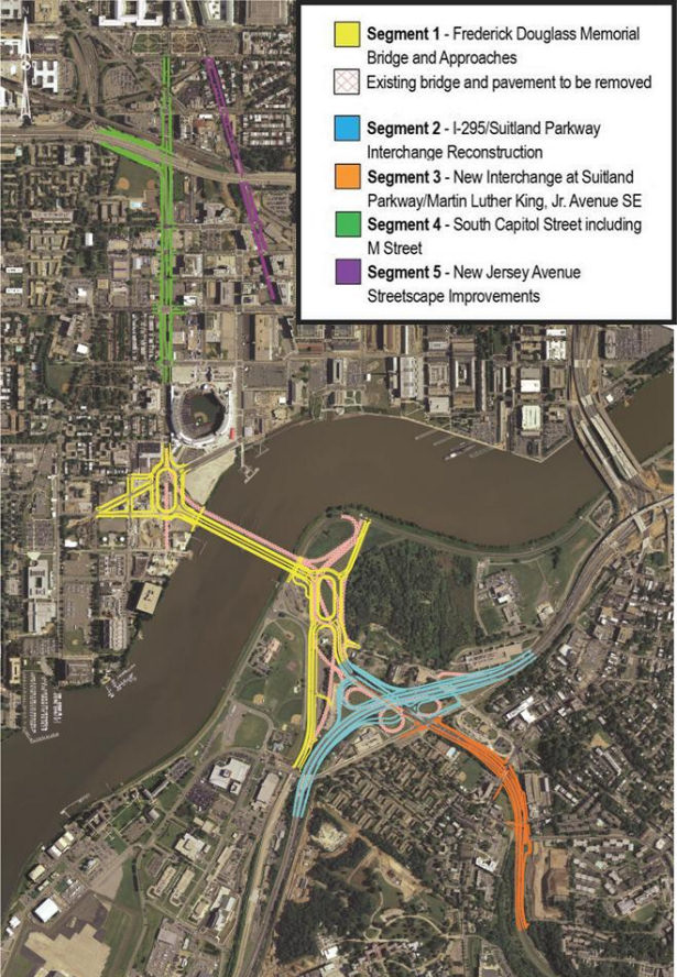
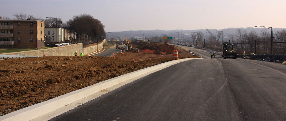
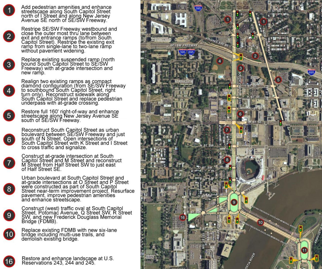 If you are looking for some light Christmas reading, you can sit down by the fireplace with all 335 pages (plus appendices!) of the newest revision to the plans for reconfiguring much of South Capitol Street, including the construction of a new Frederick Douglass Bridge.
This document, technically known as the Supplemental Draft Environmental Impact Statement (SDEIS), describes the new "revised preferred alternative" (RPA) design that tweaks the original preferred alternative in the Final EIS released back in 2011.
The bullet points for what the project plans are north/west of the Anacostia River are in the graphic at right (click to enlarge). The changes in this new RPA include:
* Changing the design of the bridge from a moveable span to a fixed-span bridge, which would save approximately $140 million in construction costs;
* Shifting the orientation of the new Douglass Bridge to an alignment parallel to the existing bridge, 30 feet down river, which avoids the need and lengthy process to acquire some land from Joint Base Anacostia-Bolling as well as a number of expensive relocation and reconstruction issues that a new alignment avoids (see page 2-91 of the SDEIS for details);
* A slight reduction of the size of the traffic oval on the western side (at Potomac Avenue):
* Replacing the previously designed circle on the eastern approach with an oval, located entirely in the DDOT right-of-way;
* And several other changes on the east side of the project that I will leave to others to discuss in detail. (See page ES-6 of the SDEIS.)
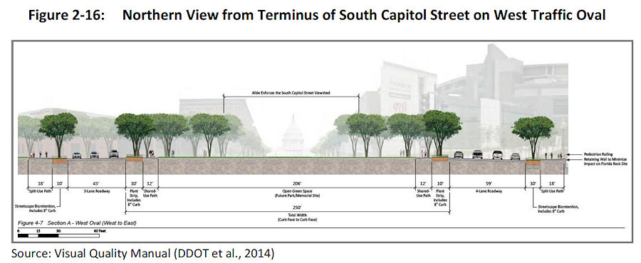 The initial design of the ovals and of the bridge itself were met with some consternation during this revision process. The SDEIS notes that in response to these concerns, DDOT has created a "Visual Quality Manual" for the project, which identifies design goals that are to "reflect the vision of providing a grand urban boulevard, which will be a gateway into the nation's capital, an iconic symbol of the District's aspirations in the 21st century, and a catalyst to revitalize local neighborhoods and the Anacostia Waterfront." (page 2-26).
  As for the bridge itself, the version in this RPA will support three travel lanes in each direction, along with 18 feet of bicycle and pedestrian paths on *both* sides of the bridge--an 8-foot lane for pedestrians and a 10-foot birdirectional bike path. (Enlarge the image at right to see that I'm not lying about the bike/ped stuff.)
And the design of the bridge is to "make its primary aesthetic impact through its position (alignment), and the shape and sizes of its structural elements" and is to " aesthetically appear to be part of a continuous urban corridor." This includes the avoidance of "using elements, solely for aesthetic effect, which do not contribute to the support of the bridge." (page 2-28)
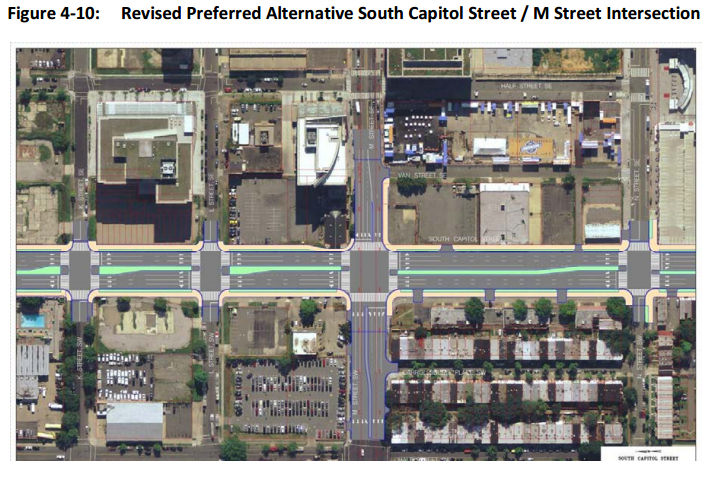
Plans for the reconfiguration of South Capitol Street as a "grand urban boulevard" have all along called for changing the intersection of South Capitol and M streets to an "at-grade intersection" (page 4-79), which would also mean that K and L would have signalized four-way intersections with South Capitol, unlike today. The wide median seen south of N would be established on the north end of the street as well, now all the way to D Street SE in the RPA. Also changing in this new plan are a few new left-turn options at I Street SE/SW and L Street SE.
 Revisions have also been made to the ramps from South Capitol Street to I-395 and I-695, but the basics from the original plans remain, most notably the demolition of the existing suspended ramp from northbound South Capitol to the SE/SW Freeway.
Even with the revisions made to cut the costs of the new Douglass Bridge, this isn't a cheap project. The five phases together are anticipated to cost over $1 billion, with Segment 1, including the new bridge and traffic ovals, estimated at $480 million. The "grand boulevard"-izing of South Capitol Street is estimated at $153 million, and planned streetscape improvements to New Jersey Avenue between D and M streets SE at $42 million, plus another $358 million in east-of-the-river improvements (page 2-11).
Worn out yet? I sure am! (I've mostly lost track of how much of this is truly even "new" news at this point.) But perhaps you can regain your strength by Jan. 22, 2015, when the public meeting on this SDEIS will be held from 6:30 to 8:30 pm at Matthews Memorial Baptist Church Fellowship Hall, 2616 Martin Luther King Ave., SE. The public comment period is running until Feb. 2. DDOT is also still amidst the design/build proposal process, with proposals expected sometime in the spring.
The SouthCapitolEIS.com web site is now focused mainly on this SDEIS, of which clearly I've just scratched the surface; you can slog through my piles of posts on all of this over the years for the historical rundown.
UPDATE: Here's the WashCycle take on the latest plans, from a bike/ped perspective.
|
Comments (5)
More posts:
Pedestrian/Cycling Issues, meetings, M Street, South Capitol St., Douglass Bridge, Traffic Issues
|
 DDOT announced that today (Dec. 22) they have opened Southeast Blvd. between 11th St. SE and Pennsylvania Avenue at Barney Circle.
Considering it looked like this nine days ago, the pedal must have been put to the metal.
Anyone want to report from there? I'll be interested to see how the signalized section at 11th Street handles the presumed new influx of east/west traffic.
The planning project to come up with concepts for how the road could look and function in the future continues.
UPDATE, 9:15 PM: Dark? Rainy? What a perfect time to try out a new road! I was coming home a little while ago on the SW/SE Freeway from Virginia, so decided to follow them there new signs for "Southeast Blvd."
I crossed 11th Street at the bottom of the exit ramp from the SE Freeway, then drove east on the new road to the light/merge at Pennsylvania Avenue just before the Sousa Bridge, where I'd still be sitting if I hadn't decided to finally run the light after waiting and waiting and waiting. (The stretch of road that continues eastward under Barney Circle is not reopened, though there is line striping for a lane to eventually head that way, it's just blocked off.)
Then, after a fun reversing of course that involved doubling back via DC-295 and two of the new ramps to and from 11th Street SE/MLK Blvd., I went westward on Pennsylvania Avenue and took the exit "To I-395." That goes under Barney Circle as it used to, and eventually I returned to 11th Street SE at the new signalized intersection where I could have chosen to go straight to get onto the westbound SE Freeway.
Impressions? Hard to tell in the rain. The MC Dean folks were out working on the signals, there's still a lot of cleanup work going on in the median, and a lot of heavy construction work is still in evidence on the eastern end by Barney Circle.
But if the city wants to rake in the dough, they'll set up speed cameras to enforce the SPEED LIMIT 30 signs that I LOL'ed at as I drove past them. Call it a "Boulevard" or call it a limited-access divided highway, but it is not a streetscape that screams 30 MPH.
(Photos will have to wait until the sun is actually out.)
UPDATE, 12/23: Via my very poorly paid stringer (Mr. JDLand), one shot of the now-uncovered signage for Southeast Blvd. eastbound on I-695/SE Freeway.
|
Comments (0)
More posts:
Southeast Blvd., Traffic Issues
|
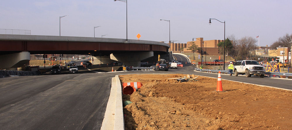
 I finally got my lazy self over to 11th Street with my camera this past weekend, and got quite the view of the soon-to-arrive Southeast Blvd., the reconstituted road between Barney Circle and 11th Street that runs along the path of the old sunken east end of the Southeast Freeway.
 A kind official, taking a wild guess at who that old lady shooting photos of construction might possibly be, guided me in for a quick peek over the crest of the hill, eastward toward Barney Circle:
The new road will be two lanes in each direction, separated by a fair amount of non-road area, as you can see. At the new signalized intersection with 11th Street, the lanes align with the new ramps to and from the Southeast Freeway. Here's what the approach to 11th Street looked like in 2012, when the freeway still ran beneath 11th, along with the similar-but-higher-up view now. (Click to enlarge, and use the massive freeway pylons and flyover to orient yourself, especially in terms of the vertical change.)
As I have written about previously, there has been a fair amount of consternation over this road, both in terms of what some people feel is a rush to get it reopened along with much unhappiness when DDOT unveiled its initial concepts for the road's long-term design. The Office of Planning has since been working on a new set of designs to better meet a goal of reintegrating this area with the surrounding neighborhood, and last week there was a public meeting to go over these concepts, seen below and laid out in detail in the presentation slides.
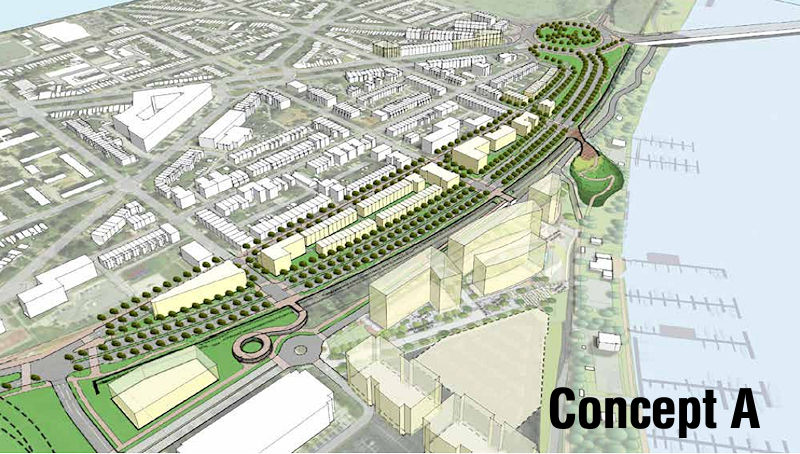
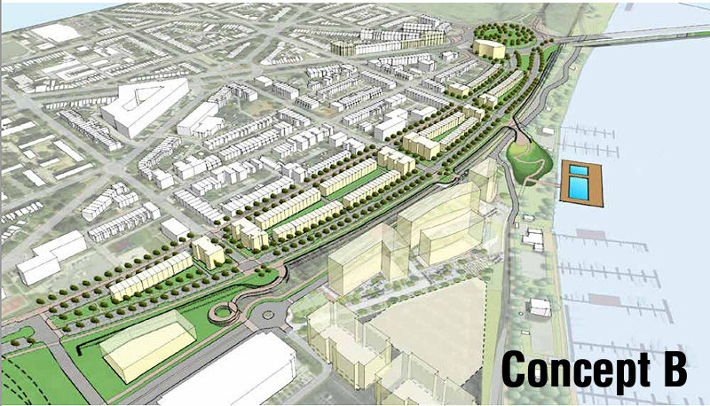
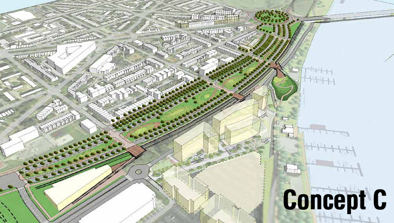
When comparing these concepts to the road about to open, you can see that the general layout of the traffic lanes and available space are the same, though Concept B has just one lane in each direction just one new two-lane boulevard heading eastward while A and C have two lanes in each direction (UPDATED to fix how B is characterized). (And bike lanes! There are bike lanes!) However, all three would build up the boulevard so that it would become level with L Street, and would then allow 13th, 14th, and 15th streets to intersect with the boulevard for both vehicular and pedestrian traffic.
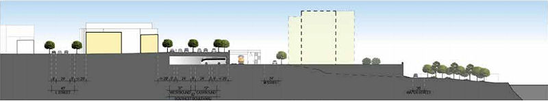 At right is a side view showing the proposed elevation for Concept A, running from L Street at left over to the train tracks and then down to the river.The CSX train tracks that run to the right of the road's footprints prevent further connection of these streets to M Street and the river, but there could be pedestrian bridges built to bring people across the tracks. (Note that all three concepts show the position of the planned 1333 M Street residential project just south of the boulevard.)
 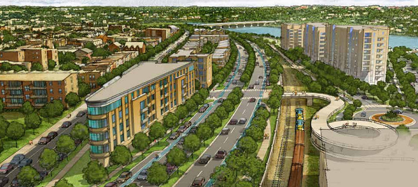 Two of the designs call for development within the huge median, either of low-rise multi-family buildings or townhouses or some combination thereof (at right is a rendering of the Concept A vision). The third design leaves it as a wide-open park space. And two of the three plans show the parking beneath the boulevard for buses that seems to be a requirement from DDOT's point of view.
I'm not going to go into great detail about what was said at the meeting--you can browse the presentation slides and read Capitol Hill Corner's report, which includes the many concerns of nearby residents, especially the ones who don't have much interest in connecting L, 13th, 14th, and 15th to this road.
At this stage, these truly are just concepts. There would next need to be a feasibility study/traffic flow analysis done by DDOT, an undertaking that has no timetable. There is also the issue of this land having been turned over to the city by the feds with the requirement that it be used for "transportation purposes," which raises questions about whether plopping residential buildings in the middle of it all would be an issue.
In the meantime, the new version of this road should open early in 2015.
Here's one more before-and-almost-after, looking eastward from down in the depths back in 2012 (left) and then an expanded version of the current view. Use the apartment building and retaining wall at left to orient. The embankment in the median in the "before" photo is the remnant of the ramps from the old 11th Street Bridges to and from RFK.
|
Comments (6)
More posts:
Southeast Blvd., Traffic Issues
|
 * M STREET CLOSURE: DDOT has put out the word that M Street SE between 8th and 11th will be closed on Saturday, Dec. 13 from 6 am to 9 pm, weather permitting, to complete final surface paving and striping between 10th and 11th.
 * CSX OUTREACH: There may be a lawsuit pending, but that hasn't stopped CSX from giving their Virginia Avenue Tunnel web site a big makeover, and also rebranding the existing Twitter account as @VATNews. The web site has all sorts of new sections and documents, though I would imagine Opinions Differ in some quarters about the contents.
* METRO PAYMENT PILOT: Navy Yard-Ballpark is one of the Metro stations that's part of WMATA's Payment Pilot program, testing out the "secure fare payment system of the future" that will allow the use of NFC-equipped credit cards and smartphones. So, if you've seen a shiny new fare gate being installed at the station lately, this is why. The program is expected to start in January, and you can still apply to be a tester
* BOATHOUSE EXPANSION: (Boats are transportation, right?) The Hill Rag reports that there are plans underway to renovate facilities along Boathouse Row, the stretch of marinas and buildings along the west side of the Anacostia between the 11th Street and Pennsylvania Avenue bridges. The Historic Anacostia Boating Association outlined for ANC 6B last month a proposed facility with a 228-slip marina, a pier for water taxis, and a boat ramp, along with other outdoor activity space. Fundraising is apparently now underway.
(And of course I'm sure you already read my post from yesterday about the Circulator's planned extension of the Navy Yard route into Southwest.)
|
Comments (1)
|
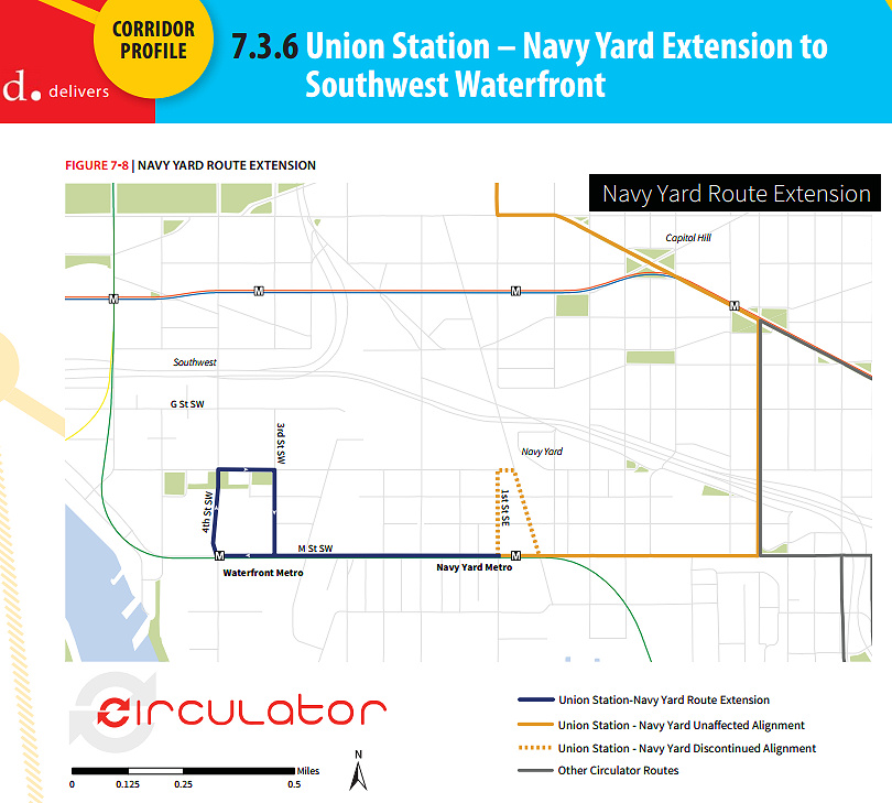 This week DDOT released its Final Circulator Development Plan, which among many other items calls for the extension of the Union Station-Navy Yard route along M Street to the Southwest Waterfront, sometime in the next two years, a plan that already has funding from the DC Council.
I asked about the timeframe for the new service, and DDOT informed me that it is proposed for the summer or early fall of 2015, pending the receipt of new buses, which have already been ordered and are expected to arrive in late spring or early summer.
Of the 1,041 people who took this year's survey, 44 percent identified the Southwest Waterfront as one of three top areas to which Circulator service should expand. This page from the report gives additional metrics on the proposed expanded route.
The plan also calls for a "Union Station-Navy Yard Schedule and Span Pilot Study," that would provide additional evening and weekend service to see if ridership demand and the increasing population around the Navy Yard Metro station supports making the changes long-term. DDOT tells me that this study is expected to begin in the first half of 2015. Currently the route runs until 7 pm weekdays in winter months, and 9 pm in the summer months along with Saturday service and extended evening/Sunday service for Nationals games.
 However, the report also recognizes that this line "in particular suffers from severe congestion around Union Station" and that DDOT is pursuing options to reroute this line.
One other nugget very deep in the 128-page report is that down the road, if and when the Convention Center/Southwest Waterfront line is reestablished, "additional analysis should be conducted to determine the potential of extending the Convention Center-Southwest route to the Navy Yard in lieu of extending the Union Station-Navy Yard route to Southwest."
Other service expansions on tap to appear between now and FY 2017 include the new National Mall route, a new National Cathedral-McPherson Square route, and three additional extensions: the Potomac Avenue-Skyline route to Congress Heights, the Union Station-Georgetown route to the Cathedral, and the Dupont-Georgetown-Rosslyn route to U Street and Howard University. In the distant future (FY2021-FY2024) there could possibly be a Dupont-Southwest Waterfront route.
Read the full plan for more detail than you probably ever wanted about the service and the expansion plans across the city, or just scan the Executive Summary if you're lazy. And if you want to receive updates without having to wait for me to get around to telling you, you can sign up for the DC Circulator Newsletter.
|
Comments (7)
More posts:
circulator, Traffic Issues
|
 A community meeting is on tap for Thursday (tomorrow), Dec. 11, to discuss the future Southeast Blvd., specifically the ideas emerging from the neighborhood study currently being spearheaded by ANC 6B, the Office of Planning, and DDOT.
The meeting is from 7 to 9 pm at Friendship Chamberlain Elementary School, 1345 Potomac Ave., SE, across from the Jenkins Row Harris Teeter.
Councilmember Tommy Wells will be there, and will be part of the discussion on how to best integrate into the neighborhood this road that will run from Barney Circle to the new intersection at 11th Street, SE, along the path of the old sunken portion of the Southeast Freeway.
A "temporary" version of the road is opening in early 2015, and residents have been concerned both about this becoming the de facto new version of the road, a feeling that came on the heels of the original new designs put forth by DDOT, that were basically replacing an old freeway with a new freeway, albeit it one that has a stoplight at 11th Street rather than just a free-and-clear approach to the Southeast Freeway. After those designs were released, with a push from Wells, the Office of Planning stepped in to help shepherd a neighborhood study--initial design concepts were unveiled back in August, and this week's meeting is to continue the process of refining the possibilities.
(And I am well aware that I have completely failed at keeping up with photographs of that area of 11th and of the work underway on the temporary road. All of the construction there, and the futzing with the traffic flow configuration of 11th Street while work continues around it, have made me very cranky about going over there to take pictures. Maybe this will finally spur me.)
|
Comments (4)
More posts:
meetings, Southeast Blvd., Traffic Issues
|
251 Posts:
Go to Page: 1 | 2 | 3 | 4 | 5 | 6 | 7 | 8 | 9 | 10 ... 26
Search JDLand Blog Posts by Date or Category
Go to Page: 1 | 2 | 3 | 4 | 5 | 6 | 7 | 8 | 9 | 10 ... 26
Search JDLand Blog Posts by Date or Category