
|
| |||||||||||||||||||

|
Please note that JDLand is no longer being updated.
peek >>
Near Southeast DC Past News Items: Traffic Issues
- Full Neighborhood Development MapThere's a lot more than just the projects listed here. See the complete map of completed, underway, and proposed projects all across the neighborhood.
- What's New This YearA quick look at what's arrived or been announced since the end of the 2018 baseball season.
- Food Options, Now and Coming SoonThere's now plenty of food options in the neighborhood. Click to see what's here, and what's coming.
![-]()
- Anacostia RiverwalkA bridge between Teague and Yards Parks is part of the planned 20-mile Anacostia Riverwalk multi-use trail along the east and west banks of the Anacostia River.
![-]()
- Virginia Ave. Tunnel ExpansionConstruction underway in 2015 to expand the 106-year-old tunnel to allow for a second track and double-height cars. Expected completion 2018.
![-]()
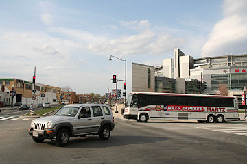
- Rail and Bus Times
Get real time data for the Navy Yard subway, Circulator, Bikeshare, and bus lines, plus additional transit information. - Rail and Bus Times
Get real time data for the Navy Yard subway, Circulator, Bikeshare, and bus lines, plus additional transit information. - Canal ParkThree-block park on the site of the old Washington Canal. Construction begun in spring 2011, opened Nov. 16, 2012.
![-]()
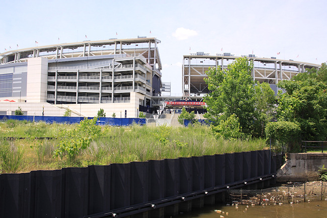
- Nationals Park21-acre site, 41,000-seat ballpark, construction begun May 2006, Opening Day March 30, 2008.
![-]()
- Washington Navy YardHeadquarters of the Naval District Washington, established in 1799.
![-]()
- Yards Park5.5-acre park on the banks of the Anacostia. First phase completed September 2010.
![-]()
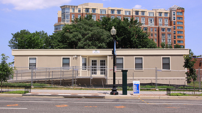
- Van Ness Elementary SchoolDC Public School, closed in 2006, but reopening in stages beginning in 2015.
![-]()
- Agora/Whole Foods336-unit apartment building at 800 New Jersey Ave., SE. Construction begun June 2014, move-ins underway early 2018. Whole Foods expected to open in late 2018.
![-]()
- New Douglass BridgeConstruction underway in early 2018 on the replacement for the current South Capitol Street Bridge. Completion expected in 2021.
![-]()
- 1221 Van290-unit residential building with 26,000 sf retail. Underway late 2015, completed early 2018.

- NAB HQ/AvidianNew headquarters for National Association of Broadcasters, along with a 163-unit condo building. Construction underway early 2017.

- Yards/Parcel O Residential ProjectsThe Bower, a 138-unit condo building by PN Hoffman, and The Guild, a 190-unit rental building by Forest City on the southeast corner of 4th and Tingey. Underway fall 2016, delivery 2018.

- New DC Water HQA wrap-around six-story addition to the existing O Street Pumping Station. Construction underway in 2016, with completion in 2018.

- The Harlow/Square 769N AptsMixed-income rental building with 176 units, including 36 public housing units. Underway early 2017, delivery 2019.

- West Half Residential420-unit project with 65,000 sf retail. Construction underway spring 2017.
![-]()
- Novel South Capitol/2 I St.530ish-unit apartment building in two phases, on old McDonald's site. Construction underway early 2017, completed summer 2019.
![Novel South Capitol]()
- 1250 Half/Envy310 rental units at 1250, 123 condos at Envy, 60,000 square feet of retail. Underway spring 2017.
![-]()
- Parc Riverside Phase II314ish-unit residential building at 1010 Half St., SE, by Toll Bros. Construction underway summer 2017.
![-]()
- 99 M StreetA 224,000-square-foot office building by Skanska for the corner of 1st and M. Underway fall 2015, substantially complete summer 2018. Circa and an unnamed sibling restaurant announced tenants.
![-]()
- The Garrett375-unit rental building at 2nd and I with 13,000 sq ft retail. Construction underway late fall 2017.
![-]()
- Yards/The Estate Apts. and Thompson Hotel270-unit rental building and 227-room Thompson Hotel, with 20,000 sq ft retail total. Construction underway fall 2017.
![-]()
- Meridian on First275-unit residential building, by Paradigm. Construction underway early 2018.
![-]()
- The Maren/71 Potomac264-unit residential building with 12,500 sq ft retail, underway spring 2018. Phase 2 of RiverFront on the Anacostia development.
![-]()
- DC Crossing/Square 696Block bought in 2016 by Tishman Speyer, with plans for 800 apartment units and 44,000 square feet of retail in two phases. Digging underway April 2018.
![DC Crossing]()
- One Hill South Phase 2300ish-unit unnamed sibling building at South Capitol and I. Work underway summer 2018.
![One Hill South Phase 2]()
- New DDOT HQ/250 MNew headquarters for the District Department of Transportation. Underway early 2019.
![New DDOT HQ]()
- 37 L Street Condos11-story, 74-unit condo building west of Half St. Underway early 2019.
![37 L Condos]()
- CSX East Residential/Hotel225ish-unit AC Marriott and two residential buildings planned. Digging underway late summer 2019.
![CSX East Residential/Hotel]()
- 1000 South Capitol Residential224-unit apartment building by Lerner. Underway fall 2019.
![1000 South Capitol Residential]()
- Capper Seniors 2.0Reconstruction of the 160-unit building for low-income seniors that was destroyed by fire in 2018.
![1000 South Capitol Residential]()
- Chemonics HQNew 285,000-sq-ft office building with 14,000 sq ft of retail. Expected delivery 2021.
![1000 South Capitol Residential]()


251 Blog Posts Since 2003
Go to Page: 1 | 2 | 3 | 4 | 5 | 6 | 7 | 8 | 9 | 10 ... 26
Search JDLand Blog Posts by Date or Category
Go to Page: 1 | 2 | 3 | 4 | 5 | 6 | 7 | 8 | 9 | 10 ... 26
Search JDLand Blog Posts by Date or Category
 I'm not sure how many people made this afternoon's meeting on the SE/SW Transportation Improvement Study (I sure didn't thanks to that 4 pm start time), but apparently there is a web site devoted to the project, and the meeting materials are posted there: seswdc.com.
This study is actually an Environmental Assessment, meaning there are very specific structures and steps that DDOT will be following.
Its stated purpose is "to develop a premium transit system that improves transportation capacity, connectivity, mobility, and safety through an integrated, multimodal transportation corridor" across Near Southeast, Southwest, and the Anacostia Historic District.
Also, the study is to address "east-west transportation needs between the Southeast and Southwest Washington communities of Anacostia and the Waterfront."
 One tidbit in the materials that may be news to people: If streetcars are chosen as the area's "premium transit mode," there will be a need for storage and/or maintenance, and so this Environmental Assessment "will review and analyze potential sites for a Streetcar facility."
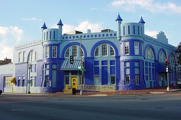
 Eight potential sites meeting the initial minimum requirements have been identified: three near M Street, SW, three at Buzzard Point, and two along 7th Street, SE, including, believe it or not, the Blue Castle, aka the Navy Yard Car Barn, where streetcars were stored and maintained during the many years they ran through the city before being shut down in the early 1960s.
A second public meeting is expected in early 2015, with the draft Environmental Assessment and associated public hearing in spring and the final document late in the year.
(Thanks to Josh Hart for the heads up about the web site, and no thanks to DDOT, who didn't mention it in their releases about the meeting. BAH!)
|
Comments (14)
More posts:
Pedestrian/Cycling Issues, meetings, Traffic Issues
|
 From DDOT: On Wednesday, Oct. 22, DDOT and the Federal Highway Administration will be holding a public meeting to discuss the Southeast/Southwest Transportation Improvement Study and Environmental Assessment, which is actually now a formal NEPA study (hence the presence of FHWA).
 Officially, "The purpose of the study is to develop a premium transit system that improves transportation capacity, connectivity, mobility, and safety."
This is an off-shoot of the first M Street SE/SW study from 2011 and 2012 as well as the subsequent Special Events transportation study that was completed earlier this year. In other words, the study after the study after the study.
The meeting will be held at at Van Ness Elementary at 4 pm (! - I asked if that was a typo, and was told no). DDOT's announcement of the meeting says that "the public will be provided an opportunity to discuss the transportation issues and potential solutions that will be addressed in the study."
 ANC 6B commissioners Brian Flahaven and Kirsten Oldenburg have both written about a new batch of design concepts for Southeast Blvd., the planned stretch of road between 11th Street SE and Barney Circle where the sunken far eastern portion of the Southeast Freeway used to run.
Almost a year ago, DDOT presented five designs for the new road that basically, as Flahaven puts it, "replaced the freeway with ... a freeway completely separated from the neighborhood grid." The designs were not well received, and with a push from councilmember Tommy Wells, the Office of Planning stepped in to conduct a "rapid response" study of the neighborhood and the project. And on Aug. 4, these new designs were unveiled at a public meeting.
The boards show both two-lane and four-lane designs for the road, some with direct access to the Anacostia Waterfront and extension of the street grid to the boulevard, some without. The Office of Planning now plans to take community feedback--which apparently was considerably more positive this time around--and move forward with three final concepts that can be presented to the community and to DDOT this fall.
However, it also turns out that DDOT is planning to go ahead and reopen this stretch of road by the end of the year, with the traffic flowing through the new signalized intersection on 11th Street SE where the exit ramp from the Southeast Freeway recently opened. Oldenburg describes what she see as the "major implications" of this move: "First, this freeway segment becomes the No Build option in the study. Second, in my view, it will take the pressure off city officials to get the NEPA study completed in a timely manner, hopefully, incorporating some of the fresh ideas generated by the OP study."
Flahaven is urging residents to contact Mayor Gray and council members with their thoughts on this.
|
Comments (11)
More posts:
Southeast Blvd., Traffic Issues
|
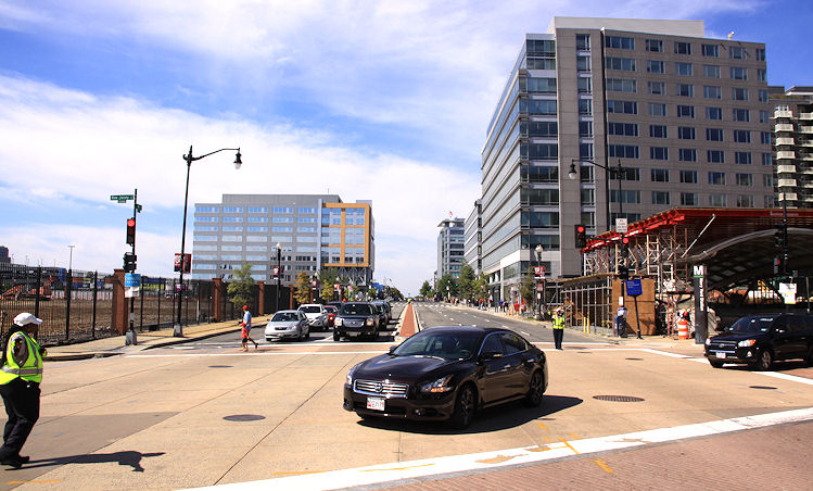
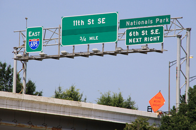
Despite it being four weeks after the fact, JDLand's strict operating requirements still dictate that I document the new exit ramp to 11th Street SE from eastbound I-695. 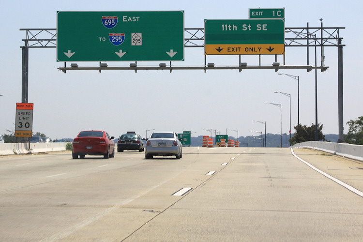 The view driving east on the Southeast Freeway (which is now I-695, if you haven't gotten the memo). If you always get off at or before the 6th Street SE exit, this may be an unfamiliar vista to you. The left lanes head toward the outbound 11th Street Bridges, while the right two lanes are the new movement that didn't exist before this whole project got underway. (And is that hidden part of the 11th Street sign maybe an eventual pointer to Southeast Blvd.?)
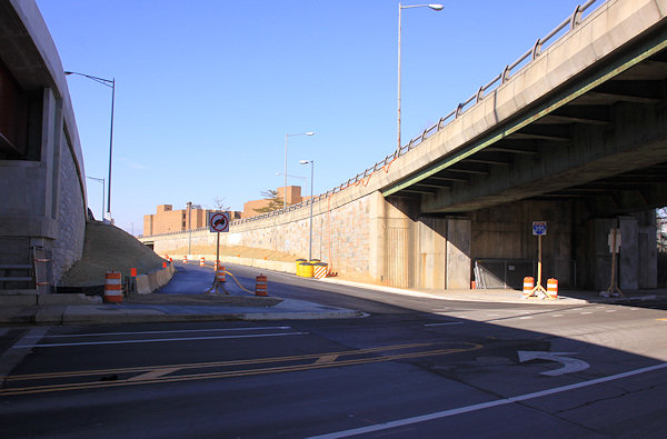
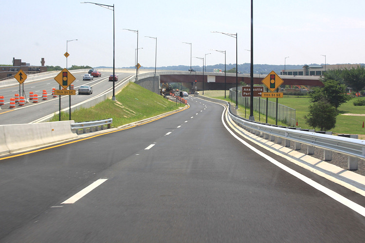 Behold, the new ramp! You also get to see the two new flyovers at left that have been built as part of this project, which has been underway since 2009. Sneaking up in between is the new on-ramp from 8th Street SE, which opened not long ago. At right is Virginia Avenue Park. Note also the sign pointing toward Anacostia Park--this would take you down 11th to the new local bridge and to the park that-a-way.
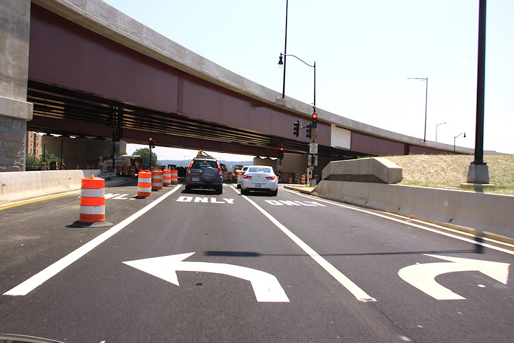 And now you come to the intersection at 11th. Turning left takes you north toward Pennsylvania Avenue and Lincoln Park, while turning right takes you to M Street, the Navy Yard, and the local bridge. Note the blocked-off third lane that is striped for left turns as well--I assume there will come a time when the middle lane will be for traffic continuing straight on Southeast Blvd.
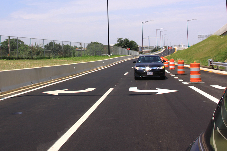 Wrapping up our little journey, here's a quick look backward at the road just traveled.
With thanks to Mr. JDLand for chauffeuring, here's what it's like to venture along this new route, if you haven't done it. (And sure, I could have Vined it, or YouTubed it, or whatever, but what fun would that be?)
The view driving east on the Southeast Freeway (which is now I-695, if you haven't gotten the memo). If you always get off at or before the 6th Street SE exit, this may be an unfamiliar vista to you. The left lanes head toward the outbound 11th Street Bridges, while the right two lanes are the new movement that didn't exist before this whole project got underway. (And is that hidden part of the 11th Street sign maybe an eventual pointer to Southeast Blvd.?)Behold, the new ramp! You also get to see the two new flyovers at left that have been built as part of this project, which has been underway since 2009. Sneaking up in between is the new on-ramp from 8th Street SE, which opened not long ago. At right is Virginia Avenue Park. Note also the sign pointing toward Anacostia Park--this would take you down 11th to the new local bridge and to the park that-a-way.And now you come to the intersection at 11th. Turning left takes you north toward Pennsylvania Avenue and Lincoln Park, while turning right takes you to M Street, the Navy Yard, and the local bridge. Note the blocked-off third lane that is striped for left turns as well--I assume there will come a time when the middle lane will be for traffic continuing straight on Southeast Blvd. Wrapping up our little journey, here's a quick look backward at the road just traveled. Need a reminder of what this spot used to look like? Remember the phrase "sunken freeway"? Here's a reminder, from street level and from above.


And, because I am a complete nutcase (which we already knew), here is a bunch of photos--strung together as a slideshow--that I took just as the 11th Street Bridges project was getting underway in early 2010, showing what it used to be like to drive across the Anacostia on that route. Apologies for the dirty windshield.
(I know, my archive just gets more and more alarming.)
|
Comments (2)
More posts:
11th Street Bridges, Southeast Blvd., Traffic Issues
|
First off, you may have noticed that Saturday was a lovely day. The neighborhood's waterfront was most definitely in use: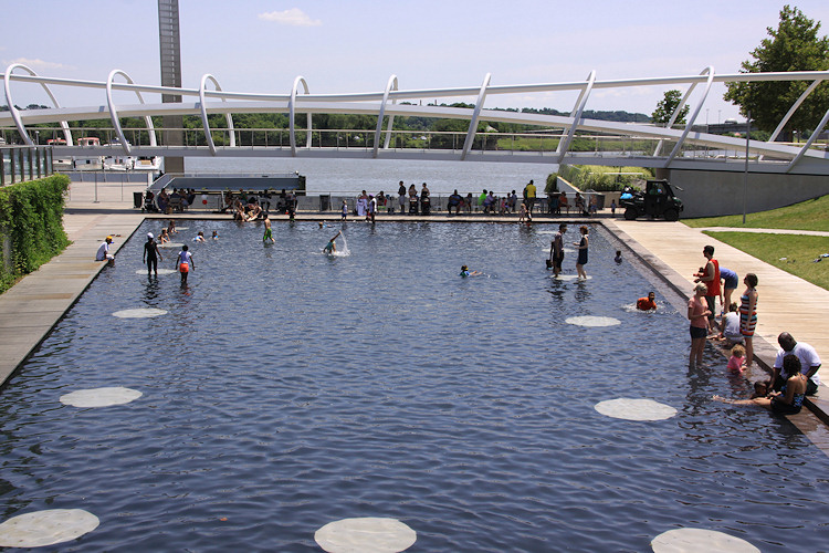
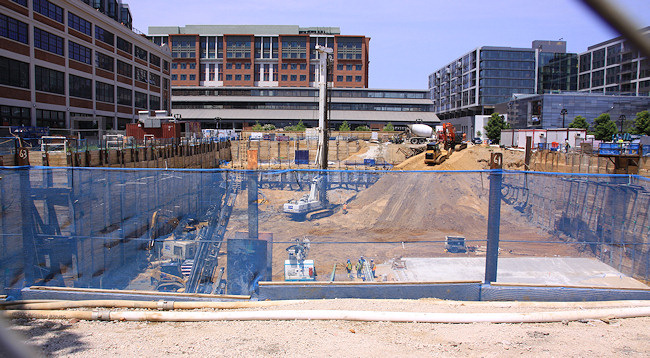
Not far away, at the Yards' Parcel N, concrete has appeared in the large hole in the ground (left), meaning that the digging down is almost over, and the rising up should start before too long (its tower crane permit application was approved not too long ago). And in a totally different illustration of progress (right), the sales-trailer-to-be for the River Parc apartment project appears to now be in its proper place.
(I wanted to get a photograph of the outdoor patio signage at the soon-to-arrive Ice Cream Jubilee at the Lumber Shed, but the hordes standing in line on Saturday to get into the Jazz Fest completely blocked the view.)
I recorded the current state of the Florida Rock site across from the ballpark {insert Logan's Run reference here}, because the developers have now filed applications for both sheeting and building permits for the site's first-phase apartment building. This doesn't necessarily mean the project is close to getting started, but it deprives me of my snarky "they haven't even applied for their permits yet" response whenever someone mentions that it might get underway soon.
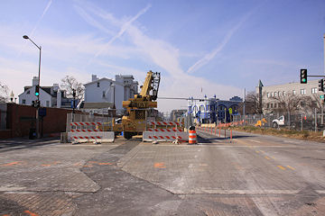
Finally, I present to you official evidence of the new 11th Street SE exit from the freeway, which I'm doing mainly as a mea culpa for not having gotten over there to photograph the ramp and environs, and to hopefully shame myself into action.
I also deserve additional shaming, or at least parallel shaming, for not yet documenting that the Southeast Freeway signage I have griped about for years has been fixed.
|
Comments (3)
|
 I already wrote about how this Saturday, June 21, is the target date for DDOT to open the new ramp from eastbound I-695 to 11th Street, SE. (Yay!)
But now there's a related closing to note: On June 21, DDOT will close the newish on-ramp from 11th Street SE to the westbound Southeast Freeway for two months, until approximately August 23.
This will allow the completion of the rebuilt exit to I Street from inbound I-695, which has been closed while the old flyover has been demolished.
If you're needing to get on the westbound freeway, you'll need to use the ramp at 3rd Street and Virginia Avenue, or the South Capitol Street ramp. (Or I guess you could go backwards and get on southbound DC-295 at Pennsylvania Avenue and take the Capitol Hill exit.)
Here's DDOT's advisory on that closing if you want to know more, or to see the pretty graphic with all the detour arrows.
 Meanwhile, the icky configuration of the eastern section of M Street thanks to DC Water's Clean Rivers Project is about to get ickier: Starting on or about Wednesday, June 18, through the end of the year, two eastbound M Street lanes between 7th and 11th Streets, SE will be closed 24/7, leaving two lanes of eastbound and two lanes of westbound traffic on M. Best to also expect some stoppages of traffic during the work hours of 7 am to 7 pm Monday through Saturday.
You can read the DC Water advisory on the closure for more information.
|
Comments (3)
More posts:
11th Street Bridges, M Street, Traffic Issues
|
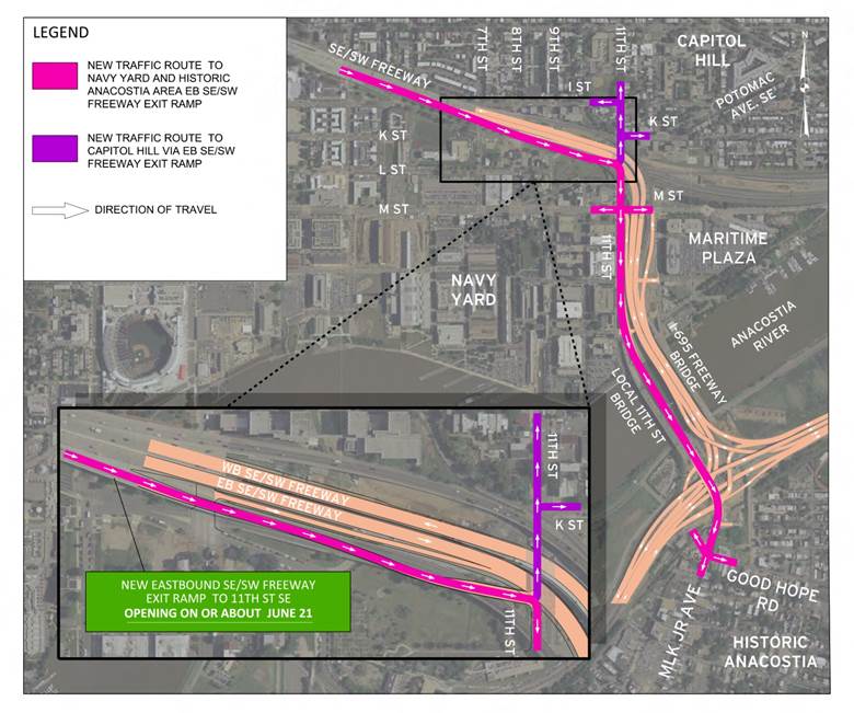 The next step in the 11th Bridges project is coming on or about June 21, when the new ramp down to 11th Street SE from the eastbound Southeast Freeway is scheduled to open.
This means that folks on the eastern end of Capitol Hill will no longer have to get off at 6th Street and wind their way eastward--they will arrive at 11th just north of L, and can either turn left on 11th or right to the Navy Yard and across the 11th Street Local bridge to Anacostia.
The map at right provided by DDOT shows the various new movements that this new ramp will put on the table.
Coupled with the entrance ramp to the westbound freeway that opened a while back, 11th Street is now quite the access point for the Southeast/Southwest Freeway. And someday, it will be a full intersection that will include traffic traveling to or from Southeast Blvd., in whatever form that ends up taking.
|
Comments (4)
More posts:
11th Street Bridges, Traffic Issues
|
 Long weekends mess with the mind.
* CRUISING BY THE HOOD: The Near Southeast Community Partners group, in concert with the 11th Street Bridge Park Project, Living Classrooms, and Anacostia Riverkeeper, are having a "Community Vision Cruise" along the Anacostia River on June 16 from 6 to 8 pm. Cruisers will ride the river on a 1928 boat and learn about the bridge park and programs to clean up the river, with food provided by Agua 301 and Ice Cream Jubilee. Tickets are $60 (and can bepurchased online), but note that space is limited.
* LOOKING AT THE HOOD: Urban Turf surveys the current state of the neighborhood, after the "rain delay" of the 2008-2012 time frame: "Now, Capitol Riverfront is seeing long-planned projects come to fruition, parks, restaurants and retailers are drawing visitors from across the city, and the streets no longer resemble a ghost town."
* FATTENING UP THE HOOD: The Tour de Fat is this Saturday at Yards Park, so get your bike and your liver tuned up.
* CROWDING IN THE HOOD: DDOT recently released the M Street Southeast/Southwest Special Events Study final report, which looks at the traffic impact along M Street of a number of potential entertainment venues, including of course Nats Park but also the potential new soccer stadium at Buzzard Point, all the attractions to come at the Wharf, and the movie theater eventually coming to the DC Water site. (The entire report is an 81 MB PDF, so get a cup of coffee.)
|
Comments (7)
|
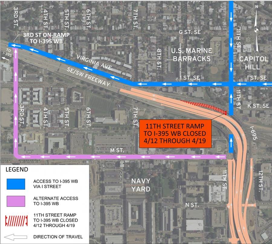 The newish, somewhat hidden ramp from 11th Street to the westbound Southeast Freeway is going to be closed from Saturday, April 12, through Saturday, April 19, "to allow construction crews to continue the demolition of the existing inbound bridge," according to DDOT.
 Drivers will be detoured to the long trek down I Street/Virginia Avenue to the ramp at 3rd Street, SE, as the latest arrow-filed map from DDOT shows. (So be careful at the 3rd and Virginia intersection, which might get a bit hairy.)
|
Comments (0)
More posts:
11th Street Bridges, Traffic Issues
|
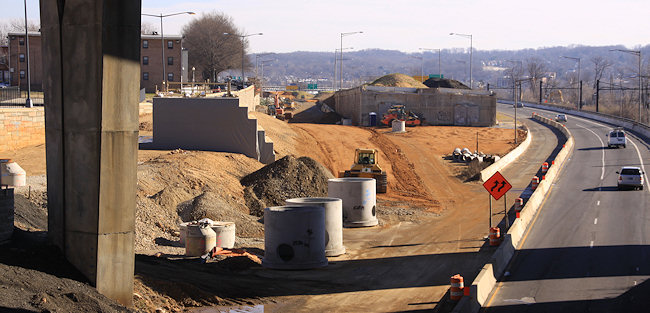
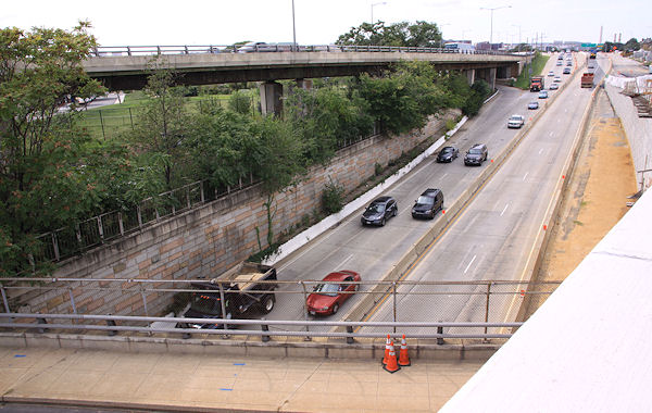
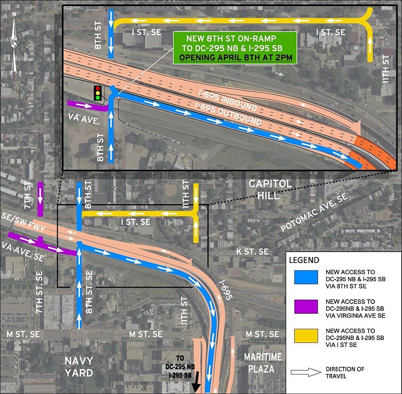
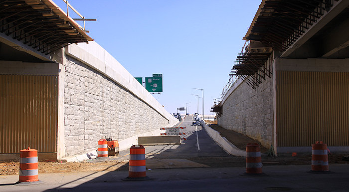 DDOT has just put out word that the "new" on ramp to outbound I-695 (i.e., the Southeast Freeway to the 11th Street Bridge) will be opening "on or about" tomorrow, April 8.
 "The opening of the new ramp provides a direct connection from Capitol Hill and the Navy Yard/Barracks Row area to northbound DC 295 and southbound I-295 via 8th Street SE."
This ramp, while technically new, is really just the replacement of the old ramp at 8th and Virginia, albeit now shifted a few yards to the north on 8th. My photo above, from a few weeks ago, shows the new ramp, with the outbound freeway lanes to the left, and at right, the under-construction ramp that will bring traffic from the freeway down to the new signalized interchange at 11th Street.
DDOT has also provided a spiffy map for the new ramp, showing all sorts of arrows.
|
Comments (12)
More posts:
11th Street Bridges, Traffic Issues
|
251 Posts:
Go to Page: 1 | 2 | 3 | 4 | 5 | 6 | 7 | 8 | 9 | 10 ... 26
Search JDLand Blog Posts by Date or Category
Go to Page: 1 | 2 | 3 | 4 | 5 | 6 | 7 | 8 | 9 | 10 ... 26
Search JDLand Blog Posts by Date or Category