
|
| |||||||||||||||||||

|
Please note that JDLand is no longer being updated.
peek >>
Near Southeast DC Past News Items: Traffic Issues
- Full Neighborhood Development MapThere's a lot more than just the projects listed here. See the complete map of completed, underway, and proposed projects all across the neighborhood.
- What's New This YearA quick look at what's arrived or been announced since the end of the 2018 baseball season.
- Food Options, Now and Coming SoonThere's now plenty of food options in the neighborhood. Click to see what's here, and what's coming.
![-]()
- Anacostia RiverwalkA bridge between Teague and Yards Parks is part of the planned 20-mile Anacostia Riverwalk multi-use trail along the east and west banks of the Anacostia River.
![-]()
- Virginia Ave. Tunnel ExpansionConstruction underway in 2015 to expand the 106-year-old tunnel to allow for a second track and double-height cars. Expected completion 2018.
![-]()
- Rail and Bus Times
Get real time data for the Navy Yard subway, Circulator, Bikeshare, and bus lines, plus additional transit information. - Rail and Bus Times
Get real time data for the Navy Yard subway, Circulator, Bikeshare, and bus lines, plus additional transit information. - Canal ParkThree-block park on the site of the old Washington Canal. Construction begun in spring 2011, opened Nov. 16, 2012.
![-]()
- Nationals Park21-acre site, 41,000-seat ballpark, construction begun May 2006, Opening Day March 30, 2008.
![-]()
- Washington Navy YardHeadquarters of the Naval District Washington, established in 1799.
![-]()
- Yards Park5.5-acre park on the banks of the Anacostia. First phase completed September 2010.
![-]()
- Van Ness Elementary SchoolDC Public School, closed in 2006, but reopening in stages beginning in 2015.
![-]()
- Agora/Whole Foods336-unit apartment building at 800 New Jersey Ave., SE. Construction begun June 2014, move-ins underway early 2018. Whole Foods expected to open in late 2018.
![-]()
- New Douglass BridgeConstruction underway in early 2018 on the replacement for the current South Capitol Street Bridge. Completion expected in 2021.
![-]()
- 1221 Van290-unit residential building with 26,000 sf retail. Underway late 2015, completed early 2018.

- NAB HQ/AvidianNew headquarters for National Association of Broadcasters, along with a 163-unit condo building. Construction underway early 2017.

- Yards/Parcel O Residential ProjectsThe Bower, a 138-unit condo building by PN Hoffman, and The Guild, a 190-unit rental building by Forest City on the southeast corner of 4th and Tingey. Underway fall 2016, delivery 2018.

- New DC Water HQA wrap-around six-story addition to the existing O Street Pumping Station. Construction underway in 2016, with completion in 2018.

- The Harlow/Square 769N AptsMixed-income rental building with 176 units, including 36 public housing units. Underway early 2017, delivery 2019.

- West Half Residential420-unit project with 65,000 sf retail. Construction underway spring 2017.
![-]()
- Novel South Capitol/2 I St.530ish-unit apartment building in two phases, on old McDonald's site. Construction underway early 2017, completed summer 2019.
![Novel South Capitol]()
- 1250 Half/Envy310 rental units at 1250, 123 condos at Envy, 60,000 square feet of retail. Underway spring 2017.
![-]()
- Parc Riverside Phase II314ish-unit residential building at 1010 Half St., SE, by Toll Bros. Construction underway summer 2017.
![-]()
- 99 M StreetA 224,000-square-foot office building by Skanska for the corner of 1st and M. Underway fall 2015, substantially complete summer 2018. Circa and an unnamed sibling restaurant announced tenants.
![-]()
- The Garrett375-unit rental building at 2nd and I with 13,000 sq ft retail. Construction underway late fall 2017.
![-]()
- Yards/The Estate Apts. and Thompson Hotel270-unit rental building and 227-room Thompson Hotel, with 20,000 sq ft retail total. Construction underway fall 2017.
![-]()
- Meridian on First275-unit residential building, by Paradigm. Construction underway early 2018.
![-]()
- The Maren/71 Potomac264-unit residential building with 12,500 sq ft retail, underway spring 2018. Phase 2 of RiverFront on the Anacostia development.
![-]()
- DC Crossing/Square 696Block bought in 2016 by Tishman Speyer, with plans for 800 apartment units and 44,000 square feet of retail in two phases. Digging underway April 2018.
![DC Crossing]()
- One Hill South Phase 2300ish-unit unnamed sibling building at South Capitol and I. Work underway summer 2018.
![One Hill South Phase 2]()
- New DDOT HQ/250 MNew headquarters for the District Department of Transportation. Underway early 2019.
![New DDOT HQ]()
- 37 L Street Condos11-story, 74-unit condo building west of Half St. Underway early 2019.
![37 L Condos]()
- CSX East Residential/Hotel225ish-unit AC Marriott and two residential buildings planned. Digging underway late summer 2019.
![CSX East Residential/Hotel]()
- 1000 South Capitol Residential224-unit apartment building by Lerner. Underway fall 2019.
![1000 South Capitol Residential]()
- Capper Seniors 2.0Reconstruction of the 160-unit building for low-income seniors that was destroyed by fire in 2018.
![1000 South Capitol Residential]()
- Chemonics HQNew 285,000-sq-ft office building with 14,000 sq ft of retail. Expected delivery 2021.
![1000 South Capitol Residential]()


251 Blog Posts Since 2003
Go to Page: 1 | 2 | 3 | 4 | 5 | 6 | 7 | 8 | 9 | 10 ... 26
Search JDLand Blog Posts by Date or Category
Go to Page: 1 | 2 | 3 | 4 | 5 | 6 | 7 | 8 | 9 | 10 ... 26
Search JDLand Blog Posts by Date or Category
 An advisory sent out by DDOT this afternoon (now online) has announced some upcoming changes to the traffic flow on the Southeast Freeway east of 8th Street, SE, as the work begins to get underway for the creation of the new at-grade boulevard that will take traffic to and from the Southeast Freeway and Barney Circle.
Starting Monday, Sept. 17, after morning rush hour, westbound traffic from Barney Circle to the freeway on the current below-grade lanes will be reduced to a single lane. By November, DDOT says, the westbound lanes will be closed completely, and by January the eastbound lanes will be, too.
DDOT also says that, starting Monday, vehicles will no longer be permitted to turn left from southbound 17th Street SE to reach the restricted access lanes under Barney Circle.
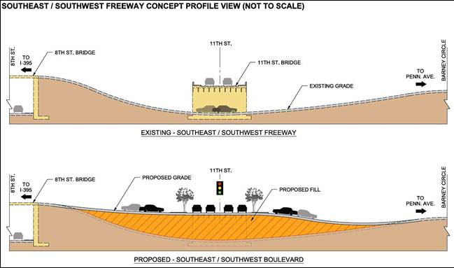
Over an 18- to 20-month period, the below-grade area between 8th and 13th streets SE will be raised about 20 feet, and the new boulevard will be created, as seen in this DDOT graphic. Since 11th Street currently crosses the below-grade lanes on a bridge, this means that that "bridge" will become an at-grade roadway as well.
And, speaking of that section of 11th Street, the advisory says that the new entrance to the westbound Southeast Freeway from 11th Street will open by Thanksgiving, allowing people on the eastern side of the Hill to get on the freeway at 11th rather than taking Virginia Avenue all the way to the 3rd Street SE ramp.
 This work is all part of the now-funded $90 million second phase of the 11th Street Bridges project, and also will include a new three-lane outbound bridge from the SE/SW Freeway to the 11th Street/I-695 bridge. In addition, 12th Street SE will be extended north from M Street to connect to the new Boulevard, and there will also be a reconfiguring of Barney Circle itself.
In the meantime, work continues on the many Phase 1 connections still being built, including a new off-ramp on the east side of the river from northbound DC-295 to the new 11th Street Local Bridge, which should be opening by the end of this month. Quoting DDOT: "This will allow Navy Yard morning rush-hour commuters coming from Suitland Parkway and northbound I-295 with more of a direct route to their facility as well as local traffic direct access to Historic Anacostia. Traffic will exit on the Anacostia side of the river, travel across the 11th Local Street Bridge and enter the Navy Yard at the O Street Gate."
The much-anticipated ramp to northbound DC-295 from the outbound I-695 bridge is expected to open by Thanksgiving.
You can see more about the coming ramps on the east side of the river on page 31 of this DDOT community communications briefing. There's also my post from a few months ago with more detail on this Phase 2, and of course, my 11th Street Bridges project page.
|
Comments (7)
More posts:
11th Street Bridges, Southeast Blvd., Traffic Issues
|
 Thursday night's game at Nationals Park against the Tampa Rays was a relatively painless 5-2 win for the Nats, upping the team's record to 40-27 before they make the quick trip up to Baltimore for a weekend rematch against the Orioles.
Announced paid attendance was 29,551, which pushed the mark for the 2012 season just above 1 million (1,002,396 for you sticklers). This is an average of 29,482 tickets sold per game through the first 34 of the season, compared to 22,948 at the same point last year. (The team didn't reach the 1 million mark in 2011's home attendance until July 9.)
According to Dan Steinberg, seven of the 13 biggest crowds in Nats Park history have come this season, three of them just last weekend for the Yankees series. The average through these first 34 games is a smidge higher than for the same span in the ballpark's inaugural 2008 season, and is no doubt well outpacing the 2009-2011 doldrums.
So, there's an average of 6,500-plus more bodies traipsing through the streets around the ballpark for every game this year than last year, along with far more sellouts and near sellouts than the ballpark has seen in its previous four seasons--how is this working out for the neighborhood? I haven't heard much carping--is this because traffic and humanity are generally moving well (albeit with a bit more patience required during the big games), or is it more because most Near Southeast residents moved to the neighborhood after the stadium opened, and so have no "before" frame of reference and are also more accepting of the crowds since they knew what they were getting into? (The point of view might be a bit different across the way in the established residential areas of Southwest.) Or does a winning record and a first-place team magically lessen the pain and grumbling?
|
Comments (7)
More posts:
Nationals Park, Traffic Issues
|
I wasn't able to attend last week's public meeting on the Virginia Avenue Tunnel, but the presentation slides and display boards are posted on the project's web site. 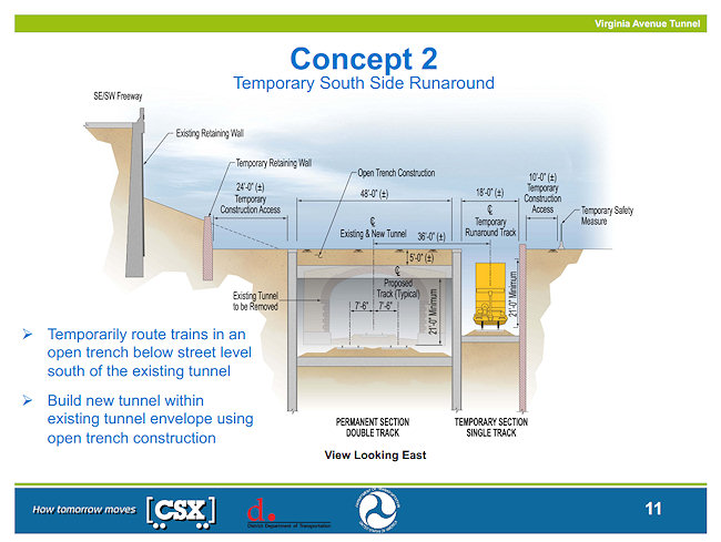
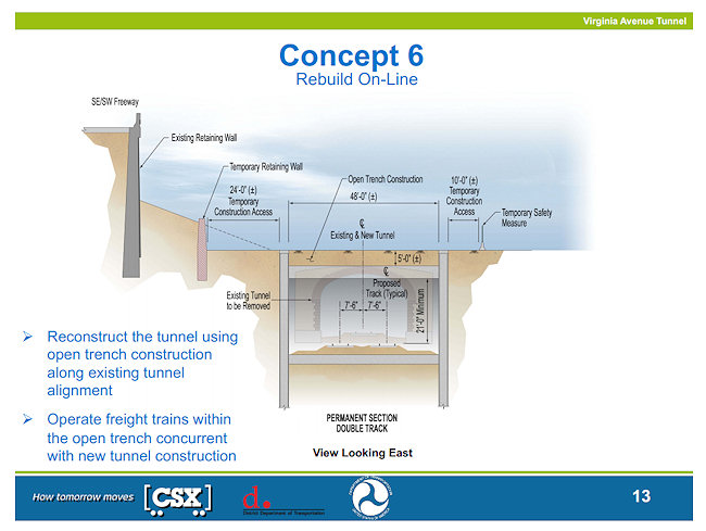
This is the stage of the Environmental Impact study where the initial lineup of possible concepts have been winnowed down to the four that will be evaluated for the final EIS:
* Concept 1 - "No Build" (i.e., leave as is);
* Concept 2 - Rebuild tunnel with a temporary track running in an open trench to the south of the existing tunnel;
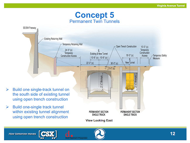
* Concept 5 - "Permanent Twin Tunnels," with a new tunnel built via open trench to the south of the existing tunnel, which would be rebuilt as well;
* Concept 6 - "Rebuild Online," where the current tunnel would be rebuilt via open trench along the existing alignment, and trains would run in that same trench during construction.
Also contained in the slides is information about how traffic would be routed with the closure of Virginia Avenue on the south side of the freeway between 2nd and 11th. As has always been stated, north/south traffic on the numbered streets would be maintained across Virginia, and temporary driveways/access are shown on 3rd and 4th Street for Capitol Quarter and the 200 I/225 Virginia loading dock. It's also shown that Virginia Avenue north of the freeway would become two-way between 6th and 8th streets, so that traffic exiting the Southeast Freeway at 6th would all be directed left under the freeway and then would be able to continue to 8th Street on Virginia.
There's also some slides on the vibration and noise analyses being done, and how Virginia Avenue might be improved after construction is completed (with bike lanes being a possibility, which immediately warmed David Garber's heart).
The draft Environmental Impact Statement is expected to be released this fall, in which the design for construction will be identified; the entire process would be completed in spring, 2013. Comments can be submitted to contact@virginiaavenuetunnel.com or via the web site.
|
Comments (0)
More posts:
CSX/Virginia Ave. Tunnel, meetings, Traffic Issues
|
To allow you to properly plan your calendar for the week, I'm posting this nice and early:
* Virginia Avenue Tunnel: Monday night is another public meeting on the planned Virginia Avenue Tunnel reconstruction, at which it's expected that DDOT, FHWA, and CSX will be presenting the concepts that have been chosen from the original batch to study in detail as part of the project's EIS. The meeting is at Nationals Park at 6 pm.
And, speaking of the tunnel, the noise and vibration field studies required as part of the EIS will be happening this week. (But no fair stomping on the ground and gunning your car's engines for hours at a time.)
* M Street SE/SW Transportation Study: The meeting to update the public on the progress of the M Street SE/SW Transportation Study is on Thursday, May 24, from 6:30 pm to 8 pm at the Capitol Skyline Hotel, 10 I St. SW. The study area covers the stretch of M from 12th Street, SE to 14th Street, SW, along with the adjacent areas from the Southeast/Southwest Freeway south to the Anacostia River/Washington Channel. DDOT is looking at "how to integrate transit, bicycling and walking with motor vehicle traffic," while also trying to figure out how to balance residents' preferences for how M Street should be configured versus how visitors, workers, and commuters expect it to flow. The first meeting was in January, and the final report is expected in the fall.
* Front Flicks: If you are looking for something slightly more entertaining than either of the week's meetings, don't forget that the Capitol Riverfront BID's free Front Flicks Summer Outdoor Movie Series begins this week on Thursday, with "Lara Croft: Tomb Raider" leading off the lineup of treasure hunt-themed offerings. Movies start either at 8:45 pm/sundown at Tingey Plaza, just behind USDOT at New Jersey and Tingey.
Alas, I won't be at any of these events, because first thing Tuesday I'm headed to the disabled list, to get some health issues dealt with that have been dragging me down for awhile now. There will be a few weeks of recovery time, so I ask all parties to please refrain from making any news before, say, mid-June, or at least make it something simple and/or something that won't require my attendance. (DDOT is already On Notice if they do indeed partially open the 11th Street Local bridge when I can't document it.)
I imagine I'll reappear on Twitter fairly quickly, since I know better than to think I can stay off the Internet while I'm doing little but laying around. But most likely the bulk of my narcotics-tinged/boredom-induced missives will be via my non-official @jacdupree account, if you want the entertainment.
In the meantime, feel free to use this post's comments to discuss this week's meetings and as a general open thread, but I will be watching and popping in, so don't you kids think you can throw a wild party while Mom's not looking! And hopefully I'll be back to photo taking and other obsessive-compulsive pursuits before too long.
|
Comments (3)
More posts:
Pedestrian/Cycling Issues, CSX/Virginia Ave. Tunnel, Events, meetings, M Street, JDLand stuff, Traffic Issues
|
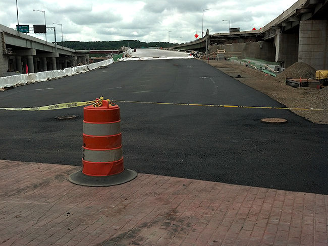
 DDOT is announcing that the the 8th Street exit ramp from the westbound Southeast/Southwest freeway is closing permanently on May 10 at approximately 10 am.
This is the ramp that drivers use coming from Pennsylvania Avenue and Barney Circle, not the one used for 8th Street when coming inbound from the 11th Street Bridge.
The closure is happening because the new flyover for traffic coming westbound from from the 11th Street freeway bridge will be bringing traffic onto the westbound freeway via a ramp that runs right across the 8th Street exit site (this photo of the ramp as seen from 11th Street from back in January shows on the far left where the 8th Street exit is and why it's having to be closed).
The Marines can't be too unhappy about this closure, since the ramp runs right between the two halves of Building 20, which isn't exactly a prime security configuration.
In the press release, DDOT also says that it expects the new ramp connecting Southbound DC-295 (on the east side of the river) with the inbound 11th Street Freeway Bridge (I-695) to open by July 4, and that this "will have a direct connection to I Street at 10th Street, SE" (which is where the current ramp from the inbound 11th Street Bridges is).
 As to when/how the other new ramp that will bring traffic up to 11th Street from the Pennsylvania Avenue/Southeast Freeway connector will open, I don't know. There are a lot of traffic flow changes are coming to 11th Street between I and O over the next few months--the new ramp to the outbound freeway bridge from M just east of 11th is looking closer to completion, as is the 11th Street Local bridge. If only someone would get over there to take some photos of the progress! (Well, I did take *one.*)
One of DDOT's spiffy videos detailing all the new movements sure would be handy about now.
|
Comments (0)
More posts:
11th Street Bridges, Traffic Issues
|
DDOT has announced that a meeting to update the public on the progress of the M Street SE/SW Transportation Study has been scheduled for May 24, from 6:30 pm to 8 pm at the Capitol Skyline Hotel, 10 I St. SW.
The study area covers the stretch of M from 12th Street, SE to 14th Street, SW, along with the adjacent areas from the Southeast/Southwest Freeway south to the Anacostia River/Washington Channel. DDOT is looking at "how to integrate transit, bicycling and walking with motor vehicle traffic," while also trying to figure out how to balance residents' preferences for how M Street should be configured versus how visitors, workers, and commuters expect it to flow.
The first meeting, back in January, included an introduction to the study before attendees broke up into small groups to give feedback about the issues they feel need addressing.
According to the web site, a draft study report is expected this summer, with the final report and a final public meeting coming in the fall.
|
Comments (1)
|
The meeting probably isn't even finished yet, but if you didn't (or did) stop by the first of DDOT's public meetings on their nine-month M Street SE/SW Transportation study, you can browse the presentation slides and take the stakeholder survey, already posted on the new web site for the project.There were a pile of high-powered bloggers and transportation geeks in attendance, so I'm sure there will no shortage of coverage of both this meeting and the entire study that I will happily link to, but there wasn't much news coming out of this first session--it was mainly to introduce the study, talk about the methodology (which you can see in the slides) and then break up into small groups to stand around maps and give feedback about what attendees see as issues that need addressing. (But first, just as at the 2010 meeting, one woman who is particularly anti-bike once again made her feelings known.)
DDOT's representatives say they will be using some 33 other studies that have been done on the area in question as part of this overall study, covering the area from 14th St. SW to 12th Street SE south of the freeway down to the waterfront(s), though that then brought a comment from the audience about when studying is going to stop and there's going to be action.
There will be two more public meetings, one in March-ish and another in June-ish, with the study expected to be completed in August-ish.
UPDATE: Here's DCist's report on the meeting. And SWill's.
|
Comments (2)
|
Just a reminder that Thursday night (Jan. 12) is the first public meeting for DDOT's M Street SE/SW Transportation Study, from 6:30 pm to 8:30 pm at Westminster Presbyterian Church at 400 I St., SW.
As the meeting announcement says, "The purpose of the public meeting is to provide an overview of the transportation study, outline the study process/schedule and gather public feedback. Following a brief presentation, attendees will be asked to help identify concerns and issues on maps of the study area and also via a brief survey."
It isn't just about the six lanes on M Street, either: the study area goes from the Southeast/Southwest Freeway south to the Anacostia River and Washington Channel, from 12th Street SE all the way to 14th Street SW.
So, if you think there should be fewer lanes, more lanes, less parking, more parking, more bike lanes, fewer bike lanes, more pedestrian-friendly changes, fewer pedestrian-friendly changes, or just like watching people with wildly divergent views all trying to get their position to be the "right" one, come on down.
(You can also read my post on the last M Street traffic meeting, back in 2010, though note it was not part of this current official nine-month study by DDOT.)
|
Comments (0)
|
ANC 6D has sent around (and posted! yay!) the agenda for its January meeting, scheduled for Monday, Jan. 9 at 7 pm at 1100 4th St., SW in DCRA's second-floor meeting room.
The Near Southeast items of interest could mostly be looked at as sneak previews, or perhaps as items that could be missed if you are better able to fit other upcoming meetings into your calendar (especially, if, say, you were looking for an escape hatch because you'd kinda rather be watching the BCS championship):
* There's a M Street SE/SW Transportation Study agenda item, in advance of the DDOT public meeting on the study coming three days later, on Jan. 12;
* There's an update on Capitol Riverfront BID doings, in advance of the BID's annual meeting three days later, on Jan. 12; and
* There's the application for historic landmark status for the DC Water main pumping station, which will be heard by the Historic Preservation Review Board at its January 26 meeting.
There's also an update on the ANC 6D redistricting outcome, various Southwest-related items (including the big Maryland Avenue SW Draft Plan, and whatnot. And, since it's the first meeting of the new year, there will also be the election of commission officers.
|
Comments (8)
More posts:
ANC News, Capitol Riverfront BID, Pedestrian/Cycling Issues, meetings, M Street, preservation, Traffic Issues, DC Water (WASA)
|
Just sent out by DDOT:
"The District Department of Transportation (DDOT) will hold the first in a series of public information meetings for the M Street SE/SW Transportation Study from 6:30 to 8 p.m. on Thursday, January 12, 2012 at the Westminster Presbyterian Church, 400 I Street SW.
"The nine-month study, being conducted as part of the larger Anacostia Waterfront Initiative, seeks to identify current and future transportation issues and possible mitigation strategies along the M Street SE/SW Corridor and Southwest/Southeast Waterfront areas from 12th Street SE west to 14th Street SW and from the Southwest/Southeast Freeway south to the Anacostia River/Washington Channel.
"The purpose of the public meeting is to provide an overview of the transportation study, outline the study process/schedule and gather public feedback."
UPDATE: Here's the DDOT meeting announcement.
|
Comments (6)
|
251 Posts:
Go to Page: 1 | 2 | 3 | 4 | 5 | 6 | 7 | 8 | 9 | 10 ... 26
Search JDLand Blog Posts by Date or Category
Go to Page: 1 | 2 | 3 | 4 | 5 | 6 | 7 | 8 | 9 | 10 ... 26
Search JDLand Blog Posts by Date or Category