
|
| |||||||||||||||||||

|
Please note that JDLand is no longer being updated.
peek >>
Near Southeast DC Past News Items: Traffic Issues
- Full Neighborhood Development MapThere's a lot more than just the projects listed here. See the complete map of completed, underway, and proposed projects all across the neighborhood.
- What's New This YearA quick look at what's arrived or been announced since the end of the 2018 baseball season.
- Food Options, Now and Coming SoonThere's now plenty of food options in the neighborhood. Click to see what's here, and what's coming.
![-]()
- Anacostia RiverwalkA bridge between Teague and Yards Parks is part of the planned 20-mile Anacostia Riverwalk multi-use trail along the east and west banks of the Anacostia River.
![-]()
- Virginia Ave. Tunnel ExpansionConstruction underway in 2015 to expand the 106-year-old tunnel to allow for a second track and double-height cars. Expected completion 2018.
![-]()
- Rail and Bus Times
Get real time data for the Navy Yard subway, Circulator, Bikeshare, and bus lines, plus additional transit information. - Rail and Bus Times
Get real time data for the Navy Yard subway, Circulator, Bikeshare, and bus lines, plus additional transit information. - Canal ParkThree-block park on the site of the old Washington Canal. Construction begun in spring 2011, opened Nov. 16, 2012.
![-]()
- Nationals Park21-acre site, 41,000-seat ballpark, construction begun May 2006, Opening Day March 30, 2008.
![-]()
- Washington Navy YardHeadquarters of the Naval District Washington, established in 1799.
![-]()
- Yards Park5.5-acre park on the banks of the Anacostia. First phase completed September 2010.
![-]()
- Van Ness Elementary SchoolDC Public School, closed in 2006, but reopening in stages beginning in 2015.
![-]()
- Agora/Whole Foods336-unit apartment building at 800 New Jersey Ave., SE. Construction begun June 2014, move-ins underway early 2018. Whole Foods expected to open in late 2018.
![-]()
- New Douglass BridgeConstruction underway in early 2018 on the replacement for the current South Capitol Street Bridge. Completion expected in 2021.
![-]()
- 1221 Van290-unit residential building with 26,000 sf retail. Underway late 2015, completed early 2018.

- NAB HQ/AvidianNew headquarters for National Association of Broadcasters, along with a 163-unit condo building. Construction underway early 2017.

- Yards/Parcel O Residential ProjectsThe Bower, a 138-unit condo building by PN Hoffman, and The Guild, a 190-unit rental building by Forest City on the southeast corner of 4th and Tingey. Underway fall 2016, delivery 2018.

- New DC Water HQA wrap-around six-story addition to the existing O Street Pumping Station. Construction underway in 2016, with completion in 2018.

- The Harlow/Square 769N AptsMixed-income rental building with 176 units, including 36 public housing units. Underway early 2017, delivery 2019.

- West Half Residential420-unit project with 65,000 sf retail. Construction underway spring 2017.
![-]()
- Novel South Capitol/2 I St.530ish-unit apartment building in two phases, on old McDonald's site. Construction underway early 2017, completed summer 2019.
![Novel South Capitol]()
- 1250 Half/Envy310 rental units at 1250, 123 condos at Envy, 60,000 square feet of retail. Underway spring 2017.
![-]()
- Parc Riverside Phase II314ish-unit residential building at 1010 Half St., SE, by Toll Bros. Construction underway summer 2017.
![-]()
- 99 M StreetA 224,000-square-foot office building by Skanska for the corner of 1st and M. Underway fall 2015, substantially complete summer 2018. Circa and an unnamed sibling restaurant announced tenants.
![-]()
- The Garrett375-unit rental building at 2nd and I with 13,000 sq ft retail. Construction underway late fall 2017.
![-]()
- Yards/The Estate Apts. and Thompson Hotel270-unit rental building and 227-room Thompson Hotel, with 20,000 sq ft retail total. Construction underway fall 2017.
![-]()
- Meridian on First275-unit residential building, by Paradigm. Construction underway early 2018.
![-]()
- The Maren/71 Potomac264-unit residential building with 12,500 sq ft retail, underway spring 2018. Phase 2 of RiverFront on the Anacostia development.
![-]()
- DC Crossing/Square 696Block bought in 2016 by Tishman Speyer, with plans for 800 apartment units and 44,000 square feet of retail in two phases. Digging underway April 2018.
![DC Crossing]()
- One Hill South Phase 2300ish-unit unnamed sibling building at South Capitol and I. Work underway summer 2018.
![One Hill South Phase 2]()
- New DDOT HQ/250 MNew headquarters for the District Department of Transportation. Underway early 2019.
![New DDOT HQ]()
- 37 L Street Condos11-story, 74-unit condo building west of Half St. Underway early 2019.
![37 L Condos]()
- CSX East Residential/Hotel225ish-unit AC Marriott and two residential buildings planned. Digging underway late summer 2019.
![CSX East Residential/Hotel]()
- 1000 South Capitol Residential224-unit apartment building by Lerner. Underway fall 2019.
![1000 South Capitol Residential]()
- Capper Seniors 2.0Reconstruction of the 160-unit building for low-income seniors that was destroyed by fire in 2018.
![1000 South Capitol Residential]()
- Chemonics HQNew 285,000-sq-ft office building with 14,000 sq ft of retail. Expected delivery 2021.
![1000 South Capitol Residential]()


251 Blog Posts Since 2003
Go to Page: 1 | ... 6 | 7 | 8 | 9 | 10 | 11 | 12 | 13 | 14 ... 26
Search JDLand Blog Posts by Date or Category
Go to Page: 1 | ... 6 | 7 | 8 | 9 | 10 | 11 | 12 | 13 | 14 ... 26
Search JDLand Blog Posts by Date or Category
Just sent out by DDOT: "Today the District Department of Transportation (DDOT) announced the start of land acquisition and preliminary design work for the South Capitol Street Project, which includes replacement of the current Frederick Douglass Memorial Bridge. [...] While the Record of Decision (ROD) is still pending, the Federal Highway Administration signed the project's Final Environmental Impact Statement (FEIS) following the requisite 30-day public comment period that ended in May."
I'm posting quickly, so I shall now crib unabashedly from my post on the Final EIS, from back in April:
If you are interested in this subject, there is more verbiage and documentation accompanying the plans than you could ever dream of. (Traffic studies! Environmental consequences! Technical reports!) And I've written a lot about the process, which began more than a decade ago with other studies before the EIS got underway. And I'm sure there will be posts on other blogs delving more specifically into portions of the plans. But, since most people probably want to know "what does this mean for me?", you can see this graphic (from the 224-MB chapter 2 of the FEIS) giving a quick overview of what changes are planned along South Capitol Street if the final EIS is signed off on (and, more importantly, if funding is secured). The short version, for the west side of the Anacostia:
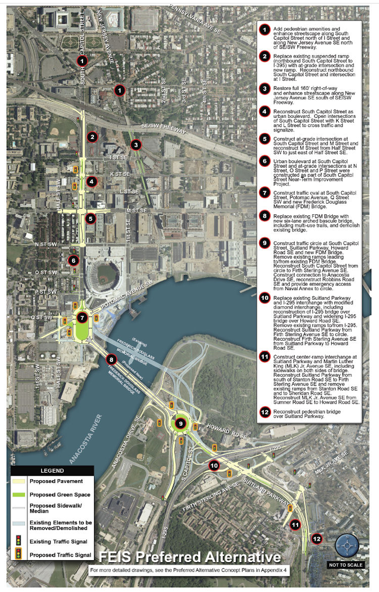 * Add "pedestrian amenities" and enhance the streetcape along South Capitol north of I and along New Jersey Avenue SE north of the freeway.
* Add "pedestrian amenities" and enhance the streetcape along South Capitol north of I and along New Jersey Avenue SE north of the freeway.
* Replace the existing ramp to the freeway from South Capitol and I with an at-grade intersection. (This would be a left turn onto a ramp to the freeway from under the freeway, near the current Nats HH economy parking lot.)
* Bring New Jersey Avenue SE back to a 160-foot full right-of-way, and add streetscape enhancements.
* "Reconstruct South Capitol Street as an urban boulevard." This means bringing M Street up to an "at-grade" intersection (no more tunnel), and would include new signalized at-grade intersections to allow traffic to cross South Capitol on K and L streets. (M Street would also get reconstructed between the Halfs [SE and SW].) The section of South Capitol north of M would have the same streetscape that the south portion received during its 2007/08 makeover, with wide sidewalks and a tree-lined median.
* Build a traffic oval at South Capitol, Potomac, Q, as the gateway to a new arched bascule-design Douglass Bridge that would have wide "multi-use trails" (i.e., sidewalks!) in both directions. The existing bridge would be demolished, after the new bridge is built somewhat downriver of the current location.
The Executive Summary (220 MB PDF) gives a good overview of the FEIS and preferred alternative (as it should!), but I also suggest wandering through the Chapter 2: Alternatives section, especially if you came to the neighborhood or JDLand after 2008 and didn't get to follow along during the EIS process, or if you're interested in the additional plans for east of the river, which I'm going to leave to others to discuss. My previous posts on all of this may be of interest as well. If you're wanting to see some of the earlier studies referenced in the FEIS, there are links to them at the top of my South Capitol Street project page.
How much would this all cost? The preferred alternative is priced in this final EIS at $806 million in FY 2014 dollars. (New bridges are expensive, you know.) Note that nothing in today's statement from DDOT says anything about funding, or a construction timeline.
You can also check my South Capitol Street and South Capitol Street Bridge page for all the info about the plans, along with my scores of posts over the past few years.
|
Comments (6)
More posts:
South Capitol St., Douglass Bridge, Traffic Issues
|
It's been so long since I've written about this that I forgot it was even still in progress, but DDOT has announced two public meetings to present the "preferred alternative" and the Final Environmental Impact Statement for the South Capitol Street Corridor, first on April 26 at Amidon-Bowen Elementary School in SW and then two days later at Savoy Elementary School in SE. This is the long-term study of how to improve South Capitol Street on both sides of the Anacostia River to better address safety, traffic, pedestrian, and streetscape issues, and includes the construction of a new Frederick Douglass Bridge.* Add "pedestrian amenities" and enhance the streetcape along South Capitol north of I and along New Jersey Avenue SE north of the freeway.
If you are interested in this subject, there is more verbiage and documentation accompanying the plans than you could ever dream of. (Traffic studies! Environmental consequences! Technical reports!) And I've written a lot about the process, which began more than a decade ago with other studies before the EIS got underway. And I'm sure there will be posts on other blogs delving more specifically into portions of the plans. But, since most people probably want to know "what does this mean for me?", you can see this graphic (from the 224-MB chapter 2 of the FEIS) giving a quick overview of what changes are planned along South Capitol Street if the final EIS is signed off on (and, more importantly, if funding is secured). The short version, for the west side of the Anacostia:
* Add "pedestrian amenities" and enhance the streetcape along South Capitol north of I and along New Jersey Avenue SE north of the freeway.* Replace the existing ramp to the freeway from South Capitol and I with an at-grade intersection. (This would be a left turn onto a ramp to the freeway from under the freeway, near the current Nats HH economy parking lot.)
* Bring New Jersey Avenue SE back to a 160-foot full right-of-way, and add streetscape enhancements.
* "Reconstruct South Capitol Street as an urban boulevard." This means bringing M Street up to an "at-grade" intersection (no more tunnel), and would include new signalized at-grade intersections to allow traffic to cross South Capitol on K and L streets. (M Street would also get reconstructed between the Halfs [SE and SW].) The section of South Capitol north of M would have the same streetscape that the south portion received during its 2007/08 makeover, with wide sidewalks and a tree-lined median.
* Build a traffic oval at South Capitol, Potomac, Q, as the gateway to a new arched bascule-design Douglass Bridge that would have wide "multi-use trails" (i.e., sidewalks!) in both directions. The existing bridge would be demolished, after the new bridge is built somewhat downriver of the current location.
The Executive Summary (220 MB PDF) gives a good overview of the FEIS and preferred alternative (as it should!), but I also suggest wandering through the Chapter 2: Alternatives section, especially if you came to the neighborhood or JDLand after 2008 and didn't get to follow along during the EIS process, or if you're interested in the additional plans for east of the river, which I'm going to leave to others to discuss. My previous posts on all of this may be of interest as well. If you're wanting to see some of the earlier studies referenced in the FEIS, there are links to them at the top of my South Capitol Street project page.
How much would this all cost? The preferred alternative is priced in this final EIS at $806 million (not billion! yeesh) in FY 2014 dollars. (New bridges are expensive, you know.)
(I know that this is a very quick overview of a big study and plan, but there will be plenty of time to talk more about it, especially with the upcoming public meetings.)
|
Comments (1)
|
Last missive from Monday's ANC 6D meeting..:
* It's apparently going to be "Neighborhood Day" at Nationals Park on Saturday, April 16. The Nationals said in a press release on Monday that residents will be able to purchase discounted tickets, but you apparently have to be in the know to find the nationals.com/neighborhood ticket sales link. (ANC commissioners got their free tickets for Saturday handed out at the meeting, since they'll be introduced on the field before the game.)
* With a unanimous 7-0 vote, the commission passed a motion authored by David Garber to request that DDOT fund a "comprehensive" traffic study of the M Street corridor and its neighboring streets in both Southeast and Southwest. Much of the discussion ended up centering around the wording of the motion (as is so often the case), with much concern about whether Maine Avenue should be specifically mentioned, especially given that the developers of the new Southwest Waterfront will be undertaking their own traffic study along Maine and Water Street. Commissioner Andy Litsky wondered about the traffic study in Southeast that the Capitol Riverfront BID is looking to fund, and Michael Stevens of the BID said that they would support a "holistic" approach to combining the various studies already done or on the boards (including the one CSX has apparently completed to look at the impact of their planned construction along Virginia Avenue, plus the reports done for the 11th Street Bridges EIS and the in-progress 14th Street Bridges EIS).
The motion was then amended to say that the ANC supports directing DDOT funds "to conduct a comprehensive traffic study and plan for the M Street SE/SW corridor and its feeder and surrounding streets and that all other area studies be integrated for DDOT's review in order to produce a comprehensive study, and that ANC 6D urgently supports the subsequent design process and implementation of a 'complete streets' plan to decrease the speed and volume of automobile traffic, and increase multi-modal transportation safety and efficiency as neighborhoods in 6D continue to evolve and develop."
(If you want to know more about the concept of Complete Streets and how it might inform a redesign of M Street, you can read my report on last year's public meeting held by Tommy Wells to start an "initial dialog" on the subject.)
* The commission also voted 7-0 to support the Pacers Home Run Classic 10K race, to be run on Saturday, June 18. Original plans to start and end the race at the Yards Park ran into some issues with the city's Emergency Management folks not wanting the race to run by the DC Water/WASA plant (and there was no explanation beyond that). So the race will now start and end at Half and N, across from the ballpark, then circle the ballpark down to South Capitol and Potomac before crossing the Douglass Bridge, running along Anacostia Drive in Anacostia Park to the skating pavilion, then doubling back. It's expected there will be 2,000 runners for the 8 am race. (Next year they expect to be able to start and end at the Yards Park and use the new floating bridge to Teague Park to get to Potomac Avenue and the Douglass Bridge.)
* In liquor license matters, it was reported to the commission that Das Bullpen did end up needing to get a new liquor license separate from that of The Bullpen 1.0, and that a new voluntary agreement was written up as well. This was all apparently done very hurredly, on the Tuesday before Opening Day, in order for ABRA to approve the new license on Wednesday in time for Opening Day on Thursday (though as we know Das Bullpen didn't open that day anyway). There's a full hearing on the license scheduled for May 31. If you haven't followed the Twitter flurry, Das Bullpen opened Tuesday (April 13) for the Nats/Phillies game.
* Also on the alcohol front, apparently both Harry's Reserve and Cornercopia are inquiring as to the possibility of the sale of "singles," in their cases to be the sorts of higher-end European beers that typically come in 20 oz or larger bottles. Coralee Farlee, who chairs the 6D ABC subcommittee, asked for some guidance as to whether the ANC is wanting to continue to not consider any exceptions for single sales, as has been the practice. David Garber and other commissioners expressed their support for the higher-end type of sales, and Andy Litsky said that 6D never really had the "singles" problem that lead the H Street NE corridor to ban those sales. Chairman Ron McBee instructed Farlee to check how other ANCs are handling the issue (apparently 6B allows sales of the 20-oz. bottles?), with an eye toward reexamining 6D's stance.
|
Comments (8)
|
There's nothing I like more when fighting a cold than to think about an upcoming ANC meeting, but these are the sorts of sacrifices I make for you people. Miraculously, ANC 6D has already posted the agenda for Monday's meeting, which is chock-full of Near Southeast-related items and is coincidentally being held in Southeast this time around, at the Courtyard by Marriott at New Jersey and L. Up for discussions and/or votes:
* The Market Deli historic landmark application, which will get a vote from the ANC as to whether or not to support it (and of course we know that at least one 6D commissioner will be voting for it!). The hearing in front of the Historic Preservation Review Board is scheduled for April 28.
* A presentation on the zoning request to allow Forest City to "temporarily" include office space in the Lumber Shed building in the Yards Park. I've written about this Lumber Shed request before, and in fact Forest City did a information presentation on this at last month's ANC meeting, but I was hoping to get copies of the new pretty renderings of the buildings before writing anything, and that never happened, and I knew they'd be back again in order to have a vote on whether the ANC will support the zoning request, so.... I promise to write about it this time.
* A resolution on a long-term traffic and transportation study for M Street SE and SW, also to include a "complete streets" plan, according to David Garber. This would appear to be wider in scope than the transporation study discussed in the draft Performance Parking report I wrote about recently that seemed to only cover the east side of South Capitol, but I imagine all will be clarified at the meeting.
* It turns out that Das Bullpen needs a new separate liquor license rather than operating on the Bullpen 1.0 license, so that's on the agenda as well. The hearing for that is scheduled for May 31, but the ANC will be voting on a "stipulated license," which I believe means that the bar could operate while waiting on the full license hearing. (And no, I haven't heard when they might be opening, though it wouldn't be before the next Nats home game, on April 12 vs. the Phillies.)
* And the BID is looking for support for the "Home Run Classic Pacers 10K Race" on June 18, that appears to start and/or end at the Yards Park and which I would guess (but don't know for sure) would involve some street closings.
The meeting begins at 7 pm, and does allow for short audience questions/statements on any agenda item where a vote will be taken, just in case there's any particular agenda item that people may feel strongly about one way or the other. (And all of this assumes that a government shutdown wouldn't affect an ANC meeting? Anyone?)
|
Comments (2)
More posts:
Alcohol/Liquor Licenses, ANC News, Fairgrounds/Bullpen, Events, meetings, M Street, Traffic Issues, The Yards, Yards Park
|
Michael Perkins at GGW got his hands on the draft version DDOT's 2010 Ballpark District Performance Parking Report, and while I'll leave it to him to handle the in-depth discussion of pricing and meter use in Near Southeast as well as other neighborhoods, there are a few action items in the report that might be of general interest (you should read all 31 pages if you want the nitty-gritty).
Now, this is a draft report, but assuming it becomes final...:
Revenues from the parking program have been able to provide $812,100 for "non-automotive transportation improvements" in 2011, which will include a new Capital Bikeshare location at the Yards Park and $135,000 for a new fence along New Jersey Avenue by the railroad tracks (presumably it won't hide the "Water Pylons" public art coming to the freeway underpass). There will also be two or three other new bikeshare stations somewhere in the Ballpark District parking zones (Near Southeast, Southwest, and southern Capitol Hill), but those haven't been announced.
There will also be a $70,000 grant to partially fund a Capitol Riverfront BID Transportation Study, which the page 25 of the report says will happen during this fiscal year and will look at:
* The need for additional traffic signals and stop signs based on pedestrian and vehicular patterns (and recent accidents);
* Neighborhood traffic circulation patterns including one way street circulation and freeway access and turning movements onto the freeway frontage roads;
* How the CSX tunnel reconstruction will impact traffic flow and SE/SW freeway access/egress;
* Existing and future parking demand and the proposed parking supply to meet that demand;
* On street parking strategies and supply for commercial, residential and visitor populations;
* Optimum Circulator routes and hours of operation;
* Recommended routes for bike lanes that tie into the Riverfront Trail system;
* The optimum route for a streetcar line in the M Street right of way and how it would service the Buzzard Point subdistrict; and
* How M Street is designed and works as a multi-modal transit corridor while exhibiting a high quality of design in the public realm.
Gosh, I'm just not sure if residents will be interested in any of these! If perchance a reader or two might have an idea or data point for the above items, feel free to discuss in the comments.
Note that this study doesn't quite seem to match the overarching Near Southeast/Southwest combined traffic study that got some discussion late last year, but perhaps there's more going on than what's mentioned in the DDOT report.
DDOT is also proposing that non-gameday parking rates at the multispace meters between South Capitol and 2nd Streets from the freeway to M Street go up to $6 for three hours (first hour $1.50, second hour $2.50, third hour $3). Plus, the boundaries of the parking zone will move eastward to 11th St. SE from 9th St.
By the way, if you have a fab idea for how some of the proceeds from the parking revenue can be spent on the aforementioned non-automotive transportation improvements, you can submit a written proposal to DDOT (further information on page 26 of the report). And if you want background on how the Performance Parking Pilot came into existence back in 2008, my Stadium Parking page can help with that.
|
Comments (2)
More posts:
Capitol Riverfront BID, Pedestrian/Cycling Issues, New Jersey Ave., parking, Traffic Issues, The Yards, Yards Park
|
I know one of my big complaints about St. Patrick's Day festivities has always been that there just aren't enough civic forums included. But that's not the case this year!
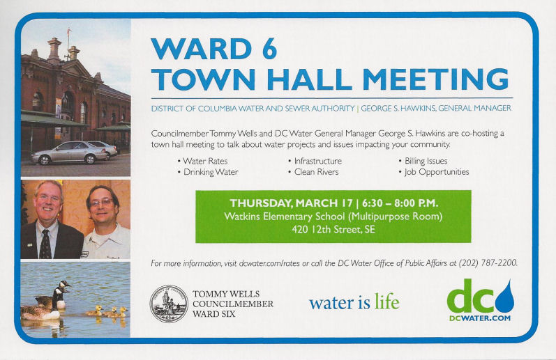
* This is late notice (my bad), but on Thursday night (March 17) DC Water (aka WASA) is holding a Ward 6 Town Hall Meeting to talk about all manner of water- and sewer-related issues. Both Tommy Wells and George Hawkins (general manager of DC Water) will be there, and no doubt one of the topics of discussion will be the multi-billion-dollar Clean Rivers Project to fix the combined sewer overflows that result in sewage emptying into the Anacostia River. I have done a wonderful job of avoiding writing about this project, and I will do so for a while longer, except to note that it will eventually mean construction work along M Street east of 9th and along Tingey Street, but not before next spring (and continuing until 2017), so I have a little more time to get with the program. The town hall is from 6:30 to 8 pm at Watkins Elementary, 420 12th St. SE.
* Unfortunately, the DC Water town hall is scheduled at the exact same time as the "First Semi-Annual DC Circulator Public Forum," which is being held right in the neighborhood at the Courtyard by Marriott at New Jersey and L SE, and which is expected to include a discussion of a possible expansion of service on the Union Station-Navy Yard line, perhaps by expanding hours of operation to 9 pm Monday-Saturday during baseball season. (There is, however, no truth to the rumor that the route is going to be renamed the Dubliner-Molly Malone's line.)
|
Comments (1)
|
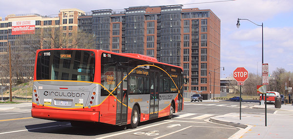 DDOT has announced the "First Semi-Annual DC Circulator Public Forum," with Near Southeast residents hitting the jackpot since it's being held at the Courtyard by Marriott at New Jersey and L, SE. It's scheduled for Thursday, March 17, from 6:30 pm to 8 pm, and the release says it will cover topics "including potential changes to the span of the Union Station-Navy Yard route."
 In subsequent tweets over the past few days, the Circulator folks have expanded on that, saying that they'll be talking about extending the hours on the route until 9 pm Mondays through Saturdays during the baseball season (April-September), and that it may be paid for by ending the weekend-only service on the Mall. (Other tweets hint that the National Park Service may eventually "support" a Mall route using Madison and Jefferson drives.)
They asked for feedback: would there be support in the neighborhood for running the buses until 9 pm? Is there another service improvement you'd rather see in place of that?
|
Comments (1)
More posts:
circulator, meetings, Traffic Issues
|
From DDOT, an announcement of two overnight closures of the outbound 11th Street Bridge this week, from 10 pm Wednesday (Jan. 26) through 5 am Thursday (Jan. 27), then again at 10 pm that night (the 27th) through 5 am on Friday the 28th. "Setup activity" for the closures will begin at 8 pm. The closures are to allow for overhead girder construction work.
The inbound bridge will remain open. For detour routes and other information, see the press release. It does note that if there's inclement weather, the closures will be rescheduled to the same overnight hours on Sunday, Jan. 30. And, given the Wednesday night forecast, it is possible that slot will get rained or snowed out (more likely rained).
|
Comments (0)
More posts:
11th Street Bridges, Traffic Issues
|
City Paper's Housing Complex blog reported late Friday afternoon that DDOT has decided to put in a "Barnes Dance" configuration (also known as a pedestrian scramble) at New Jersey and M, SE, sometime early in 2011. This is the setup where traffic on all sides have a red light at the same time, allowing pedestrians to cross in any direction. The first one in DC was put in at 7th and H in Chinatown a few months ago. With so many people needing to cross diagonally to go between the Navy Yard Metro station entrance and USDOT, this is probably a good choice for another intersection to try it out.
(Though I do dream of a day far in the future, when Forest City builds an office building on the NGA site on the southwest corner of the intersection as part of the Yards, that that new construction would include an additional entrance to the Metro station, obviating the need for people on the south side of M to cross the street to get to the subway.)
|
Comments (0)
More posts:
Pedestrian/Cycling Issues, Traffic Issues
|
At Monday's ANC 6D meeting, Bryon Johnston of the 11th Street Bridges Project gave a presentation on the rebuilding of the bridges, including an overview of the design and its main features as well as an update on the construction progress. He was nice enough to pass along the slides, which may not mean quite as much without his narration but are still helpful for people who haven't been following along through the process.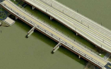 * Another feature that appears to be coming together for pedestrians and bicyclists is creating two overlooks that jut out above the river on the south side of the local bridge--these would use two of the in-water piers from the current downriver bridge, and you can see them at left and on slide 11.
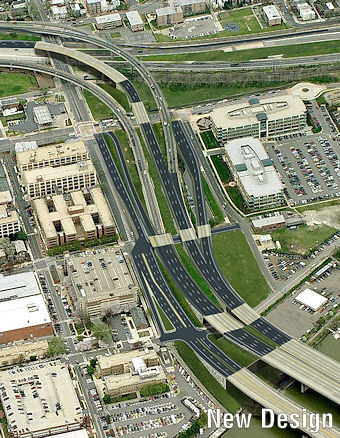 * To go across the river from Near Southeast on the freeway bridge, for access to DC-295 northbound and I-295 southbound, drivers will have a new ramp on the southeast corner of 11th and M (slide 4). The existing ramp at 8th and Virginia will still be available, too.
A few parts of the new design on the Near Southeast side of the project are worth (re-)pointing out, if you can make it through my torrent of descriptions:
* The "freeway" traffic and the "local" traffic will now be separated, with four lanes inbound and four lanes outbound on the freeway/upriver bridge and two lanes inbound/outbound on the "local"/downriver bridge (which Johnston was referring to as "Local 11th Street" because 11th will now feel like a street that crosses a river), as shown on slide 10.
* The local bridge will allow easier access between Near Southeast and Anacostia, for not only cars but pedestrians and bicycles, as well as streetcars when the routes are expanded. As part of this, 11th Street south of M is going to become two-way, and there will be bike lanes in both directions on 11th north of the bridge. (Slide 9)
* Another feature that appears to be coming together for pedestrians and bicyclists is creating two overlooks that jut out above the river on the south side of the local bridge--these would use two of the in-water piers from the current downriver bridge, and you can see them at left and on slide 11.* One of the big changes for traffic flow for both Near Southeast and Capitol Hill is that there is going to be a new two-lane on-ramp to go westward on the Southeast Freeway toward Virginia at 11th Street, underneath where the current flyover ramps are. (See slide 7.) Folks who have easier access to 11th Street will no longer have to drive along Virginia Avenue and/or 3rd Street to go westbound on the freeway.
But part of this new 11th Street intersection is that traffic coming from Pennsylvania Avenue along the sunken road that currently feeds directly into the freeway will instead be brought up to street level at this new signalized 11th Street intersection and will then drive straight onto the new on-ramp. So there will be some consternation from drivers using this route. (This is also shown on slide 7.)
* To go across the river from Near Southeast on the freeway bridge, for access to DC-295 northbound and I-295 southbound, drivers will have a new ramp on the southeast corner of 11th and M (slide 4). The existing ramp at 8th and Virginia will still be available, too. * There will still be an exit ramp from the inbound freeway bridge to I Street, just as there is now (slide 4).
* If you look at slide 4 very closely (and/or click on the bird's-eye view at right) and follow the paths off of each bridge, you can see how the freeway bridges coming across the river will have an exit for M Street similar to the current exit, but it deposits drivers at M just west of 12th instead of using 12th itself. It also no longer has the neat little N Street cut-through directly from the ramp that some Navy Yard workers cherish. To get to the Navy Yard, drivers will turn left on M, then left at 11th, and then go to whichever gate they need.
Other information in the slides includes: a graphic showing of the new ramps and accesses on the east side of the bridges at 295 and MLK (slide 12), of which the biggest addition is that you'll now be able to get to and from 295 and the bridges in all directions. There's also recent construction photos (including the first structural steel being laid on the freeway bridge), and information on stormwater management areas, and upcoming traffic impacts (slide 19).
It's expected that the freeway bridge will open about a year from now, with the new local bridge being finished in the winter of 2012/2013. (Dr. Gridlock wrote about recent milestones and upcoming work a few weeks ago.)
If you want to know more, there's my 11th Street Bridges project page, and you can also spend a couple months reading the Environmental Impact Statement to see all the studying they did of potential, um, impacts. There's also this Fact Sheet that they handed out.
|
Comments (0)
More posts:
11th Street Bridges, Traffic Issues
|
251 Posts:
Go to Page: 1 | ... 6 | 7 | 8 | 9 | 10 | 11 | 12 | 13 | 14 ... 26
Search JDLand Blog Posts by Date or Category
Go to Page: 1 | ... 6 | 7 | 8 | 9 | 10 | 11 | 12 | 13 | 14 ... 26
Search JDLand Blog Posts by Date or Category