
|
| |||||||||||||||||||

|
Please note that JDLand is no longer being updated.
peek >>
Near Southeast DC Past News Items: Traffic Issues
- Full Neighborhood Development MapThere's a lot more than just the projects listed here. See the complete map of completed, underway, and proposed projects all across the neighborhood.
- What's New This YearA quick look at what's arrived or been announced since the end of the 2018 baseball season.
- Food Options, Now and Coming SoonThere's now plenty of food options in the neighborhood. Click to see what's here, and what's coming.
![-]()
- Anacostia RiverwalkA bridge between Teague and Yards Parks is part of the planned 20-mile Anacostia Riverwalk multi-use trail along the east and west banks of the Anacostia River.
![-]()
- Virginia Ave. Tunnel ExpansionConstruction underway in 2015 to expand the 106-year-old tunnel to allow for a second track and double-height cars. Expected completion 2018.
![-]()
- Rail and Bus Times
Get real time data for the Navy Yard subway, Circulator, Bikeshare, and bus lines, plus additional transit information. - Rail and Bus Times
Get real time data for the Navy Yard subway, Circulator, Bikeshare, and bus lines, plus additional transit information. - Canal ParkThree-block park on the site of the old Washington Canal. Construction begun in spring 2011, opened Nov. 16, 2012.
![-]()
- Nationals Park21-acre site, 41,000-seat ballpark, construction begun May 2006, Opening Day March 30, 2008.
![-]()
- Washington Navy YardHeadquarters of the Naval District Washington, established in 1799.
![-]()
- Yards Park5.5-acre park on the banks of the Anacostia. First phase completed September 2010.
![-]()
- Van Ness Elementary SchoolDC Public School, closed in 2006, but reopening in stages beginning in 2015.
![-]()
- Agora/Whole Foods336-unit apartment building at 800 New Jersey Ave., SE. Construction begun June 2014, move-ins underway early 2018. Whole Foods expected to open in late 2018.
![-]()
- New Douglass BridgeConstruction underway in early 2018 on the replacement for the current South Capitol Street Bridge. Completion expected in 2021.
![-]()
- 1221 Van290-unit residential building with 26,000 sf retail. Underway late 2015, completed early 2018.

- NAB HQ/AvidianNew headquarters for National Association of Broadcasters, along with a 163-unit condo building. Construction underway early 2017.

- Yards/Parcel O Residential ProjectsThe Bower, a 138-unit condo building by PN Hoffman, and The Guild, a 190-unit rental building by Forest City on the southeast corner of 4th and Tingey. Underway fall 2016, delivery 2018.

- New DC Water HQA wrap-around six-story addition to the existing O Street Pumping Station. Construction underway in 2016, with completion in 2018.

- The Harlow/Square 769N AptsMixed-income rental building with 176 units, including 36 public housing units. Underway early 2017, delivery 2019.

- West Half Residential420-unit project with 65,000 sf retail. Construction underway spring 2017.
![-]()
- Novel South Capitol/2 I St.530ish-unit apartment building in two phases, on old McDonald's site. Construction underway early 2017, completed summer 2019.
![Novel South Capitol]()
- 1250 Half/Envy310 rental units at 1250, 123 condos at Envy, 60,000 square feet of retail. Underway spring 2017.
![-]()
- Parc Riverside Phase II314ish-unit residential building at 1010 Half St., SE, by Toll Bros. Construction underway summer 2017.
![-]()
- 99 M StreetA 224,000-square-foot office building by Skanska for the corner of 1st and M. Underway fall 2015, substantially complete summer 2018. Circa and an unnamed sibling restaurant announced tenants.
![-]()
- The Garrett375-unit rental building at 2nd and I with 13,000 sq ft retail. Construction underway late fall 2017.
![-]()
- Yards/The Estate Apts. and Thompson Hotel270-unit rental building and 227-room Thompson Hotel, with 20,000 sq ft retail total. Construction underway fall 2017.
![-]()
- Meridian on First275-unit residential building, by Paradigm. Construction underway early 2018.
![-]()
- The Maren/71 Potomac264-unit residential building with 12,500 sq ft retail, underway spring 2018. Phase 2 of RiverFront on the Anacostia development.
![-]()
- DC Crossing/Square 696Block bought in 2016 by Tishman Speyer, with plans for 800 apartment units and 44,000 square feet of retail in two phases. Digging underway April 2018.
![DC Crossing]()
- One Hill South Phase 2300ish-unit unnamed sibling building at South Capitol and I. Work underway summer 2018.
![One Hill South Phase 2]()
- New DDOT HQ/250 MNew headquarters for the District Department of Transportation. Underway early 2019.
![New DDOT HQ]()
- 37 L Street Condos11-story, 74-unit condo building west of Half St. Underway early 2019.
![37 L Condos]()
- CSX East Residential/Hotel225ish-unit AC Marriott and two residential buildings planned. Digging underway late summer 2019.
![CSX East Residential/Hotel]()
- 1000 South Capitol Residential224-unit apartment building by Lerner. Underway fall 2019.
![1000 South Capitol Residential]()
- Capper Seniors 2.0Reconstruction of the 160-unit building for low-income seniors that was destroyed by fire in 2018.
![1000 South Capitol Residential]()
- Chemonics HQNew 285,000-sq-ft office building with 14,000 sq ft of retail. Expected delivery 2021.
![1000 South Capitol Residential]()


251 Blog Posts Since 2003
Go to Page: 1 | 2 | 3 | 4 | 5 | 6 | 7 | 8 | 9 | 10 ... 26
Search JDLand Blog Posts by Date or Category
Go to Page: 1 | 2 | 3 | 4 | 5 | 6 | 7 | 8 | 9 | 10 ... 26
Search JDLand Blog Posts by Date or Category
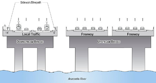
Dr. Gridlock reports that this morning the mayor held a press conference to (officially?) announce that the city will be rebuilding the 11th Street Bridges, with "in-water" work beginning in August. My project page gives the basics on what will be happening (along with links to the EIS), if you haven't been following along, but here's the high-speed recap: still two spans, but the upriver one would be expanded to become an eight-lane freeway span that would add the missing connection ramps between I-395 and I-295, while the downriver span would be four-lane "local" span tieing together Anacostia and Near Southeast, with pedestrian and bike paths and would be prepped for eventual streetcar usage. The project is expected to be completed in 2013.
UPDATE: The press release from DDOT has just come out, and apparently the real announcement of the day was the awarding of the design/build contract for the project to Skanska/Facchina.
UPDATE II: Additional pieces, from WTOP and from the Examiner, which talks about the lawsuit filed in February by the Capitol Hill Restoration Society to stop the project.
|
Comments (0)
More posts:
11th Street Bridges, streetcars, Traffic Issues
|
Catching up from a few days of slacking:
* Today's Washington Business Journal (subscribers only) reports that the city is "considering" using 225 Virginia Ave. (the old Post Plant) as the new home for Child and Family Services, now that they've decided not to move the agency to a new development at Benning Station. The city continues to pay $6 million a year in rent on the 420,000-sq-ft building, though tried a request for proposals last year to see about a sublease or sale of the property (but apparently didn't get much interest). I wonder how much the city would have to spend the rejigger the very warehouse-y building into the 180,000 sq ft of office space needed by CFSA.
* From the Fredericksburg Free-Lance Star, a story that Prince William County is spending $225,000 to look at passenger ferry service up the Potomac: "It will conduct test boat runs on May 4, 5 and 6 from stops at Prince William marinas at Quantico, Dumfries and Occoquan to Fort Belvoir, Alexandria and the Washington Navy Yard. The test boat will be a catamaran that seats 149." (I assume they'd want to use the dock under construction at Diamond Teague Park, but there's no specifics.)
* On Wednesday evening, the Post reported (though the article is no longer on the web site) that the city had informed Metro--in the middle of a game!--that it would no longer pay the $27,000-an-hour cost of keeping the subway open if games at Nationals Park ran late because of extra innings or rain delays. By the next morning, the city had changed its mind.
* The Douglass Bridge will be closed Sunday (4/26) from 5am to approximately 10am for the monthly swing span test.
|
Comments (0)
More posts:
225 Virginia/Old Post Plant/200 I, Metro/WMATA, Douglass Bridge, Nationals Park, Teague Park, Traffic Issues, Water Taxis/Riverboats
|
* (h/t reader F) The AP takes a look at the Capitol Power Plant just north of the SE Freeway, the neighborhood's second most "favorite" landmark (after the school buses) with its smokestacks obscuring the view of the Capitol dome from many locations. On Thursday, Harry Reid and Nancy Pelosi wrote a letter to the Architect of the Capitol asking that the power plant switch from burning coal to using natural gas for its operations, saying "The switch to natural gas will allow the CPP to dramatically reduce carbon and criteria pollutant emissions, eliminating more than 95 percent of sulfur oxides and at least 50 percent of carbon monoxide...We strongly encourage you to move forward aggressively with us on a comprehensive set of policies for the entire Capitol complex and the entire Legislative Branch to quickly reduce emissions and petroleum consumption through energy efficiency, renewable energy, and clean alternative fuels." The AP's story tells how Congress has been trying to clean up the plant and make it more "green," and the potholes in the road to making it run completely on natural gas. I'm guessing it wouldn't be wise to start counting the minutes until the smokestacks are gone.
* On Monday at 6:30 pm the Zoning Commission is scheduled to have its hearing on the Phase 2 plans for the park at The Yards, though we'll see if the weather wreaks havoc with the schedule. Here's my notes on the presentation of the designs to ANC 6D, and my Yards Park page has renderings.
* (UPDATE) Missed this--the Examiner reported on Friday that the Capitol Hill Restoration Society has filed suit to stop construction of the new 11th Street Bridges, citing its "significant, irreversible, adverse effects" on the surrounding area. The CHRS web site has a bit more detail as well.
* Tickets still available for Elton and Billy. Apparently there was a bit of a glitch yesterday when they went on sale.
|
Comments (0)
More posts:
11th Street Bridges, meetings, Stadium Events, Traffic Issues, The Yards, Yards Park, zoning
|
* From Dr. Gridlock, news about a work session being held today by the Metro board of directors to find ways to close their budget shortfall. On the long list of items: closing the east entrance of the Navy Yard station (at New Jersey and M) on weekends, unless there's an event at the ballpark. Metro numbers say that fewer than 700 people use that gate on weekends. The P2 line that I believe runs down M Street could also be on the chopping block. See the list here, though remember it's just a first cut at ideas.
* From Tommy Wells: "On Monday, February 23rd, Councilmember Wells will host a Community Forum on the Latest Information Regarding Lead in DC Drinking Water. [..] Officials will be on hand from the DC Water and Sewer Authority, District Department of the Environment, District Department of Health, Washington Aqueduct and DC Appleseed to address your concerns and questions regarding the lead levels in the DC water system." It will be at Tyler Elementary School at 10th and G, SE, at 6:30 pm.
* And a swing span test at the Douglass Bridge will take place on Sunday morning (Feb. 22), with the bridge being closed from 5 am to approximately 10 am.
|
Comments (0)
More posts:
Metro/WMATA, Nationals Park, Traffic Issues
|
* With thanks to SWill for passing the word (since I couldn't attend the meeting), I can report that ANC 6D on Monday night voted to support the plans for phase 2 of the Yards Park, which will be going in front of the Zoning Commission on March 2. (You can read my summary of last week's presentation to the ANC on the plans for more information.)
* If you're looking for analysis of what exactly the plans for the new 11th Street Bridges configuration might mean, Greater Greater Washington is taking a look at them (part one here; part two not yet posted). For what might perhaps be called an opposing viewpoint, DDOT's chief engineer Kathleen Penney contributed this article in the February Hill Rag about what DDOT sees as the benefits of the project. And, if you want some 11th Street Bridges material to use as a sleeping aid, I pass along this link (via Tommy Wells's blog) to the RFP for the design/build contract. (The "amendment" link is the *slightly* more comprehensible one.) There was a hearing last week on a bill about the contracting procedures for the bridge, but I'm not *so* desperate for content to wade into that.
(UPDATE) I already posted about this, but it's a good time to mention again that there's a public forum on the 11th Street Bridges on Feb. 17: "Sustainable Development, Infrastructure, and the Future of the District of Columbia," at the MLK Library at 6:30 pm. (DDOT just sent around its own announcement, now posted online.)
* And hey, check it out, the council has finally updated the user interface for its legislation database!
* Other than that, all is very quiet these days. Though those following my Twittering were apprised yesterday of this breaking news item: "[I] Dreamt last night that 3rd and K Market was reopening both as a bodega and a swank Indian food joint. With a new noodle place next door."
|
Comments (0)
|
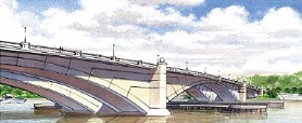
ANC 6D heard a presentation on Monday night from the team working on the South Capitol Street Environmental Impact Statement, which is now in its "final preferred alternative" stage. Their PowerPoint presentation was pretty close to the one I posted last month, and one of the consultants did tweak me a bit about how I "spoiled the surprise" on the choice of the arched bascule design for the new Douglass Bridge.
Here again are the (long!) bullet points about what the preferred alternative designs are for the portion of South Capitol west of the Anacostia (see the presentation if you're interested in the preferred alternatives chosen for east of the river), along with some issues raised by the ANC:
* It was emphasized that these new designs will not be adding any capacity, but that the main goal is to bring back the "boulevard" feeling of the corridor.
* The new bridge will have 20-foot-wide sidewalks on each side, and only two piers will need to be built in the river, compared to 3-5 piers that would have been needed with the other designs. (The cable stayed swing bridge would have had just one pedestrian/bike path, 16 feet wide, in the middle of the bridge, surrounded by six lanes of traffic.)
 * There will be a seven-acre traffic oval at the foot of the new bridge (which will be located to the south of the current bridge), reshaping the intersection of South Capitol Street and Potomac Avenue. (The ballpark's Home Plate Gate and entrance promenade will be the northeast edge of the oval.) The city is already in the process of acquiring seven properties or portions of properties that will be needed for the oval and bridge footprint, including the red brick warehouse on the northwest corner of South Capitol and Potomac. This oval is on the NCPC list of locations for future memorials and museums.
* The intersection of South Capitol Street and M Street will become an at-grade intersection (no more underpass for through traffic). ANC chair Andy Litsky expressed great concern about how this could make the intersection even more dangerous than it already is, to which the DDOT team replied that the reconfiguration should make it safer. (Certainly it would seem that having a "normal" intersection with two left-turn lanes in most directions would be an improvement safety-wise over the existing mish-mash of lights and poorly striped turn-lanes, but then there will also be a lot more cars cycling through once the tunnel lanes are gone.)
* There will be modifications to South Capitol's interchange with the SE/SW Freeway, with the replacement of the ramp that begins at I Street with an at-grade intersection underneath the freeway that would have two left-turn lanes to a new ramp. With the existing ramp removed, the intersection at South Capitol and I would also be reconfigured.
* The northern section of South Capitol Street will match the reconfigured portion between N Street and Potomac Avenue, as a six-lane boulevard with a median and wide sidewalks.
Commissioners McBee and Moffatt asked as they have in the past about whether the existing bridge could be kept as a pedestrian/bike-only bridge, but DDOT explained that since the swing span would continue to need to be opened for river traffic, the cost of maintaining the old bridge just isn't feasible. (The RiverFront folks might also be a teensy bit upset that their land that's beneath the current bridge wouldn't be coming back to them.) And the team also indicated that this new bridge does not preclude the construction (Some Day, Perhaps, in Some Far Off Time) of a tunnel to move non-local traffic from Anacostia to I-395.
They expect the final Record of Decision from the feds this fall; however, when pressed for a start date, they said 2011 would be the absolute earliest for the start of construction (with completion possibly in 2015), but that as of now there's no funding for the $700 million project. It's also possible that portions of the designs could be undetaken if partial funding is received.
|
Comments (0)
|
Some items from the past few days. Big ones first:
* It's probably been true for weeks, but I've just now been by Diamond Teague Park for the first time in a while and can confirm that construction is definitely underway there. Fences are up, cranes (three of them?) are in place, and workers were there. Pictures tomorrow. (Probably *lots* of pictures tomorrow from all over, as long as the weather stays reasonably clear.)
* City Paper got its hands on the letter Mayor Fenty sent to DC Delegate Norton about the city's priorities should the Feds decide to toss some stimulus package dollars in this direction. As I predicted, the two Near Southeast bridge projects were mentioned: "In particular, aspects of the Eleventh Street and South Capitol Street Bridge replacement projects could be undertaken immediately." He also mentions the city's backlog of maintenance projects, along with investments in Metro and the implentation of the streetcar project. And school modernization. And public safety issues.And environmental initiatives. And housing affordability. And health care. (And now here's the stimulus bill itself, though it doesn't get down into specific projects. On the other hand, considering these two bridges ease the commutes to and from the district of the House Majority Leader....)
* Back in mid-November, the transfer of the plot of land known as Reservation 17A from the Feds to the city finally took place; it runs between New Jersey Avenue and Second Street, and is straddled by the trash transfer station building. With this now under District control, various wheels can start turning in that area, including allowing the establishment of I Street between Second and New Jersey that will form the southern boundary of WC Smith's 800 New Jersey Avenue project. There's hopes that the trash transfer station could be demolished in 2010.
* Reader T. reported yesterday that a small bought-at-the-hardware-store For Sale sign went up at 10th and M yesterday, in front of the fence of the Exxon station. I'm not sure what the deal is, since the land is actually owned by the Exxon Corporation, and you'd think they'd have better methods of marketing the land.
* The public notice for the March 19 Zoning Commission hearing on various Capper PUD alteration requests is now available.
* WBJ reports that the Nationals have parted ways with Centerplate, last year's concessionare at the ballpark. This year it will be Levy Restaurants for the food and Facility Merchandising Inc. for the retail.
* More of the fences are coming down at 55 M, as you can see on the web cam. (Though it took me more than a month to notice that the plywood "tunnel" at the Metro exit had disappeared.)
* The Douglass Bridge will be closed at 5 am Sunday until 10am-ish to test the swing span.
|
Comments (0)
More posts:
11th Street Bridges, 55 M St., Trash Transfer Site/DPW, Monument Valley/Half St., New Jersey Ave., Douglass Bridge, WC Smith/Square 737, streetcars, Teague Park, Traffic Issues, zoning
|
Since it's slipped down the home page a bit, here's my Near Southeast Inauguration Road Closures and Parking Restrictions page, again. I've also added the information on parking at Nationals Park to the page as well.
I also did a bit of wandering around the Click and Park web site where bus companies can reserve their parking, and I see that all bus parking at Nationals Park is sold out. Also, all bus parking spots on Second Street, SE between Virginia and M are sold out, but the other Near Southeast streets are still available for reservations. (All Southwest bus parking is sold out.)
Residents by these bus-parking streets might want to put in earplugs on Monday night at bedtime, since the buses are being told to arrive at their parking zones between 4:30 and 6:30 am Tuesday morning.
Also, the city now has this map (3 MB PDF) showing the bus parking zones, "pedestrian priority" walking routes, bus routes, and other information for the Mall and the areas to the south. I can't quite figure out if you can continue up South Capitol Street toward Washington Avenue and then get to Independence Avenue and the Mall that way because that's part of the restricted area, but maybe as long as you're on the south side of the Independence it's okay? So look for a pretty fair amount of foot traffic on New Jersey Avenue and I Street as people walk from Capitol Hill and points south and east.
|
Comments (0)
|
* Last week I posted about the "DC Inaugural Gala" scheduled for Monday, Jan. 19 at the US DOT HQ at New Jersey and M. I didn't have much information, but a little more has come down the pike. It will be featuring the O'Jays and Salsa "king" Johnny Pacheco, as well as local artists Brian Lanier, Familiar Faces, Tommy Bryant and the Giants of Sound, and Nuera.
Mayor Fenty, Council Chairman Gray, and DC delegate Eleanor Holmes Norton are scheduled to attend, and it's being billed as the first (outside) event ever held at US DOT. Also, according to the press release, "The hundreds of guests in attendance also will be able to visit small intimate parties in special 'neighborhood rooms' that will be decorated by residents to make local people feel at home and give visitors a taste of District of Columbia communities."
Ticket prices have been, um, revised to $144 per person, along with higher-priced tickets with additional bells and whistles. Tickets can be purchased online at DCPresidentialGala.com (though as of Sunday afternoon it still lists the previous higher price for single tickets).
And, FYI, my employer doesn't let me go to inaugural balls other than on official business, so everyone be sure to tell me all about the parties, and think about me while I stay home cleaning the house and cursing my wicked stepmother and stepsisters.
* The Coast Guard has released the specifics of the security on the Anacostia and Potomac rivers surrounding the inauguration. On Jan. 18 and 19, recreational boaters will not be allowed in the security zone (which, for the Anacostia, is from Route 50 down to the Potomac), and those moored within the zone must not move without authorization. From 11 pm Jan. 19 until early Jan. 21, all vessel movements (recreational and commercial) will be prohibited.
And now, rehashing the other Twitter updates of the past few days:
* Tommy Wells has posted the list of Ward 6 establishments that have applied to stay open during the Inauguration extended hours. None of the hundreds of Near Southeast restaurants and bars are on the list (unless you want to count the Capitol Skyline Hotel at South Capitol and I, SW), but a number of Southwest Waterfront, Barracks Row, and Pennsylvania Avenue joints are on the list.
* It's a shame that Diamond Teague Park isn't done yet, because it could have gotten into the Inauguration Water Taxi biz--the Post's Inauguration Watch blog reported on Friday that there will be water taxi service from Alexandria to 600 Water Street, SW (Pier 4). $90 round-trip, $50 one-way. More info starting Monday at InauguralWaterTaxi.com, which just redirects to the Potomac Riverboat Company's web site. (They're the ones gunning for Teague service, when the docks are ready.)
* The comments on my new Douglass Bridge design post from Friday veered off unexpectedly into my posting a bit of a manifesto in response to the people who from time to time admonish me or implore me to lead some sort of "movement" of one kind or another for or against some project in Near Southeast. If you find my bland just-the-facts recitations of the latest news items aggravating or bewildering, this might help explain a bit.
And it also reveals why I leapt off the fence for the first time and expressed a design preference against the cable stayed swing that so many people wanted: on the arched bascule bridge (as well as the retractile and stayed bascule designs), there will be pedestrian/bike paths on both sides of the bridge, while the cable stayed swing design would only have one path, smack in the center of the bridge, slightly elevated but still surrounded by six lanes of high-speed traffic. To me, if I'm going to cross a grand promenade bridge by foot or bike from one liveable, walkable community to another (someday!), I'd rather be able to stop and gaze out at the waterfront and the shorelines instead of white-knuckling across it as fast as possible to get away from the cars whizzing by me on both sides.
Now I shall return to keeping my preferences to myself!
|
Comments (0)
|
On January 7, the city and federal agencies working on the various Anacostia Waterfront projects held their first "Interagency Coordinating Council" briefing of 2009, and were kind enough to post the PowerPoint slides (28 MB!) at theanacostiawaterfront.com. A number of Near Southeast projects are part of this domain, including South Capitol Street, the Frederick Douglass Bridge, and the 11th Street Bridges. Let's start with South Capitol Street, where the final designs for the reconfiguration of South Capitol Street (under the South Capitol Street EIS) appear to have been chosen (the "Final EIS Preferred Alternative"):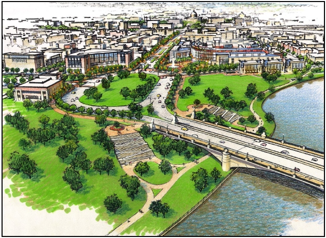 * There will be a large traffic oval at the foot of the new bridge (which will be located to the south of the current bridge), reshaping the intersection of South Capitol Street and Potomac Avenue. (The ballpark's Home Plate Gate and entrance promenade will be the northeast edge of the oval.)
* The top headline is that the new Douglass Bridge is apparently going to be an arched bascule design (like the Memorial Bridge), with an opening span to allow for larger vessels to sail through.
* There will be a large traffic oval at the foot of the new bridge (which will be located to the south of the current bridge), reshaping the intersection of South Capitol Street and Potomac Avenue. (The ballpark's Home Plate Gate and entrance promenade will be the northeast edge of the oval.)* The intersection of South Capitol Street and M Street will become an at-grade intersection (no more underpass for through traffic).
* There will be modifications to South Capitol's interchange with the SE/SW Freeway. They aren't specified in this document, but based on my previous readings of the Draft EIS, I believe the final design will remove the existing ramp that begins at I Street with an at-grade intersection underneath the freeway that would have two left-turn lanes to a new ramp. With the removal of the existing ramp to I-395, the intersection at South Capitol and I would also be reconfigured.
* The northern section of South Capitol Street will match the reconfigured portion between N Street and Potomac Avenue, as a six-lane boulevard with a median and wide sidewalks.
* They expect to get a Record of Decision on the Final EIS from the Feds this fall. There's nothing in this document about a start date.
(Hopefully I'll find out more about the final EIS at Tuesday's ANC 6B meeting, so look for additional details on all of this in the coming days.)
As for the 11th Street Bridges, the file says that a demolition contract will be awarded this month for the decommissioned ramps to and from RFK, with the work expected to take place this spring. As for the big work to reconstruct the bridges, the city expects to choose a design/build team and have a contract with them by June 1, with the entire project slated to be completed by the end of 2013.
The PDF also has quick updates on the Anacostia Streetcar Project, the MLK Great Streets Initiative, the Anacostia Riverwalk Trail, the Parkside Pedestrian Bridge in Ward 7, and a new traffic circle at Pennsylvania and Potomac avenues. It's also got some good general bullet points on the South Capitol and 11th Street projects if you haven't been following up to now. I just hope you have a high-speed connection to download the entire 28-MB file. Otherwise, go get some lunch.
UPDATE: I've taken a little time to give both my South Capitol Street and Douglass Bridge pages a makeover with the new information (and boy, they needed it)--there's now some graphics pinched from the Draft EIS that do a better job explaining what the future plans are. I'd also suggest reading the executive summary of the 2008 Draft EIS, with the knowledge that most of the Design Alternative #2 options apparently have been chosen for the final design. It's a fair amount of detail, but worth it if you want to know how the project has reached its current state, and what's coming in the future. As I said, more to come as the city briefs neighborhoods and groups on the final EIS.
|
Comments (0)
More posts:
Douglass Bridge, streetcars, Traffic Issues
|
251 Posts:
Go to Page: 1 | 2 | 3 | 4 | 5 | 6 | 7 | 8 | 9 | 10 ... 26
Search JDLand Blog Posts by Date or Category
Go to Page: 1 | 2 | 3 | 4 | 5 | 6 | 7 | 8 | 9 | 10 ... 26
Search JDLand Blog Posts by Date or Category