
|
| |||||||||||||||||||

|
Please note that JDLand is no longer being updated.
peek >>
Near Southeast DC Past News Items: Douglass Bridge

|
See JDLand's Douglass Bridge Project Page
for Photos, History, and Details |
- Full Neighborhood Development MapThere's a lot more than just the projects listed here. See the complete map of completed, underway, and proposed projects all across the neighborhood.
- What's New This YearA quick look at what's arrived or been announced since the end of the 2018 baseball season.
- Food Options, Now and Coming SoonThere's now plenty of food options in the neighborhood. Click to see what's here, and what's coming.
![-]()
- Anacostia RiverwalkA bridge between Teague and Yards Parks is part of the planned 20-mile Anacostia Riverwalk multi-use trail along the east and west banks of the Anacostia River.
![-]()
- Virginia Ave. Tunnel ExpansionConstruction underway in 2015 to expand the 106-year-old tunnel to allow for a second track and double-height cars. Expected completion 2018.
![-]()
- Rail and Bus Times
Get real time data for the Navy Yard subway, Circulator, Bikeshare, and bus lines, plus additional transit information. - Rail and Bus Times
Get real time data for the Navy Yard subway, Circulator, Bikeshare, and bus lines, plus additional transit information. - Canal ParkThree-block park on the site of the old Washington Canal. Construction begun in spring 2011, opened Nov. 16, 2012.
![-]()
- Nationals Park21-acre site, 41,000-seat ballpark, construction begun May 2006, Opening Day March 30, 2008.
![-]()
- Washington Navy YardHeadquarters of the Naval District Washington, established in 1799.
![-]()
- Yards Park5.5-acre park on the banks of the Anacostia. First phase completed September 2010.
![-]()
- Van Ness Elementary SchoolDC Public School, closed in 2006, but reopening in stages beginning in 2015.
![-]()
- Agora/Whole Foods336-unit apartment building at 800 New Jersey Ave., SE. Construction begun June 2014, move-ins underway early 2018. Whole Foods expected to open in late 2018.
![-]()
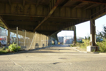
- New Douglass BridgeConstruction underway in early 2018 on the replacement for the current South Capitol Street Bridge. Completion expected in 2021.
![-]()
- 1221 Van290-unit residential building with 26,000 sf retail. Underway late 2015, completed early 2018.

- NAB HQ/AvidianNew headquarters for National Association of Broadcasters, along with a 163-unit condo building. Construction underway early 2017.

- Yards/Parcel O Residential ProjectsThe Bower, a 138-unit condo building by PN Hoffman, and The Guild, a 190-unit rental building by Forest City on the southeast corner of 4th and Tingey. Underway fall 2016, delivery 2018.

- New DC Water HQA wrap-around six-story addition to the existing O Street Pumping Station. Construction underway in 2016, with completion in 2018.

- The Harlow/Square 769N AptsMixed-income rental building with 176 units, including 36 public housing units. Underway early 2017, delivery 2019.

- West Half Residential420-unit project with 65,000 sf retail. Construction underway spring 2017.
![-]()
- Novel South Capitol/2 I St.530ish-unit apartment building in two phases, on old McDonald's site. Construction underway early 2017, completed summer 2019.
![Novel South Capitol]()
- 1250 Half/Envy310 rental units at 1250, 123 condos at Envy, 60,000 square feet of retail. Underway spring 2017.
![-]()
- Parc Riverside Phase II314ish-unit residential building at 1010 Half St., SE, by Toll Bros. Construction underway summer 2017.
![-]()
- 99 M StreetA 224,000-square-foot office building by Skanska for the corner of 1st and M. Underway fall 2015, substantially complete summer 2018. Circa and an unnamed sibling restaurant announced tenants.
![-]()
- The Garrett375-unit rental building at 2nd and I with 13,000 sq ft retail. Construction underway late fall 2017.
![-]()
- Yards/The Estate Apts. and Thompson Hotel270-unit rental building and 227-room Thompson Hotel, with 20,000 sq ft retail total. Construction underway fall 2017.
![-]()
- Meridian on First275-unit residential building, by Paradigm. Construction underway early 2018.
![-]()
- The Maren/71 Potomac264-unit residential building with 12,500 sq ft retail, underway spring 2018. Phase 2 of RiverFront on the Anacostia development.
![-]()
- DC Crossing/Square 696Block bought in 2016 by Tishman Speyer, with plans for 800 apartment units and 44,000 square feet of retail in two phases. Digging underway April 2018.
![DC Crossing]()
- One Hill South Phase 2300ish-unit unnamed sibling building at South Capitol and I. Work underway summer 2018.
![One Hill South Phase 2]()
- New DDOT HQ/250 MNew headquarters for the District Department of Transportation. Underway early 2019.
![New DDOT HQ]()
- 37 L Street Condos11-story, 74-unit condo building west of Half St. Underway early 2019.
![37 L Condos]()
- CSX East Residential/Hotel225ish-unit AC Marriott and two residential buildings planned. Digging underway late summer 2019.
![CSX East Residential/Hotel]()
- 1000 South Capitol Residential224-unit apartment building by Lerner. Underway fall 2019.
![1000 South Capitol Residential]()
- Capper Seniors 2.0Reconstruction of the 160-unit building for low-income seniors that was destroyed by fire in 2018.
![1000 South Capitol Residential]()
- Chemonics HQNew 285,000-sq-ft office building with 14,000 sq ft of retail. Expected delivery 2021.
![1000 South Capitol Residential]()


139 Blog Posts Since 2003
Go to Page: 1 | 2 | 3 | 4 | 5 | 6 | 7 | 8 | 9 | 10 ... 14
Search JDLand Blog Posts by Date or Category
Go to Page: 1 | 2 | 3 | 4 | 5 | 6 | 7 | 8 | 9 | 10 ... 14
Search JDLand Blog Posts by Date or Category
It's been so long since I've written about this that I forgot it was even still in progress, but DDOT has announced two public meetings to present the "preferred alternative" and the Final Environmental Impact Statement for the South Capitol Street Corridor, first on April 26 at Amidon-Bowen Elementary School in SW and then two days later at Savoy Elementary School in SE. This is the long-term study of how to improve South Capitol Street on both sides of the Anacostia River to better address safety, traffic, pedestrian, and streetscape issues, and includes the construction of a new Frederick Douglass Bridge.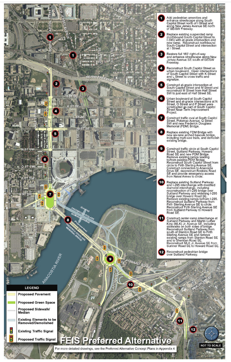 * Add "pedestrian amenities" and enhance the streetcape along South Capitol north of I and along New Jersey Avenue SE north of the freeway.
If you are interested in this subject, there is more verbiage and documentation accompanying the plans than you could ever dream of. (Traffic studies! Environmental consequences! Technical reports!) And I've written a lot about the process, which began more than a decade ago with other studies before the EIS got underway. And I'm sure there will be posts on other blogs delving more specifically into portions of the plans. But, since most people probably want to know "what does this mean for me?", you can see this graphic (from the 224-MB chapter 2 of the FEIS) giving a quick overview of what changes are planned along South Capitol Street if the final EIS is signed off on (and, more importantly, if funding is secured). The short version, for the west side of the Anacostia:
* Add "pedestrian amenities" and enhance the streetcape along South Capitol north of I and along New Jersey Avenue SE north of the freeway.* Replace the existing ramp to the freeway from South Capitol and I with an at-grade intersection. (This would be a left turn onto a ramp to the freeway from under the freeway, near the current Nats HH economy parking lot.)
* Bring New Jersey Avenue SE back to a 160-foot full right-of-way, and add streetscape enhancements.
* "Reconstruct South Capitol Street as an urban boulevard." This means bringing M Street up to an "at-grade" intersection (no more tunnel), and would include new signalized at-grade intersections to allow traffic to cross South Capitol on K and L streets. (M Street would also get reconstructed between the Halfs [SE and SW].) The section of South Capitol north of M would have the same streetscape that the south portion received during its 2007/08 makeover, with wide sidewalks and a tree-lined median.
* Build a traffic oval at South Capitol, Potomac, Q, as the gateway to a new arched bascule-design Douglass Bridge that would have wide "multi-use trails" (i.e., sidewalks!) in both directions. The existing bridge would be demolished, after the new bridge is built somewhat downriver of the current location.
The Executive Summary (220 MB PDF) gives a good overview of the FEIS and preferred alternative (as it should!), but I also suggest wandering through the Chapter 2: Alternatives section, especially if you came to the neighborhood or JDLand after 2008 and didn't get to follow along during the EIS process, or if you're interested in the additional plans for east of the river, which I'm going to leave to others to discuss. My previous posts on all of this may be of interest as well. If you're wanting to see some of the earlier studies referenced in the FEIS, there are links to them at the top of my South Capitol Street project page.
How much would this all cost? The preferred alternative is priced in this final EIS at $806 million (not billion! yeesh) in FY 2014 dollars. (New bridges are expensive, you know.)
(I know that this is a very quick overview of a big study and plan, but there will be plenty of time to talk more about it, especially with the upcoming public meetings.)
|
Comments (1)
|
There's nothing about this on the DDOT web site yet, but WTOP is reporting that "serious structural repairs" are required to the South Capitol Street/Douglass Bridge, and that there will be overnight closures starting tomorrow (Wednesday, Sept. 15), and that the bridge will be completely closed this weekend, from 9 pm Friday, Sept. 17, through 5 am Monday, Sept. 20. The repairs are being done to the "pins and hangers", which are "essentially the pieces that hold the bridge together." The overnight closures are scheduled for every night from Sept. 15/16 through Sept. 29/30 -- see the complete list for more details.
|
Comments (0)
More posts:
South Capitol St., Douglass Bridge
|
From DDOT: "The District Department of Transportation (DDOT) is scheduled to begin necessary repairs on the Frederick Douglass Memorial Bridge (also known as the South Capitol Street Bridge) beginning on Saturday, May 8. Due to the nature of the repairs, traffic loads will be restricted to 10 tons. Trucks meeting the new loading requirement will continue the current restrictions with access to the center lanes only.
"Trucks and buses that exceed 10 tons will be rerouted to alternate routes. See attached map for recommended detours. Detour information will be posted to static and portable message boards along the detour routes. The detours will be in effect beginning Saturday, May 8 at 9 p.m. It is estimated that the detours will remain in place until September 1.
"The majority of the work will take place during off-peak hours, from 9 a.m. to 3 p.m. and nighttime from 9 p.m. to 5:30 a.m. Temporary lanes closures will be in effect during working hours with a single lane remaining open in each direction.
"Additional work will be conducted beneath the bridge as well with minimum or no impact on the vehicular and pedestrian traffic on the bridge. The project is part of the ongoing inspection and maintenance routine for the bridge that began in 2007."
(Here's a stroll down memory lane if you want to see what happened the last time DDOT did a lot of work on the Douglass Bridge.)
Someday there will be a new Douglass Bridge, but not anytime soon, it would seem.
(UPDATED the title of this entry, because I can't count.)
|
Comments (0)
More posts:
Douglass Bridge, Traffic Issues
|
From DDOT, some closures and road work this weekend that might be of interest:
* "DDOT is scheduled to close the Frederick Douglass Memorial Bridge (aka South Capitol Street Bridge) for routine testing, from 4 am to approximately 9 am, on Sunday, May 2, 2010. During normal opening and closing operations, the swing span is lowered and then turned or "swung" around in order to allow water traffic to pass. Crews test the swing span each month to ensure it operates properly and make any necessary repairs. The bridge will be reopened to traffic as soon as the test opening and related repairs are completed. In most cases the work is completed ahead of schedule."
* "On Sunday, May 2, from 6 am to 4 pm, contractors for DDOT may stop traffic for five minutes at a time on the 11th Street Bridge, related ramps and portions of the Southeast-Southwest Freeway, to install traffic counting devices in various locations for the 11th Street Bridge Project. The work involves temporarily installing tubing across the traffic lanes and count machines off the adjacent shoulder. Traffic may be briefly stopped with the aid of District Traffic Safety Officers as needed to protect contractors at each location." See the press release for the list of work zones tied to this.
There's also information on road work for the Case Bridge and the closure of Chain Bridge, but those are outside my jurisdiction!
|
Comments (0)
More posts:
11th Street Bridges, Douglass Bridge, Traffic Issues
|
From DDOT: "The District Department of Transportation (DDOT) is advising drivers and pedestrians that the Frederick Douglass Memorial Bridge (aka South Capitol Street Bridge) will be closed to traffic for up to 2 hours tomorrow morning, Thursday, April 8, 2010. At the request of the United States Coast Guard, DDOT will open the swing span of the bridge at 10 am, to allow for the safe passage of a vessel. It is anticipated the swing span will be closed again by 12 pm and the bridge will reopen to traffic.
"To avoid delays drivers should use an alternate river crossing, including the 11th Street, Sousa (Pennsylvania Avenue) and Whitney Young Memorial (East Capitol Street) bridges."
|
Comments (0)
More posts:
Douglass Bridge, Traffic Issues
|
* The Douglass Bridge (South Capitol Street) will be closed on Sunday morning for its swing span test, from 4 am to approximately 9 am, weather permitting.
* Tickets went on sale this morning at 10 am for the Dave Matthews concert at Nationals Park on July 23--looks like good seats are still available.
* There's been some press over the past few days about the new DDOT web site, especially the "Transportation Access Portal" that gives detailed information about projects around the city, but I was kind of underwhelmed until I found out that the projects of most interest to Near Southeast are under an "Anacostia Waterfront Initiative" tab rather than in the Ward 6 section. There you can find all sorts of project-management details (cost, schedule) for the 11th Street Bridges, the new Douglass Bridge (coming in 2018!), and even the RFK ramp demolition.
*And, in the gosh-why-would-you-think-I-was-killing-time-on-a-Friday-afternoon department, a shot of what the 1000 block of K THIRD Street SE would look like if it were in Mr. Roger's Neighborhood (see large version):

* Plus, I think I have some cool items on the way next week. Fingers crossed.
* UPDATE: Shoot, I knew there was something else I meant to include: Minutes and materials from the last Lower 8th Street visioning session. A report will be submitted to the Office of Planning.
|
Comments (0)
|
 Considering what it portended for the forgotten little patch of land I had been blogging about for the previous 20 months, this post of mine late in the evening on Sept. 21, 2004 was pretty understated: "Baseball coming to Near Southeast? 'District officials disclosed plans yesterday to build a publicly financed stadium costing more than $400 million on the Anacostia waterfront near South Capitol Street, amid growing signs that Major League Baseball will attempt to move the Montreal Expos to Washington.' It doesn't mean that baseball in DC is a done deal, or that the Near Southeast site is a done deal, but it's a very interesting decision, and one that would have a huge impact on Near Southeast if it were to happen."
 Yeah, kind of!
 Late the next day, I went out and took a set of photos throughout the 21 acres that would eventually become home to Nationals Park, knowing it was important to get a bunch of "before" photos should this stadium actually come to pass. This was in the days when my photo-taking was pretty much limited to firing my little point-and-shoot digital camera from behind the wheel while I drove around the neighborhood, having not quite yet worked up the bravery to get out on foot. (Eventually I documented all of the buildings that were demolished to make way for the ballpark, but this Sept. 22 excursion marks for me official start of what would become an all-consuming project for me over the next four years.)
It wasn't until the next week that it was all made official, that the Expos were coming to town and that the city would pursue building a new stadium in Near Southeast. And the reality of the ballpark didn't truly come to pass until that marathon city council session in February 2006 that first voted down then finally ratified the stadium lease agreement (signed by MLB the next month), followed two days later by the court ruling allowing the eminent domain seizure of the land for the ballpark to move forward. Demolitions began in May 2006, and the construction was completed on time for the official opener on March 30, 2008.
 To look at not only the Sept. 22 ballpark-area photos but also a batch I took mainly around the Cappers footprint a few days earlier is to be reminded yet again of how much change has come to this area in the same amount of time that many people, say, pay off a new car. It's almost jarring to catch glimpses in these shots of the old South Capitol Street viaduct (demolished in July 2007) that in many ways was such a symbol of the old Near Southeast--how it walled the neighborhood off from Southwest, and how it helped perpetuate the area's overgrown industrial feeling, while allowing commuters to blow past it all without really having to look at it.
It's going to be a while before big-time development resumes in the area (just like everywhere else in the city/region/country), but that doesn't make the changes that have already happened to this formerly forgotten little spot a mile south of the U.S. Capitol any less striking to look at.
|
Comments (0)
More posts:
Rearview Mirror, Douglass Bridge, Nationals Park
|
(I Tweeted this a week ago, then forgot to ever post it here.) From the WashBizJournal: "Florida Rock Properties Inc. is on the market for a joint venture partner to help develop its much-anticipated 1.1-million square foot project, which will put retail, office space and a waterfront plaza on the land across from Nationals Park." My RiverFront page has scads of renderings, showing the designs and planned phases; the initial plans were to construct the office building and public plaza on the east end of the site (by Diamond Teague Park) first; the later phases can't be built until the new Douglass Bridge is constructed and the old one demolished.
|
Comments (0)
More posts:
Florida Rock, Douglass Bridge, Teague Park
|
Catching up from a few days of slacking:
* Today's Washington Business Journal (subscribers only) reports that the city is "considering" using 225 Virginia Ave. (the old Post Plant) as the new home for Child and Family Services, now that they've decided not to move the agency to a new development at Benning Station. The city continues to pay $6 million a year in rent on the 420,000-sq-ft building, though tried a request for proposals last year to see about a sublease or sale of the property (but apparently didn't get much interest). I wonder how much the city would have to spend the rejigger the very warehouse-y building into the 180,000 sq ft of office space needed by CFSA.
* From the Fredericksburg Free-Lance Star, a story that Prince William County is spending $225,000 to look at passenger ferry service up the Potomac: "It will conduct test boat runs on May 4, 5 and 6 from stops at Prince William marinas at Quantico, Dumfries and Occoquan to Fort Belvoir, Alexandria and the Washington Navy Yard. The test boat will be a catamaran that seats 149." (I assume they'd want to use the dock under construction at Diamond Teague Park, but there's no specifics.)
* On Wednesday evening, the Post reported (though the article is no longer on the web site) that the city had informed Metro--in the middle of a game!--that it would no longer pay the $27,000-an-hour cost of keeping the subway open if games at Nationals Park ran late because of extra innings or rain delays. By the next morning, the city had changed its mind.
* The Douglass Bridge will be closed Sunday (4/26) from 5am to approximately 10am for the monthly swing span test.
|
Comments (0)
More posts:
225 Virginia/Old Post Plant/200 I, Metro/WMATA, Douglass Bridge, Nationals Park, Teague Park, Traffic Issues, Water Taxis/Riverboats
|
Been kind of a nice few days here without much news, so now I'm having to force myself back into the routine. I'll start small: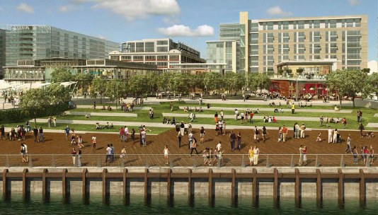 * The agenda for Monday night's ANC 6D meeting is posted, and it includes a vote on the Phase 2 designs of the Yards Park that were discussed at last week's special meeting. I've also now added a bunch of those Phase 2 renderings to my Yards Park page. Other items on the ANC 6D agenda are about Southwest subjects, though I should note that the National Marathon on March 21 (which they'll be discussing) will be coming across the Douglass Bridge, briefly using South Capitol Street until it turns west on P Street.
* An update to the post about the new houses released at Capitol Quarter: EYA tells me that the houses released are spread throughout the development: 421 L Street, under construction and expected to be ready in April (listed for $720,340 on the EYA "Move In Now" list), two houses in the block just to the north (expected to be ready in the fall), and four houses in the block bounded by I/Virginia, Fifth, Fourth, and K that could be ready by the end of the year. On all of these blocks the reservations placed by homeowners over the past few years have now been converted to contracts; that is expected to happen for the final Phase 1 block (between Third and Fourth and Virginia and I) later this year.
* The agenda for Monday night's ANC 6D meeting is posted, and it includes a vote on the Phase 2 designs of the Yards Park that were discussed at last week's special meeting. I've also now added a bunch of those Phase 2 renderings to my Yards Park page. Other items on the ANC 6D agenda are about Southwest subjects, though I should note that the National Marathon on March 21 (which they'll be discussing) will be coming across the Douglass Bridge, briefly using South Capitol Street until it turns west on P Street.There's also an agenda item about a BZA application for 1101 South Capitol St., SW, which was the old KFC. This is a good opportunity for me to mention that, with two blogs about Southwest now in full flight, I'm going back to my original boundaries, which old-timers will remember stopped in the median of South Capitol Street, which is where Southeast ends and Southwest begins. I'm lucky enough to be watching a neighborhood that has probably the firmest boundaries of any in the city, so I'm going to respect them!
* City budget season is nearly upon us. I've added to my calendar a partial list of dates for FY08-09 oversight and FY10 budget hearings, for agencies that have the most bearing on Near Southeast. Check the DC Council web site for the full list.
|
Comments (0)
More posts:
ANC News, Capper, Capitol Quarter, meetings, Douglass Bridge, The Yards, Yards Park, zoning
|
139 Posts:
Go to Page: 1 | 2 | 3 | 4 | 5 | 6 | 7 | 8 | 9 | 10 ... 14
Search JDLand Blog Posts by Date or Category
Go to Page: 1 | 2 | 3 | 4 | 5 | 6 | 7 | 8 | 9 | 10 ... 14
Search JDLand Blog Posts by Date or Category