
|
| |||||||||||||||||||

|
Please note that JDLand is no longer being updated.
peek >>
Near Southeast DC Past News Items: JDLand stuff
- Full Neighborhood Development MapThere's a lot more than just the projects listed here. See the complete map of completed, underway, and proposed projects all across the neighborhood.
- What's New This YearA quick look at what's arrived or been announced since the end of the 2018 baseball season.
- Food Options, Now and Coming SoonThere's now plenty of food options in the neighborhood. Click to see what's here, and what's coming.
![-]()
- Anacostia RiverwalkA bridge between Teague and Yards Parks is part of the planned 20-mile Anacostia Riverwalk multi-use trail along the east and west banks of the Anacostia River.
![-]()
- Virginia Ave. Tunnel ExpansionConstruction underway in 2015 to expand the 106-year-old tunnel to allow for a second track and double-height cars. Expected completion 2018.
![-]()
- Rail and Bus Times
Get real time data for the Navy Yard subway, Circulator, Bikeshare, and bus lines, plus additional transit information. - Rail and Bus Times
Get real time data for the Navy Yard subway, Circulator, Bikeshare, and bus lines, plus additional transit information. - Canal ParkThree-block park on the site of the old Washington Canal. Construction begun in spring 2011, opened Nov. 16, 2012.
![-]()
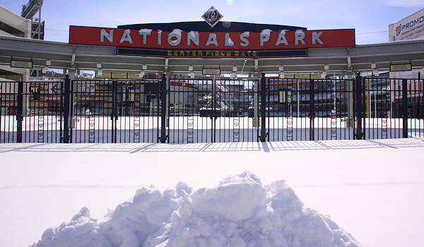
- Nationals Park21-acre site, 41,000-seat ballpark, construction begun May 2006, Opening Day March 30, 2008.
![-]()
- Washington Navy YardHeadquarters of the Naval District Washington, established in 1799.
![-]()
- Yards Park5.5-acre park on the banks of the Anacostia. First phase completed September 2010.
![-]()
- Van Ness Elementary SchoolDC Public School, closed in 2006, but reopening in stages beginning in 2015.
![-]()
- Agora/Whole Foods336-unit apartment building at 800 New Jersey Ave., SE. Construction begun June 2014, move-ins underway early 2018. Whole Foods expected to open in late 2018.
![-]()
- New Douglass BridgeConstruction underway in early 2018 on the replacement for the current South Capitol Street Bridge. Completion expected in 2021.
![-]()
- 1221 Van290-unit residential building with 26,000 sf retail. Underway late 2015, completed early 2018.

- NAB HQ/AvidianNew headquarters for National Association of Broadcasters, along with a 163-unit condo building. Construction underway early 2017.

- Yards/Parcel O Residential ProjectsThe Bower, a 138-unit condo building by PN Hoffman, and The Guild, a 190-unit rental building by Forest City on the southeast corner of 4th and Tingey. Underway fall 2016, delivery 2018.

- New DC Water HQA wrap-around six-story addition to the existing O Street Pumping Station. Construction underway in 2016, with completion in 2018.

- The Harlow/Square 769N AptsMixed-income rental building with 176 units, including 36 public housing units. Underway early 2017, delivery 2019.

- West Half Residential420-unit project with 65,000 sf retail. Construction underway spring 2017.
![-]()
- Novel South Capitol/2 I St.530ish-unit apartment building in two phases, on old McDonald's site. Construction underway early 2017, completed summer 2019.
![Novel South Capitol]()
- 1250 Half/Envy310 rental units at 1250, 123 condos at Envy, 60,000 square feet of retail. Underway spring 2017.
![-]()
- Parc Riverside Phase II314ish-unit residential building at 1010 Half St., SE, by Toll Bros. Construction underway summer 2017.
![-]()
- 99 M StreetA 224,000-square-foot office building by Skanska for the corner of 1st and M. Underway fall 2015, substantially complete summer 2018. Circa and an unnamed sibling restaurant announced tenants.
![-]()
- The Garrett375-unit rental building at 2nd and I with 13,000 sq ft retail. Construction underway late fall 2017.
![-]()
- Yards/The Estate Apts. and Thompson Hotel270-unit rental building and 227-room Thompson Hotel, with 20,000 sq ft retail total. Construction underway fall 2017.
![-]()
- Meridian on First275-unit residential building, by Paradigm. Construction underway early 2018.
![-]()
- The Maren/71 Potomac264-unit residential building with 12,500 sq ft retail, underway spring 2018. Phase 2 of RiverFront on the Anacostia development.
![-]()
- DC Crossing/Square 696Block bought in 2016 by Tishman Speyer, with plans for 800 apartment units and 44,000 square feet of retail in two phases. Digging underway April 2018.
![DC Crossing]()
- One Hill South Phase 2300ish-unit unnamed sibling building at South Capitol and I. Work underway summer 2018.
![One Hill South Phase 2]()
- New DDOT HQ/250 MNew headquarters for the District Department of Transportation. Underway early 2019.
![New DDOT HQ]()
- 37 L Street Condos11-story, 74-unit condo building west of Half St. Underway early 2019.
![37 L Condos]()
- CSX East Residential/Hotel225ish-unit AC Marriott and two residential buildings planned. Digging underway late summer 2019.
![CSX East Residential/Hotel]()
- 1000 South Capitol Residential224-unit apartment building by Lerner. Underway fall 2019.
![1000 South Capitol Residential]()
- Capper Seniors 2.0Reconstruction of the 160-unit building for low-income seniors that was destroyed by fire in 2018.
![1000 South Capitol Residential]()
- Chemonics HQNew 285,000-sq-ft office building with 14,000 sq ft of retail. Expected delivery 2021.
![1000 South Capitol Residential]()


It's time once again for me to take a step back from the minute-by-minute piecemeal nature of news blogging to summarize all that's been going on in Near Southeast over the past 12 months, as well as to make some not-legally-binding guesses about the near future. Yes, it's my 2011 State of the Hood, and admittedly, like most addresses of this kind, it's not an essay of soaring prose, but more of a laundry list to help readers catch up with the the big milestones, especially those folks who don't obsessively follow every twist and turn by closely reading blogs that obsessively follow every twist and turn.
I don't want to give away too much (just read it!), but the theme is similar to what the neighborhood saw in 2009: there still haven't been any big non-publically funded holes in the ground dug since 2008, but the residential population continues to grow, office leases are picking up, stalled projects re-started, and the Yards Park's many events will be bringing lots of visitors to the neighborhood. (That big building where the Nationals play might continue to draw some folks, too, even in a year that will be mostly Strasburg-free but may still become Werth-y of attendance.)
You'll see the latest residential occupancy numbers (*spoiler*: buildings are almost all full up), lists of all the projects underway and completed, a reminder that new retail offerings aren't completely unheard of, and other highlights and lowlights of the year (9th Most Dangerous Neighborhood? Really?). It wraps up with a look forward, with the projects that are said to be starting in 2011, along with other milestones that might be in the offing. In other words, it's not short.
Like a batty old relative pulling out the photo albums for the umpteenth time, I'll take a moment to mark today as the eight-year anniversary of my tracking the changes that were starting to take place south of the freeway. The 63 photos I took while Mr. JDLand drove me around aren't a complete archive of every building in the neighborhood at that time, because frankly all I was doing that day was getting a few shots for myself and not planning the launch of an obsessive compulsive project that would suck up almost all of my free time and energy for years to come. But I came home and put them on my web site so my father could see them, made up a page with some links so I could easily go back to sites to check for updates, and off we went.
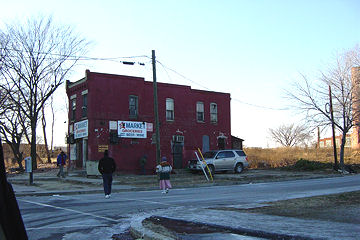
And now maybe it's just as noteworthy to mark Jan. 19, 2003 as the day I took the shot of the Little Red Building standing alone, since that's become the somewhat iconic shot of where the neighborhood was compared to what it was about to become.
Anyway, it's been quite a ride for eight years, with a lot of words and a lot pictures (about 50,000 of them), and I hope that people are continuing to find the site useful and interesting. Thanks for reading, commenting, and sending me news and tips! Hopefully 2011 will be a bounty of news and happenings.
[PS: Is it a sign of a marriage that's getting long in the tooth that I swore the anniversary was actually tomorrow until I saw the "Today in (Recent) Near Southeast History" box on the right side of the home page? So--oops--I guess my State of the Hood is going to be posted on my eight-year-and-one-day anniversary. And I'll also note that today is not the actual JDLand.com anniversary, because I've had my own web site since late 1994 and bought the JDLand domain name in 1996. Old-timers may remember that I didn't even give my Near Southeast stuff the main JDLand.com URL until 2007.]
|
Comments (0)
More posts:
Rearview Mirror, JDLand stuff
|
After the rush of public meetings over the past few weeks, it looks like we're now settling down into Holiday Mode, i.e., not much news, and I'll be taking the opportunity to take a bit of a break from JDLand. If there's anything big, I'll post it, of course, and I doubt I'll go completely silent over on Twitter, but at this point I'm expecting that things will be pretty quiet around here until after New Year's. (That will be when every other blog on the planet does a year-end roundup, but I always save that for my State of the Hood post in mid-January.)
So, Happy Holidays to all, travel safely if you're going over the river and through the woods to Grandma's, and enjoy all the tidings of the season.
|
Comments (0)
More posts:
JDLand stuff
|
I read a few days ago about how the New York Daily News is using Foursquare to drive mobile users to its vast archive of historical NYC images, and I started thinking about my own sightly-less-vast archive of photos I've taken of Near Southeast since 2000, and what I could do with them in a mobile-y kind of way. I figured that what people would be most interested in would be to see what a certain spot looked like before all of the redevelopment started happening. And wouldn't be neat if you didn't have to input your location, but if it was determined via your phone's GPS?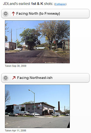 So I threw something together, delving for the first time into both HTML5 and the still-in-alpha JQueryMobile, and it seems to actually work, at least on newer smartphones, though I make no guarantees. (Haven't tried it on older ones.)
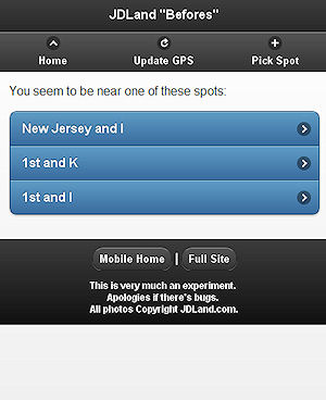
So I threw something together, delving for the first time into both HTML5 and the still-in-alpha JQueryMobile, and it seems to actually work, at least on newer smartphones, though I make no guarantees. (Haven't tried it on older ones.) How to use it? Stand on a street corner in Near Southeast, then go to jdland.com/here. If your phone has GPS, it will first ask you for permission to access your location data, then will lock on your location and bring up a page showing the oldest photo in my archive for eight compass points at that intersection.
Walk to another intersection, hit "Update GPS," and it'll show you a new set. If you're too far from an intersection, it'll ask you to confirm which one you want.
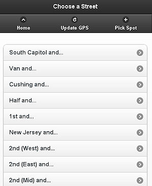
If your phone only uses the less-accurate methods of celltower triangulation or a WiFi signal to determine your approximate location, this app will show you what it thinks the closest intersections are, and you can choose which one to view. Or, if the GPS stuff just isn't working at all, you can browse to the intersection you want to see. (This will be what you'll have to do when you're trying it from your desktop computer, which I know everyone is racing to do right now--note that the pages will only work in Chrome and Firefox but not IE on desktops/laptops.)
It's kind of rudimentary in the display of the photos (yes, it'd be nice to show just one, based on the direction you're looking), but considering I only came up with the notion about 72 hours ago, it's not bad. I also have to ponder how to get these photos via location-awareness to people who are in the neighborhood but don't already know about JDLand, but that will come.
I've written a bit more about the app here--and note that, while I'm calling it an "app," it's just web pages, so it doesn't require a download.
That url again is jdland.com/here, or you can just go to m.jdland.com and follow the link at the top of the page. If you try it out, let me know how it goes. If it doesn't quite work for you, I apologize: it is, after all, something I just tossed together on a whim.
PS: Of course, all my photos since 2000 are available in my full archive whenever you feel like plowing through them, searchable by location and/or date. And maybe when DDOT releases Near Southeast images from its photo archive, I'll add a way to see those as well, but will wait for critical mass on that batch.
|
Comments (0)
More posts:
JDLand stuff
|
I mention this from time to time, but it's worth bringing up again. Any advertising that you see on JDLand should in no way be construed as any sort of endorsement by me or the site of any product or candidate. My ads are served through Google Ads, and I have no direct contact with any advertisers nor even know what ads readers are necessarily seeing (given Google's high-quality algorithms). Just in case anyone is thinking differently....
|
Comments (0)
More posts:
JDLand stuff
|
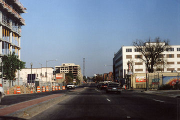 While I officially date the start of my blogging about Near Southeast as being January 2003, that was not when I took my first photos around the neighborhood. In the early fall of 2000, I grabbed a camera (a FILM camera!) and drove south of the freeway, around the neighborhood whose name I didn't know, to take some pictures. I had no plan to do anything with them; in fact, the prints quickly got filed away and I didn't even remember having them until I stumbled across them in 2004. The film I used was bad, so many of the shots barely came out. I don't even know exactly what day it was--judging by the color of the trees, it could be late September or early October. But, despite all of that, the 24 photos I took, now 10 years ago, mark the beginning of my very strange and unexpected odyssey.
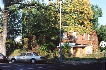 I had spent almost no time below the freeway since buying our house on the south side of Capitol Hill in 1995 (the area's reputation and lack of any amenities gave us no reason to). But in 1999 and 2000, the 3rd Street on-ramp for the freeway was being rebuilt, which forced us to drive to South Capitol Street to get on the westbound freeway. We usually crossed over on K Street to New Jersey, and often got a good laugh when we'd see a sign draped on the southeast corner of the intersection touting a new multiunit residential building "steps from the Capitol." "Dear God, who would ever pay big bucks to live down HERE?" I remember saying to Mr. JDLand on more than one occasion. (So much for vision.)
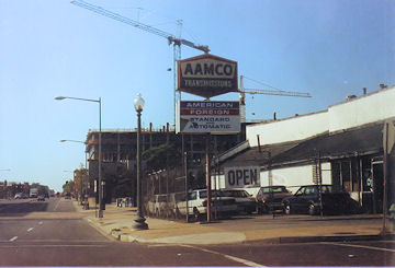 But I was still aware of the changes that were being talked about for the area, along with the first mini-building boom already underway: the construction was almost finished at the Navy Yard to house the NAVSEA operations, and we could see 80 M and 300 M rising up as we drove on the freeway, and I even remember being aware of the streetscape improvements being made to M Street (curbs, bricked medians and crosswalks). So I took a bunch of photos, and promptly forgot about them. And then started the tracking for real in early 2003, this time with a digital camera in hand.
Even though the pictures are pretty cruddy, they're still worth wandering through. Try not to look at the locations, and see if you can figure out where they are; then click on the  icon to see what's happened to these spots in the intervening decade.
icon to see what's happened to these spots in the intervening decade.|
Comments (0)
More posts:
Rearview Mirror, JDLand stuff
|
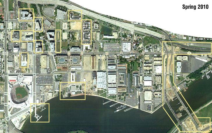 GGW sent out the alert this morning that Google has updated its satellite images of DC, giving us the first overhead images of Near Southeast since Spring 2008. I've added this (somewhat washed out) view to my Satellite Images page, where you can compare it to images from Google and other sources from 1949 (!), 1988, 2002, 2004, 2005, 2006, and 2008. (But you'll also want to visit Google Maps to be able to zoom in on the latest image to get a better view.) Considering that the 2008-10 time frame will be looked back on as the era of the Economic Downtown, there are still plenty of changes to see, including the first phase of Capitol Quarter, the Yards Park and Diamond Teague Park, the construction of the new 11th Street Bridges, and the completion of a number of office and residential buildings north of Nationals Park. (The stadium looks kind of cool from on high as well.) And the lack of schoolbuses at Canal Park!
|
Comments (0)
More posts:
Rearview Mirror, JDLand stuff
|
I don't know what got my adrenaline flowing to finally do this, since I've known for a long time that digging into the vast pool of JDLand content can be pretty unwieldy, but I've now added a "tag cloud" to the right side of the JDLand home page, beneath the calendar. This now gives readers easy access from the home page to the archive of blog posts on the many projects and topics I've written about over the past not-quite-eight years. I also created a separate Tag Cloud page, plus the cloud appears on the main Blog Archive page (where you can also browse my blog posts by date).
I also did some tinkering with the display of archived blog posts to make it easier to browse from page to page, and to get to my project pages. Plus, I finally added the tags for each blog post to my RSS feed. (The tags have appeared in the "More Posts" spot right under each of my entries on the site for a couple years now.)
I don't suppose anyone has to actually look at the cloud to figure out which topic I've written the most about. I'm now up to 1001 posts on it since the first one on Sept. 21, 2004. (Of course, about 400 of those are some variation of "Here are the latest photos I've taken of the construction....")
I won't pretend that my blog tagging has been 100 percent fabulous over the years, and I do tend to err on the side of overtagging posts rather than undertagging (how unlike me!), but I'm digging through the archive in fits and starts to clean it up, and to add new tags as well. The blog is searchable as well, of course, if you still can't find what you're looking for.
|
Comments (0)
More posts:
JDLand stuff
|
Just posted on the blog at UrbanIgloo.com is an interview I recently did with them about my blog and about the current state of Near Southeast/Capitol Riverfront/Navy Yard/Ballpark District/NatsTown/That Area South of the Freeway. There's probably not anything in it that will stun the regular readers of JDLand, but it might be worth a moment or two of your time as you try to come up with ways to fritter away the final days of summer....
|
Comments (0)
More posts:
JDLand stuff
|
Hasn't been much swirling around lately worthy of a full blog post, but here are a couple items so that people don't think I've shut down (though most of them have already been seen on my Twitter feed, aka the "I'm Too Lazy to Blog" feed):
* The light tower at the Yards Park is being installed today, about four weeks in advance of the scheduled grand opening on Sept. 10. I hope to have pictures at some point.
* Greater Greater Washington reports that MPD fanned out around Nationals Park on Wednesday night, ticketing drivers and pedestrians and handing out flyers on safety. GGW also brings up the public meeting held by Tommy Wells back in March about the notion of reworking M Street under the "Complete Streets" principles of creating road networks that work for pedestrians young and old, cyclists, public transportation users, and drivers. by doing things such as adding dedicated bike lanes, creating safer crosswalks, etc. At that meeting, residents of Southwest were unimpressed with the possibilities, but the few Southeast residents in attendance seemed more open to it.
UPDATE: TBD reports that the truck driver in last week's incident is not being cited.
* The Post did a video feature on Hoopernatural, the hula hooping fitness outfit. They are running classes for mixed-levels of hoopiness during August at Canal Park, on Saturday mornings from 10 to 11 am.
* The Capitol Riverfront BID is running a survey to get feedback from residents, workers, and visitors on the types of events the BID holds (concerts, outdoor movies, farmers' market, etc.). Let your feelings be known here.
* While my griping about the bad signage on the SW Freeway (highlighted again by the Post on Thursday) is technically out-of-boundaries, it is on topic to also mention to DDOT that the various blue "services" signs for the South Capitol Street exits on I-395 probably need to get rid of the gas station icons, since the days of having three gas stations right on South Capitol and two within a few blocks to the east are long gone. (But @DDOTDC has put me in a time out after Thursday's flurry of transit-related tweets, which also included this good suggestion from a reader about the need for a left-turn signal on northbound Third Street, SE at Virginia Avenue, for people needing to get onto I-395 southbound.)
* And I stumbled across this study by the New America Foundation about "online-only" news outlets in DC. It counted 61 of them, noting that the "city's oldest local blogs that still command an audience began to spring up in 2003," with JDLand being one of the "original few," thanks to my January 2003 vintage. The piece looks at DCist, GGW, Prince of Petworth, And Now Anacostia, and TBD (though it hadn't yet launched), along with a few nice words about this site. But I have been thinking a lot lately about how I'm an old lady compared to the rest of the DC neighborhood blogosphere, and this article (coming on the heels of my [redacted] birthday) certainly reminded me of it. :-)
|
Comments (0)
More posts:
ANC News, Capitol Riverfront BID, Pedestrian/Cycling Issues, Canal Park, M Street, JDLand stuff, South Capitol St., Traffic Issues, The Yards, Yards Park
|