
|
| |||||||||||||||||||

|
Please note that JDLand is no longer being updated.
peek >>
Near Southeast DC Past News Items: Southeast Blvd.
|
See JDLand's Southeast Blvd. Project Page
for Photos, History, and Details |
- Full Neighborhood Development MapThere's a lot more than just the projects listed here. See the complete map of completed, underway, and proposed projects all across the neighborhood.
- What's New This YearA quick look at what's arrived or been announced since the end of the 2018 baseball season.
- Food Options, Now and Coming SoonThere's now plenty of food options in the neighborhood. Click to see what's here, and what's coming.
![-]()
- Anacostia RiverwalkA bridge between Teague and Yards Parks is part of the planned 20-mile Anacostia Riverwalk multi-use trail along the east and west banks of the Anacostia River.
![-]()
- Virginia Ave. Tunnel ExpansionConstruction underway in 2015 to expand the 106-year-old tunnel to allow for a second track and double-height cars. Expected completion 2018.
![-]()
- Rail and Bus Times
Get real time data for the Navy Yard subway, Circulator, Bikeshare, and bus lines, plus additional transit information. - Rail and Bus Times
Get real time data for the Navy Yard subway, Circulator, Bikeshare, and bus lines, plus additional transit information. - Canal ParkThree-block park on the site of the old Washington Canal. Construction begun in spring 2011, opened Nov. 16, 2012.
![-]()
- Nationals Park21-acre site, 41,000-seat ballpark, construction begun May 2006, Opening Day March 30, 2008.
![-]()
- Washington Navy YardHeadquarters of the Naval District Washington, established in 1799.
![-]()
- Yards Park5.5-acre park on the banks of the Anacostia. First phase completed September 2010.
![-]()
- Van Ness Elementary SchoolDC Public School, closed in 2006, but reopening in stages beginning in 2015.
![-]()
- Agora/Whole Foods336-unit apartment building at 800 New Jersey Ave., SE. Construction begun June 2014, move-ins underway early 2018. Whole Foods expected to open in late 2018.
![-]()
- New Douglass BridgeConstruction underway in early 2018 on the replacement for the current South Capitol Street Bridge. Completion expected in 2021.
![-]()
- 1221 Van290-unit residential building with 26,000 sf retail. Underway late 2015, completed early 2018.

- NAB HQ/AvidianNew headquarters for National Association of Broadcasters, along with a 163-unit condo building. Construction underway early 2017.

- Yards/Parcel O Residential ProjectsThe Bower, a 138-unit condo building by PN Hoffman, and The Guild, a 190-unit rental building by Forest City on the southeast corner of 4th and Tingey. Underway fall 2016, delivery 2018.

- New DC Water HQA wrap-around six-story addition to the existing O Street Pumping Station. Construction underway in 2016, with completion in 2018.

- The Harlow/Square 769N AptsMixed-income rental building with 176 units, including 36 public housing units. Underway early 2017, delivery 2019.

- West Half Residential420-unit project with 65,000 sf retail. Construction underway spring 2017.
![-]()
- Novel South Capitol/2 I St.530ish-unit apartment building in two phases, on old McDonald's site. Construction underway early 2017, completed summer 2019.
![Novel South Capitol]()
- 1250 Half/Envy310 rental units at 1250, 123 condos at Envy, 60,000 square feet of retail. Underway spring 2017.
![-]()
- Parc Riverside Phase II314ish-unit residential building at 1010 Half St., SE, by Toll Bros. Construction underway summer 2017.
![-]()
- 99 M StreetA 224,000-square-foot office building by Skanska for the corner of 1st and M. Underway fall 2015, substantially complete summer 2018. Circa and an unnamed sibling restaurant announced tenants.
![-]()
- The Garrett375-unit rental building at 2nd and I with 13,000 sq ft retail. Construction underway late fall 2017.
![-]()
- Yards/The Estate Apts. and Thompson Hotel270-unit rental building and 227-room Thompson Hotel, with 20,000 sq ft retail total. Construction underway fall 2017.
![-]()
- Meridian on First275-unit residential building, by Paradigm. Construction underway early 2018.
![-]()
- The Maren/71 Potomac264-unit residential building with 12,500 sq ft retail, underway spring 2018. Phase 2 of RiverFront on the Anacostia development.
![-]()
- DC Crossing/Square 696Block bought in 2016 by Tishman Speyer, with plans for 800 apartment units and 44,000 square feet of retail in two phases. Digging underway April 2018.
![DC Crossing]()
- One Hill South Phase 2300ish-unit unnamed sibling building at South Capitol and I. Work underway summer 2018.
![One Hill South Phase 2]()
- New DDOT HQ/250 MNew headquarters for the District Department of Transportation. Underway early 2019.
![New DDOT HQ]()
- 37 L Street Condos11-story, 74-unit condo building west of Half St. Underway early 2019.
![37 L Condos]()
- CSX East Residential/Hotel225ish-unit AC Marriott and two residential buildings planned. Digging underway late summer 2019.
![CSX East Residential/Hotel]()
- 1000 South Capitol Residential224-unit apartment building by Lerner. Underway fall 2019.
![1000 South Capitol Residential]()
- Capper Seniors 2.0Reconstruction of the 160-unit building for low-income seniors that was destroyed by fire in 2018.
![1000 South Capitol Residential]()
- Chemonics HQNew 285,000-sq-ft office building with 14,000 sq ft of retail. Expected delivery 2021.
![1000 South Capitol Residential]()


* CSX NEAR: The Kojo Nnamdi Show hosted on Monday a roundtable on the Virginia Avenue Tunnel project, with David Garber and others. You can listen to it here.
* CSX FAR: Heads will explode, but I will pass along that CSX's J&L Tunnel Modification project has recently won two engineering awards. What is this tunnel? "The J&L Tunnel was constructed in the 1880s as part of the Pittsburgh & Lake Erie Railroad to allow trains to run beneath the former J&L Steel Company’s Pittsburgh Works Southside facility." And what was the project? CSX "increased the vertical clearance of a 130-year-old tunnel running through Pittsburgh’s SouthSide Works, a mixed-use residential and commercial development. CSX worked closely with public officials, local businesses and residents to minimize noise and disruption during construction. Upon completion of the tunnel work, CSX restored trees and plantings, and invested in landscaping improvements that left the overlying Tunnel Park a more usable recreational space."
* HAMPTON: The building permit has been approved for the 168-room Hampton Inn just north of Nats Park. (The shoring permit was approved back in December.)
* THE MASTER PLAN: DDOT has officially released its update to the Anacostia Waterfront Initiative Master Plan. This covers projects like the new Douglass Bridge and South Capitol Street makeover, the Barney Circle/Southeast Boulevard redo, the M Street SE/SW transportation study, the Anacostia Riverwalk Trail, and all other manner of projects and studies for infrastructure updates and improvements in the area. (Though, at 194 pages, maybe the Executive Summary will be a good place to start.) If I were a good blogger, I'd write a big in-depth entry about this, but, well, we know the answer to that these days....
* POLITICS: The Post grades the recent Southwest/Near Southeast Mayoral Forum, and the Hill Rag looks closely at the Ward 6 council race. Primary day is now less than a month away, on April 1. And note that tonight (March 4) there is a forum with the candiates at 7 pm at Westminster Church at 400 I St. SW, and there will be a Ward 6 candidate forum on education issues on Thursday, March 6, at 6:30 pm at Stuart-Hobson Middle School.
* DE-W'ED: Have you noticed that the Curly Ws are gone from various freeway signs? Here's why.
* PASTOR MILLS: Unfortunately, a sad piece of news to mention is that Karen Mills, pastor of the St. Paul's church at 4th and I SE, passed away on Feb. 21. I only met her a few times, but she was a very welcoming and pleasant presence, and condolences go out to her family, friends, and members of the church.
Anything else catching peoples' eyes?
|
Comments (8)
More posts:
CSX/Virginia Ave. Tunnel, hamptoninn, M Street, politics, Southeast Blvd., South Capitol St., Douglass Bridge, Traffic Issues
|
Cleaning out the pending file: * DIG IT: The shoring and sheeting permit has now been approved for the residential building currently known by the spiffy moniker of Parcel N at the Yards, which means that the parking lot on the southwest corner of 4th and Tingey should start being dug up any time now (beyond just the DC Water digging up that's been going on for a while). This building will have 327 residential units and 20,000 square feet of ground-floor retail when completed in either late 2015 or early 2016.
* DIG IT: The shoring and sheeting permit has now been approved for the residential building currently known by the spiffy moniker of Parcel N at the Yards, which means that the parking lot on the southwest corner of 4th and Tingey should start being dug up any time now (beyond just the DC Water digging up that's been going on for a while). This building will have 327 residential units and 20,000 square feet of ground-floor retail when completed in either late 2015 or early 2016.* MMMM, BEER: Bluejacket is going to start offering tours of its brewery, beginning Jan. 31. The offerings range from a free tour with one complimentary taste of a Bluejacket brew to a $22 "tasting tour" to the $75 "Beer and Food Experience Tour." See the web site for more details.
* A REVIEW: Alas, the Post's Tom Sietsema did not have particularly good things to say about the food at the Arsenal (but he did like Bluejacket's brewed offerings).
* ANC VACANCY: The Board of Elections has officially certified the vacancy in 6D02 after Ed Kaminski's resignation, and the wheels are now turning for a special election. Petitions may be picked up at the BOE and circulated until Feb. 3, with challenges to those petitions allowed through Feb. 12. If more than one person successfully makes it through the petition process, an election will be held, most likely at 6D's March business meeting. If only one candidate qualifies, that person automatically fills the vacancy. So, if you're itching to be an ANC commissioner and you live in Capitol Hill Tower, or Velocity, or 909 New Jersey, or across the way in the northeastern sections of Southwest, here's your chance.
* SOUTHEAST BLVD: ANC 6B's Brian Flahaven has posted the commission's draft comments on DDOT's initial plans for the rebuild of Barney Circle and Southeast Blvd. Spoiler: "The committee recommended a number of clarifying changes to the comments including the addition of an opening sentence that conveys the commission’s opposition to the design concepts presented to the community on Nov. 21, 2013. The committee also wanted to make it clear that other stakeholders besides DDOT need to be brought into the project discussion."
|
Comments (1)
More posts:
ANC News, Bluejacket, Restaurants/Nightlife, Southeast Blvd., JDLand stuff, Traffic Issues, The Yards, Arris/Parcel N/Yards
|
 DDOT is hosting another public meeting tonight (Thursday, Nov. 21) on its project to both turn the old sunken portion of the Southeast Freeway into "Southeast Blvd." and also to remake Barney Circle.
 This meeting will "seek community feedback on updated design concepts" that "illustrate ways to transform the Southeast Freeway between 11th Street SE and Barney Circle into a boulevard that integrates with adjacent neighborhoods and provides new connections to the Anacostia River."
The meeting is from 6:30 to 8:30 pm at Payne Elementary School, 1445 C St., SE.
This is a study that I'm actually pretty interested in, but I missed the previous meeting and ensuing discussions owing to my Annus Horribilis, so I can't give you a whole lot of details on how it has all gone up to now. The project web site has the basics, including the presentation slides from the first meeting, and ANC commissioner Kirsten Oldenburg posted 6B's first comments on the concepts back in April.
 Some of the work on Southeast Blvd. has of course already begun, with tons and tons of dirt already having filled in the former underpass beneath 11th Street, so that traffic coming from the freeway will be able to exit to a signalized intersection at 11th. But little work has been done east of 11th, which is good since it's this study that is to determine exactly what that work should be.
Also, if you can't get enough of public meetings on transportation issues, you can also mark your calendar for an upcoming DDOT meeting regarding updates to the Anacostia Waterfront Initiative Transportation Master Plan. It's on Dec. 12 from 6:30 to 8:30 pm at the Capitol Skyline Hotel at South Capitol and I streets, SW.
|
Comments (4)
More posts:
meetings, Southeast Blvd., Traffic Issues
|
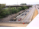
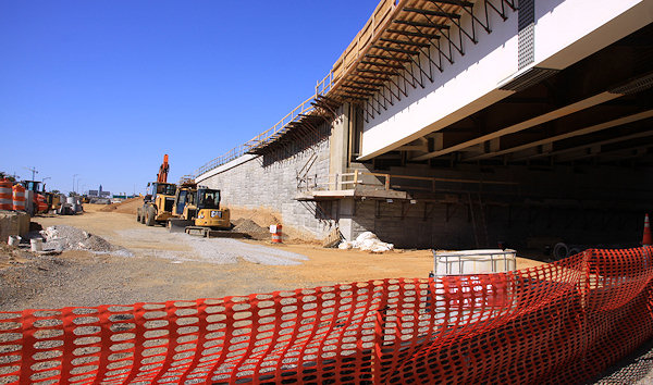
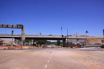
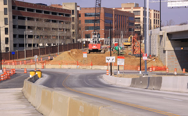
I was otherwise occupied on Sept. 7, the day of the big celebration on the now-completed 11th Street Local Bridge, but I finally wandered down to that neck of the woods a few days ago with my camera to capture the current state of affairs. And one might say that the landscape at 11th and O has changed a bit thanks to this project:
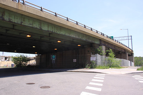
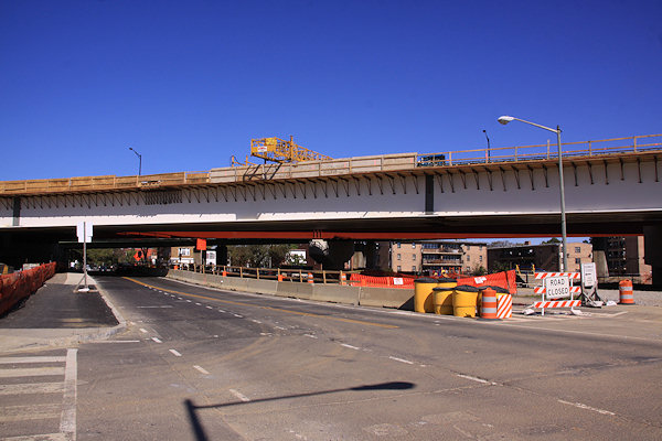
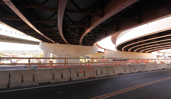
But there's more than just the newly wide open spaces at 11th and O. The girders for the new flyover that will carry traffic from the Southeast Freeway to the outbound I-695 bridge are all now in place; couple that with the demolition earlier this year of the old outbound flyover, and you have a very different vista at 11th and L than what's been there up to now:
(The low height of the flyovers above 11th does make that little stretch a bit claustrophobic, though, especially on foot.)
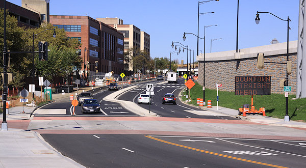
You also now have two-way traffic on 11th between O and M, so that vehicles coming across the local bridge from Anacostia can drive straight north on 11th.
And the dirt-fill-in work for Southeast Blvd. has progressed enough that the west side of 11th at the freeway no longer feels like an overpass, just the regular road.
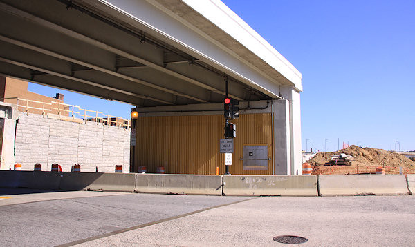
Plus there's also work at 8th Street and Virginia Avenue to create a new on-ramp and also fashion the new exit to Southeast Blvd./11th Street.
If you don't feel like clicking on each of these photos, just head to my 11th Street Bridges and Southeast Blvd. pages to see them alongside a few other new shots. You may also want to dig into my photo archive to check out the before-and-afters at 11th and the freeway, 11th and L, 11th and M, 11th and N, and 11th and O. Though the photos don't quite seem to do the changes justice, especially if you're someone who has walked those blocks of 11th many times over the past few years.
|
Comments (0)
|
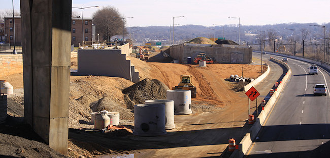
 The showiest demolition in the neighborhood in years is coming to an end, and while I haven't been able to document it in the obsessive-compulsive way I would have liked, I did manage to make it to 11th Street this weekend to see the gator tail-like final remnants of the old flyover to the outbound 11th Street Bridges before it completely comes down.
At the same time, I was able to check out the progress on the filling-in of the sunken eastern portion of the Southeast Freeway to build Southeast Blvd., and dang if they haven't already piled the dirt up so that 11th Street is now level with the "land" just to its west.
Needless to say, I had to create a photo gallery of the remants and the progress, where you'll also see that work is speeding along on the new flyover to the outbound I-695 bridge.


But I wasn't just interested in the tearing down and filling in, so I continued down to O Street, where not only is the 11th Street Local Bridge inching ever closer to getting all of its lanes and pedestrian path opened, but the new asphalt Anacostia Riverwalk Trail path to the river has been laid, which also takes you to the spiffy new landing just completed by the riverside. And from that landing you can see the spiffy new overlooks that reach out onto the old bridge piers from the new local bridge. (For the record, I could have easily sidestepped the construction barrels and ventured onto the overlooks, but I am a good little citizen.)
Lots of images of the new trail, the landing, the bridge, and the surroundings are in a second new photo gallery.


 If these two galleries aren't enough, you might take some time to browse my before-and-afters all the way down 11th Street, from the freeway to L to M to N to O to the river, as nearly four years of construction have altered the vistas from a maze of flyovers and embankments to, well, a completely different maze of flyovers and embankments. (But the new flyovers are a little lower on the horizon, at least.)
I also checked out the other projects that are in various stages these days, from Twelve12 to the Lumber Shed to the leafed-out and fountain-ed Canal Park to the hole in the ground that will be the Park Chelsea.
There's new pictures on each of those pages, but I also couldn't help myself and pulled together a third photo gallery, with photos from those spots and a few others that were particularly photogenic on a particularly photogenic day. (It even includes my very first visit to the footprint of one of the neighborhood's most central locations. Where might that be?)


[A postscript: I truly think Sunday was the most perfect day for taking pictures in the 10-plus years I've been wandering the neighborhood, with the achingly clear deep blue sky perfectly matched with the late-May sun strength and positions. I ended up walking more than eight miles in three separate treks, and came home with a smidge more than 1,000 photos, about 300 of which are now in my photo archive.]
|
Comments (3)
More posts:
11th Street Bridges, Lumber Shed/Yards, photos, riverwalk, Southeast Blvd., The Yards, Parcel A/Yards, Twelve12/Teeter/Yards
|
 With the reconstruction of the old Southeast Freeway east of 8th Street into the new Southeast Blvd., DDOT is running a transportation planning study that is looking how best to integrate this rebuilt stretch of road with the adjacent neighborhoods between 11th Street and Barney Circle. To that end, there is a public meeting about this "opportunity for adaptive reuse" being held this Thursday, Feb. 21, at 6:30 pm at Payne Elementary School at 1445 C St., SE. Representatives of DDOT and the technical team working on Southeast Blvd. will be there to provide details about the study and future plans for the area, as well as to answer questions.
 This would probably be the perfect forum to ask some of the questions that have been posted in the comments here, such as whether the new boulevard will have an intersection with 13th Street, and how the pedestrian/cycling trail planned to be built alongside the boulevard will be handled.
|
Comments (2)
More posts:
meetings, Southeast Blvd., Traffic Issues
|
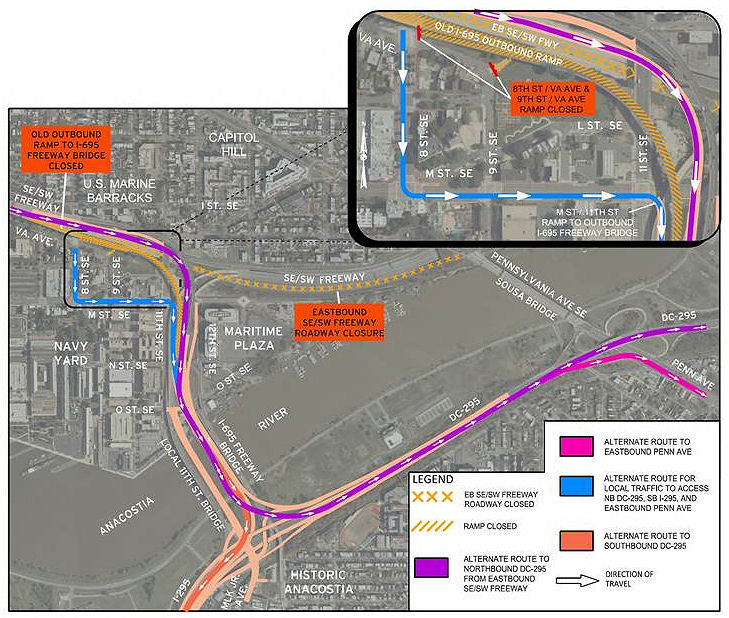 As I wrote a few days back, the portion of the Southeast Freeway between 8th Street SE and Pennsylvania Avenue will be fully closed after the evening rush hour on Thursday, Jan. 31, to both begin work on the new Southeast Blvd. and to demolish the existing outbound flyover ramp and replace it with a new three-lane one.
One thing I didn't mention in that post is that, with these closures Thursday, both the 8th Street SE on-ramp to the outbound I-695 freeway bridge and the 9th Street ramp toward Pennsylvania Avenue will be closed.
As the helpful graphic at right from DDOT shows, if you're wanting to get on I-695 outbound, you'll need to use the ramp on the southeast corner of 11th and M.
Since this closure now makes the Southeast Blvd. project truly seem underway, I've been spurred into an unexpected burst of action, and have created a Southeast Blvd. project page, separate from my recently refreshed 11th Street Bridges page. Right now it's mainly drawings, "before photos," and links to my previous posts on the project, but I will keep it updated throughout the expected 18-to-20-month span of construction:
I also threw together a new 11th Street Bridges Progress Photo Gallery with some new shots from this past weekend, when I traipsed around N and O streets and up on the local bridge for the first time in way too long.

And now I think my guilt over some long-neglected photos is assuaged, at least for a little while.
|
Comments (9)
|
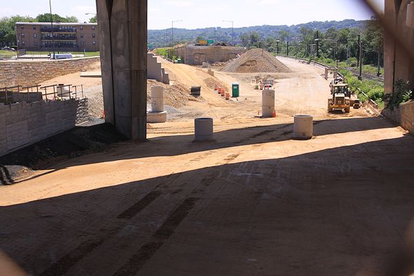
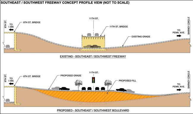
 The next step in converting the sunken portion of the Southeast Freeway between 8th Street SE and Pennsylvania Avenue to the eventual at-grade "Southeast Boulevard" is coming, as DDOT has announced that on Jan. 31, "all eastbound lanes along this stretch will be closed to traffic for approximately 18-20 months while crews fill the roadway to restore it to the local street elevation."
 This will be preceded by for a week or so beginning around noontime on Tuesday, Jan. 22, with the route being reduced to only one lane.
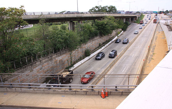
Not only are these closures to allow for the filling-in of much of the old roadway, but also to start construction of bridge piers for "a new bridge over the SE Freeway," which I believe will be the new three-lane flyover ramp from the freeway to the outbound 11th Street Bridge, replacing the current one (seen at top left in the photo).If you're worked up about this closure because you're using the route to Pennsylvania Avenue to then use the left-turn-to-DC295, you should already be using the new exit ramp from the outbound 11th Street Bridge directly to northbound 295 anyway!
 The work of bringing in lots and lots (and lots and lots) of dirt to build up the sunken route has already begun on the old westbound side of the road, as seen in this photo I took earlier this month, when I also updated the before and afters for the 11th Street & not-yet-Southeast-Blvd intersection.
If you haven't been following this project, which is part of the $90 million second phase of the 11th Street Bridges project, the filling-in is so there will be an at-grade signalized intersection at 11th Street, SE. Drivers will arrive at the new intersection from the SE Freeway (or Pennsylvania Avenue) and have the option of getting onto 11th Street, or continuing straight. There will also be a new stretch of 12th Street north of M to Southeast Blvd., so that drivers exiting the 11th Street freeway bridges can continue north across M to the new boulevard, instead of turning left onto M and then right onto 11th.
There is also supposed to be a new pedestrian/cycling trail alongside this new Southeast Blvd., creating another connection between Virginia Avenue Park and Barney Circle than using the currently-ripped-up-by-DC-Water M Street route.
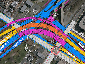
This construction drawing shows all the new intersections, ramps, flyovers, and whatnot for both phases of the project on the west side of the river, if you need some help visualizing.
There are also supposed to be public meetings coming this year as part of studies now underway on how to remake the Barney Circle-not-yet-Southeast-Blvd interchange.
|
Comments (1)
More posts:
11th Street Bridges, Southeast Blvd., Traffic Issues
|
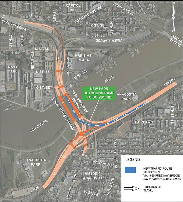 UPDATE, Dec. 19: A tweet from DDOT confirms that the new ramp is "slated to open this afternoon, possibly in time for evening rush hour." UPDATE TO THE UPDATE: According to NBC4's Adam Tuss, the ramp is now open.
Original post: Just out from DDOT, an announcement that the long-awaited ramp from the outbound 11th Street freeway bridges (now known as I-695) to DC-295 northbound is expected to open "on or about December 19." This means that vehicles traveling eastbound on the southeast freeway can now remain on the freeway for their entire trip to DC-295 northbound, instead continuing along the stub of the Southeast Freeway ending at Barney Circle, then traveling across the Sousa Bridge to then endure a nightmare left turn onto DC-295.
Not mentioned in the announcement is whether at the same time the old route to Pennsylvania Avenue will be closed--if it doesn't close the 19th (see Update II below), it will be closing soon, as part of the two-year reconfiguration of that road as "Southeast Boulevard."
{I'm psychic!}
UPDATE: I should also note that, according to the graphic at right, eastbound freeway traffic will start being routed (temporarily!) on the new flyover built during the past few years that will eventually carry inbound traffic; but using it for outbound traffic at this point allows the existing older outbound flyover to be demolished to make way for a new outbound flyover. Photos and additional explanations here and here.
UPDATE II: However, if you're used to getting onto the eastbound freeway and 11th Street Bridges via the ramp at 8th and Virginia, be advised that ramp will close when demolition begins of the old outbound flyover, which is expected to start in late January. And, to answer another lingering question from this post, that's when the eastbound freeway east of 8th will be closed, which also means that the little ramp from 9th and Virginia to the eastbound freeway stub will be closed as well. (This all from @DDOTDC on Twitter.) You'll be able to access the new ramp to DC-295 northbound by getting on eastbound I-695 via the new-ish ramp on the southeast corner of 11th and M; in fact, the entrance lane from that ramp I believe puts you directly in the DC-295 NB exit lane. Or, if you're on the western end of the neighborhood, you can get on the eastbound freeway at South Capitol Street (only in my fever dreams).
|
Comments (7)
More posts:
11th Street Bridges, Southeast Blvd.
|
A release just out from DDOT is announcing that the new ramp from 11th Street SE to the westbound Southeast/Southwest Freeway wll be opening on Thursday, Nov. 29. This means that vehicles from the eastern ends of Capitol Hill and Near Southeast won't have to drive along Virginia Avenue to the 3rd Street SE on-ramp anymore; it will also give easier westbound freeway access to traffic coming inbound on the 11th Street Local Bridge.
Also on Nov. 29, the westbound portion of the sunken SE Freeway between Pennsylvania Avenue/Barney Circle and 8th Street SE will be fully closed, as work continues on creating the new "Southeast Blvd." Drivers heading south on DC-295 who have long exited onto Pennsylvania to go west on the SE/SW Freeway will be directed to use the inbound 11th Street Freeway Bridge.
I wrote a lot about these changes back in September, so I'll just point you to those three posts for additional information and photos, or you can wander through my 11th Street Bridges project page.
|
Comments (4)
More posts:
11th Street Bridges, Southeast Blvd.
|