
|
| |||||||||||||||||||

|
Please note that JDLand is no longer being updated.
peek >>
Near Southeast DC Past News Items: Rearview Mirror
- Full Neighborhood Development MapThere's a lot more than just the projects listed here. See the complete map of completed, underway, and proposed projects all across the neighborhood.
- What's New This YearA quick look at what's arrived or been announced since the end of the 2018 baseball season.
- Food Options, Now and Coming SoonThere's now plenty of food options in the neighborhood. Click to see what's here, and what's coming.
![-]()
- Anacostia RiverwalkA bridge between Teague and Yards Parks is part of the planned 20-mile Anacostia Riverwalk multi-use trail along the east and west banks of the Anacostia River.
![-]()
- Virginia Ave. Tunnel ExpansionConstruction underway in 2015 to expand the 106-year-old tunnel to allow for a second track and double-height cars. Expected completion 2018.
![-]()
- Rail and Bus Times
Get real time data for the Navy Yard subway, Circulator, Bikeshare, and bus lines, plus additional transit information. - Rail and Bus Times
Get real time data for the Navy Yard subway, Circulator, Bikeshare, and bus lines, plus additional transit information. - Canal ParkThree-block park on the site of the old Washington Canal. Construction begun in spring 2011, opened Nov. 16, 2012.
![-]()
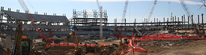
- Nationals Park21-acre site, 41,000-seat ballpark, construction begun May 2006, Opening Day March 30, 2008.
![-]()
- Washington Navy YardHeadquarters of the Naval District Washington, established in 1799.
![-]()
- Yards Park5.5-acre park on the banks of the Anacostia. First phase completed September 2010.
![-]()
- Van Ness Elementary SchoolDC Public School, closed in 2006, but reopening in stages beginning in 2015.
![-]()
- Agora/Whole Foods336-unit apartment building at 800 New Jersey Ave., SE. Construction begun June 2014, move-ins underway early 2018. Whole Foods expected to open in late 2018.
![-]()
- New Douglass BridgeConstruction underway in early 2018 on the replacement for the current South Capitol Street Bridge. Completion expected in 2021.
![-]()
- 1221 Van290-unit residential building with 26,000 sf retail. Underway late 2015, completed early 2018.

- NAB HQ/AvidianNew headquarters for National Association of Broadcasters, along with a 163-unit condo building. Construction underway early 2017.

- Yards/Parcel O Residential ProjectsThe Bower, a 138-unit condo building by PN Hoffman, and The Guild, a 190-unit rental building by Forest City on the southeast corner of 4th and Tingey. Underway fall 2016, delivery 2018.

- New DC Water HQA wrap-around six-story addition to the existing O Street Pumping Station. Construction underway in 2016, with completion in 2018.

- The Harlow/Square 769N AptsMixed-income rental building with 176 units, including 36 public housing units. Underway early 2017, delivery 2019.

- West Half Residential420-unit project with 65,000 sf retail. Construction underway spring 2017.
![-]()
- Novel South Capitol/2 I St.530ish-unit apartment building in two phases, on old McDonald's site. Construction underway early 2017, completed summer 2019.
![Novel South Capitol]()
- 1250 Half/Envy310 rental units at 1250, 123 condos at Envy, 60,000 square feet of retail. Underway spring 2017.
![-]()
- Parc Riverside Phase II314ish-unit residential building at 1010 Half St., SE, by Toll Bros. Construction underway summer 2017.
![-]()
- 99 M StreetA 224,000-square-foot office building by Skanska for the corner of 1st and M. Underway fall 2015, substantially complete summer 2018. Circa and an unnamed sibling restaurant announced tenants.
![-]()
- The Garrett375-unit rental building at 2nd and I with 13,000 sq ft retail. Construction underway late fall 2017.
![-]()
- Yards/The Estate Apts. and Thompson Hotel270-unit rental building and 227-room Thompson Hotel, with 20,000 sq ft retail total. Construction underway fall 2017.
![-]()
- Meridian on First275-unit residential building, by Paradigm. Construction underway early 2018.
![-]()
- The Maren/71 Potomac264-unit residential building with 12,500 sq ft retail, underway spring 2018. Phase 2 of RiverFront on the Anacostia development.
![-]()
- DC Crossing/Square 696Block bought in 2016 by Tishman Speyer, with plans for 800 apartment units and 44,000 square feet of retail in two phases. Digging underway April 2018.
![DC Crossing]()
- One Hill South Phase 2300ish-unit unnamed sibling building at South Capitol and I. Work underway summer 2018.
![One Hill South Phase 2]()
- New DDOT HQ/250 MNew headquarters for the District Department of Transportation. Underway early 2019.
![New DDOT HQ]()
- 37 L Street Condos11-story, 74-unit condo building west of Half St. Underway early 2019.
![37 L Condos]()
- CSX East Residential/Hotel225ish-unit AC Marriott and two residential buildings planned. Digging underway late summer 2019.
![CSX East Residential/Hotel]()
- 1000 South Capitol Residential224-unit apartment building by Lerner. Underway fall 2019.
![1000 South Capitol Residential]()
- Capper Seniors 2.0Reconstruction of the 160-unit building for low-income seniors that was destroyed by fire in 2018.
![1000 South Capitol Residential]()
- Chemonics HQNew 285,000-sq-ft office building with 14,000 sq ft of retail. Expected delivery 2021.
![1000 South Capitol Residential]()


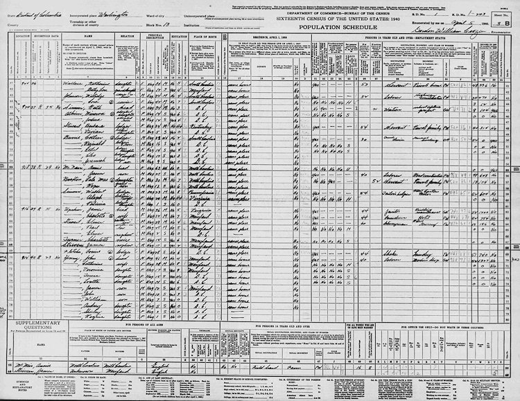 You may or may not be aware that this week the National Archives posted online the 3.8 million pages that made up the 1940 census. They aren't yet searchable by name, but they are browsable by "enumeration district." This means that if you don't mind waiting for huge images to load, you can in essence wander from street to street and find out all manner of information about the people who lived there 72 years ago.
Since I've had a little bit of experience with census digging (I did a lot of my family's geneaology back in the early 2000s, before I began some other project that soon sucked up all my free time), I took a few minutes and found the links to the five enumeration districts that cover Near Southeast, along with the map that shows their locations.
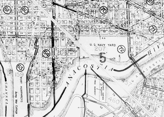 So, if you live in Capitol Quarter, ED 204 covers you (from 2nd to 5th and Virginia to M). ED 203 goes east from 5th to 11th, while ED 205 includes all the blocks between 2nd and South Capitol north of M, for you Velocity/Onyx/CHT/Capitol Yards folks. ED 206 goes from M to the Waterfront and over to what's now the WASA site, while ED 207 covers the Navy Yard, which at that time ran from New Jersey Avenue to 11th. (It's actually funny how those boundaries from 72 years ago do a pretty good job of reflecting how the neighborhood's various sub-areas are still seen today.)
This was more than 10 years before the Cappers were built, but the neighborhood wasn't exactly a rich enclave. Plus, not many houses that were standing in 1940 remain in existence today, so only a few people will get the fun of seeing who actually lived in their house back then. But I thought one or two people might enjoy wandering through the many pages to get a feel for the people who lived in Near Southeast as World War II was looming. (You'll probably want to use the Questions Asked page to guide you across the columns. Note that the street name is written vertically in the first column, with the house number next. And the pages don't always perfectly follow the grid, so you may need to page through much of the ED to find the spot you're looking for. Plus, the image display is really cruddy right now, so using the option to download an entire ED and then browsing with the image viewer on your own computer might be preferable.)
Please post in the comments anything interesting you find--you'll make an old lady historian very happy.
(And I guess I might have to dig up the same information for earlier censuses. Not tonight.)
PS: If you don't live in one of these EDs, you can wander through the city map to find yours.
I usually just toss these out only on Twitter every so often, but after sneaking a peek at my February 10, 2007 photo gallery (thanks to that "This Day In Near Southeast History" box on the JDLand home page), I thought that it merited an actual blog post.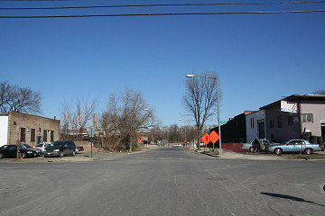
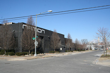
Early 2007 is the optimum time for seeing the last vestiges of the old neighborhood west of New Jersey Avenue juxtaposed with the stampede of new construction. There's a lot of "holes in the sky" where we're now used to seeing 70/100 I, 909 New Jersey, Onyx, 100 M, 55 M, Velocity, and 1015 Half.
And there was this big project underway south of N Street:
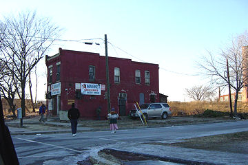
There's even images that surprise me, like seeing the South Capitol Street viaduct again (it was demolished five months later). And, of course, Normandie Liquors still stood alone.
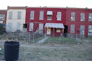
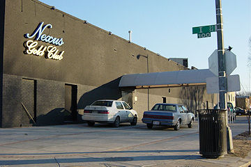
Over the next four months, demolition would clear 25 buildings directly north of the ballpark, including all of the remaining night clubs from the neighborhood's old days (Wet, Edge, Club 55, the Nexus Gold Club, and Nation). Construction would begin on 55 M and Velocity, and 70/100 I, Onyx, and 100 M would come out of the ground. And the US Department of Transportation opened.
There's a lot going on in the neighborhood once again these days, but it'll never be anything like 2007 and 2008. So check out both pages of the gallery, and prepare to be amazed! (Or not.)
UPDATE: It might also be interesting to look at my gallery from one year later, Feb. 10, 2008, to really get a sense of how much things changed in 12 months.
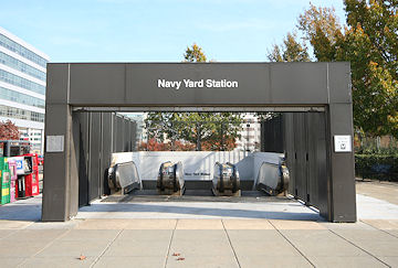 If you're looking for an excuse to have a celebration (and who isn't in the long, seven-day slog between Christmas and New Year's), you can raise a glass on Wednesday to the 20th birthday of the Waterfront, Navy Yard, and Anacostia Metro stations, which opened on Dec. 28, 1991.
Not surprisingly, it was the arrival of DC's subway in Anacostia that was the main focus of opening day celebrations: "At long last, after two decades of planning and delays, site squabbles and legal hurdles, Metro's Green Line came to Anacostia yesterday and Anacostia rolled out a green carpet of welcome," reported the Washington Post.
But, a few days earlier, the Post published a piece focusing on what changes the new Navy Yard station would bring to its surroundings:
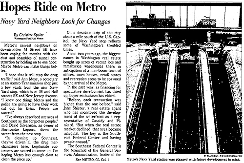 "Metro's newest neighbors on downtrodden M Street SE have been coping for months with the dust and shambles of tunnel construction by holding onto one hope: Maybe Metro can make things better."
"'I hope that it will stop the drug traffic,' said Ann Mose, a secretary at an Aamco Transmission shop just a few yards from the new Navy Yard stop, which is at M and Half streets SE and New Jersey Avenue. 'I know one thing: Metro and the police are going to have their work cut out for them. People are scared.'"
Then, see if this part sounds familiar: "About two years ago, the biggest names in Washington real estate bought up acres of vacant lots and ramshackle warehouses there in anticipation of a mini-boom town of offices, town houses, retail stores and recreation areas to be spawned by the arrival of the Metro. In the past year, as financing for speculative development has dried up, buyer enthusiasm has ebbed."
The article then speaks of the plans to redevelop the Southeast Federal Center with 1 million square feet of office space for 23,000 federal workers at agencies like GSA, the Army Corps of Engineers, the Navy, and perhaps FEMA.
"But today, as Metro cars rumble through test runs on the new extension of the Green Line, those dreams seem obscured by drug traffickers who walk undisturbed up and down M Street, in the shadows of boarded-up buildings that neighbors call crack houses, from which Metro workers solicitously warn visitors to stay away. [...]
"Between that and the subway stop is public housing. Trash piles up on the sidewalk. Hypodermic needles are discarded in open lots.
"'You've got to be something of a visionary to see what this is going to be like in five to 10 years,' GSA administrator Dick Austin said. 'There are a lot of those who are skeptics and say it's not going to happen.... Did you ever see the movie 'Field of Dreams?'"
And, in referencing the commercial developers who had bought up much of the land in the neighborhood, the article says: "Their hopes[...]: that the lackluster waterfront from Buzzard Point to the Washington Navy Yard could be turned into the Tysons Corner of the 21st century."
|
Comments (2)
More posts:
Metro/WMATA, Rearview Mirror
|
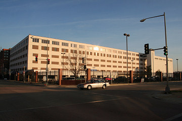 It can be hard to get much information when you're dealing with one of the more cloak-and-dagger-y agencies of the US Government, but word is filtering out that the National Geospatial-Intelligence Agency has begun the BRAC-mandated move of its employees from the windowless fenced-off building at 1st and M SE to its $1.7 billion new Campus East facility in Springfield.
 According to NextGov, the first of NGA's 8,500 employees arrived at their new home in January with more continuing to make the move, and I've confirmed that this includes some employees from the Near Southeast location as well as NGA's other locations in Bethesda, Reston, and Ft. Belvoir. The moves are happening in a staggered fashion, working toward the required "fully operational" date of September 15 in Springfield. (You can see construction photos of the new campus on Flickr, or learn more about the history of NGA via Wikipedia.)
The 1st and M building, known as Building 123 213 in Southeast Federal Center parlance, is the northwestern-most portion of the footprint of The Yards, and the long-term plans for the site are for new office space with ground-floor retail. Perhaps once NGA has completed the move there will be a freer flow of information about the site (if the building will be torn down or used for other purposes in the interim, if the fence will come down, etc.). It also is more than likely that there are other somewhat shadowy outfits operating in this space as well, and I'm not sure whether they're heading for even more shadowy pastures elsewhere during this move.
But the departure of NGA is a step toward replacing the armed encampment one block from Nationals Park with something a bit more welcoming--and I'm sure the building's security folks aren't terribly unhappy about no longer being surrounded by red-clothed hordes (toting cameras! the horror!) 80 days a year. (I will admit to once starting to point a camera at a few of the guards behind the fence--without coming close to squeezing the shutter--just for the fun of showing the people I was with how quickly the guards would reach for their guns.)
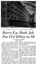 It's not like there's ever been a whole lot of detail about the goings-on on this corner: the Post reported back in 1964 that the CIA moved into the renovated Naval Weapons Plant warehouse in January 1963 with "no announcement, no little ceremony, no welcome-to-the-great-southeast-sector fanfare." There also hadn't been any announcement in November 1961 when the GSA awarded a no-bid contract to get the building renovated.
(Current residents and observers will get a kick out of the Post's 1964 description of the building's surroundings as "liquor stores, run-down shops, a railroad spur, and, right around it, a formidable chain link fence topped by five rows of unfriendly barbed wire," which WaPo said made "the six-story cream-and gray building [...] positively glamorous" in comparison.)
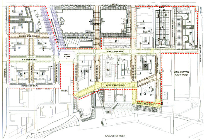
If you look at this map of the future layout of the Yards, you can see the 1st-and-M site at upper left, with plans for three buildings and a new east-west street (which this map says will be called Quander Street) about halfway down the block, along with the new "1 1/2 Street SE" running north-south from Quander to N Place.
|
Comments (5)
More posts:
Rearview Mirror, The Yards, Parcel A/Yards
|
 My dad has handed in the final installment of his memories of life on Capitol Hill, this time covering the very tumultous late 1960s. While there are plenty of good memories (and home movies!)--swimming at the Skyline Inn, birdbath martinis at the Market Inn, the Gangplank, and my brother's days attending the nascent Capitol Hill Day School--Dad's essay focuses in large part on the 1968 riots after the assassination of Martin Luther King, Jr., and the impact it had for people living on the Hill.
We left the Hill--and Washington--in late 1969 when Dad took a job in Chicago, but we returned to the area in 1977, living in Chevy Chase but always keeping our ties the Hill strong, both professionally through Dad and my brother's jobs and then personally when I moved to the Hill in 1994.
When my now-husband and I bought our house in June 1995, right as DC was hitting rock bottom and just before the financial control board was instituted, most of our friends were more than a little concerned about our decision, especially given that this was how many people thought of Washington outside of far Northwest and the National Mall. But Dad and Mom certainly approved of my decision to put down stakes back in the neighborhood where their life together--and my life!--had started.
So, this brings this nice wintertime diversion to an end, and I hope people have found it interesting. And maybe it's spurred a few of you to get your parents' memories of your childhood neighborhood (wherever it may be), and maybe some longtime Hill residents have shaken loose a few of their own recollections while reading this. (I know I've gotten a number of "Yes! The Oakland Inn!" responses.)
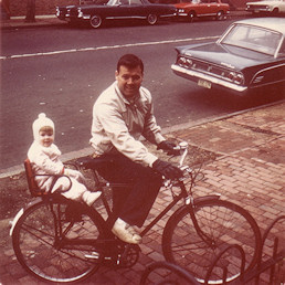
Thanks for doing this, Dad, and now go get back on your bike: spring is coming.
|
Comments (0)
More posts:
Rearview Mirror
|
 Dad's been under the weather for the past few weeks (for the first time in about 30 years), but is thankfully feeling better and has now passed along another batch of memories of life on Capitol Hill.
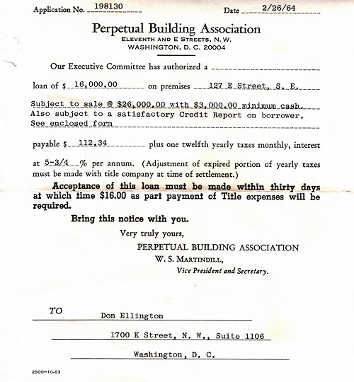
 This time he's written on a subject matter that's almost on-topic for JDLand: residential real estate, with a lot of detail from when he and my mother purchased 127 E St., SE, in early 1964. (He even dug into his files and found the paperwork from the sale, which amounted to all of about four pages, which I've included.) And he recounts a trip through the city bureaucracy to build the garage that's still out back of 127 E today--it wasn't smooth sailing, but I bet it was still a lot easier than it would be now!
He also talks a bit about the old Weisfeld's Market, from when it was at 131 E St. More recent Hill citizens may remember Weisfeld's in its later location, at the corner of 4th and E, where the Capitol Supreme Market now operates. There's also talk of The Rotunda, and a first mention of Mr. Henry's, which he says helped "extend the boundaries of where Hill people felt comfortable going." You know, alllllll the way out to 6th and Pennsylvania, SE.
I also took the opportunity to add some multimedia offerings to give everyone some looks at the 100 block of E during the mid-1960s.
Thanks again to Dad for taking the time to write this all down. Maybe when I get him and Mom down to the neighborhood for a baseball game this year, we'll set up for a bit beforehand somewhere (Das Bullpen?) and interested parties can swing by to chat.
|
Comments (0)
More posts:
Rearview Mirror
|
It's becoming a Friday tradition (think of it like the magazine that comes in your weekend paper) -- my father has sent along another batch of memories of living on Capitol Hill, during the Kennedy years of 1961 to 1963. He even briefly mentions Near Southeast (mainly to say they hardly ever ventured south of Virginia Avenue), as well as lots of other landmarks of the city at the time, like the Marine Barracks, the beer garden at Griffith Stadium, biking to DC Stadium to see the Redskins, and the various places in Maryland and Virginia that he bowled. (Bowling was very big at the time, and a good way to meet chicks, as he explains. One bowling beauty in particular caught his eye.)
There was also touch football, which of course was practically a requirement during the Kennedy era (and I've added a home movie clip to make this a true multimedia offering). He also talks about the old Oakland Inn just over the line in Maryland, famous for its fried chicken and to which I even remember being taken once when I was probably in junior high.
And, sadly, as with any memories of the era, it includes the events of Nov. 22, 1963.
I just can't help but picture the cast of Mad Men as I read all of these! I'm passing the comments that people have sent back to Dad (and I think he's peeking in as well), so thanks for the continued indulgence--I think it's a nice little side project during the less newsy winter months. And it's especially nice for me since I don't have to do the writing. Or pay him. :-)
|
Comments (0)
More posts:
Rearview Mirror
|
Like a batty old relative pulling out the photo albums for the umpteenth time, I'll take a moment to mark today as the eight-year anniversary of my tracking the changes that were starting to take place south of the freeway. The 63 photos I took while Mr. JDLand drove me around aren't a complete archive of every building in the neighborhood at that time, because frankly all I was doing that day was getting a few shots for myself and not planning the launch of an obsessive compulsive project that would suck up almost all of my free time and energy for years to come. But I came home and put them on my web site so my father could see them, made up a page with some links so I could easily go back to sites to check for updates, and off we went.
And now maybe it's just as noteworthy to mark Jan. 19, 2003 as the day I took the shot of the Little Red Building standing alone, since that's become the somewhat iconic shot of where the neighborhood was compared to what it was about to become.
Anyway, it's been quite a ride for eight years, with a lot of words and a lot pictures (about 50,000 of them), and I hope that people are continuing to find the site useful and interesting. Thanks for reading, commenting, and sending me news and tips! Hopefully 2011 will be a bounty of news and happenings.
[PS: Is it a sign of a marriage that's getting long in the tooth that I swore the anniversary was actually tomorrow until I saw the "Today in (Recent) Near Southeast History" box on the right side of the home page? So--oops--I guess my State of the Hood is going to be posted on my eight-year-and-one-day anniversary. And I'll also note that today is not the actual JDLand.com anniversary, because I've had my own web site since late 1994 and bought the JDLand domain name in 1996. Old-timers may remember that I didn't even give my Near Southeast stuff the main JDLand.com URL until 2007.]
|
Comments (0)
More posts:
Rearview Mirror, JDLand stuff
|
It's almost the weekend, there's not much news, so it's as good a time as any for another installment from my dad of his memories of living on Capitol Hill in the 1960s. JFK's run for the presidency and inauguration, the Monocle, Mark Russell at the Carroll Arms Hotel, Capitol Hill "security," run-ins with the construction workers building the Rayburn House Office Building, becoming a Hill biker, forays into Southwest, and cases of beer stashed in snowbanks are on the menu for this latest entry looking at life the early 1960s. And there's more to come, because Dad is now really getting into his "writing assignment." I'm really enjoying reading these, and I hope one or two folks out there are as well.
|
Comments (0)
More posts:
Rearview Mirror
|
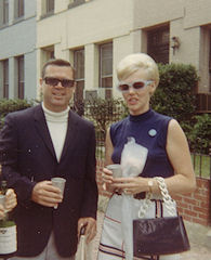 As I've always tried to emphasize when I'm asked about the origins of JDLand, I'm a historian at heart--I love knowing about how areas I'm familiar with looked and functioned in the past, especially the more recent past, when you can still see of few of the strings tying that era to the present day.
 This is very much the case for me for Capitol Hill, land of my birth, and I'm lucky enough to have two very good resources to turn to whenever I want to hear some good stories about what my neighborhood was like back in the Mad Men era: my mother and father. Jim and Shirley each moved to DC in 1959, got married a few years later, and lived on the House side of the Hill until 1969, and it's no secret that they look back upon those years with great fondness.
Since I'm all about documenting stuff before it disappears, I recently asked Mom and Dad if they would write up for me their memories of what it was like to live on the Hill during the 1960s. Luckily it's the offseason for both bicycling (Dad) and golf (Mom), so they agreed to squeeze some writing into their schedules, and while the resulting reminiscences are mostly for the family's benefit and enjoyment, I thought that some readers might find them of interest as well, and since the web site has infinite space, and since it's wintertime, when news is slow...
First up is a short post by my dad, talking a little about when he moved to the Hill in 1959, living in the 400 block of New Jersey Ave., SE., with his brother, for $100 a month. (I also tossed in at the bottom some of the home movies showing Hill scenes, most of which I've linked to before, but I figure some multimedia can't hurt.)
If you have questions for Dad about his post or just want to pick his brain for other memories of his, post here in the comments, and I'll make sure he reads them and replies. He's already working on his next offering, so maybe some queries from the peanut gallery will rattle loose some additional nuggets to pass along.
(And hopefully before too long I'll get a submission from Mom, so that she can tell the stories of shopping at Weisfeld's when it was still in the 100 block of E and how Mrs. Weisfeld would just write what you owed on the back of a brown paper bag, and then give you a bill at the end of the month. But I don't want to steal her thunder.)
UPDATE: Like his daughter, Dad has discovered that writing about something interesting can take on a life of its own--he's submitted his second post about the Hill in the early '60s, with tidbits on the Kennedy inauguration (and its accompanying snowstorm) and the construction of the Rayburn House Office Building, along with a few famous names, memories of biking around the Hill, and even a little bit about Southwest. I'll post it in a couple of days.
|
Comments (0)
More posts:
Rearview Mirror
|