
|
| |||||||||||||||||||

|
Please note that JDLand is no longer being updated.
peek >>
Near Southeast DC Past News Items: Rearview Mirror
- Full Neighborhood Development MapThere's a lot more than just the projects listed here. See the complete map of completed, underway, and proposed projects all across the neighborhood.
- What's New This YearA quick look at what's arrived or been announced since the end of the 2018 baseball season.
- Food Options, Now and Coming SoonThere's now plenty of food options in the neighborhood. Click to see what's here, and what's coming.
![-]()
- Anacostia RiverwalkA bridge between Teague and Yards Parks is part of the planned 20-mile Anacostia Riverwalk multi-use trail along the east and west banks of the Anacostia River.
![-]()
- Virginia Ave. Tunnel ExpansionConstruction underway in 2015 to expand the 106-year-old tunnel to allow for a second track and double-height cars. Expected completion 2018.
![-]()
- Rail and Bus Times
Get real time data for the Navy Yard subway, Circulator, Bikeshare, and bus lines, plus additional transit information. - Rail and Bus Times
Get real time data for the Navy Yard subway, Circulator, Bikeshare, and bus lines, plus additional transit information. - Canal ParkThree-block park on the site of the old Washington Canal. Construction begun in spring 2011, opened Nov. 16, 2012.
![-]()
- Nationals Park21-acre site, 41,000-seat ballpark, construction begun May 2006, Opening Day March 30, 2008.
![-]()
- Washington Navy YardHeadquarters of the Naval District Washington, established in 1799.
![-]()
- Yards Park5.5-acre park on the banks of the Anacostia. First phase completed September 2010.
![-]()
- Van Ness Elementary SchoolDC Public School, closed in 2006, but reopening in stages beginning in 2015.
![-]()
- Agora/Whole Foods336-unit apartment building at 800 New Jersey Ave., SE. Construction begun June 2014, move-ins underway early 2018. Whole Foods expected to open in late 2018.
![-]()
- New Douglass BridgeConstruction underway in early 2018 on the replacement for the current South Capitol Street Bridge. Completion expected in 2021.
![-]()
- 1221 Van290-unit residential building with 26,000 sf retail. Underway late 2015, completed early 2018.

- NAB HQ/AvidianNew headquarters for National Association of Broadcasters, along with a 163-unit condo building. Construction underway early 2017.

- Yards/Parcel O Residential ProjectsThe Bower, a 138-unit condo building by PN Hoffman, and The Guild, a 190-unit rental building by Forest City on the southeast corner of 4th and Tingey. Underway fall 2016, delivery 2018.

- New DC Water HQA wrap-around six-story addition to the existing O Street Pumping Station. Construction underway in 2016, with completion in 2018.

- The Harlow/Square 769N AptsMixed-income rental building with 176 units, including 36 public housing units. Underway early 2017, delivery 2019.

- West Half Residential420-unit project with 65,000 sf retail. Construction underway spring 2017.
![-]()
- Novel South Capitol/2 I St.530ish-unit apartment building in two phases, on old McDonald's site. Construction underway early 2017, completed summer 2019.
![Novel South Capitol]()
- 1250 Half/Envy310 rental units at 1250, 123 condos at Envy, 60,000 square feet of retail. Underway spring 2017.
![-]()
- Parc Riverside Phase II314ish-unit residential building at 1010 Half St., SE, by Toll Bros. Construction underway summer 2017.
![-]()
- 99 M StreetA 224,000-square-foot office building by Skanska for the corner of 1st and M. Underway fall 2015, substantially complete summer 2018. Circa and an unnamed sibling restaurant announced tenants.
![-]()
- The Garrett375-unit rental building at 2nd and I with 13,000 sq ft retail. Construction underway late fall 2017.
![-]()
- Yards/The Estate Apts. and Thompson Hotel270-unit rental building and 227-room Thompson Hotel, with 20,000 sq ft retail total. Construction underway fall 2017.
![-]()
- Meridian on First275-unit residential building, by Paradigm. Construction underway early 2018.
![-]()
- The Maren/71 Potomac264-unit residential building with 12,500 sq ft retail, underway spring 2018. Phase 2 of RiverFront on the Anacostia development.
![-]()
- DC Crossing/Square 696Block bought in 2016 by Tishman Speyer, with plans for 800 apartment units and 44,000 square feet of retail in two phases. Digging underway April 2018.
![DC Crossing]()
- One Hill South Phase 2300ish-unit unnamed sibling building at South Capitol and I. Work underway summer 2018.
![One Hill South Phase 2]()
- New DDOT HQ/250 MNew headquarters for the District Department of Transportation. Underway early 2019.
![New DDOT HQ]()
- 37 L Street Condos11-story, 74-unit condo building west of Half St. Underway early 2019.
![37 L Condos]()
- CSX East Residential/Hotel225ish-unit AC Marriott and two residential buildings planned. Digging underway late summer 2019.
![CSX East Residential/Hotel]()
- 1000 South Capitol Residential224-unit apartment building by Lerner. Underway fall 2019.
![1000 South Capitol Residential]()
- Capper Seniors 2.0Reconstruction of the 160-unit building for low-income seniors that was destroyed by fire in 2018.
![1000 South Capitol Residential]()
- Chemonics HQNew 285,000-sq-ft office building with 14,000 sq ft of retail. Expected delivery 2021.
![1000 South Capitol Residential]()


A few things to pass along as we kiss summer goodbye (yes, I know it technically doesn't end for another few weeks, blah blah blah):
* The Capitol Riverfront BID is applying for a DC Public Art Building Communities grant to get funding to "improve the look, feel and experience of traveling into and out of the Capitol Riverfront along New Jersey Ave., SE, while also creating unique gateway art that represents the identity, sense of place and community in the Capitol Riverfront neighborhood." They will be presenting their concepts at the Sept. 13 ANC 6D meeting, with applications being due on Oct. 13. If the project is selected to receive a grant, there would be public meetings sometime next year to "refine" the concepts, with hopes to complete the project by fall 2011. Though I can't imagine why anyone would want to beautify THIS!
* I'm not seeing this on the posted agenda yet, but a reader reports to me that CSX will be making presentations to ANC 6B's Planning and Zoning Committee tonight (Sept. 7) and the full ANC on Sept. 21 about a permit the freight company is apparently requesting to conduct an archaeological survey of Virginia Avenue Park prior to their planned expansion of the tunnel that runs under the park.
* Tonight you might see some folks with clipboards hanging around the Navy Yard Metro station entrances; they will be part of the Public Transportation Takes Us There petition drive by the American Public Transportation Association, trying to convince Congress to pass a long-term surface transportation funding bill. For the point of view of someone who has signed the petition, read this recent Richard Layman post. (I am wondering, and have no answer, whether this is the bill that CSX has been looking toward [along with other public money options] for funding the rest of the National Gateway project, which includes the expansion of the Virginia Avenue Tunnel.)
* You may have seen commenter MJM referencing recently his newfound obsession with the history of Near Southeast, and now he's put up a blog where you can share in the fruits of his research.
|
Comments (0)
More posts:
ANC News, Capitol Riverfront BID, CSX/Virginia Ave. Tunnel, meetings, New Jersey Ave., Rearview Mirror, Nationals Park, Virginia Ave Park
|
Two DDOT-related items of note to pass along: * Adding to their growing Flickr cache of historic photos, DDOT has posted 23 photos from the construction of the Southeast/Southwest Freeway. They're a bit grainy (they look like they may have gotten water-splattered at some point), but most of them are from the area along Virginia Avenue near 6th Street, SE, so you'll see the old Capper Apartment buildings at 5th and Virginia, along with the Ellen Wilson projects that were north of Virginia. When I get some spare moments, I will of course be grabbing some of these shots to add to my own Historic Photos page (thank you, Creative Commons license!). This is wonderful of DDOT to be posting photos from their archive, and I hope they keep them coming. And other DC agencies with their own photo archives should take note.
* There's been a couple changes to the route of the Union Station-Navy Yard Circulator: "Service on this line has been streamlined near Columbus Circle in front of Union Station, providing a faster trip and allowing passengers to transfer between the Georgetown route and Navy Yard route on Massachusetts Avenue.Stops have also been added on Seward Square (Pennsylvania Avenue at 5th Street SE) on Capitol Hill. Because of construction to begin this fall on Columbus Circle, the stop at Delaware Avenue had to be discontinued for passenger safety."
* Adding to their growing Flickr cache of historic photos, DDOT has posted 23 photos from the construction of the Southeast/Southwest Freeway. They're a bit grainy (they look like they may have gotten water-splattered at some point), but most of them are from the area along Virginia Avenue near 6th Street, SE, so you'll see the old Capper Apartment buildings at 5th and Virginia, along with the Ellen Wilson projects that were north of Virginia. When I get some spare moments, I will of course be grabbing some of these shots to add to my own Historic Photos page (thank you, Creative Commons license!). This is wonderful of DDOT to be posting photos from their archive, and I hope they keep them coming. And other DC agencies with their own photo archives should take note.|
Comments (0)
More posts:
circulator, Rearview Mirror
|
(A sadly well-timed edition of my series of posts looking back on the "old" Near Southeast)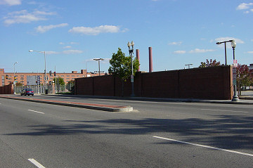 The family then went to a Metrobus stop on the south side of the 200 block of M Street, SE, standing on what was at that time a narrow sidewalk with the long red brick wall left over from the Navy Yard days behind it. Also at the bus stop were 18-year-old Charron McKethean and her six-month old daughter Charquita, who lived at 210 L St., SE, in the Cappers; they were going shopping with Charron's best friend Linda Taylor and Taylor's boyfriend Willie Callihan for an outfit for Charquita's christening the next day.
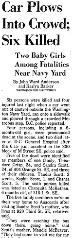 Seven of group were killed: Sandra Scott and her entire family died, as well as six-month-old Charquita McKethean and Linda Taylor, who was 18 and lived in the 200 block of M Street, SW. It was believed to be the deadliest car accident in the city's history to that time, and appears to still hold that title today.
On August 25, 1984, 24-year-old Sandra Scott of Anacostia went on a birthday visit to her mother, Maudie McBrayer, at her Capper apartment at 920 Third Street, SE. Sandra brought her husband, Theodore "Teddy" Crisp, and their three children, five-year-old Chanta, one-year-old Sophia, and six-week-old baby Tandra.
The family then went to a Metrobus stop on the south side of the 200 block of M Street, SE, standing on what was at that time a narrow sidewalk with the long red brick wall left over from the Navy Yard days behind it. Also at the bus stop were 18-year-old Charron McKethean and her six-month old daughter Charquita, who lived at 210 L St., SE, in the Cappers; they were going shopping with Charron's best friend Linda Taylor and Taylor's boyfriend Willie Callihan for an outfit for Charquita's christening the next day.As they waited at around 6:15 pm, a Plymouth Valiant going eastbound at an estimated 70 to 80 mph in the westbound lanes struck the median, went airborne, landed in the eastbound lanes, partially hopped the curb, and struck all nine people waiting for the bus. The car then flipped, crashed, and burst into flames near Third Street.
The Washington Post described rescue personnel calling the resulting scene "one of the most gruesome they had witnessed," with some of the victims having been crushed by the car against the wall and a lamppost on the sidewalk. "I've been 21 years on this job, and I've never seen anything like it," said Fire Capt. James Thorn, saying that the driver had "just ground [the victims] right into" the lamppost and the brick wall.
Seven of group were killed: Sandra Scott and her entire family died, as well as six-month-old Charquita McKethean and Linda Taylor, who was 18 and lived in the 200 block of M Street, SW. It was believed to be the deadliest car accident in the city's history to that time, and appears to still hold that title today.The driver of car was 41-year-old Robert Lee Williams, whose blood alcohol level at the time of the crash was .10 and who admitted to having used heroin about 25 minutes before the crash. He had been paroled six weeks earlier after serving less than four years of a 20-year sentence for a 1980 bank robbery conviction in Alexandria, and was also on parole in the District for a 1977 armed robbery conviction. There were also convictions for housebreaking, robbery, and grand larceny on his record.
In 1985, Williams pleaded guilty to two counts of manslaughter while armed (with a car) and five counts of manslaughter, along with a count of driving while intoxicated. He was sentenced to 35 to 105 years in prison. At his sentencing, he told the courtroom that he was sorry and would give his "own life to save those kids." Charron McKethean, one of the crash's two survivors and mother of one of the youngest victims, was in the courtroom with her 2 1/2-month-old baby, and told the Post, "I couldn't look at the man that killed my daughter. The sentence was reasonable, but it is not going to bring back any of our lives."
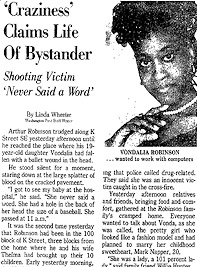
 They say you never really know what's going on inside the walls of someone's home, and that certainly would have been the case if you had wandered by the northwest corner of Half and N in the early 1980s. The red brick rowhouse at 36 N Street, SE (seen at left in May 2003) would have looked unassuming enough to you, until you opened up your copy of the Washington Post on March 2, 1981, and read this:
"It was his first night at The Playground Swing Club in Southeast Washington, and the 37-year-old Army veteran was ready. He stripped and headed up the red-carpeted stairs to the lounge where a few men and women, most dressed only in robes, were sitting on cushioned floors and platforms. [...] Soon, he and a young woman he had never before met strolled into The Playroom, where bodies were lying in all directions on mattresses and a raised platform. He and the woman joined in. 'Everybody freeze!" a voice suddenly shouted. 'This is a raid!' "
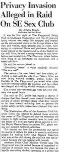 DC police had spent six weeks investigating The Playground, work which included having two undercover police couples "stripped to their underwear [who] spent three hours listening to the friendly discussions and watching the lovemaking." But when the bust happened in February of 1981, there were no charges of anyone paying for sex: the owner eventually was sentenced to 30 days in jail and fined $500 for operating a public hall without a license and failing to have a proper certificate of occupancy for the club. An additional charge of selling alcohol without a license was dropped.
A few of the "participants" at the house that night were charged under the city's sodomy laws, which brought swift condemnation from the ACLU: "Sexual conduct between consenting adults is none of the government's business." The raid also made for titillating reading in the Post, as the paper dryly explained the "swinging" culture: "What was happening at The Playground was a plain and simple orgy--an activity that seems to have become as common among a certain underground of adults as was dancing cheek-to-cheek in the 1930s."
The Playground was closed soon after, and a 1982 attempt to turn 36 N into an "erotica museum" was shot down by the city and neighbors. The rowhouse itself lasted until 2005, getting demolished two years before its neighbors met the wrecking ball as well. The site, now owned by Akridge as part of its Half Street footprint, is directly across from Nationals Park (which I guess you could also call a swinging establishment!), where the Bullpen now provides a different brand of entertainment during baseball season.
As for the Playground's owner? It was Dennis Sobin, longtime city activist and current mayoral candidate. A profile of Sobin earlier this year by the Georgetown Voice gives a quick summary of his years in Washington, including his ownership of multiple strip clubs, adult bookstores, and brothels in the late 70s, a third-place finish in the 1982 mayor's race, and a 10-year prison term in Florida on child pornography charges. He currently runs the Prisons Foundation, devoted to prison artists and their work.
(And no, I had no idea that this little item would end up tied to current city politics when I started!)
|
Comments (0)
More posts:
West Half St., Fairgrounds/Bullpen, Rearview Mirror
|
Readers may be familiar with the map a little ways down the right side of the JDLand home page, showing recent crimes in the neighborhood (along with a larger one showing more crime statistics for the area since 2005). However, there's another map and dataset I've wanted to build for a long time, that I'm finally launching today. It's not anything to really celebrate, however: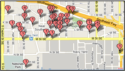
 It turns me into an old codger to say it, but it's really true: those of you who didn't live in the DC area in the late 1980s and 1990s really have no concept of what Washington and its residents went through in those years. Even though large swaths of the city were considered "safe," with the bulk of the epidemic crime happening in certain neighborhoods, everyone was affected by the unrelenting drumbeat of murders and violence.
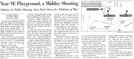
 And yet the violence of the era probably fueled my interest in watching the city's redevelopment, to see neighborhoods that I had given up for lost in 1990 (such as Massachusetts Avenue east of Mt. Vernon Square) turn into luxury condo havens by the early 2000s. And it was why I began to watch--with no small sense of wonderment and even a little skepticism--as I started to hear in the late 1990s about the plans to "revitalize" the area south of the Southeast Freeway, an area that was a near-total No-Go for me from the time I moved to the south side of Capitol Hill in 1994 until my first furtive photographic forays by car in 2000 and 2003. (It's somewhat amazing now to realize that I did not actually put my feet on the ground at Third and K, SE, until the summer of 2005.)
What you're looking at is a map of 64 violent deaths that occurred in Near Southeast between 1987 and 2004, when crack and other drugs and the accompanying violence nearly destroyed Washington, DC. And, if you go to the page itself, you will see the breakout of each death, with a name of the victim (when available), the date and location, and a brief thumbnail of what happened. The map and the data are interactive, so you can view just by year, or location, or type of death. It's not uplifting reading, but I really do recommend taking the time to go through it.
I can't pretend that this is a complete list; there are no online databases that easily offer up this data. I spent hours (and hours and hours) doing "grid searches" of the Washington Post and Washington Times electronic databases, having to search by street names and locations ("300 block of K street, SE; 300 block of L Street, SE; 3rd and K streets, SE; 1000 block of 3rd Street, SE;" etc. etc.). There's no guarantee that the newspapers mentioned every homicide, especially in the years when there were more than 400 murders across the city.
And, of course, this doesn't begin to capture the number of other crimes in the neighborhood during those years that didn't result in homicides--the robberies, the assaults, the non-fatal shootings and stabbings, etc.
It should be remembered that Near Southeast wasn't anywhere close to being the most dangerous area in the city; the 64 murders I've documented aren't even one percent of the 6,023 murders reported in this 18-year period (source: MPD, via the Internet Archive). So, as you look at this Near Southeast list, multiply it by 100 to imagine all the people who were killed in the city in those years.
It turns me into an old codger to say it, but it's really true: those of you who didn't live in the DC area in the late 1980s and 1990s really have no concept of what Washington and its residents went through in those years. Even though large swaths of the city were considered "safe," with the bulk of the epidemic crime happening in certain neighborhoods, everyone was affected by the unrelenting drumbeat of murders and violence. Nights with seven murders in DC were unusual but not extraordinary; reading the paper each day with little more than tiny blurbs on most homicides (because they weren't really "news") made for a bleak landscape, even if you spent most of your time in sections of the city where day-to-day life seemed unaffected. DC's title of "Murder Capital of the World" was known far and wide, to the point that if you were traveling and told someone where you from, you'd often receive a sad shake of the head and hear, "It's such a shame what's happened to that lovely city."
It was a terrible time; and I say this as someone who was never affected by the violence personally in any way, other than knowing to avoid certain areas and be very careful during nights on the town. Looking back on it all now, through the lens of how far the city has come, makes the level of violence seem all the more incomprehensible and maddening. There's no question that I have become a little haunted over the past few weeks as I compiled this list, as my old generalized feelings of "quite a few people died on these streets over the years" have now been replaced with names, locations, a few photos, and gruesome details of executions and people in the wrong place at the wrong time.
And yet the violence of the era probably fueled my interest in watching the city's redevelopment, to see neighborhoods that I had given up for lost in 1990 (such as Massachusetts Avenue east of Mt. Vernon Square) turn into luxury condo havens by the early 2000s. And it was why I began to watch--with no small sense of wonderment and even a little skepticism--as I started to hear in the late 1990s about the plans to "revitalize" the area south of the Southeast Freeway, an area that was a near-total No-Go for me from the time I moved to the south side of Capitol Hill in 1994 until my first furtive photographic forays by car in 2000 and 2003. (It's somewhat amazing now to realize that I did not actually put my feet on the ground at Third and K, SE, until the summer of 2005.)I'll be writing in more detail in future entries about the violence in the Cappers, and at the Chapter III nightclub, but I wanted to post this overview first, to illustrate Near Southeast's descent to rock bottom for the people who might not be familiar with the recent history of the neighborhood, and also to remind everyone else of just what we as a city went through, as those memories become somewhat hazy in an era when some of the biggest battles are over funding for streetcars and dog parks. The city is certainly not without violence now, but the scale just doesn't compare.
And perhaps it'll also help clear up why I might not react with quite so much alarm when new residents write me concerned about a wave of auto thefts or other property crimes. I admit that it's somewhat unfair, but I think newcomers can talk to almost anyone who lived in Washington during the era of the Crack Wars and get the same reaction: You just have no idea.
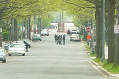
UPDATE: Just to close the circle a bit, I should note that the reason I ended the dataset in 2004 is because, to the best of my knowledge, there have been no murders in Near Southeast since 21-year-old Terence Gathers died at Third and K on March 25 of that year.
Via the BID's latest newsletter: "Share your stories of the historic Southeast DC neighborhood as we embark on the creation of a new Neighborhood Heritage Trail in the Capitol Riverfront. Cultural Tourism DC, in partnership with the Capitol Riverfront BID, is holding two community meetings for the public to share stories, bring photos and help shape the community's heritage trail. The first meeting will be on Wednesday, June 23rd at 7 PM at Arthur Capper Senior I, 900 Fifth Street, SE." See the flyer for more information.
(This is also a good time to mention that there won't be a Sunday Rearview Mirror this weekend--I have a good one on tap for next week, though.)
|
Comments (0)
More posts:
Capitol Riverfront BID, Rearview Mirror
|
(Sunday Rearview Mirror is my new probably-not-weekly series where I'll look back at random pieces of Near Southeast history, giving readers who perhaps didn't know the area existed before the arrival of the Nationals some context and understanding of what this once "forgotten" neighborhood used to be like.)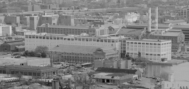
 But I found a lot of other "lost" buildings as well, ones that I didn't remember and that probably weren't much to look at at the time, but that help to give a clearer view of what the neighborhood truly looked like just before its first "growth spurt" in 1999-2001 with the arrival of NAVSEA at the Navy Yard. The big finds were the seven or so old rowhouses just north of the (sparkling new) Navy Yard Metro station entrance on New Jersey Avenue, along with another 10 or so along L and Second Streets on what is now the Capitol Hill Tower/Courtyard block. (The Little Red Building did not stand alone since the dawn of time.) The car repair garage and other gritty low-rise buildings that stood where the 1100 New Jersey Avenue office building now is. And so on.
Though I've documented more than 150 buildings that have been demolished in Near Southeast since I first started photographing the area (initially in fall 2000 and then for real beginning in January 2003) I had taken enough brief drives through the neighborhood in the late 1990s to know that there were a few other long-standing sites that I didn't manage to capture before they were gone. This has bugged me for years, not only because I hate having missed them for my own archive but because I felt like they were an important part of what made up the old Near Southeast.
So it was with a fair amount of wonderment that I spent time over the past week pouring through images from the National Park Service's HABS, HAER and HALS archive of photos, available online thanks to the Library of Congress. The collection contains photos taken above New Jersey, Virginia, and Potomac avenues from helicopter height in 1992, and while I had seen some of these before, I had never downloaded the massive .TIFF images that allowed zooming in to such a degree that buildings and streetscapes became clearly visible.
Buildings I had longed to see documented in public domain photographs*, most of which were demolished in 1999 and 2000, now reappeared, albeit from overhead, in black-and-white and what and sometimes only in grainy depictions. But there they were: Tracks, the nightclub at First and M. The four Capper apartment buildings on Seventh Street and Virginia Avenue. The massive Building 159 at the Southeast Federal Center (seen above). The Washington Star warehouse just south of the freeway that I had driven past hundreds of times but never photographed.
But I found a lot of other "lost" buildings as well, ones that I didn't remember and that probably weren't much to look at at the time, but that help to give a clearer view of what the neighborhood truly looked like just before its first "growth spurt" in 1999-2001 with the arrival of NAVSEA at the Navy Yard. The big finds were the seven or so old rowhouses just north of the (sparkling new) Navy Yard Metro station entrance on New Jersey Avenue, along with another 10 or so along L and Second Streets on what is now the Capitol Hill Tower/Courtyard block. (The Little Red Building did not stand alone since the dawn of time.) The car repair garage and other gritty low-rise buildings that stood where the 1100 New Jersey Avenue office building now is. And so on.I gathered the images on a new page, with lots of narration of what they show, along with in some cases early photos of mine that captured a few of the buildings before they disappeared. I'm really thrilled that these pictures finally provide the bridge I've wanted for so long between what Near Southeast looked like for many years and what I captured when I first started nosing around.
In future Rearview Mirror posts I'll be talking more about many of these sites, so I didn't go into great detail on the histories of the buildings themselves, but I'm really happy that now there will be images to accompany the stories. I doubt most people will be as excited by these shots as I have been, but I still really recommend taking a few minutes to go through them.
* The "public domain" distinction is important, because I'm sure that photos of many of these buildings exist in other archives, but since they can't be shared online without my ponying up a bunch of $$, they're not of much use to me here.
|
Comments (0)
More posts:
Rearview Mirror
|
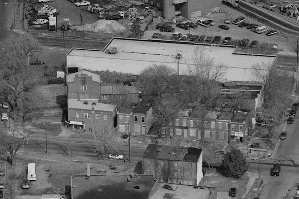
(For someone who graduated from college with a degree in history, I have done a lousy job over the years of documenting the history of Near Southeast with anything approaching the zeal of my coverage of its present and future. I can offer no good excuses, but I'm going to begin to rectify this with a new series, "Sunday Rearview Mirror." I don't pretend to have the level of knowledge or experience of the pre-ballpark era as those who passed through Near Southeast during those years, but hopefully by taking the time every so often to highlight and describe events from the past I can help make sure that the new residents and workers who only recently heard of Near Southeast have some awareness of the people and events that came before them.)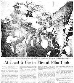 On Oct. 24, 1977, an explosion on the ground floor triggered by cleaning chemicals started a fire, with flames quickly consuming carpeting and wall hangings, blocking the exit for the patrons who had been in the 50-seat second floor theater. The fire never reached the second floor, but the smoke quickly became overpowering. However, a door that led to the roof was padlocked, and the windows had been replaced with cinderblocks. According to the Washington Post's account, "most of the victims were found in the orange-and-black theater seats [...] and may have been overcome by the smoke before they realized what was happening."
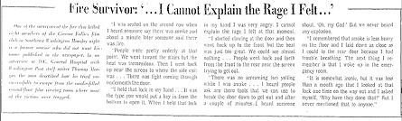
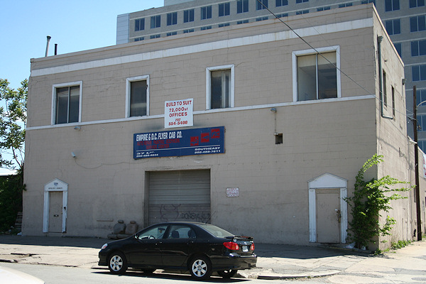 Within a year or the fire, Oates opened "The Follies" at its new location at 24 O St., SE, where it operated until it was demolished with many other gay nightclubs in May 2006 to make way for Nationals Park. Somewhat amazingly, the building where the Cinema Follies fire took place, which was not all that heavily damaged, still stands today, on L Street directly across from the under-construction 1015 Half office building. It's currently home to a cab company.
It was in the 1970s that the western edge of Near Southeast became home to a new entertainment district for the city's gay residents, with its remoteness and lack of nearby residences allowing some measure of freedom for a culture that was only just beginning to step out of the closet. The area between South Capitol and First streets--with clubs like the Lost and Found, Club Baths II, Grand Central, Waaay off Broadway and Washington Square--became home not only to nightclubs with dancing and music but also but bathhouses, x-rated movie cinemas, and strip clubs. One of the new clubs was the Cinema Follies, which opened in 1975 at 37 L St., SE, showing x-rated gay films.
On Oct. 24, 1977, an explosion on the ground floor triggered by cleaning chemicals started a fire, with flames quickly consuming carpeting and wall hangings, blocking the exit for the patrons who had been in the 50-seat second floor theater. The fire never reached the second floor, but the smoke quickly became overpowering. However, a door that led to the roof was padlocked, and the windows had been replaced with cinderblocks. According to the Washington Post's account, "most of the victims were found in the orange-and-black theater seats [...] and may have been overcome by the smoke before they realized what was happening."Nine people died as a result of the fire, making it the deadliest fire in Washington DC up to that time, a mark that stood until a fire at an unlicensed group home on Lamont Street, NW, killed 10 in April 1979. Identification of those who died at the Follies was hampered by the fact that, as the Post reported, "Many homosexuals do not carry identification when they visit homosexual gathering places," being "wary about the possibility of jeopardizing jobs or social position by having nonhomosexuals learn of their sexual orientation" in case their presence at club might be made public "through a police raid or other event."
(An interesting sidelight to the issue of identification was a column by Post ombudsman Charles Seib soon after the fire, questioning the Post's decision to not use the full names of some of those who died and no names at all of the injured. The column quoted then-Managing Editor Howard Simon as saying that the paper's main motivation was "compassion for the wives and children" [since some of the victims were married] but Seib went on to ask whether this approach had the effect of "underscoring the stigma of homosexuality, of shoving it back in the closet at a time when efforts are being made to bring it out and address it as a social fact?" This is an issue that papers still clearly struggle with, even today.)
William Oates, the manager of the club, was eventually fined $650 in 1979 for violating four building codes, though city officials stated that Oates "did everything possible" to try to comply with the laws, but poor city record keeping and poorly written codes made it difficult. (The city did work to strengthen its codes in the wake of the fire.) However, nearly eight years after the fire, in September of 1985, families of four of the victims were awarded more than $1.5 million in a civil suit against the club's owners.
 Within a year or the fire, Oates opened "The Follies" at its new location at 24 O St., SE, where it operated until it was demolished with many other gay nightclubs in May 2006 to make way for Nationals Park. Somewhat amazingly, the building where the Cinema Follies fire took place, which was not all that heavily damaged, still stands today, on L Street directly across from the under-construction 1015 Half office building. It's currently home to a cab company.
I plan to write more Rear-View Mirror entries in the future about the neighborhood's past as a nightclub district, but until then, this 2003 pamphlet by the Rainbow History Project gives a great overview of the clubs that used to be such an integral part of Washington's gay culture. Hard to believe that, when the pamphlet was written, the authors had no idea how little time the existing clubs had left.
|
Comments (0)
|
I'm just now coming across a Washington Post story entitled "Housing Area Pushing for Supermarket," which says that a group of residents "in a small triangle of Southeast Washington launched a 'supermarket project' yesterday to persuade a grocery chain to build a store in their neighborhood," with a planned petition drive looking to get 1,500 signatures.
But, of course, I'm yanking your chain, since this Post article is dated Dec. 16, 1965.
The group, the "Community Commitee Group," planned to visit the regional offices of Safeway, Giant, and Kroger to present the case that the residents of the area bounded by 8th, Virginia, M, and New Jersey had only two corner groceries, with the closest supermarket being at Seventh and G, SE, which was too far for the "aged who live in the Carrollsburg Dwellings project at Fourth and M." Also, because many of the residents in the area qualified for food stamps, they needed to be able to shop at a full supermarket, where the stamps would stretch farther.
The group "also hopes to interest a chain drug store and a combination dry cleaning-shoe repair shop to locate next to the proposed supermarket." Their suggested locations? "The west side of New Jersey Avenue between K and L Streets to replace some condemned buildings [ahem], the Washington Navy Yard parking lot on 2nd Street between M and I Streets [ahem], and the Lennox School annex at 4th and M Streets [ahem]."
In the meantime, while you're mourning the fact that no progress has been made in the brief 45 years since this article was published, you can think about another big development that Near Southeast missed out on: In the early 1990s the Federal Bureau of Prisons was looking for a location for a new 1,000-bed federal detention center, and one of the spots it considered was on the north side of I Street between South Capitol and New Jersey, the spot that's now home to the Axiom and Jefferson apartment buildings. And McDonald's. And Splash. (The other possible locations were in Northeast, but after battles with the National Capital Planning Commission and thanks to some pretty staunch opposition by city officials and residents, the Justice Department scrapped the plans in 1993.)
|
Comments (0)
|
Back before it was painted all manner of shades of blue, the building on the northwest corner of Eighth and M known as the "Blue Castle" was a car barn for the DC streetcar system. Madison Marquette, now the owners of the building, have just posted on Facebook a bunch of historic photos showing both the building in its pre-blue days as well as lots of shots of the old DC trolleys and streetcars. Definitely worth checking out.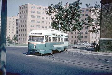 And this gives me an excuse to link to my own Historic Photos page, which includes some of the photos that Madison Marquette posted along with others of the neighborhood from about 1918 to 1992. (There's also my Historic Maps page, for plats showing the neighborhood for various years between 1903 and 1921, if you want more wayback goodness.)
And this gives me an excuse to link to my own Historic Photos page, which includes some of the photos that Madison Marquette posted along with others of the neighborhood from about 1918 to 1992. (There's also my Historic Maps page, for plats showing the neighborhood for various years between 1903 and 1921, if you want more wayback goodness.) There are a lot more cool historic Near Southeast images out there, but unfortunately some libraries and historical societies tend to be quite strict about reproducing photos from their archives (often requiring payment even for use of low-res images that already exist online), so rather than those photos getting seen by people who are truly interested, they languish in file cabinets or little-used online databases. It's a shame, because I could have a lot of fun with them, but the attendant bureaucracy has pretty well stifled my interest in pursuing them any farther or even linking to them. Plus I'm too honorable to just steal the thumbnails and post them anyway, which I could certainly do. (And you can be very sure that my photos will never end up with these levels of restrictions.)
At least the great archive of historic photos that DDOT had begun to populate a few years ago is still around (though not on their new site, you kind of have to go digging for it via Google). Hopefully they'll get around to adding more shots. I've got a scanner, DDOT, let me at them!
|
Comments (0)
More posts:
Blue Castle, 8th Street, Rearview Mirror
|