
|
| |||||||||||||||||||

|
Please note that JDLand is no longer being updated.
peek >>
Near Southeast DC Past News Items: photos
- Full Neighborhood Development MapThere's a lot more than just the projects listed here. See the complete map of completed, underway, and proposed projects all across the neighborhood.
- What's New This YearA quick look at what's arrived or been announced since the end of the 2018 baseball season.
- Food Options, Now and Coming SoonThere's now plenty of food options in the neighborhood. Click to see what's here, and what's coming.
![-]()
- Anacostia RiverwalkA bridge between Teague and Yards Parks is part of the planned 20-mile Anacostia Riverwalk multi-use trail along the east and west banks of the Anacostia River.
![-]()
- Virginia Ave. Tunnel ExpansionConstruction underway in 2015 to expand the 106-year-old tunnel to allow for a second track and double-height cars. Expected completion 2018.
![-]()
- Rail and Bus Times
Get real time data for the Navy Yard subway, Circulator, Bikeshare, and bus lines, plus additional transit information. - Rail and Bus Times
Get real time data for the Navy Yard subway, Circulator, Bikeshare, and bus lines, plus additional transit information. - Canal ParkThree-block park on the site of the old Washington Canal. Construction begun in spring 2011, opened Nov. 16, 2012.
![-]()
- Nationals Park21-acre site, 41,000-seat ballpark, construction begun May 2006, Opening Day March 30, 2008.
![-]()
- Washington Navy YardHeadquarters of the Naval District Washington, established in 1799.
![-]()
- Yards Park5.5-acre park on the banks of the Anacostia. First phase completed September 2010.
![-]()
- Van Ness Elementary SchoolDC Public School, closed in 2006, but reopening in stages beginning in 2015.
![-]()
- Agora/Whole Foods336-unit apartment building at 800 New Jersey Ave., SE. Construction begun June 2014, move-ins underway early 2018. Whole Foods expected to open in late 2018.
![-]()
- New Douglass BridgeConstruction underway in early 2018 on the replacement for the current South Capitol Street Bridge. Completion expected in 2021.
![-]()
- 1221 Van290-unit residential building with 26,000 sf retail. Underway late 2015, completed early 2018.

- NAB HQ/AvidianNew headquarters for National Association of Broadcasters, along with a 163-unit condo building. Construction underway early 2017.

- Yards/Parcel O Residential ProjectsThe Bower, a 138-unit condo building by PN Hoffman, and The Guild, a 190-unit rental building by Forest City on the southeast corner of 4th and Tingey. Underway fall 2016, delivery 2018.

- New DC Water HQA wrap-around six-story addition to the existing O Street Pumping Station. Construction underway in 2016, with completion in 2018.

- The Harlow/Square 769N AptsMixed-income rental building with 176 units, including 36 public housing units. Underway early 2017, delivery 2019.

- West Half Residential420-unit project with 65,000 sf retail. Construction underway spring 2017.
![-]()
- Novel South Capitol/2 I St.530ish-unit apartment building in two phases, on old McDonald's site. Construction underway early 2017, completed summer 2019.
![Novel South Capitol]()
- 1250 Half/Envy310 rental units at 1250, 123 condos at Envy, 60,000 square feet of retail. Underway spring 2017.
![-]()
- Parc Riverside Phase II314ish-unit residential building at 1010 Half St., SE, by Toll Bros. Construction underway summer 2017.
![-]()
- 99 M StreetA 224,000-square-foot office building by Skanska for the corner of 1st and M. Underway fall 2015, substantially complete summer 2018. Circa and an unnamed sibling restaurant announced tenants.
![-]()
- The Garrett375-unit rental building at 2nd and I with 13,000 sq ft retail. Construction underway late fall 2017.
![-]()
- Yards/The Estate Apts. and Thompson Hotel270-unit rental building and 227-room Thompson Hotel, with 20,000 sq ft retail total. Construction underway fall 2017.
![-]()
- Meridian on First275-unit residential building, by Paradigm. Construction underway early 2018.
![-]()
- The Maren/71 Potomac264-unit residential building with 12,500 sq ft retail, underway spring 2018. Phase 2 of RiverFront on the Anacostia development.
![-]()
- DC Crossing/Square 696Block bought in 2016 by Tishman Speyer, with plans for 800 apartment units and 44,000 square feet of retail in two phases. Digging underway April 2018.
![DC Crossing]()
- One Hill South Phase 2300ish-unit unnamed sibling building at South Capitol and I. Work underway summer 2018.
![One Hill South Phase 2]()
- New DDOT HQ/250 MNew headquarters for the District Department of Transportation. Underway early 2019.
![New DDOT HQ]()
- 37 L Street Condos11-story, 74-unit condo building west of Half St. Underway early 2019.
![37 L Condos]()
- CSX East Residential/Hotel225ish-unit AC Marriott and two residential buildings planned. Digging underway late summer 2019.
![CSX East Residential/Hotel]()
- 1000 South Capitol Residential224-unit apartment building by Lerner. Underway fall 2019.
![1000 South Capitol Residential]()
- Capper Seniors 2.0Reconstruction of the 160-unit building for low-income seniors that was destroyed by fire in 2018.
![1000 South Capitol Residential]()
- Chemonics HQNew 285,000-sq-ft office building with 14,000 sq ft of retail. Expected delivery 2021.
![1000 South Capitol Residential]()


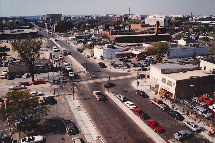
A most interesting and welcome present arrived in my inbox recently: a reader passed along four photos taken in 1990 or 1991 shot from what clearly is the old Defense Mapping Agency/National Geospatial Intelligence Agency building at 1st and M, looking out over the streetscape of a veeery different neighborhood than what exists today. It was during the construction of the Navy Yard Metro station, and you'll see what a war zone M Street was for drivers and pedestrians.
There's familiar sites from the early days of my photo archive--Normandie Liquors, the On Luck Cafeteria, Capper/Carrollsburg, the school buses at Canal Park, and more, but there's also landmarks I either never got to photograph (like the old Tracks nightclub at 80 M) or only barely caught (like the Aamco station at New Jersey and M). The Ellen Wilson apartment blocks just north of the freeway on 6th Street are even visible.
So, check out the photos! Now!
But don't stop with the color photos at the top of the page. The rest of the page has a series of overhead images from the Library of Congress archive, taken in 1992, showing many of the same locations as the "new" color shots, along with some other spots, matched where possible with my images of the not-yet demolished buildings. I posted them almost two years ago, but I'm sure they're new to plenty of people.
If you happen to have taken any photos of the neighborhood from pre-2003 that you'd like to share, I'd love to see them. Feel free to pass them along via whatever venue you might prefer--Facebook, e-mail (dc at jdland dot com), Flickr link, etc.
|
Comments (4)
|
A few weeks back I posted a bunch of photos of the progress on Canal Park, all taken by shoving my camera lens up against the cyclone fences and doing the best I could. The park's poobahs have since taken pity on me, and on Monday gave me my first chance to get inside the construction site. Alas, almost as soon as I got there, the sunny day turned into a cloudy day, and so the photos don't exactly pop off the screen. But, as I've said before, sometimes you have to take photos with the weather you have, not with the weather you wish you'd have.
The entire gallery is here, and also includes some shots from up above the park site, from when the sun was still out. (Yes, I'm bitter. If you want to see exactly what sort of impact sun vs. no-sun has on photos, I point you to my newly updated gallery of before-and-afters from L Street on the east side of the park. Bleccch.)
Some items of note I learned during this walkaround:


* (Left) The block of L Street SE within the park's footprint will be permanently reopening to traffic before too long. But at about the same time, K Street will close within the park so that it can receive the same traffic-calming streetscape seen on L. I asked about pedestrian space along L during K's closure, and they will be looking at it.
* (Middle) The interior build-out has begun of the Park Tavern restaurant inside the main pavilion. It's expected to open when the park does, which still seems to be on-schedule for November.
* (Right) The black refrigeration tubing for the hockey ice rink is being installed, so that when it's unseasonably warm in January, people can still skate and not swim. And if you look at the enlarged photo and wonder why the staircase seems to have two different sized steps, it's because the ones on the right will have wooden slats added to them for a "bleachers" feel for sitting and watching the skating/fountain-frolicking.
Photos from this visit have also been added to my main Canal Park project page, if you're looking for more detail beyond what's in today's gallery.
|
Comments (0)
More posts:
Canal Park, photos
|
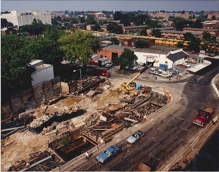
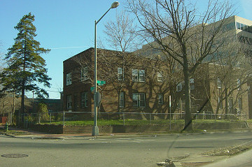
Since the demolition countdown clock is now ticking (though no one wants to commit to an actual *when*, other than "near-term"), I finally got to traipse around the 1920s-era building on Tuesday.
I took far more photos than the building probably warrants, but the historical record must be served.
Out of the torrent of images, I bring you two galleries, one of shots from inside the building's two levels (including into quite a few spots that were pitch black until my flash went off. {shiver}), and one from the walk around the exterior, since I had never gotten fence-free access to it before.
I even got to peek down into the first of the five 60-foot shafts being dug along New Jersey Avenue and then beneath the eventual I Street footprint in order to move a very big and very deep pipe. That work has to be completed before construction can begin on the Park Chelsea apartment building just to the north of the trash transfer station.
As for the station's lot once razing is complete, it could be a temporary parking lot until the eventual construction of a mixed-income apartment building that's part of the Capper-Carrollsburg redevelopment. All of this presuming that no one decides to lay in front of the bulldozers to prevent the building from being torn down.
|
Comments (2)
|
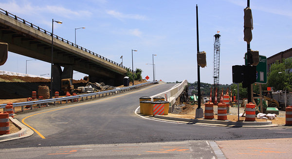
The intersection of 11th and O has changed a bit over the past few weeks: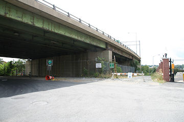
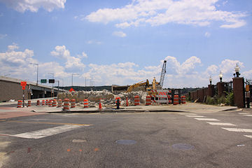
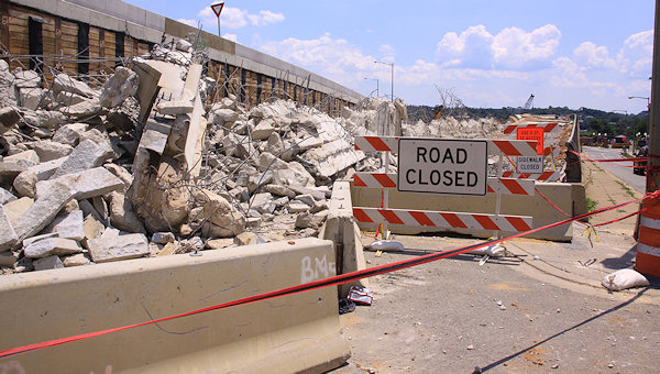 Speaking of rubble, there's no shortage of it at 11th and N (at right), where the on-ramp to the old outbound bridge is getting torn down.
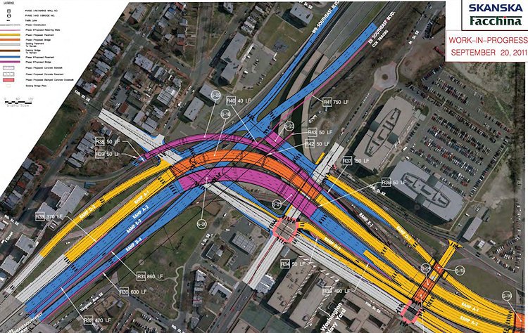 And, the wheels have started to turn on the project's second phase, with a $90 million contract awarded to Skanska/Facchina. Page 17 of the presentation packet (seen at right and here) shows in red and blue the additional ramps and movements that will be built by late 2015, including:
On the left is the old 11th and O looking south-southeast, while the picture on the right shows the new view, with the overpass for the old outbound 11th Street Bridge now a pile of rubble, and the new bridges at left and center, far more visible in person than in this low-res photo, of course. (At right is the path down to the Riverwalk, with the Navy Yard fence at far right.)
 Speaking of rubble, there's no shortage of it at 11th and N (at right), where the on-ramp to the old outbound bridge is getting torn down.
These and a number of other new photos from Sunday are now posted on my 11th Street Bridges page. The full photo archives for 11th at M, N, and O may also be of interest to construction and demolition geeks, to see exactly how much this stretch of road has changed over the past few months. (Users of the Riverwalk who haven't ventured to this spot in a few weeks might also like checking it all out.) While I finally made my first trip across the new local bridge by bike on Monday, I haven't gotten up there with a camera yet, but hope too, soon.
(If you like these sorts of disappearing-overpass images, be sure to step into the time machine to see my photos from the demolition of the South Capitol Street viaduct five years ago.)
The rest of the 11th Street bridges project continues to move forward, with the next big milestone being the opening of a new ramp on the east side of the river from southbound DC-295 to the inbound 11th Street Freeway/I-695 bridge. (Page 16 of this June 11 presentation packet says "on or about June 27" for that opening, so maybe this is going to happen really soon, though as of now there's been no announcement.) Then, sometime in the fall, the next big "missing movement" will open, which is the ramp from the outbound freeway/I-695 bridge to northbound DC-295. Following that will be ramps to and from DC-295 and the local bridge. Also in there at some point should be the new ramp from 11th Street to go westbound on the freeway, replacing the long trek down Virginia Avenue to 3rd Street for many people.
And, the wheels have started to turn on the project's second phase, with a $90 million contract awarded to Skanska/Facchina. Page 17 of the presentation packet (seen at right and here) shows in red and blue the additional ramps and movements that will be built by late 2015, including:* The new "Southeast Boulevard" that will replace the sunken part of the Southeast freeway between 11th Street and Pennsylvania Avenue, with signalized intersections at 11th Street;
* A new extension of 12th Street north of M to allow traffic exiting I-695 to continue north to the new Southeast Boulevard and then turn right to go to Pennsylvania Avenue/Barney Circle or left to 11th Street;
* A new flyover ramp from the eastbound Southeast Freeway to outbound I-695, adding an additional lane of volume and presumably being built at the same level as the new inbound flyover, which will allow the taller old outbound flyover to be demolished;
* Additional lanes on northbound 11th between M and the new Southeast Boulevard interchange;
* And probably a few other items that are hard to discern in the drawing.
As I posted a few weeks ago, the new Anacostia Waterfront web site mentions that an environmental review will be coming this fall of a combined Barney Circle/Southeast Boulevard Project that will "reconstruct Barney Circle from a misnomer into a true traffic circle, while transforming the easternmost dead-end section of the Southeast/Southwest Freeway into a boulevard between the circle and 11th Street, SE." It also describes the Southeast Boulevard reconstruction as "converting the roadway from a below-grade freeway into a four-lane at-grade boulevard with a green median and adjacent new multi-use trail to allow bicycle and pedestrian travel not currently possible in this area."
(You know what would be keen? If the improvements to Virginia Avenue that CSX is looking at post-tunnel construction would include bike lanes all the way to Virginia Avenue Park, which could then maybe hook up with some sort of bike path across the north side of the park to 11th Street, where it would then access the Southeast Boulevard trail. Then there'd be a complete bike route from Barney Circle and points north on the Anacostia Riverwalk Trail all the way to Southwest, via a one-block jog from Virginia over to I Street SE at 2nd or 3rd or 4th, since I Street will be built between 2nd and New Jersey within a few years. This also might alleviate the issues with the Navy Yard and Yards portions of the Riverwalk not really being open to bikes.)
For more information on all of this, see my project page, the AWI 11th Street Bridges section, and the latest "Eleventh Street Ledger" newsletter.
|
Comments (6)
More posts:
11th Street Bridges, photos, Southeast Blvd.
|
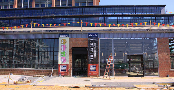
I checked out the progress at the Boilermaker Shops on Sunday, and of course have posted a slew of new images, which show some pretty striking changes to the building's exterior, including large glass panels at Bluejacket's space on Tingey near 4th, along with marketing banners to let passers-by know what's coming after the building opens later this year.
As you look at the photos, you'll see the banners for Willie's Brew and Que sports bar, Wells Dry Cleaners, Huey's 24-7 Diner, Buzz Bakery, and Bluejacket Brewery.
What you don't see, however, are banners for Austin Grill Express and brb ("be right burger"), and this is no oversight. Forest City has passed along word that the leases with Thompson Hospitality for those two food outlets have fallen through. But work continues to find replacement tenants, along with others for the spaces not yet filled.
It's still expected that the building will open later this year, although Bluejacket is aiming for an early 2013 opening.
(If you haven't gotten enough of Yards construction photos, here's the hole in the ground still being dug for Twelve12, the Teeter/apartments building at 4th and M. And bless whoever cut a few camera-sized holes in the fence along 4th Street.)
|
Comments (17)
|
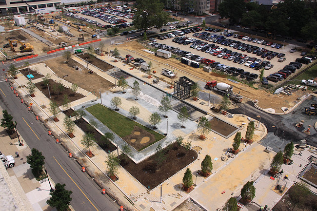
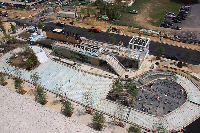
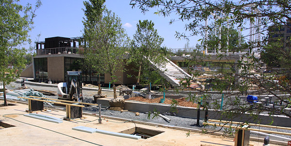
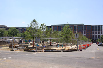
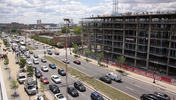
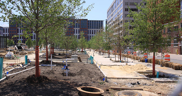 Although the temperature was a bit high for my liking, it still felt good to take a walk with camera in hand for the first time since April around Canal Park and Capitol Quarter to get a new batch of photos. And, thanks to the planting of numerous trees along with other visible improvements, my months and months of complaining about not really having much to photograph during the park's construction have come to an end.
With the arrival of the trees and some initial streetscaping now in place on the portion of L Street that runs through the park, you can now see how narrow the street is going to be in order to work to slow vehicular traffic as it crosses the park. (The completed streetscape will also give a visual cue to Slow The Hell Down.) K Street will get a similar treatment.
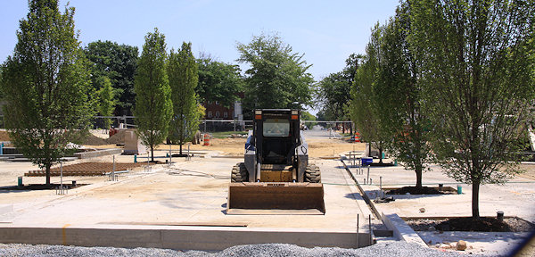
So check out the slew of progress shots on my Canal Park project page. And I do also recommend a run through my Expanded Canal Park photo archive, to make a time-traveling virtual visit to the park's three blocks, which will get you comparison shots like these:
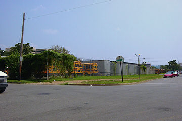
(Southeast corner of 2nd and K. I love the first shot, from nearly nine years ago, with lots of school buses and without USDOT.)
The official Canal Park web site can also give you more information, along with these slides from a presentation at last month's ANC 6D meeting. Though, judging from the people who chatted me up while I was poking my camera through the fences, we're long past the "what" stage and deep into the "when" ("WHEN!?!") stage. An opening in November is still the target.
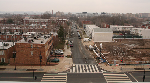
Meanwhile, on Capitol Quarter's last block, framing has now gotten underway on 4th Street, with bricking and painting finished on the houses on the 3rd Street side. My suggestion is to scroll through the Capitol Quarter Phase 2 Expanded Photo Archive, because I can't imagine at this point the before-and-afters need much narration.
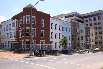
(Southeast corner of Third and L, in December 2004 [through the windshield!] and today.)
|
Comments (4)
|
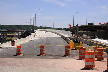
 I managed to drag myself over to 11th Street on Saturday with camera in hand to check out the new ramp that opened on Friday from M Street up to the outbound freeway bridge (which I guess we'd all better start getting used to calling I-695 East). And of course I also then had to wander down to N Street, and then to O Street, to see the progress of the work on the 11th Street Local bridge, which apparently will also be opening soon (see update below), though I've heard it will be just a "partial" opening at first.
Here's a gallery of 11th Street photos, including explanations of what's going on. The pictures also show the work underway to get the final demolition and clearing done so that 11th Street can become two-way all the way down to the new local bridge. (Though this can't happen completely until the ramp at N Street to the old outbound bridge is demolished, which is why I imagine the new bridge is only "partially" opening, enough to route outbound traffic onto it so that the final demolition can be completed.)
I also added images to my main 11th Street Bridges photo page, but you may also be interested in the more complete before-and-after sets of 11th and M, 11th and N, and 11th and O.
But there's also this view from O Street east of 11th, looking southward, which, in comparing November 2005 to now, shows one heck of a change:
Once the local bridge is open, the next big milestone will be the completion of the ramps from I-695 eastbound to DC-295 northbound, and from DC-295 southbound inbound across the freeway bridge, both of which are traffic movements that did not exist before this project. (No more dealing with the left turn on Pennsylvania Avenue, or taking New York Avenue outbound, to get to DC-295 from Near Southeast, Capitol Hill, and the Southeast Freeway.)
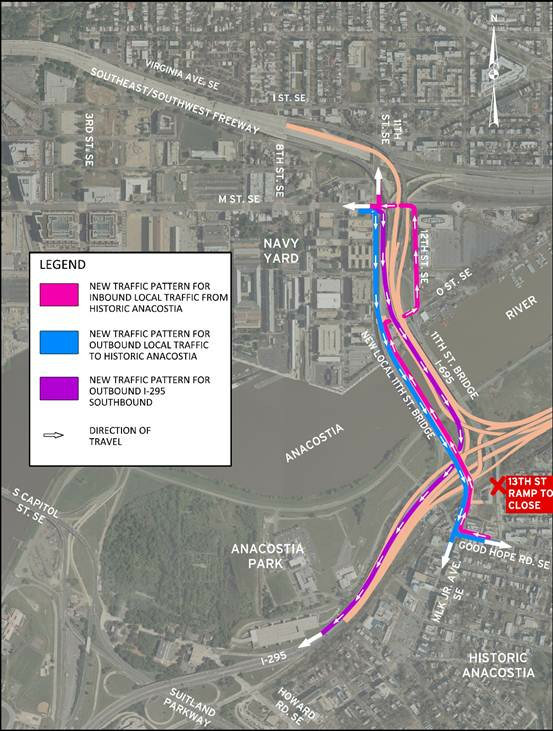
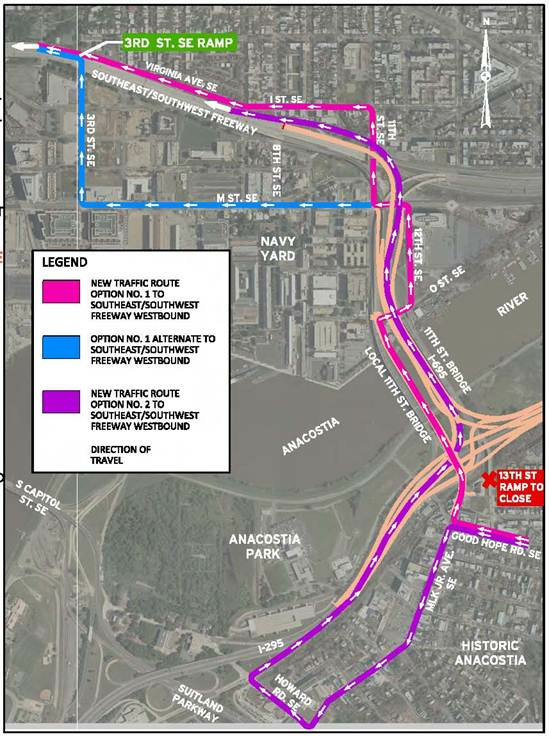 UPDATE, 5/21: DDOT has just sent out a release saying that the 11th Street Local Bridge will open "on or about Thursday, May 24." It is indeed a partial opening: "There will be 2 lanes for inbound traffic and 1 lane for outbound traffic towards Anacostia. There will also be a temporary 6-foot separated walkway for pedestrians and cyclists. (The local bridge is scheduled to be completed this fall with 4 travel lanes and a permanent shared pedestrian/bicycle path)." The release also says that the new ramp from southbound DC-295 to the inbound freeway bridge will open in about six weeks, and that the new ramp from 11th Street to the westbound SE Freeway will open by July 4. Click the two images for maps of the temporary routes and patterns.
Note that inbound traffic from the new bridge will be routed up 12th Street SE and then through the 11th and M intersection. The designs for the new bridge have always shown 11th Street becoming two-way, and the work up to M Street would seem to indicate that's still the plan, but the release doesn't say anything about the 12th Street routing being "temporary." Guess we'll have to see.
UPDATE TO THE UPDATE: Nah, as I've been saying all along (such as in Saturday's photo gallery), the 12th Street routing for inbound local bridge traffic is just temporary.
|
Comments (7)
More posts:
11th Street Bridges, photos
|
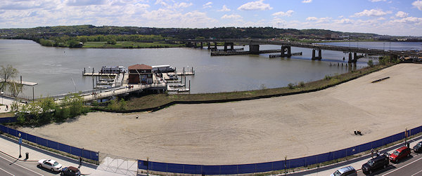
While much of my time on Opening Day each year is spent racing around getting pictures of the festivities, it's equally important to me as the first time after a multi-month lull that I can go to the various viewpoints on the upper deck and get updated photographs of how the ballpark's immediate surroundings have changed.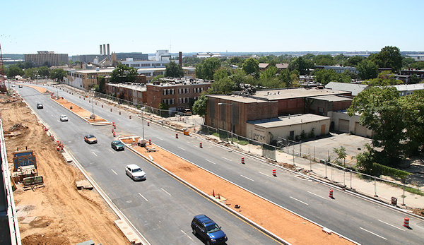
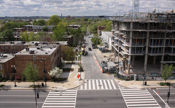
On the ballpark's western side, overlooking South Capitol Street, there's now the Camden South Capitol apartment building rising out of the ground, more than four years after the lot was cleared in preparation for construction. While technically this new 244-unit building is outside of my boundaries, I've taken enough photos of the western side of South Capitol Street over the years to maintain a pseudo-project page, where you can get the basics on the development and some before-and-afters but where I'm not going overboard in documenting the building's arrival. The photos above were taken from the ballpark's northwest viewing platform, and you can see the other images I've taken from that perch since my first visit there in September 2007.
If you want some additional views to the west, I have a series of before-and-afters from the small opening at O Street near the elevators, including these looking straight out O:
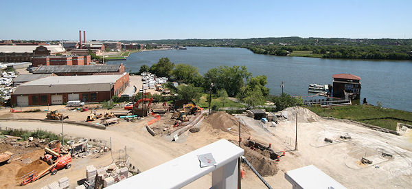
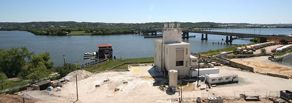
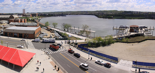
Meanwhile, on the ballpark's south side, there's two changes since last summer worth getting photos of: the completed Riverwalk bridge between Diamond Teague Park and the Yards Park, and the clearing of the Florida Rock site. And, since my 2007 "before" shots are from the time that Potomac Avenue and First Street were being reconstructed, and long before the waterfront started getting spiffed up, the transformation is pretty striking, though you can tell that I had my wide-angle lens in 2007 but had to settle for stitched-together images this time:
You can browse my many variations of these before-and-after Anacostia River views, both to the southeast and to the southwest. And, note at the top of these pages the links to other "on high" photographs from various rooftops around the neighborhood.
(PS: Apologies for the site's extended outage on Thursday--a botched move by my hosting company to upgrade the hardware of my shared server resulted in what to you was a nearly seven-hour outage but to me was the equivalent of a couple of ice ages.)
|
Comments (0)
|
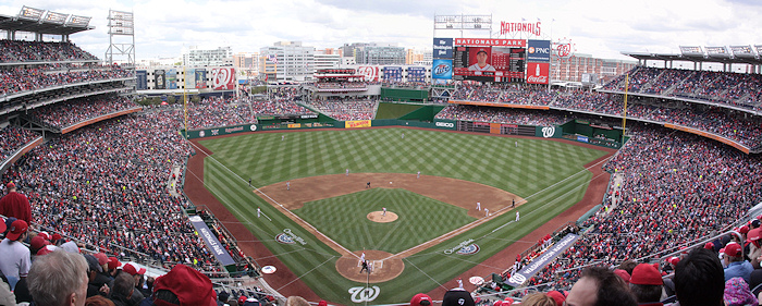
It was a little more difficult than it looked like it would be (and had a bit of a crazy finish), but the Nats got a win for their sold-out 2012 Home Opener, winning 3-2 in the 10th thanks to a wild pitch.
It's not hard in this world of social media to find photos from Opening Day, but that doesn't mean I can pass up the opportunity to post my own, for those of you who weren't there (or even if you were).
I have two galleries for you browse through: my shots from around the stadium (both looking inside and looking out), along with images from the opening ceremonies. (I leave the photos of the game itself to others.) And now I think I shall take a bit of a breather!
|
Comments (5)
More posts:
photos, Nationals Park
|
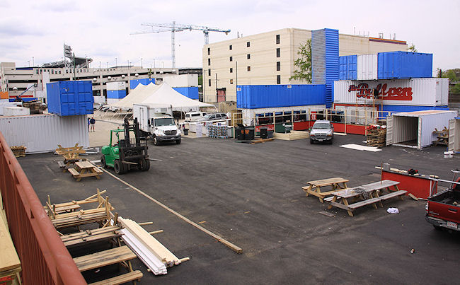
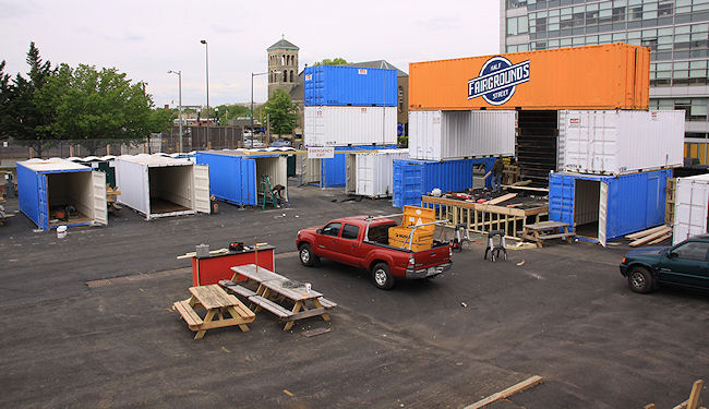
This morning I got a quick tour of the inside of the new Fairgrounds space just north of Nationals Park this morning, where the work is buzzing along to get the area ready for Thursday's Nats home opener at 1:05 pm. I talked with Bo Blair of Georgetown Events, and these are the tidbits he passed along:
* The Fairgrounds will open by 11:30 am, with about two-thirds of the footprint being used.
* There will be 10 to 12 food trucks on site.
* Three bands will play throughout the day.
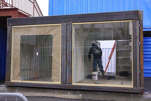 * Ten or so vendors will be set up within the containers on the north end of the block.
Blair expects to keep the larger area of the site open through Sunday (since there are games each day), at which point probably only the main area on the north end of the block (the old Das Bullpen) will be open daily until crowds pick up as the weather (and the team?) improves.
If you haven't been following along, check out my post about the new venture from when it first came to light back in February. The north end is expected to be open daily through the end of the baseball season, while the larger area will open up for bigger events (such as Truckeroo, and the DC Challenge on April 28).
In the meantime, check out the photos, while keeping in mind that it's still kind of messy, and the overcast skies weren't exactly conducive to images that "pop."
UPDATE: The lineup of food trucks: @bbqbusdc @bigcheesetruck @curbsidecupcake @DCEmpanadas @TaKorean @LobstertruckDC @TheFicelle @gofishtruckdc @Sinplicity1 @Dougthefooddude and @surfsidetruckdc. And Fairgrounds's Facebook page says these will be among the vendors: "[B]aseball inspired painters, photography, cool clothes, even baby clothes, crafts from around the world, handmade jewelry, soaps, and great produce, popcorn and pickles! in the farm stand by Half Street."
|
Comments (3)
More posts:
West Half St., Fairgrounds/Bullpen, photos
|