
|
| |||||||||||||||||||

|
Please note that JDLand is no longer being updated.
peek >>
Near Southeast DC Past News Items: meetings
- Full Neighborhood Development MapThere's a lot more than just the projects listed here. See the complete map of completed, underway, and proposed projects all across the neighborhood.
- What's New This YearA quick look at what's arrived or been announced since the end of the 2018 baseball season.
- Food Options, Now and Coming SoonThere's now plenty of food options in the neighborhood. Click to see what's here, and what's coming.
![-]()
- Anacostia RiverwalkA bridge between Teague and Yards Parks is part of the planned 20-mile Anacostia Riverwalk multi-use trail along the east and west banks of the Anacostia River.
![-]()
- Virginia Ave. Tunnel ExpansionConstruction underway in 2015 to expand the 106-year-old tunnel to allow for a second track and double-height cars. Expected completion 2018.
![-]()
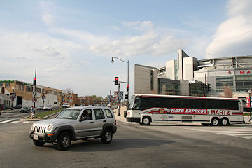
- Rail and Bus Times
Get real time data for the Navy Yard subway, Circulator, Bikeshare, and bus lines, plus additional transit information. - Rail and Bus Times
Get real time data for the Navy Yard subway, Circulator, Bikeshare, and bus lines, plus additional transit information. - Canal ParkThree-block park on the site of the old Washington Canal. Construction begun in spring 2011, opened Nov. 16, 2012.
![-]()
- Nationals Park21-acre site, 41,000-seat ballpark, construction begun May 2006, Opening Day March 30, 2008.
![-]()
- Washington Navy YardHeadquarters of the Naval District Washington, established in 1799.
![-]()
- Yards Park5.5-acre park on the banks of the Anacostia. First phase completed September 2010.
![-]()
- Van Ness Elementary SchoolDC Public School, closed in 2006, but reopening in stages beginning in 2015.
![-]()
- Agora/Whole Foods336-unit apartment building at 800 New Jersey Ave., SE. Construction begun June 2014, move-ins underway early 2018. Whole Foods expected to open in late 2018.
![-]()
- New Douglass BridgeConstruction underway in early 2018 on the replacement for the current South Capitol Street Bridge. Completion expected in 2021.
![-]()
- 1221 Van290-unit residential building with 26,000 sf retail. Underway late 2015, completed early 2018.

- NAB HQ/AvidianNew headquarters for National Association of Broadcasters, along with a 163-unit condo building. Construction underway early 2017.

- Yards/Parcel O Residential ProjectsThe Bower, a 138-unit condo building by PN Hoffman, and The Guild, a 190-unit rental building by Forest City on the southeast corner of 4th and Tingey. Underway fall 2016, delivery 2018.

- New DC Water HQA wrap-around six-story addition to the existing O Street Pumping Station. Construction underway in 2016, with completion in 2018.

- The Harlow/Square 769N AptsMixed-income rental building with 176 units, including 36 public housing units. Underway early 2017, delivery 2019.

- West Half Residential420-unit project with 65,000 sf retail. Construction underway spring 2017.
![-]()
- Novel South Capitol/2 I St.530ish-unit apartment building in two phases, on old McDonald's site. Construction underway early 2017, completed summer 2019.
![Novel South Capitol]()
- 1250 Half/Envy310 rental units at 1250, 123 condos at Envy, 60,000 square feet of retail. Underway spring 2017.
![-]()
- Parc Riverside Phase II314ish-unit residential building at 1010 Half St., SE, by Toll Bros. Construction underway summer 2017.
![-]()
- 99 M StreetA 224,000-square-foot office building by Skanska for the corner of 1st and M. Underway fall 2015, substantially complete summer 2018. Circa and an unnamed sibling restaurant announced tenants.
![-]()
- The Garrett375-unit rental building at 2nd and I with 13,000 sq ft retail. Construction underway late fall 2017.
![-]()
- Yards/The Estate Apts. and Thompson Hotel270-unit rental building and 227-room Thompson Hotel, with 20,000 sq ft retail total. Construction underway fall 2017.
![-]()
- Meridian on First275-unit residential building, by Paradigm. Construction underway early 2018.
![-]()
- The Maren/71 Potomac264-unit residential building with 12,500 sq ft retail, underway spring 2018. Phase 2 of RiverFront on the Anacostia development.
![-]()
- DC Crossing/Square 696Block bought in 2016 by Tishman Speyer, with plans for 800 apartment units and 44,000 square feet of retail in two phases. Digging underway April 2018.
![DC Crossing]()
- One Hill South Phase 2300ish-unit unnamed sibling building at South Capitol and I. Work underway summer 2018.
![One Hill South Phase 2]()
- New DDOT HQ/250 MNew headquarters for the District Department of Transportation. Underway early 2019.
![New DDOT HQ]()
- 37 L Street Condos11-story, 74-unit condo building west of Half St. Underway early 2019.
![37 L Condos]()
- CSX East Residential/Hotel225ish-unit AC Marriott and two residential buildings planned. Digging underway late summer 2019.
![CSX East Residential/Hotel]()
- 1000 South Capitol Residential224-unit apartment building by Lerner. Underway fall 2019.
![1000 South Capitol Residential]()
- Capper Seniors 2.0Reconstruction of the 160-unit building for low-income seniors that was destroyed by fire in 2018.
![1000 South Capitol Residential]()
- Chemonics HQNew 285,000-sq-ft office building with 14,000 sq ft of retail. Expected delivery 2021.
![1000 South Capitol Residential]()


194 Blog Posts Since 2003
Go to Page: 1 | 2 | 3 | 4 | 5 | 6 | 7 | 8 | 9 | 10 ... 20
Search JDLand Blog Posts by Date or Category
Go to Page: 1 | 2 | 3 | 4 | 5 | 6 | 7 | 8 | 9 | 10 ... 20
Search JDLand Blog Posts by Date or Category
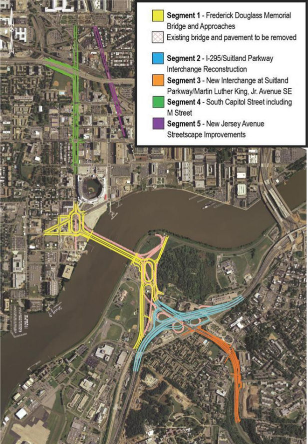
 If you are looking for some light Christmas reading, you can sit down by the fireplace with all 335 pages (plus appendices!) of the newest revision to the plans for reconfiguring much of South Capitol Street, including the construction of a new Frederick Douglass Bridge.
This document, technically known as the Supplemental Draft Environmental Impact Statement (SDEIS), describes the new "revised preferred alternative" (RPA) design that tweaks the original preferred alternative in the Final EIS released back in 2011.
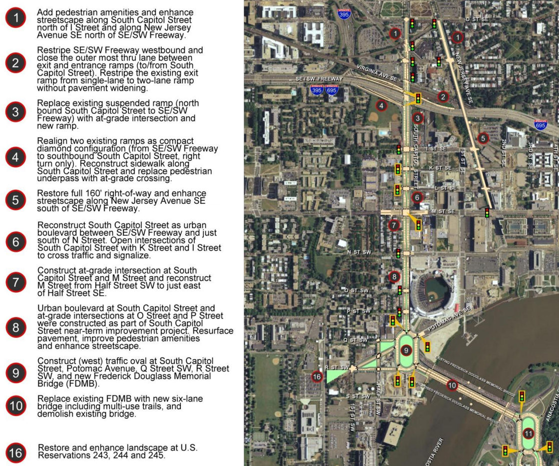
The bullet points for what the project plans are north/west of the Anacostia River are in the graphic at right (click to enlarge). The changes in this new RPA include:
* Changing the design of the bridge from a moveable span to a fixed-span bridge, which would save approximately $140 million in construction costs;
* Shifting the orientation of the new Douglass Bridge to an alignment parallel to the existing bridge, 30 feet down river, which avoids the need and lengthy process to acquire some land from Joint Base Anacostia-Bolling as well as a number of expensive relocation and reconstruction issues that a new alignment avoids (see page 2-91 of the SDEIS for details);
* A slight reduction of the size of the traffic oval on the western side (at Potomac Avenue):
* Replacing the previously designed circle on the eastern approach with an oval, located entirely in the DDOT right-of-way;
* And several other changes on the east side of the project that I will leave to others to discuss in detail. (See page ES-6 of the SDEIS.)
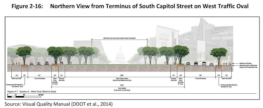 The initial design of the ovals and of the bridge itself were met with some consternation during this revision process. The SDEIS notes that in response to these concerns, DDOT has created a "Visual Quality Manual" for the project, which identifies design goals that are to "reflect the vision of providing a grand urban boulevard, which will be a gateway into the nation's capital, an iconic symbol of the District's aspirations in the 21st century, and a catalyst to revitalize local neighborhoods and the Anacostia Waterfront." (page 2-26).
 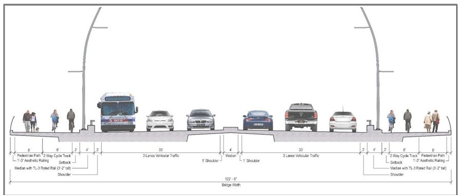 As for the bridge itself, the version in this RPA will support three travel lanes in each direction, along with 18 feet of bicycle and pedestrian paths on *both* sides of the bridge--an 8-foot lane for pedestrians and a 10-foot birdirectional bike path. (Enlarge the image at right to see that I'm not lying about the bike/ped stuff.)
And the design of the bridge is to "make its primary aesthetic impact through its position (alignment), and the shape and sizes of its structural elements" and is to " aesthetically appear to be part of a continuous urban corridor." This includes the avoidance of "using elements, solely for aesthetic effect, which do not contribute to the support of the bridge." (page 2-28)
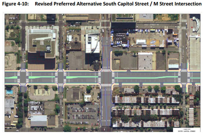
Plans for the reconfiguration of South Capitol Street as a "grand urban boulevard" have all along called for changing the intersection of South Capitol and M streets to an "at-grade intersection" (page 4-79), which would also mean that K and L would have signalized four-way intersections with South Capitol, unlike today. The wide median seen south of N would be established on the north end of the street as well, now all the way to D Street SE in the RPA. Also changing in this new plan are a few new left-turn options at I Street SE/SW and L Street SE.
 Revisions have also been made to the ramps from South Capitol Street to I-395 and I-695, but the basics from the original plans remain, most notably the demolition of the existing suspended ramp from northbound South Capitol to the SE/SW Freeway.
Even with the revisions made to cut the costs of the new Douglass Bridge, this isn't a cheap project. The five phases together are anticipated to cost over $1 billion, with Segment 1, including the new bridge and traffic ovals, estimated at $480 million. The "grand boulevard"-izing of South Capitol Street is estimated at $153 million, and planned streetscape improvements to New Jersey Avenue between D and M streets SE at $42 million, plus another $358 million in east-of-the-river improvements (page 2-11).
Worn out yet? I sure am! (I've mostly lost track of how much of this is truly even "new" news at this point.) But perhaps you can regain your strength by Jan. 22, 2015, when the public meeting on this SDEIS will be held from 6:30 to 8:30 pm at Matthews Memorial Baptist Church Fellowship Hall, 2616 Martin Luther King Ave., SE. The public comment period is running until Feb. 2. DDOT is also still amidst the design/build proposal process, with proposals expected sometime in the spring.
The SouthCapitolEIS.com web site is now focused mainly on this SDEIS, of which clearly I've just scratched the surface; you can slog through my piles of posts on all of this over the years for the historical rundown.
UPDATE: Here's the WashCycle take on the latest plans, from a bike/ped perspective.
|
Comments (5)
More posts:
Pedestrian/Cycling Issues, meetings, M Street, South Capitol St., Douglass Bridge, Traffic Issues
|
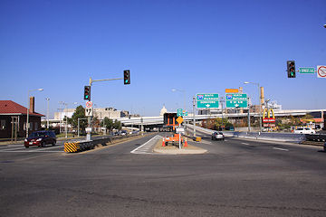
 A community meeting is on tap for Thursday (tomorrow), Dec. 11, to discuss the future Southeast Blvd., specifically the ideas emerging from the neighborhood study currently being spearheaded by ANC 6B, the Office of Planning, and DDOT.
The meeting is from 7 to 9 pm at Friendship Chamberlain Elementary School, 1345 Potomac Ave., SE, across from the Jenkins Row Harris Teeter.
Councilmember Tommy Wells will be there, and will be part of the discussion on how to best integrate into the neighborhood this road that will run from Barney Circle to the new intersection at 11th Street, SE, along the path of the old sunken portion of the Southeast Freeway.
A "temporary" version of the road is opening in early 2015, and residents have been concerned both about this becoming the de facto new version of the road, a feeling that came on the heels of the original new designs put forth by DDOT, that were basically replacing an old freeway with a new freeway, albeit it one that has a stoplight at 11th Street rather than just a free-and-clear approach to the Southeast Freeway. After those designs were released, with a push from Wells, the Office of Planning stepped in to help shepherd a neighborhood study--initial design concepts were unveiled back in August, and this week's meeting is to continue the process of refining the possibilities.
(And I am well aware that I have completely failed at keeping up with photographs of that area of 11th and of the work underway on the temporary road. All of the construction there, and the futzing with the traffic flow configuration of 11th Street while work continues around it, have made me very cranky about going over there to take pictures. Maybe this will finally spur me.)
|
Comments (4)
More posts:
meetings, Southeast Blvd., Traffic Issues
|
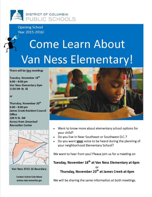 As part of the path toward the planned reopening next fall of Van Ness Elementary School at 5th and M streets, SE, DCPS has scheduled public meetings on Nov. 18 and Nov. 20 for residents in Near Southeast and Southwest to learn about the plans for the school, and to be able to provide feedback on those plans.
These sessions follow a meeting back in September between parents' groups and Dr. Nathaniel Beers, DCPS's head of specialized instruction, in which the parents were displeased with some of the information coming from the school system, specifically the plans to not have a principal in place during the planning process, and also DCPS's intent to open the school with only two PK-3 and two PK-4 classrooms, and no kindergarten.
A subsequent communication from Dr. Beers to the Van Ness Parents Group indicated, however, that an "Executive Director" will be put in place in early 2015, a person "whose primary responsibilities are to functioning as the leader of Van Ness, including engaging deeply with future parents and community members and actively recruiting students to ensure Van Ness opens fully enrolled."
In addition, the plea from parents for kindergarten offerings in the initial 2015-16 school year was not fully ignored, with DCPS agreeing to review community analysis data again before making a final decision. This has the parents' group working hard to find kindergarten-age children who could be sent to Van Ness in 2015.
These meetings should also have some information on the School Improvement Team process for the school going forward.
The meeting schedule:
* Tuesday, Nov. 18, from 6 to 8 pm, at Van Ness Elementary; and
* Thursday, Nov. 20, from 6 to 8 pm at the James Creek Resident Council Office, 100 N St. SW.
|
Comments (0)
More posts:
meetings, Van Ness Elementary
|
 I'm not sure how many people made this afternoon's meeting on the SE/SW Transportation Improvement Study (I sure didn't thanks to that 4 pm start time), but apparently there is a web site devoted to the project, and the meeting materials are posted there: seswdc.com.
This study is actually an Environmental Assessment, meaning there are very specific structures and steps that DDOT will be following.
Its stated purpose is "to develop a premium transit system that improves transportation capacity, connectivity, mobility, and safety through an integrated, multimodal transportation corridor" across Near Southeast, Southwest, and the Anacostia Historic District.
Also, the study is to address "east-west transportation needs between the Southeast and Southwest Washington communities of Anacostia and the Waterfront."
 One tidbit in the materials that may be news to people: If streetcars are chosen as the area's "premium transit mode," there will be a need for storage and/or maintenance, and so this Environmental Assessment "will review and analyze potential sites for a Streetcar facility."
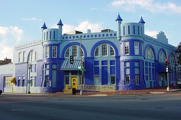
 Eight potential sites meeting the initial minimum requirements have been identified: three near M Street, SW, three at Buzzard Point, and two along 7th Street, SE, including, believe it or not, the Blue Castle, aka the Navy Yard Car Barn, where streetcars were stored and maintained during the many years they ran through the city before being shut down in the early 1960s.
A second public meeting is expected in early 2015, with the draft Environmental Assessment and associated public hearing in spring and the final document late in the year.
(Thanks to Josh Hart for the heads up about the web site, and no thanks to DDOT, who didn't mention it in their releases about the meeting. BAH!)
|
Comments (14)
More posts:
Pedestrian/Cycling Issues, meetings, Traffic Issues
|
 From DDOT: On Wednesday, Oct. 22, DDOT and the Federal Highway Administration will be holding a public meeting to discuss the Southeast/Southwest Transportation Improvement Study and Environmental Assessment, which is actually now a formal NEPA study (hence the presence of FHWA).
 Officially, "The purpose of the study is to develop a premium transit system that improves transportation capacity, connectivity, mobility, and safety."
This is an off-shoot of the first M Street SE/SW study from 2011 and 2012 as well as the subsequent Special Events transportation study that was completed earlier this year. In other words, the study after the study after the study.
The meeting will be held at at Van Ness Elementary at 4 pm (! - I asked if that was a typo, and was told no). DDOT's announcement of the meeting says that "the public will be provided an opportunity to discuss the transportation issues and potential solutions that will be addressed in the study."
|
Comments (5)
More posts:
meetings, Traffic Issues
|
 The second public meeting about the Virginia Avenue Tunnel Final Environmental Impact Statement has now been scheduled for 6:30 pm on Thursday, July 31, at the Capitol Skyline hotel at South Capitol and I streets, SW.
The release from the tunnel folks says that this meeting "will include a presentation responsive to input by citizens from the public meeting held on July 1, 2014 with a question and answer period focused on the July 1 input."
This is the additional meeting sought by DC delegate Eleanor Holmes Norton, along with the extension of the comment period from 30 to 60 days.
The official web site has the presentation and boards from the July 1 meeting.
I already posted the video animation released to show how the construction would go, and now I see this additional video showing the completed east and west portals (entrances) to the tunnel, along with how Virginia Avenue is expected to look after construction is finished.
|
Comments (4)
More posts:
CSX/Virginia Ave. Tunnel, meetings
|
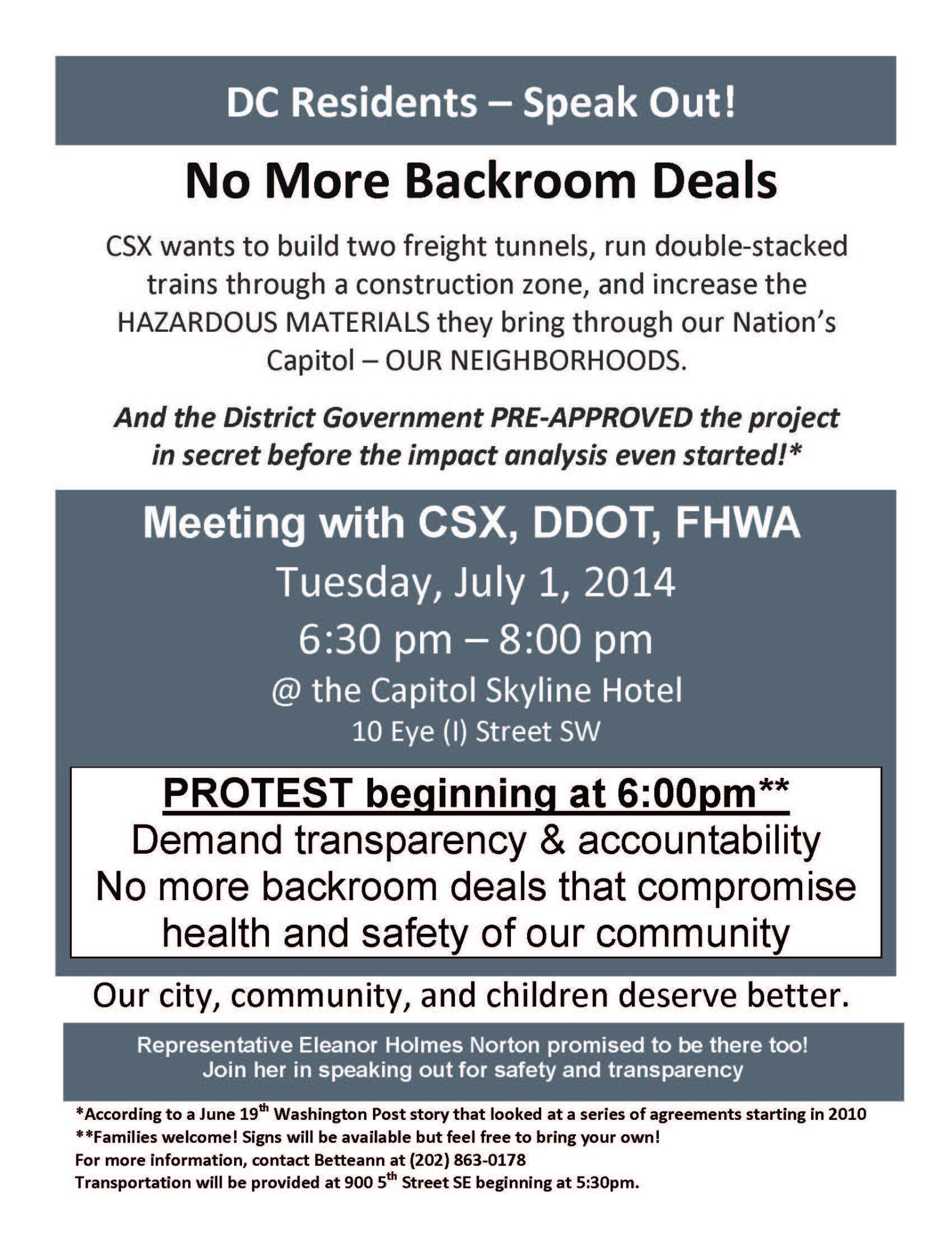
 A gentle reminder that the public meeting to discuss the Final Environmental Impact Statement for the Virginia Avenue Tunnel is tonight (July 1) at 6:30 pm at the Capitol Skyline Hotel at South Capitol and I Streets, SW.
It will no doubt be your garden variety public meeting--residents filling the seats and asking pointed questions, public officials carefully making well-vetted statements, consultants scurrying around the perimeter consulting, and opponents protesting out front beforehand.
UPDATE: Before the meeting even gets off the ground, DC Del. Eleanor Holmes Norton has announced that USDOT has agreed to extend the comment period from 30 to 60 days (though she had asked for 90) and to hold a second public meeting before the end of the review period.
|
Comments (1)
More posts:
CSX/Virginia Ave. Tunnel, meetings
|
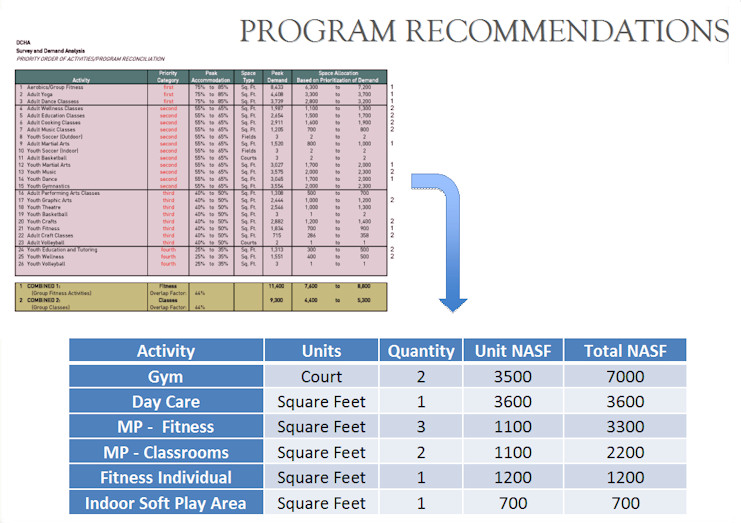 At a public meeting on Wednesday night, the team working with the DC Housing Authority unveiled what programs the consultants will be recommending be offered at the Capper community center, a list that grew out of the recent survey about residents' wishes.
 The recommendations are:
* A 7,000-square-foot gymnasium with basketball court that can also be divided into two smaller courts when needed;
* A 3,600-square-foot day care center, which would also include a secured outdoor play area;
* Three multipurpose fitness rooms (for yoga classes or the like):
* Two multipurpose classrooms;
* One individual fitness area, which could include treadmills and weights; and
* A small "soft play area" for little kids.
The recommendations are not a written-in-stone marching order, however. Soon the Housing Authority will be putting out an RFP to find the organization that will run the community center (though apparently we're now calling it a "community building," because #branding). The operator would then have "flexibility" in what it offers, while ostensibly guided by the survey results.
There were 473 responses to the survey, and the meeting slides show both the demographic breakdown of respondents as well as the top vote-getters in both fitness and "enrichment" activities.
The slides also include conceptual drawings of how the two-story building could be laid out to handle the recommended offerings, though it was stressed that the operator will be making the final decisions on layout and whatnot. (You may remember that there was at one time a basement planned for the building, but it's now been removed from the design.)
Attendees at the meeting did not rise up in fire-breathing opposition to the presentation, though concerns were raised about the lack of garden space, the seeming preference of fitness activities over learning/cultural/enrichment activities, and the need for space and kitchen access to accommodate private events like kids' birthday parties.
Even though the consultant's report is due to DCHA next week, the team still wants to hear comments, if you've got them.
The slides also said that the groundbreaking for the building is "about to happen," which of course translates to JDLand Speak as "Any Minute Now."
|
Comments (4)
More posts:
Capper, Community Center, meetings
|
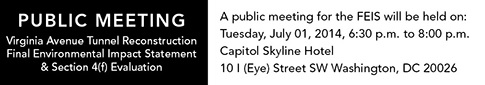 Word is hitting the streets that the public meeting for the Virginia Avenue Tunnel's Final Environmental Impact Statement is scheduled for July 1, from 6:30 pm to 8:00 pm at the Capitol Skyline Hotel. Presumably the actual document will be available before then...?
|
Comments (11)
More posts:
CSX/Virginia Ave. Tunnel, meetings
|
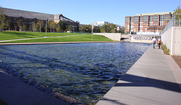 * FILLING WATER: After the flooding a few weeks ago took out the pumps, the Yards Park folks are now reporting that the basin is starting to be re-filled. Though it's still in a testing phase, officials are optimistic that the wait is almost over and the basin and fountains should be back in operation soon.
* MANAGING WATER: The EPA has released the case study about Canal Park entitled Integrating Stormwater Management and Public Amenities through a Public-Private Partnership, saying that the park "exemplifies how a public-private partnership can be used to create a public amenity that enhances the community and provides environmental benefits."
* FRONTING WATER: I came *thisclose* to posting a link that just popped up in my RSS reader about how the developers of the Florida Rock site just said that they expect to begin construction on Phase I of RiverFront on the Anacostia in "mid-2014"--but then I thought to look at the date on the release, and it was May 7. So I guess could still technically be considered news, but we're now reaching "mid-2014" with no sign of movement....
* CROSSING WATER: A reminder that tonight at 6:30 is your chance to meet the four finalists in the Bridge Park design competition. The event is at 1801 Mississippi Ave., SE.
And in the No Water Connection At All Department:
* COMMUNITY CENTER: Tomorrow night, Wednesday, June 11, is the public meeting on the results of the Capper Community Center survey.
* VAN NESS: Greater Greater Education looks at the drive to reopen Van Ness Elementary School.
(and no, the headline isn't a typo)
|
Comments (2)
More posts:
bridgepark, Canal Park, Community Center, Florida Rock, meetings, Van Ness Elementary, Yards Park
|
194 Posts:
Go to Page: 1 | 2 | 3 | 4 | 5 | 6 | 7 | 8 | 9 | 10 ... 20
Search JDLand Blog Posts by Date or Category
Go to Page: 1 | 2 | 3 | 4 | 5 | 6 | 7 | 8 | 9 | 10 ... 20
Search JDLand Blog Posts by Date or Category