
|
| |||||||||||||||||||

|
Please note that JDLand is no longer being updated.
peek >>
Near Southeast DC Past News Items: Pedestrian/Cycling Issues
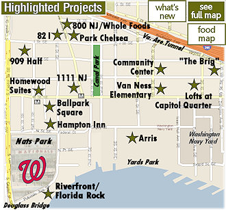
- Full Neighborhood Development MapThere's a lot more than just the projects listed here. See the complete map of completed, underway, and proposed projects all across the neighborhood.
- What's New This YearA quick look at what's arrived or been announced since the end of the 2018 baseball season.
- Food Options, Now and Coming SoonThere's now plenty of food options in the neighborhood. Click to see what's here, and what's coming.
![-]()
- Anacostia RiverwalkA bridge between Teague and Yards Parks is part of the planned 20-mile Anacostia Riverwalk multi-use trail along the east and west banks of the Anacostia River.
![-]()
- Virginia Ave. Tunnel ExpansionConstruction underway in 2015 to expand the 106-year-old tunnel to allow for a second track and double-height cars. Expected completion 2018.
![-]()
- Rail and Bus Times
Get real time data for the Navy Yard subway, Circulator, Bikeshare, and bus lines, plus additional transit information. - Rail and Bus Times
Get real time data for the Navy Yard subway, Circulator, Bikeshare, and bus lines, plus additional transit information. - Canal ParkThree-block park on the site of the old Washington Canal. Construction begun in spring 2011, opened Nov. 16, 2012.
![-]()
- Nationals Park21-acre site, 41,000-seat ballpark, construction begun May 2006, Opening Day March 30, 2008.
![-]()
- Washington Navy YardHeadquarters of the Naval District Washington, established in 1799.
![-]()
- Yards Park5.5-acre park on the banks of the Anacostia. First phase completed September 2010.
![-]()
- Van Ness Elementary SchoolDC Public School, closed in 2006, but reopening in stages beginning in 2015.
![-]()
- Agora/Whole Foods336-unit apartment building at 800 New Jersey Ave., SE. Construction begun June 2014, move-ins underway early 2018. Whole Foods expected to open in late 2018.
![-]()
- New Douglass BridgeConstruction underway in early 2018 on the replacement for the current South Capitol Street Bridge. Completion expected in 2021.
![-]()
- 1221 Van290-unit residential building with 26,000 sf retail. Underway late 2015, completed early 2018.

- NAB HQ/AvidianNew headquarters for National Association of Broadcasters, along with a 163-unit condo building. Construction underway early 2017.

- Yards/Parcel O Residential ProjectsThe Bower, a 138-unit condo building by PN Hoffman, and The Guild, a 190-unit rental building by Forest City on the southeast corner of 4th and Tingey. Underway fall 2016, delivery 2018.

- New DC Water HQA wrap-around six-story addition to the existing O Street Pumping Station. Construction underway in 2016, with completion in 2018.

- The Harlow/Square 769N AptsMixed-income rental building with 176 units, including 36 public housing units. Underway early 2017, delivery 2019.

- West Half Residential420-unit project with 65,000 sf retail. Construction underway spring 2017.
![-]()
- Novel South Capitol/2 I St.530ish-unit apartment building in two phases, on old McDonald's site. Construction underway early 2017, completed summer 2019.
![Novel South Capitol]()
- 1250 Half/Envy310 rental units at 1250, 123 condos at Envy, 60,000 square feet of retail. Underway spring 2017.
![-]()
- Parc Riverside Phase II314ish-unit residential building at 1010 Half St., SE, by Toll Bros. Construction underway summer 2017.
![-]()
- 99 M StreetA 224,000-square-foot office building by Skanska for the corner of 1st and M. Underway fall 2015, substantially complete summer 2018. Circa and an unnamed sibling restaurant announced tenants.
![-]()
- The Garrett375-unit rental building at 2nd and I with 13,000 sq ft retail. Construction underway late fall 2017.
![-]()
- Yards/The Estate Apts. and Thompson Hotel270-unit rental building and 227-room Thompson Hotel, with 20,000 sq ft retail total. Construction underway fall 2017.
![-]()
- Meridian on First275-unit residential building, by Paradigm. Construction underway early 2018.
![-]()
- The Maren/71 Potomac264-unit residential building with 12,500 sq ft retail, underway spring 2018. Phase 2 of RiverFront on the Anacostia development.
![-]()
- DC Crossing/Square 696Block bought in 2016 by Tishman Speyer, with plans for 800 apartment units and 44,000 square feet of retail in two phases. Digging underway April 2018.
![DC Crossing]()
- One Hill South Phase 2300ish-unit unnamed sibling building at South Capitol and I. Work underway summer 2018.
![One Hill South Phase 2]()
- New DDOT HQ/250 MNew headquarters for the District Department of Transportation. Underway early 2019.
![New DDOT HQ]()
- 37 L Street Condos11-story, 74-unit condo building west of Half St. Underway early 2019.
![37 L Condos]()
- CSX East Residential/Hotel225ish-unit AC Marriott and two residential buildings planned. Digging underway late summer 2019.
![CSX East Residential/Hotel]()
- 1000 South Capitol Residential224-unit apartment building by Lerner. Underway fall 2019.
![1000 South Capitol Residential]()
- Capper Seniors 2.0Reconstruction of the 160-unit building for low-income seniors that was destroyed by fire in 2018.
![1000 South Capitol Residential]()
- Chemonics HQNew 285,000-sq-ft office building with 14,000 sq ft of retail. Expected delivery 2021.
![1000 South Capitol Residential]()


 Capital Bikeshare is celebrating its 5th birthday with a free screening of the classic bicycling movie Breaking Away at the Yards Park on Saturday, Sept. 19, beginning at 7 pm.
 There will be a whole lot of swag for CaBi members, with your key fob getting you $1 off a regular cone at Ice Cream Jubilee, $1 off pints of Forbidden Planet at Bluejacket, 10% off all food orders, and 20% off drink orders at the bar at Osteria Morini, 10% off all food orders and Happy Hour pricing on drinks at Agua 301, and giveaways of Capital Bikeshare blankets and tote bags to early arriving members. (Founding members get special reserved VIP seating with their black fobs--like mine, still going!)
As for Breaking Away, it warms my heart to see this choice, because it is one of my all-time favorite movies, and is highly recommended to anyone who's never seen it. (The word "REFUND?!" is legendary in my family thanks to Paul Dooley.)
UPDATE: And I should have looked around a bit more before posting this, because it's a movie weekend at Yards Park, with Guardians of the Galaxy at 7 pm on Friday night (Sept. 18) and Romeo + Juliet on Sunday, Sept. 20 at 7 pm.
I recently took you along the multiple blocks of Virginia Avenue that are in the process of getting dug up as part of CSX's tunnel expansion and reconstruction project. But even though it's going to be a few years before the tunnels are completed, the process is underway to talk about what Virginia Avenue will look like after the construction is over.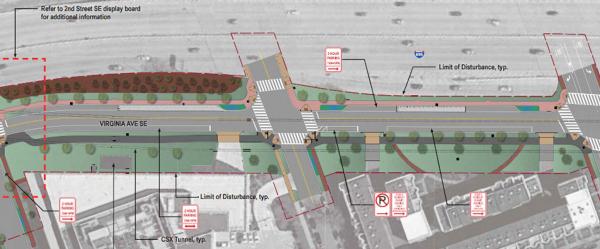
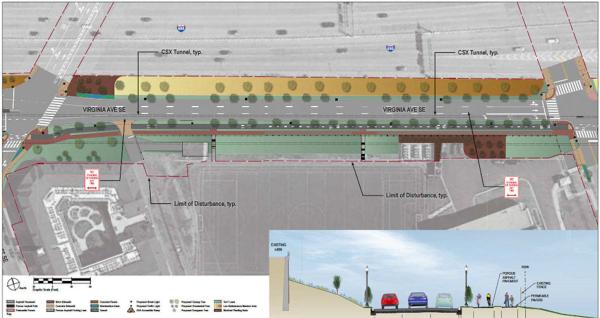

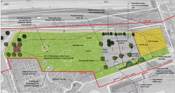 East of 9th, into Virginia Avenue Park, the path being built by CSX disappears, but the park design seen at right shows a path that runs along the north end of the park to 11th Street, where we can all dream of a day that it hooks up with the path that is supposed to be built alongside Southeast Blvd. to Barney Circle, making for an alternate route to the Anacostia Riverwalk Trail near RFK without having to go along M Street SE.
CSX is in charge of this streetscape-and-landscaping upgrade and has submitted draft plans to various groups for review, and has posted some big (BIG) PDFs on the project web site. Meanwhile, ANC 6D commissioner Meredith Fascett put out the call last week looking for volunteers to join a neighborhood working group on the restoration plans.
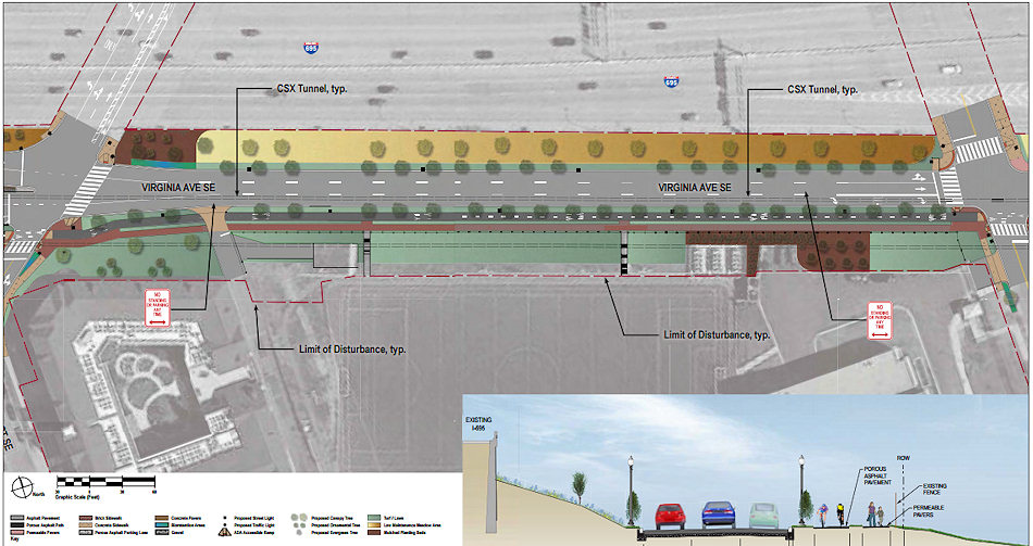
But for those who don't want to wade through the PDFs, here are some partial screen grabs of CSX's submittals for the new Virginia Avenue, and I'm sure the bike/ped paths (both shared and separate) will be of interest, along with the plans to perk up Virginia Avenue Park.
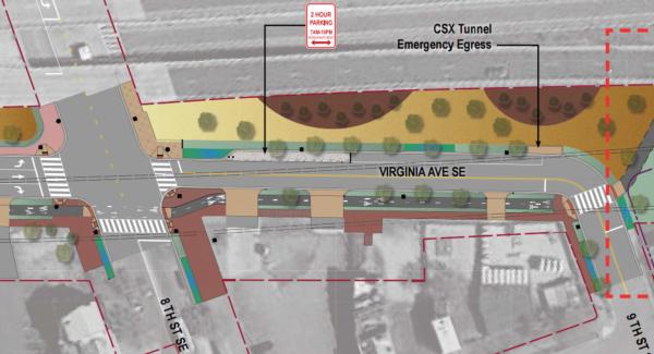
These first two screen grabs show the general landscape and "roadway" plans from 2nd to 4th Street, and from 4th to 5th (click to enlarge):
For the westernmost blocks, there will be a shared porous asphalt path on the street's south side. Then, starting at 4th Street, there will be separate asphalt bike path and a companion walking path with permeable pavers. The second image also shows the expanded pocket park between 4th and 5th that will be created thanks to the planned realignment of Virginia. Note that it also has a bike path that runs down to the I Street stub--which will make for a decent cut-over to I and its bike lanes from 3rd St. SE all the way into Southwest (well, once that little part between 2nd and New Jersey opens!).
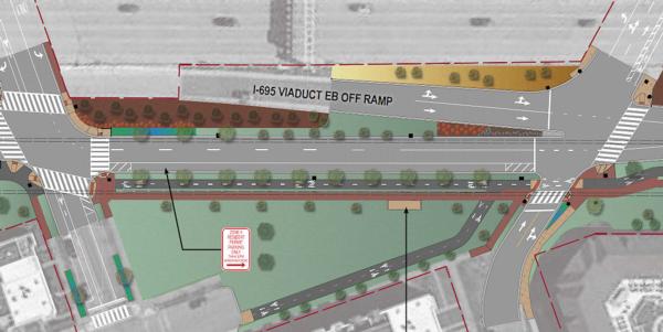
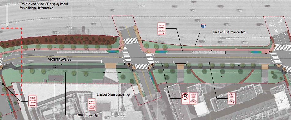
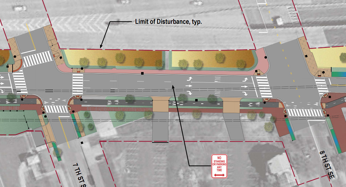
The split paths continue from 5th Street to 9th Street, as you see below (once you click to enlarge, that is):

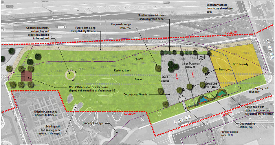 East of 9th, into Virginia Avenue Park, the path being built by CSX disappears, but the park design seen at right shows a path that runs along the north end of the park to 11th Street, where we can all dream of a day that it hooks up with the path that is supposed to be built alongside Southeast Blvd. to Barney Circle, making for an alternate route to the Anacostia Riverwalk Trail near RFK without having to go along M Street SE.
As for the park itself, the current dog park will be reconfigured, with both "large dog" and "small dog" areas. Some of the original paving stones recently uncovered will be placed in the park as well.
A public meeting to receive resident comments and feedback is expected to be happening soon, which I'm sure will be announced two minutes after I finish this post. UPDATE: Yup, less than 24 hours later, I'm seeing that the public meeting will be on Monday, Sept. 28 at 6:30, at a location to be determined.
Take a look at the full lineup of PDFs for better detail.
UPDATE, 10/7: After the meeting, updated block-by-block designs were made available (including a revision to reestablish the connection between the 400 block of I Street and Virginia Avenue), along with notes from the meeting.
|
Comments (4)
|
If I've told you about the latest below-ground happenings, and the latest above-ground happenings, I might as well come full circle and mention a few things happening right at ground level.

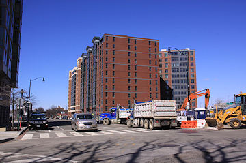
 Meanwhile, a few blocks to the north, a lovely sidewalk was laid down recently on the south side of the new one-block stretch of I Street between 2nd and New Jersey, which remains fenced off while WC Smith continues work on its Park Chelsea and 800 New Jersey apartment buildings.
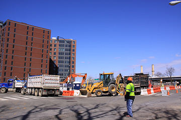
First, at the large open space along 1st Street south of M that I've taken to calling Spooky Park in honor of the former inhabitants, the beginnings of the new foot paths through what will eventually be green space on the northern end of the block are in evidence, as is the new parking lot in the southwest corner, closest to the ballpark. (Not quite so obvious at the moment is that the southeast corner, at New Jersey and Tingey, is slated to be the new home for the trapeze school.)
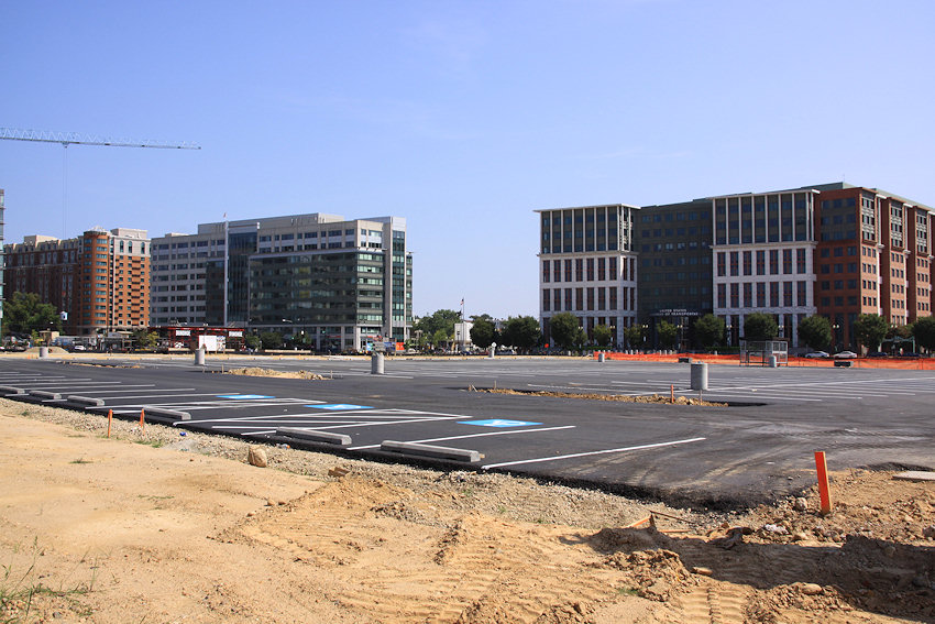
These spaces are temporary uses for the site, which is expected to eventually be where the bulk of The Yards's office space inventory will be situated, perhaps as much as 1.5 million square feet.
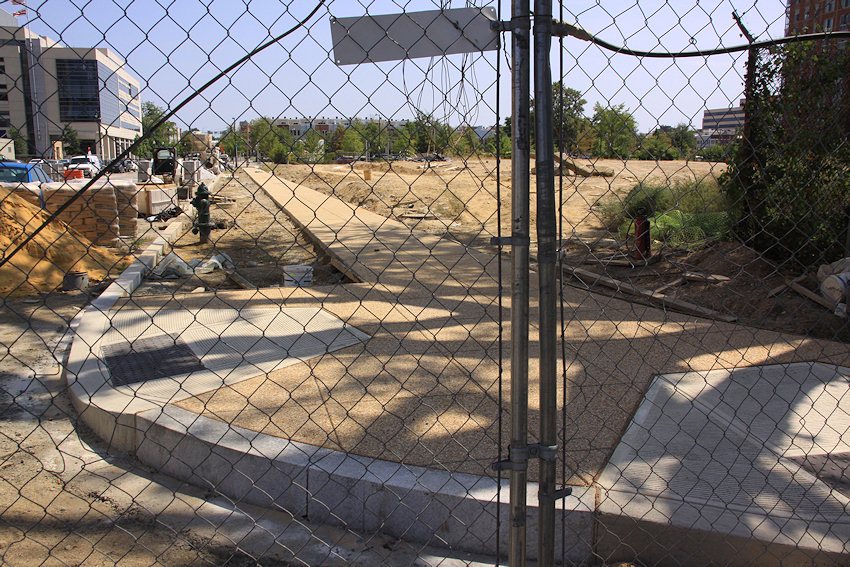 Meanwhile, a few blocks to the north, a lovely sidewalk was laid down recently on the south side of the new one-block stretch of I Street between 2nd and New Jersey, which remains fenced off while WC Smith continues work on its Park Chelsea and 800 New Jersey apartment buildings.
 Wouldn't it be keen if this lovely sidewalk could be opened for pedestrians and cyclists even while waiting for the stretch of road to come open? Especially for, say, all those neighborhood bloggers who are getting really tired of having to walk down to K Street and then back up to I Street while being tormented with the view of a fenced-off cut-through? Who will think of them??
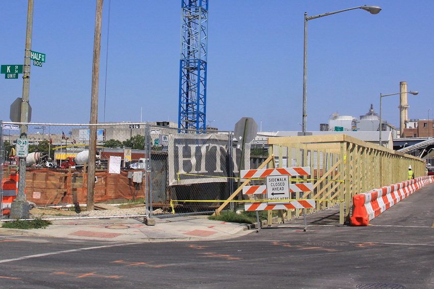
Finally, it's nice to see a covered walkway being built along the Half Street frontage of the 909 Half Mystery Building construction site. Wouldn't it be keen if one could also be built on the north side, along I Street? (Dock 79 also gets props for its new covered walkway along Potomac Avenue, one I'm sure will be used by tens of people each week, but rules are rules.)
|
Comments (0)
More posts:
Pedestrian/Cycling Issues, Parcel A/Yards
|
It's a fairly sizeable lineup of events on the neighborhood calendar over the next few days: * BIKE TO WORK DAY: The forecast looks swell for DC's annual Bike to Work Day, on Friday, May 15. Canal Park is one of the pit stops, from 7 to 9 am, at which there will be refreshments and food, plus you'll have a chance to win prizes if you have registered. (Looks like the free t-shirts are all already claimed, though.) Read about commuter convoys, ride buddies and more at the official web site.
 * BIKE TO WORK DAY: The forecast looks swell for DC's annual Bike to Work Day, on Friday, May 15. Canal Park is one of the pit stops, from 7 to 9 am, at which there will be refreshments and food, plus you'll have a chance to win prizes if you have registered. (Looks like the free t-shirts are all already claimed, though.) Read about commuter convoys, ride buddies and more at the official web site.
* FRIDAY NIGHT CONCERTS: The Friday night Summer Concert Series at Yards Park kicks off this week, with the R&B stylings of Jimi Smooth. The concerts begin each week at 6:30 pm, and the Grassy Knoll fills up pretty quickly, so arrive early!
* OPERA IN THE OUTFIELD: Saturday is Cinderella Day at Nats Park, thanks to the the return of the annual Opera in the Outfield simulcast. Gates open at 5 pm, with a slew of pre-performance activities and entertainment, including a Royal Parade that will allow "kids of all ages" to arrive in costume and march around the lower concourse. The actual simulcast begins at 7 pm, and it's all Rain or Shine, and all free and open to the public. Note that sitting in the outfield now requires a wristband handed out on a first-come first-serve basis. More details here.
* GLUG GLUG GLUG: This most assuredly is not free, but Canal Park on Saturday will host "ABV," an afternoon of "outdoor imbibing" of the "finest craft beverages," put together by Greg Engert and friends. It will run from 3 to 8 pm, rain or shine, and tickets are $20 at the door or in special advance packages. The full list of beer, wine, and spirits to be available is here.
* FITNESS IN THE FRONT: Technically not a weekend event, but you may need to toss in a workout session or two after a big weekend--and just your luck, the lineup of outside summer fitness classes gets underway on Monday, May 19. Brought to you by VIDA Fitness and DC BFIT and located in Yards and Canal Parks, the classes range from Yoga to Zumba to "high energy" to Boot Camps to a once-a-month family fitness session. The schedule is here, and classes are free and open to the public.
* MARGARITA WARS: In case you didn't get your fill of drinking in a neighborhood park at ABV, City Paper's third annual Margarita Wars is slated for May 21 at 6:30 pm at the Yards Park. "You be the judge as the region's top mixologists compete for your vote in a winner take all battle for 'rita supremacy." Tickets are $25 and include unlimited margarita tastings. Also included: one of those extra-special tequila-fueled hangovers. (But you'll want to recover by May 30, when the Tour de Fat extravaganza returns to Yards Park.)
|
Comments (1)
|
Since I unleashed the megaphone to talk about the traffic and pedestrian brouhaha I encountered at New Jersey Avenue and I Street on Saturday, it's my duty to pass along to you The Rest of the Story, at least in regard to pedestrian passage along New Jersey northward toward the freeway.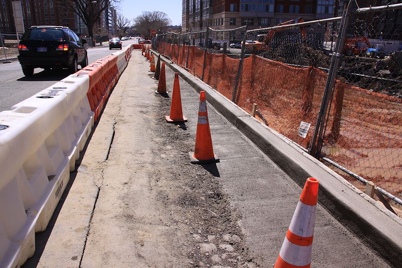
I went back on Sunday and found it much quieter, and saw at least part of the reason that the pedestrian walkway had been closed - a new curb had been built, and new concrete poured along the gutter, as you see in the photo below. I also saw evidence of the old cobblestone, as you also see in the photo.
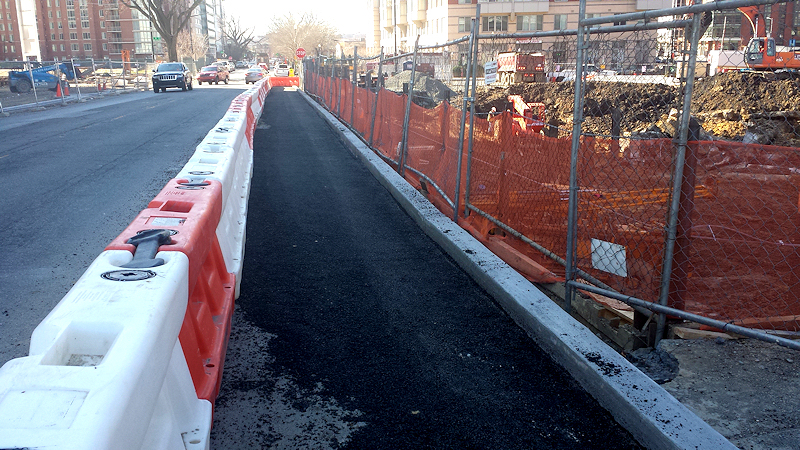
But this was apparently just the first part of a process that then resulted in new asphalt being laid down on Monday, as you see in the other photo below.
I had actually noticed last Thursday that the old asphalt was starting to show cracks and appeared to be sinking toward the new 82 I excavation, so this work was probably pretty critical.
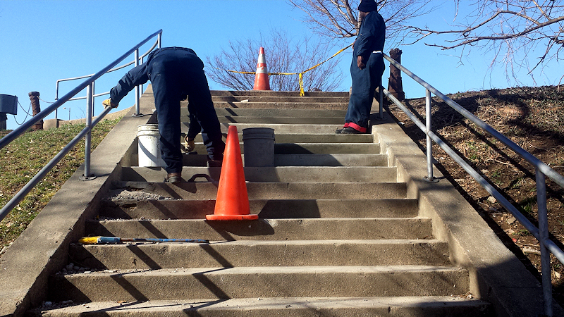
And in other good pedestrian news along New Jersey, the stairs up from/down to Garfield Park are being repaired today.
If you are interested in more conversations about the subject, a group calling itself Capitol Riverfront Citizens for Pedestrian Safety (on Twitter at @SaferWalksSEDC) is working to keep a close watch on the state of things.
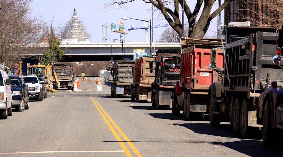
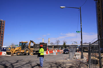
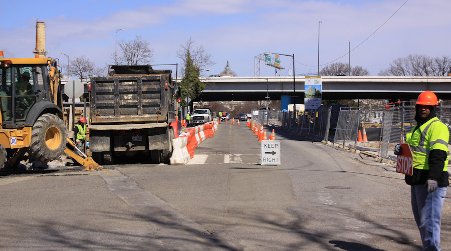 This morning broke clear and sunny, and with a full slate of photos on my agenda, I headed south down New Jersey Avenue from north of the freeway, snapping merrily along, until I came to the 82 I construction site on the northwest corner of New Jersey and I.
 With new sidewalks not yet in place in front of the Park Chelsea/800 New Jersey developments on the east side of the street, and with 82 I apparently not being covered under the regulations that resulted in the wide wide sidewalks you see all along the rest of the avenue, excavation and site work has been taking place right up to the (former) curb line on the only side of the street where pedestrians can walk. This has been going on for a few weeks, and while the temporary in-the-road-but-separated-by-plastic-barriers pedestrian path isn't optimal, it's also not unusual in these situations.
But this morning a large truck was parked in the former pedestrian path, with flagmen directing traffic in what had become just two very narrow north-south traffic lanes--and now there was absolutely nowhere for pedestrians to walk, in a location where it's very hard to take an alternate route on foot, unless you want to walk allllllll the way over to South Capitol and alllllll the way back to New Jersey once you get north of the freeway and train tracks, or backtrack southward to K so you can then walk north on 2nd or 3rd.
 I've sidestepped a lot (A LOT) of construction during my 12 years of JDLand-ing, and I am generally pretty laid back about it--I'm not walking a dog, or pushing a stroller, so I just kind of grumble and pick my way through.
 But the situation this morning--when two flagmen on either end were each telling me a different lane in the street in which to walk, and later exacerbated by seeing the line of seven or more dump trucks that were idling back to and around onto K Street while waiting to haul off excavated dirt--well, it escalated past even my high bar of tolerance, especially since I know how many people now walk along New Jersey to go to Capitol South, or the Capitol complex, or wherever.
And with the Nats returning to the neighborhood one week from today, and with thoughts of the number of stadium-goers who also do that New Jersey Avenue walk before and after games, I did the normal thing in 2015--I mentioned the situation on Twitter.
Which led to a lot of other people speaking up on Twitter, many of whom have been complaining about the issues surrounding this construction since it began back in February. Before long, Ward 6 council member Charles Allen tweeted that he had contacted the director of DDOT, and that "he's looking into it."
 And while it shouldn't be the case that residents' complaints are ignored until either a) a loudmouth blogger fires off a tweet or b) baseball arrives, the truth is that the Nats' 2015 season is going to present a lot of challenges for anyone arriving in any way other than coming out of the Metro at Half and M.
 There will be less parking available this year (which I'll detail in an upcoming post), and with 13 active construction sites east of South Capitol between the freeway and Nats Park, cars and pedestrians and bikes and fans and residents and commuters will be fighting a lot of battles, even though for the most part there won't be at gametime the sort of active work that snarled New Jersey and I this morning.
In addition to this New Jersey Avenue construction possibly bedeviling fans using Capitol South, the blocking of the sidewalk on the west side of 1st Street south of M for Ballpark Square construction in the block just north of the stadium--and the apparent temporary loss of the bike lane there as well--will end up making lots of fans just walk in the street instead of crossing back to the east side of the street, away from the ballpark.
And there are other spots where sidewalks are now blocked off or narrowed, or where street parking is temporarily banned, which are the sorts of issues that lead to grumpy drivers and grumpy pedestrians, which can lead to bad things.
One hopes that there will be attention paid to ways to ensure a safer passage to the ballpark, but one also hopes that any real effort to mitigate these construction/sidewalk/traffic/pedestrian issues doesn't happen only during the hours that red-and-white-bedecked masses are around.
In the meantime, be careful out there, and not just right where you see construction. (I watched a dump truck blow through a red light at 1st and Potomac, taking me back to the last era of crazy amounts of construction, but that was in 2007 when the resident population was about 1/10th of what it is now.)
UPDATE: One thing I should have emphasized more clearly is that this was obviously a Saturday-type operation, where the assumption is that such a setup will be less disruptive than on a weekday, and so the contractor can then get more done (in this case, hauling of dirt) in a shorter timespan. This intersection is just a tough one, since, as I said above, it doesn't easily allow for alternate north/south passage if something is going on.
UPDATE II: I went back on Sunday, where, as I expected, things were much quieter. And I also saw that part of the reason for the closure of the pedestrian walkway on Saturday was to build a new curb, and also pour some new concrete. I had noticed actually on Thursday that the old asphalt had a big crack in it and seemed to be dropping off toward the new excavation hole, so obviously this was a fix for that, and probably a pretty critical one. Note also at the bottom of the photo evidence of old cobblestone.
|
Comments (9)
More posts:
801nj, Pedestrian/Cycling Issues, Traffic Issues
|
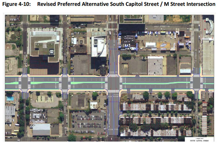
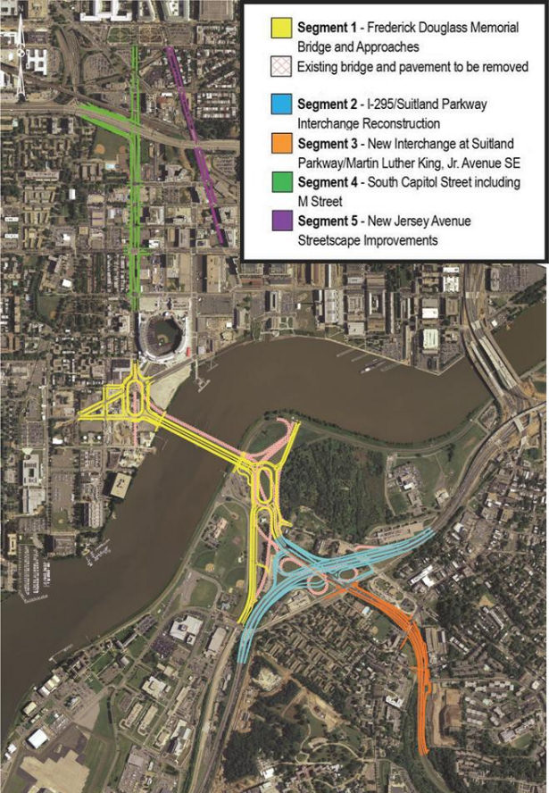
 If you are looking for some light Christmas reading, you can sit down by the fireplace with all 335 pages (plus appendices!) of the newest revision to the plans for reconfiguring much of South Capitol Street, including the construction of a new Frederick Douglass Bridge.
This document, technically known as the Supplemental Draft Environmental Impact Statement (SDEIS), describes the new "revised preferred alternative" (RPA) design that tweaks the original preferred alternative in the Final EIS released back in 2011.
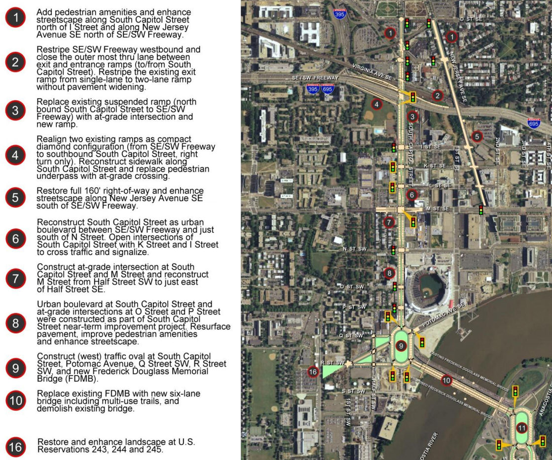
The bullet points for what the project plans are north/west of the Anacostia River are in the graphic at right (click to enlarge). The changes in this new RPA include:
* Changing the design of the bridge from a moveable span to a fixed-span bridge, which would save approximately $140 million in construction costs;
* Shifting the orientation of the new Douglass Bridge to an alignment parallel to the existing bridge, 30 feet down river, which avoids the need and lengthy process to acquire some land from Joint Base Anacostia-Bolling as well as a number of expensive relocation and reconstruction issues that a new alignment avoids (see page 2-91 of the SDEIS for details);
* A slight reduction of the size of the traffic oval on the western side (at Potomac Avenue):
* Replacing the previously designed circle on the eastern approach with an oval, located entirely in the DDOT right-of-way;
* And several other changes on the east side of the project that I will leave to others to discuss in detail. (See page ES-6 of the SDEIS.)
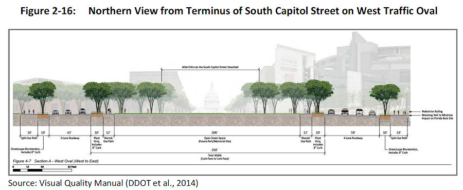 The initial design of the ovals and of the bridge itself were met with some consternation during this revision process. The SDEIS notes that in response to these concerns, DDOT has created a "Visual Quality Manual" for the project, which identifies design goals that are to "reflect the vision of providing a grand urban boulevard, which will be a gateway into the nation's capital, an iconic symbol of the District's aspirations in the 21st century, and a catalyst to revitalize local neighborhoods and the Anacostia Waterfront." (page 2-26).
 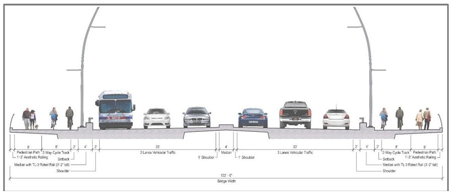 As for the bridge itself, the version in this RPA will support three travel lanes in each direction, along with 18 feet of bicycle and pedestrian paths on *both* sides of the bridge--an 8-foot lane for pedestrians and a 10-foot birdirectional bike path. (Enlarge the image at right to see that I'm not lying about the bike/ped stuff.)
And the design of the bridge is to "make its primary aesthetic impact through its position (alignment), and the shape and sizes of its structural elements" and is to " aesthetically appear to be part of a continuous urban corridor." This includes the avoidance of "using elements, solely for aesthetic effect, which do not contribute to the support of the bridge." (page 2-28)
Plans for the reconfiguration of South Capitol Street as a "grand urban boulevard" have all along called for changing the intersection of South Capitol and M streets to an "at-grade intersection" (page 4-79), which would also mean that K and L would have signalized four-way intersections with South Capitol, unlike today. The wide median seen south of N would be established on the north end of the street as well, now all the way to D Street SE in the RPA. Also changing in this new plan are a few new left-turn options at I Street SE/SW and L Street SE.
 Revisions have also been made to the ramps from South Capitol Street to I-395 and I-695, but the basics from the original plans remain, most notably the demolition of the existing suspended ramp from northbound South Capitol to the SE/SW Freeway.
Even with the revisions made to cut the costs of the new Douglass Bridge, this isn't a cheap project. The five phases together are anticipated to cost over $1 billion, with Segment 1, including the new bridge and traffic ovals, estimated at $480 million. The "grand boulevard"-izing of South Capitol Street is estimated at $153 million, and planned streetscape improvements to New Jersey Avenue between D and M streets SE at $42 million, plus another $358 million in east-of-the-river improvements (page 2-11).
Worn out yet? I sure am! (I've mostly lost track of how much of this is truly even "new" news at this point.) But perhaps you can regain your strength by Jan. 22, 2015, when the public meeting on this SDEIS will be held from 6:30 to 8:30 pm at Matthews Memorial Baptist Church Fellowship Hall, 2616 Martin Luther King Ave., SE. The public comment period is running until Feb. 2. DDOT is also still amidst the design/build proposal process, with proposals expected sometime in the spring.
The SouthCapitolEIS.com web site is now focused mainly on this SDEIS, of which clearly I've just scratched the surface; you can slog through my piles of posts on all of this over the years for the historical rundown.
UPDATE: Here's the WashCycle take on the latest plans, from a bike/ped perspective.
|
Comments (5)
More posts:
Pedestrian/Cycling Issues, meetings, M Street, South Capitol St., Douglass Bridge, Traffic Issues
|
 I'm not sure how many people made this afternoon's meeting on the SE/SW Transportation Improvement Study (I sure didn't thanks to that 4 pm start time), but apparently there is a web site devoted to the project, and the meeting materials are posted there: seswdc.com.
This study is actually an Environmental Assessment, meaning there are very specific structures and steps that DDOT will be following.
Its stated purpose is "to develop a premium transit system that improves transportation capacity, connectivity, mobility, and safety through an integrated, multimodal transportation corridor" across Near Southeast, Southwest, and the Anacostia Historic District.
Also, the study is to address "east-west transportation needs between the Southeast and Southwest Washington communities of Anacostia and the Waterfront."
 One tidbit in the materials that may be news to people: If streetcars are chosen as the area's "premium transit mode," there will be a need for storage and/or maintenance, and so this Environmental Assessment "will review and analyze potential sites for a Streetcar facility."
 Eight potential sites meeting the initial minimum requirements have been identified: three near M Street, SW, three at Buzzard Point, and two along 7th Street, SE, including, believe it or not, the Blue Castle, aka the Navy Yard Car Barn, where streetcars were stored and maintained during the many years they ran through the city before being shut down in the early 1960s.
A second public meeting is expected in early 2015, with the draft Environmental Assessment and associated public hearing in spring and the final document late in the year.
(Thanks to Josh Hart for the heads up about the web site, and no thanks to DDOT, who didn't mention it in their releases about the meeting. BAH!)
|
Comments (14)
More posts:
Pedestrian/Cycling Issues, meetings, Traffic Issues
|
If you haven't seen it, this page gives you a quick look at the status of the neighborhood's five Bikeshare stations, including the two new ones at 3rd and Tingey & 8th and Potomac, along with other nearby stations of interest. It also shows upcoming arrival times for the Green line at Navy Yard-Ballpark, the Union Station-Navy Yard Circulator bus at New Jersey and M, and Metrobus lines at New Jersey and M.
You can access this page from the "Live Transit Info" link on the JDLand home page menu bar, or by clicking the little Metro icons on the home page map. It's also available via a link from the JDLand mobile home page at m.jdland.com.
|
Comments (1)
|
The latest presentation slides from last week's 11th Street Bridges project's Community Communications Committee Meeting have been posted, and a few of them caught my eye (or bought my eye, for you fans of obscure Monty Python references). TheWashCycle recently posted a photo of the work underway on the overlooks that are now under construction just down-river of the new local bridge, using the old piers as their bases, and this is what they are expected to look like when completed (click to enlarge):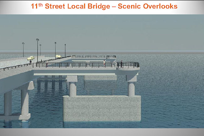
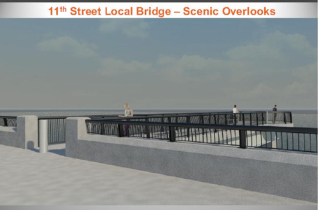
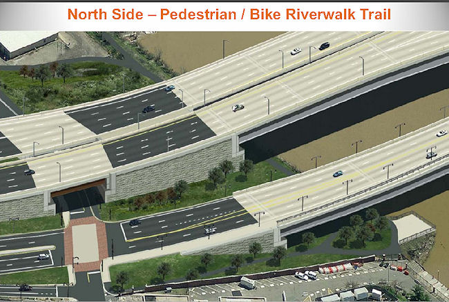 There is also a rendering (seen at right) of how the Anacostia Riverwalk Trail will run both under the bridges and down from O Street when finished; it also shows the small overlook that will be built out into the river just to the east of the entrance gate to the Navy Yard Promenade. WashCycle also got a recent photo of the path under construction, where you can see the outlines of what the rendering shows is coming.
There is also a rendering (seen at right) of how the Anacostia Riverwalk Trail will run both under the bridges and down from O Street when finished; it also shows the small overlook that will be built out into the river just to the east of the entrance gate to the Navy Yard Promenade. WashCycle also got a recent photo of the path under construction, where you can see the outlines of what the rendering shows is coming.The presentation slides also have some photos of the demolition underway on the old outbound freeway flyover, and aerial photos of the work that's completed and still underway on the east side of the river. There's also, on page 21, an image which looks like they've already almost completed the filling-in of the portion of the Southeast Freeway between 8th and 11th, since it shows dirt almost up to the underside of the existing bridge that takes 11th Street across the sunken freeway between I and L.
What all of this really means is that I need to get back to 11th Street with my camera pretty soon, since my last batch of photos is now a bit dated (waaah!).
|
Comments (11)
More posts:
11th Street Bridges, Pedestrian/Cycling Issues, riverwalk
|