
|
| |||||||||||||||||||

|
Please note that JDLand is no longer being updated.
peek >>
Near Southeast DC Past News Items: Pedestrian/Cycling Issues
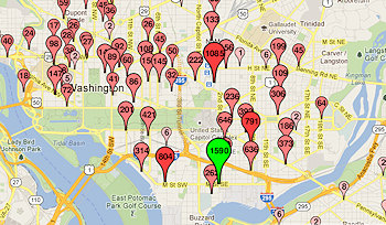
- Full Neighborhood Development MapThere's a lot more than just the projects listed here. See the complete map of completed, underway, and proposed projects all across the neighborhood.
- What's New This YearA quick look at what's arrived or been announced since the end of the 2018 baseball season.
- Food Options, Now and Coming SoonThere's now plenty of food options in the neighborhood. Click to see what's here, and what's coming.
![-]()
- Anacostia RiverwalkA bridge between Teague and Yards Parks is part of the planned 20-mile Anacostia Riverwalk multi-use trail along the east and west banks of the Anacostia River.
![-]()
- Virginia Ave. Tunnel ExpansionConstruction underway in 2015 to expand the 106-year-old tunnel to allow for a second track and double-height cars. Expected completion 2018.
![-]()
- Rail and Bus Times
Get real time data for the Navy Yard subway, Circulator, Bikeshare, and bus lines, plus additional transit information. - Rail and Bus Times
Get real time data for the Navy Yard subway, Circulator, Bikeshare, and bus lines, plus additional transit information. - Canal ParkThree-block park on the site of the old Washington Canal. Construction begun in spring 2011, opened Nov. 16, 2012.
![-]()
- Nationals Park21-acre site, 41,000-seat ballpark, construction begun May 2006, Opening Day March 30, 2008.
![-]()
- Washington Navy YardHeadquarters of the Naval District Washington, established in 1799.
![-]()
- Yards Park5.5-acre park on the banks of the Anacostia. First phase completed September 2010.
![-]()
- Van Ness Elementary SchoolDC Public School, closed in 2006, but reopening in stages beginning in 2015.
![-]()
- Agora/Whole Foods336-unit apartment building at 800 New Jersey Ave., SE. Construction begun June 2014, move-ins underway early 2018. Whole Foods expected to open in late 2018.
![-]()
- New Douglass BridgeConstruction underway in early 2018 on the replacement for the current South Capitol Street Bridge. Completion expected in 2021.
![-]()
- 1221 Van290-unit residential building with 26,000 sf retail. Underway late 2015, completed early 2018.

- NAB HQ/AvidianNew headquarters for National Association of Broadcasters, along with a 163-unit condo building. Construction underway early 2017.

- Yards/Parcel O Residential ProjectsThe Bower, a 138-unit condo building by PN Hoffman, and The Guild, a 190-unit rental building by Forest City on the southeast corner of 4th and Tingey. Underway fall 2016, delivery 2018.

- New DC Water HQA wrap-around six-story addition to the existing O Street Pumping Station. Construction underway in 2016, with completion in 2018.

- The Harlow/Square 769N AptsMixed-income rental building with 176 units, including 36 public housing units. Underway early 2017, delivery 2019.

- West Half Residential420-unit project with 65,000 sf retail. Construction underway spring 2017.
![-]()
- Novel South Capitol/2 I St.530ish-unit apartment building in two phases, on old McDonald's site. Construction underway early 2017, completed summer 2019.
![Novel South Capitol]()
- 1250 Half/Envy310 rental units at 1250, 123 condos at Envy, 60,000 square feet of retail. Underway spring 2017.
![-]()
- Parc Riverside Phase II314ish-unit residential building at 1010 Half St., SE, by Toll Bros. Construction underway summer 2017.
![-]()
- 99 M StreetA 224,000-square-foot office building by Skanska for the corner of 1st and M. Underway fall 2015, substantially complete summer 2018. Circa and an unnamed sibling restaurant announced tenants.
![-]()
- The Garrett375-unit rental building at 2nd and I with 13,000 sq ft retail. Construction underway late fall 2017.
![-]()
- Yards/The Estate Apts. and Thompson Hotel270-unit rental building and 227-room Thompson Hotel, with 20,000 sq ft retail total. Construction underway fall 2017.
![-]()
- Meridian on First275-unit residential building, by Paradigm. Construction underway early 2018.
![-]()
- The Maren/71 Potomac264-unit residential building with 12,500 sq ft retail, underway spring 2018. Phase 2 of RiverFront on the Anacostia development.
![-]()
- DC Crossing/Square 696Block bought in 2016 by Tishman Speyer, with plans for 800 apartment units and 44,000 square feet of retail in two phases. Digging underway April 2018.
![DC Crossing]()
- One Hill South Phase 2300ish-unit unnamed sibling building at South Capitol and I. Work underway summer 2018.
![One Hill South Phase 2]()
- New DDOT HQ/250 MNew headquarters for the District Department of Transportation. Underway early 2019.
![New DDOT HQ]()
- 37 L Street Condos11-story, 74-unit condo building west of Half St. Underway early 2019.
![37 L Condos]()
- CSX East Residential/Hotel225ish-unit AC Marriott and two residential buildings planned. Digging underway late summer 2019.
![CSX East Residential/Hotel]()
- 1000 South Capitol Residential224-unit apartment building by Lerner. Underway fall 2019.
![1000 South Capitol Residential]()
- Capper Seniors 2.0Reconstruction of the 160-unit building for low-income seniors that was destroyed by fire in 2018.
![1000 South Capitol Residential]()
- Chemonics HQNew 285,000-sq-ft office building with 14,000 sq ft of retail. Expected delivery 2021.
![1000 South Capitol Residential]()


After the flurry of the past few months, real news is taking a bit of a breather. In the meantime, here's some reading material I've scraped up, so that it doesn't look like I've completely quit working:
* Joel Osteen Ministries' "America's Night of Hope" is coming to Nationals Park on Saturday--here's the Washington Post's story on Osteen and the plans for the event. Doors open at 5:30 pm and the festivities start at 7 pm, if you're wanting to plan your evening around the crowds. If you're coming to the neighborhood for it, my Visiting Nats Park page can help you find your way.
* Want to know how the Nats Park field is cared for, and who takes care of it? The Post profiles head groundskeeper John Turnour and his work.
* A reader tells WashCycle about being stopped from biking on the Navy Yard portion of the Riverwalk. That promenade has always been signed as prohibiting bicycling, but with increased publicity for using the Riverwalk as a biking trail (including Tuesday's ribbon cutting of the new bridge across the CSX tracks), the issue of bicycles along the Navy Yard/Yards Park/Teague stretch is going to keep bubbling up, perhaps even moreso when the new 11th Street Local bridge opens soon with its wide pedestrian/cycling paths making the connection between both sides of the river even easier.
* Speaking of that new 11th Street Local bridge, much streetscape work has been done recently on O Street (new pavement, curbs, and brick paver crosswalks), and it looks like the concrete should be poured before too long to complete the connection from O to where the bridge begins to rise above the river. Maybe I'll actually get over there with my camera soon.
* Speaking of streetscapes, there's a new sidewalk on L Street between 1st and New Jersey, to go with the new sidewalk on Half between I and K.
* The Capitol Riverfront BID would love it if you'd fill out either their residential survey (if you live in the neighborhood) or the employee survey if you work here.
* Jonathan O'Connell at WaPo looks at how developer Opus East hit the skids, right as it was trying to finish 1015 Half Street. (Opus was also the developer behind 100 M, but it was completed before everything truly fell apart.)
* The Mayor is having a Ward 6 Fiscal Year 2013 Budget Town Hall Meeting tonight (April 25) at 6:30 pm at Eastern High School, 1700 East Capitol Street.
* The next meeting of Police Service Area 106 is on Saturday, April 28, at 10 am at the Capper Seniors building at 900 5th St., SE.
What else is going on?
UPDATE: Adding a link to Washington City Paper's profile of "The Nautical Yards", a "site-specific dance and theater piece inspired by the Washington Navy Yard" being performed at the Yards Park Thursday through Saturday (April 26-29) at 7 pm. Premium seating is $30, general admission is free.
And I should probably remind that tickets for Springsteen at Nats Park on Sept. 14 go on sale Friday (April 27) at 10 am.
|
Comments (15)
More posts:
1015 Half, 11th Street Bridges, Capitol Riverfront BID, Pedestrian/Cycling Issues, Events, riverwalk, Nationals Park, Stadium Events, The Yards, Yards Park
|
Couldn't leave all these morsels until the normal Tuesday Tidbits slot:
* More Demolitions Coming: Raze permits have now been approved for the Miles Glass building at 8th and Virginia and its next-door neighbor, the closed auto repair shop at 7th and K. National Community Church, which owns the lots and others on the same block, said back in January that a temporary parking lot and "community green space" will be coming to the site while the church continues to work on its final plans for the site, which in the past have been described as being a combination of coffee house, performance space, and church offices.
* Yup, Navy Yard-Ballpark. The new Metro subway map is out, and confirms that Navy Yard-Ballpark is official.
* Bike to Work: May 18 is DC's Bike to Work Day. One of the pit stops is the Yards Park, from 7 to 9 am, and you get a t-shirt if you register and then stop at your designated pit stop.
* Bridge Recreation: If the notion of the "11th Street Recreation Bridge" captured your fancy, you can see some additional stories on the idea by Lydia DePillis, BeyondDC, and WJLA. DePillis notes that the city isn't intending on paying for this entire thing itself, and a decision needs to be made by May whether or not the new 11th Street Local bridge will have the bulb-out viewpoints built (they'd be unnecessary if the current downstream bridge was being kept). WJLA, on the other hand, mentions that "some" are concerned it "could become a hotbed for crime"--which led to a fun Twitter back-and-forth that devolved into using the new bridge for a Jason Bourne/James Bond-type chase sequence.
* Mobile 'Hood: The Capitol Riverfront BID has launched a mobile version of its web site, which uses your phone's GPS to give you information on food, developments, and events near your location.
And, of course, if you want to know what your current location looked like before all the changes started happening, you can go to my mobile site (m.jdland.com) or jdland.com/here on your phone and you'll get my oldest photos looking in each direction from the corner nearest to where you're standing. (Read more about how that works.)
* Fairgrounds: DCMud looks at the plans for the Half Street Fairgrounds (which I broke the news of back in February), with a few neat new renderings. And then the piece drops a mention at the very end that "DCRE Real Estate" is handling the retail leasing for the project--that's DCMud's company, and the writer of the blog post is also the agent handling the leasing. (Just in case you like to be aware of those sorts of things when getting your news.) In the meantime, a few shipping containers were spotted on the site last week.
* Across the Way: A 5,000-seat concert hall is being designed for the Southwest Waterfront. (If you haven't been keeping up with the plans for The Wharf, SWill can help.) And the de-skinning of the old EPA buildings, visible from parts of Near Southeast, is part of their rehabilitation into the Sky House apartments.
|
Comments (2)
More posts:
11th Street Bridges, West Half St., Capitol Riverfront BID, Pedestrian/Cycling Issues, bridgepark, Fairgrounds/Bullpen, Events, Metro/WMATA, Nat'l Community Church, square 906
|
So many Tweets recently, such small items. Let's see how short I can keep them:
* Justin's Cafe is looking to have a block party on Saturday, April 14 (when the Nats and the Reds play at 4:05 pm), and ANC 6D has supported the request to close 1st Street between K and L. (Thanks to SWill for, once again, picking up my slack.) Still probably some bureaucratic hoops to jump through before all is confirmed. This was moved from Opening Day so it would be on a weekend, Will says,
* Looks like DPW's trucks have departed a couple weeks earlier than expected from the agency's longtime home at New Jersey and K, although all the lights may not be turned out just yet. Demolition is in the cards, though some environmental abatement has to happen first.
* New striping and bike lanes were installed Monday on I Street SE between South Capitol and New Jersey.
* Start starving yourself now to prepare for the Red Porch's eight-pound "StrasBurger."
* Photographic evidence of fences down at the old Bullpen, clearing the way for Fairgrounds.
* Only four houses left for sale at Capitol Quarter.
* Bank of America is now building out its new space in the ground floor of 55 M south of the Metro entrance, informed sources say. (They're closing their Southwest location in June.)
* Could DC United be setting up shop just a few blocks up Potomac Avenue from Nationals Park?
* Near Southeast gets off relatively easy in this Sunday's National Marathon Street Closure Sweepstakes (just South Capitol south of L, and the Douglass Bridge).
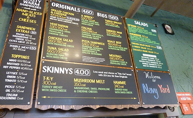
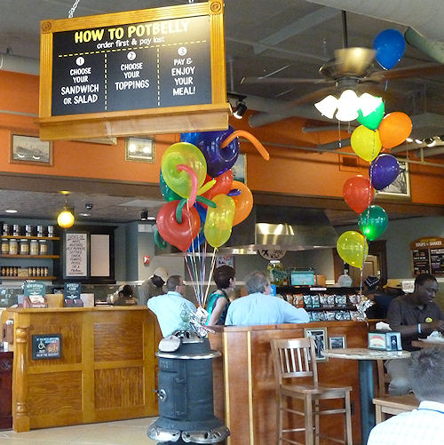
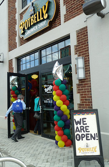
Anything else going on these days? Besides that sandwich shop opening?
UPDATE: Let's add the elephant parade! Starting tonight at 8 pm, on the southern edge of Garfield Park at the train tracks where Virginia crosses under New Jersey, says WTOP.
UPDATE II: And, from the Hill is Home, a Q&A with ANC commissioner David Garber.
UPDATE III: I sent a lackey down to Potbelly to get a few opening-day shots. Hope he's not expecting to get reimbursed for his lunch.
|
Comments (10)
More posts:
55 M St., Pedestrian/Cycling Issues, Fairgrounds/Bullpen, Capper, Capitol Quarter, Trash Transfer Site/DPW, Monument Valley/Half St., Potbelly, Nationals Park
|
As announced by David Garber over the past few days, the neighborhood's third Capital Bikeshare station was installed yesterday, on the northwest corner of 1st and K, SE. It has 15 docks, and is now the closest station for residents of the neighborhood's large residential buildings. It's also three blocks north of Nationals Park, for people concerned gameday dockblocks at 1st and N.
I've added its status data to my Live Transit Page, where in one shot you can get neighborhood and nearby Bikeshare capacity information, Navy Yard Metro Next Train status, Circulator "Where's My Bus?" information for the Navy Yard-Union Station route, and WMATA Next Bus times for the P2 and V7 buses.
Plans have been announced for one more neighborhood dock, at 3rd and Tingey, SE, but there's been no news on when that one might arrive.
Can't wait to include this in my Near Southeast Bikeshare Usage map when the next dataset gets released sometime in spring.
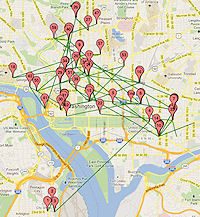 This is little more than an off-topic I-want-to-try-it exercise, but after reading JD Antos's latest crunching of the Capital Bikeshare trip data that came out last week, I decided to see what it would be like to map the movements of a particular bike.
 I picked bike W01000, for no reason other than I saw it while I was browsing through the tables and thought it looked like a nice round number--I make no statements as to how representative it is of other bikes, except that it was in the system for all of 2011, except for a few brief periods when it either didn't hit the rider lottery or was out for maintenance. (And I ignored trips less than a minute long.)
So, want to know where Bike W01000 went on December 1, 2011? Or July 4? Or my birthday? Or any day of your choosing? Take a look and see. Of course, the green lines for "trips" are just as-the-crow flies, and are not the actual routes taken by riders (since the bikes don't have GPS transponders THAT WE KNOW OF!!!).
There's also a table below the map that shows the trips broken out in order for that day, which is handy on days with a number of trips where sometimes the push pins on the map get piled up on each other. Also, note that some trip lines end without a push pin--that's because the pins mark the start of trips, and so if a bike got re-balanced to another station, that ride's endpoint will be pin-less.
You can also browse by month, but it's pretty spaghetti like.
This is quick-and-dirty, so there are probably bugs.
|
Comments (1)
More posts:
Pedestrian/Cycling Issues
|
 When word gets out that some new data set has been posted in an easily digestible format, I am pretty much helpless before its power. So I spent the Friday night of a holiday weekend knee deep in Bikeshare Trip History Data, culling out the
 You'll choose whether you want to see inbound or outbound data for the dock at New Jersey and M in front of the US Department of Transportation or the dock at 1st and N just across the street from Nationals Park. Optionally, you can filter by month of the year or even a specific date. (Tip: green means starting point, red means ending point.) Then there are tables beneath the map that show, for your chosen data set, the number of registered vs. casual users and the top usage days.
It shouldn't be surprising that the docks at the Eastern Market Metro Station and at 4th and M SW (Safeway) are very popular destinations/starting points for the Near Southeast docks, but I'm surprised to be surprised that the top dock for New Jersey & M trips in both directions is Union Station.
Capital Bikeshare is apparently going to release this data quarterly, so I plan to keep the map/search app updated as long as there's data coming. And there should be a new dock in the neighborhood sometime in 2012, at 3rd and Tingey.
PS: Speaking of Bikeshare, read this fascinating piece on one man's transformation into a bicycling commuter thanks to Capital Bikeshare being a "gateway drug." (Any full disclosure I need to make about this link should be pretty clear in the second and fourth paragraphs.)
UPDATE: After reading this great post by JD Antos with scads of analysis of the city-wide Bikeshare trip data, I dug into my tables a little more closely to clear out "rides" of less than 60 seconds' duration at a single station and found that I had inadvertently doubled the records where the both start and stop stations were the two Near Southeast stations. (Argh.) Not a huge change in the data (about 1,250 records out of nearly 30,000), and most likely the data people would have been looking at today would have been for the trips outside of the neighborhood, but I have now cleaned out that boo-boo. And I've deleted 167 sub-60-second trips at a single station as well, just because.
UPDATE II: I added both Union Station and the new dock just north of the freeway at 3rd and G to my Live Transit Data page, which includes a table of the closest docks and their capacity status, along with other live data like Next Train, Next Bus, and Where's My (Circulator) Bus?
|
Comments (4)
More posts:
Pedestrian/Cycling Issues, JDLand stuff
|
 The meeting probably isn't even finished yet, but if you didn't (or did) stop by the first of DDOT's public meetings on their nine-month M Street SE/SW Transportation study, you can browse the presentation slides and take the stakeholder survey, already posted on the new web site for the project.
There were a pile of high-powered bloggers and transportation geeks in attendance, so I'm sure there will no shortage of coverage of both this meeting and the entire study that I will happily link to, but there wasn't much news coming out of this first session--it was mainly to introduce the study, talk about the methodology (which you can see in the slides) and then break up into small groups to stand around maps and give feedback about what attendees see as issues that need addressing. (But first, just as at the 2010 meeting, one woman who is particularly anti-bike once again made her feelings known.)
DDOT's representatives say they will be using some 33 other studies that have been done on the area in question as part of this overall study, covering the area from 14th St. SW to 12th Street SE south of the freeway down to the waterfront(s), though that then brought a comment from the audience about when studying is going to stop and there's going to be action.
There will be two more public meetings, one in March-ish and another in June-ish, with the study expected to be completed in August-ish.
UPDATE: Here's DCist's report on the meeting. And SWill's.
|
Comments (2)
|
Just a reminder that Thursday night (Jan. 12) is the first public meeting for DDOT's M Street SE/SW Transportation Study, from 6:30 pm to 8:30 pm at Westminster Presbyterian Church at 400 I St., SW.
As the meeting announcement says, "The purpose of the public meeting is to provide an overview of the transportation study, outline the study process/schedule and gather public feedback. Following a brief presentation, attendees will be asked to help identify concerns and issues on maps of the study area and also via a brief survey."
It isn't just about the six lanes on M Street, either: the study area goes from the Southeast/Southwest Freeway south to the Anacostia River and Washington Channel, from 12th Street SE all the way to 14th Street SW.
So, if you think there should be fewer lanes, more lanes, less parking, more parking, more bike lanes, fewer bike lanes, more pedestrian-friendly changes, fewer pedestrian-friendly changes, or just like watching people with wildly divergent views all trying to get their position to be the "right" one, come on down.
(You can also read my post on the last M Street traffic meeting, back in 2010, though note it was not part of this current official nine-month study by DDOT.)
|
Comments (0)
|
ANC 6D has sent around (and posted! yay!) the agenda for its January meeting, scheduled for Monday, Jan. 9 at 7 pm at 1100 4th St., SW in DCRA's second-floor meeting room.
The Near Southeast items of interest could mostly be looked at as sneak previews, or perhaps as items that could be missed if you are better able to fit other upcoming meetings into your calendar (especially, if, say, you were looking for an escape hatch because you'd kinda rather be watching the BCS championship):
* There's a M Street SE/SW Transportation Study agenda item, in advance of the DDOT public meeting on the study coming three days later, on Jan. 12;
* There's an update on Capitol Riverfront BID doings, in advance of the BID's annual meeting three days later, on Jan. 12; and
* There's the application for historic landmark status for the DC Water main pumping station, which will be heard by the Historic Preservation Review Board at its January 26 meeting.
There's also an update on the ANC 6D redistricting outcome, various Southwest-related items (including the big Maryland Avenue SW Draft Plan, and whatnot. And, since it's the first meeting of the new year, there will also be the election of commission officers.
|
Comments (8)
More posts:
ANC News, Capitol Riverfront BID, Pedestrian/Cycling Issues, meetings, M Street, preservation, Traffic Issues, DC Water (WASA)
|
Just sent out by DDOT:
"The District Department of Transportation (DDOT) will hold the first in a series of public information meetings for the M Street SE/SW Transportation Study from 6:30 to 8 p.m. on Thursday, January 12, 2012 at the Westminster Presbyterian Church, 400 I Street SW.
"The nine-month study, being conducted as part of the larger Anacostia Waterfront Initiative, seeks to identify current and future transportation issues and possible mitigation strategies along the M Street SE/SW Corridor and Southwest/Southeast Waterfront areas from 12th Street SE west to 14th Street SW and from the Southwest/Southeast Freeway south to the Anacostia River/Washington Channel.
"The purpose of the public meeting is to provide an overview of the transportation study, outline the study process/schedule and gather public feedback."
UPDATE: Here's the DDOT meeting announcement.
|
Comments (6)
|