
|
| |||||||||||||||||||

|
Please note that JDLand is no longer being updated.
peek >>
Near Southeast DC Past News Items: Pedestrian/Cycling Issues
- Full Neighborhood Development MapThere's a lot more than just the projects listed here. See the complete map of completed, underway, and proposed projects all across the neighborhood.
- What's New This YearA quick look at what's arrived or been announced since the end of the 2018 baseball season.
- Food Options, Now and Coming SoonThere's now plenty of food options in the neighborhood. Click to see what's here, and what's coming.
![-]()
- Anacostia RiverwalkA bridge between Teague and Yards Parks is part of the planned 20-mile Anacostia Riverwalk multi-use trail along the east and west banks of the Anacostia River.
![-]()
- Virginia Ave. Tunnel ExpansionConstruction underway in 2015 to expand the 106-year-old tunnel to allow for a second track and double-height cars. Expected completion 2018.
![-]()
- Rail and Bus Times
Get real time data for the Navy Yard subway, Circulator, Bikeshare, and bus lines, plus additional transit information. - Rail and Bus Times
Get real time data for the Navy Yard subway, Circulator, Bikeshare, and bus lines, plus additional transit information. - Canal ParkThree-block park on the site of the old Washington Canal. Construction begun in spring 2011, opened Nov. 16, 2012.
![-]()
- Nationals Park21-acre site, 41,000-seat ballpark, construction begun May 2006, Opening Day March 30, 2008.
![-]()
- Washington Navy YardHeadquarters of the Naval District Washington, established in 1799.
![-]()
- Yards Park5.5-acre park on the banks of the Anacostia. First phase completed September 2010.
![-]()
- Van Ness Elementary SchoolDC Public School, closed in 2006, but reopening in stages beginning in 2015.
![-]()
- Agora/Whole Foods336-unit apartment building at 800 New Jersey Ave., SE. Construction begun June 2014, move-ins underway early 2018. Whole Foods expected to open in late 2018.
![-]()
- New Douglass BridgeConstruction underway in early 2018 on the replacement for the current South Capitol Street Bridge. Completion expected in 2021.
![-]()
- 1221 Van290-unit residential building with 26,000 sf retail. Underway late 2015, completed early 2018.

- NAB HQ/AvidianNew headquarters for National Association of Broadcasters, along with a 163-unit condo building. Construction underway early 2017.

- Yards/Parcel O Residential ProjectsThe Bower, a 138-unit condo building by PN Hoffman, and The Guild, a 190-unit rental building by Forest City on the southeast corner of 4th and Tingey. Underway fall 2016, delivery 2018.

- New DC Water HQA wrap-around six-story addition to the existing O Street Pumping Station. Construction underway in 2016, with completion in 2018.

- The Harlow/Square 769N AptsMixed-income rental building with 176 units, including 36 public housing units. Underway early 2017, delivery 2019.

- West Half Residential420-unit project with 65,000 sf retail. Construction underway spring 2017.
![-]()
- Novel South Capitol/2 I St.530ish-unit apartment building in two phases, on old McDonald's site. Construction underway early 2017, completed summer 2019.
![Novel South Capitol]()
- 1250 Half/Envy310 rental units at 1250, 123 condos at Envy, 60,000 square feet of retail. Underway spring 2017.
![-]()
- Parc Riverside Phase II314ish-unit residential building at 1010 Half St., SE, by Toll Bros. Construction underway summer 2017.
![-]()
- 99 M StreetA 224,000-square-foot office building by Skanska for the corner of 1st and M. Underway fall 2015, substantially complete summer 2018. Circa and an unnamed sibling restaurant announced tenants.
![-]()
- The Garrett375-unit rental building at 2nd and I with 13,000 sq ft retail. Construction underway late fall 2017.
![-]()
- Yards/The Estate Apts. and Thompson Hotel270-unit rental building and 227-room Thompson Hotel, with 20,000 sq ft retail total. Construction underway fall 2017.
![-]()
- Meridian on First275-unit residential building, by Paradigm. Construction underway early 2018.
![-]()
- The Maren/71 Potomac264-unit residential building with 12,500 sq ft retail, underway spring 2018. Phase 2 of RiverFront on the Anacostia development.
![-]()
- DC Crossing/Square 696Block bought in 2016 by Tishman Speyer, with plans for 800 apartment units and 44,000 square feet of retail in two phases. Digging underway April 2018.
![DC Crossing]()
- One Hill South Phase 2300ish-unit unnamed sibling building at South Capitol and I. Work underway summer 2018.
![One Hill South Phase 2]()
- New DDOT HQ/250 MNew headquarters for the District Department of Transportation. Underway early 2019.
![New DDOT HQ]()
- 37 L Street Condos11-story, 74-unit condo building west of Half St. Underway early 2019.
![37 L Condos]()
- CSX East Residential/Hotel225ish-unit AC Marriott and two residential buildings planned. Digging underway late summer 2019.
![CSX East Residential/Hotel]()
- 1000 South Capitol Residential224-unit apartment building by Lerner. Underway fall 2019.
![1000 South Capitol Residential]()
- Capper Seniors 2.0Reconstruction of the 160-unit building for low-income seniors that was destroyed by fire in 2018.
![1000 South Capitol Residential]()
- Chemonics HQNew 285,000-sq-ft office building with 14,000 sq ft of retail. Expected delivery 2021.
![1000 South Capitol Residential]()


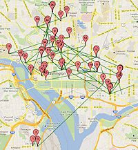 This is little more than an off-topic I-want-to-try-it exercise, but after reading JD Antos's latest crunching of the Capital Bikeshare trip data that came out last week, I decided to see what it would be like to map the movements of a particular bike.
 I picked bike W01000, for no reason other than I saw it while I was browsing through the tables and thought it looked like a nice round number--I make no statements as to how representative it is of other bikes, except that it was in the system for all of 2011, except for a few brief periods when it either didn't hit the rider lottery or was out for maintenance. (And I ignored trips less than a minute long.)
So, want to know where Bike W01000 went on December 1, 2011? Or July 4? Or my birthday? Or any day of your choosing? Take a look and see. Of course, the green lines for "trips" are just as-the-crow flies, and are not the actual routes taken by riders (since the bikes don't have GPS transponders THAT WE KNOW OF!!!).
There's also a table below the map that shows the trips broken out in order for that day, which is handy on days with a number of trips where sometimes the push pins on the map get piled up on each other. Also, note that some trip lines end without a push pin--that's because the pins mark the start of trips, and so if a bike got re-balanced to another station, that ride's endpoint will be pin-less.
You can also browse by month, but it's pretty spaghetti like.
This is quick-and-dirty, so there are probably bugs.
|
Comments (1)
More posts:
Pedestrian/Cycling Issues
|
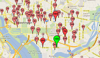 When word gets out that some new data set has been posted in an easily digestible format, I am pretty much helpless before its power. So I spent the Friday night of a holiday weekend knee deep in Bikeshare Trip History Data, culling out the
 You'll choose whether you want to see inbound or outbound data for the dock at New Jersey and M in front of the US Department of Transportation or the dock at 1st and N just across the street from Nationals Park. Optionally, you can filter by month of the year or even a specific date. (Tip: green means starting point, red means ending point.) Then there are tables beneath the map that show, for your chosen data set, the number of registered vs. casual users and the top usage days.
It shouldn't be surprising that the docks at the Eastern Market Metro Station and at 4th and M SW (Safeway) are very popular destinations/starting points for the Near Southeast docks, but I'm surprised to be surprised that the top dock for New Jersey & M trips in both directions is Union Station.
Capital Bikeshare is apparently going to release this data quarterly, so I plan to keep the map/search app updated as long as there's data coming. And there should be a new dock in the neighborhood sometime in 2012, at 3rd and Tingey.
PS: Speaking of Bikeshare, read this fascinating piece on one man's transformation into a bicycling commuter thanks to Capital Bikeshare being a "gateway drug." (Any full disclosure I need to make about this link should be pretty clear in the second and fourth paragraphs.)
UPDATE: After reading this great post by JD Antos with scads of analysis of the city-wide Bikeshare trip data, I dug into my tables a little more closely to clear out "rides" of less than 60 seconds' duration at a single station and found that I had inadvertently doubled the records where the both start and stop stations were the two Near Southeast stations. (Argh.) Not a huge change in the data (about 1,250 records out of nearly 30,000), and most likely the data people would have been looking at today would have been for the trips outside of the neighborhood, but I have now cleaned out that boo-boo. And I've deleted 167 sub-60-second trips at a single station as well, just because.
UPDATE II: I added both Union Station and the new dock just north of the freeway at 3rd and G to my Live Transit Data page, which includes a table of the closest docks and their capacity status, along with other live data like Next Train, Next Bus, and Where's My (Circulator) Bus?
|
Comments (4)
More posts:
Pedestrian/Cycling Issues, JDLand stuff
|
 The meeting probably isn't even finished yet, but if you didn't (or did) stop by the first of DDOT's public meetings on their nine-month M Street SE/SW Transportation study, you can browse the presentation slides and take the stakeholder survey, already posted on the new web site for the project.
There were a pile of high-powered bloggers and transportation geeks in attendance, so I'm sure there will no shortage of coverage of both this meeting and the entire study that I will happily link to, but there wasn't much news coming out of this first session--it was mainly to introduce the study, talk about the methodology (which you can see in the slides) and then break up into small groups to stand around maps and give feedback about what attendees see as issues that need addressing. (But first, just as at the 2010 meeting, one woman who is particularly anti-bike once again made her feelings known.)
DDOT's representatives say they will be using some 33 other studies that have been done on the area in question as part of this overall study, covering the area from 14th St. SW to 12th Street SE south of the freeway down to the waterfront(s), though that then brought a comment from the audience about when studying is going to stop and there's going to be action.
There will be two more public meetings, one in March-ish and another in June-ish, with the study expected to be completed in August-ish.
UPDATE: Here's DCist's report on the meeting. And SWill's.
|
Comments (2)
|
Just a reminder that Thursday night (Jan. 12) is the first public meeting for DDOT's M Street SE/SW Transportation Study, from 6:30 pm to 8:30 pm at Westminster Presbyterian Church at 400 I St., SW.
As the meeting announcement says, "The purpose of the public meeting is to provide an overview of the transportation study, outline the study process/schedule and gather public feedback. Following a brief presentation, attendees will be asked to help identify concerns and issues on maps of the study area and also via a brief survey."
It isn't just about the six lanes on M Street, either: the study area goes from the Southeast/Southwest Freeway south to the Anacostia River and Washington Channel, from 12th Street SE all the way to 14th Street SW.
So, if you think there should be fewer lanes, more lanes, less parking, more parking, more bike lanes, fewer bike lanes, more pedestrian-friendly changes, fewer pedestrian-friendly changes, or just like watching people with wildly divergent views all trying to get their position to be the "right" one, come on down.
(You can also read my post on the last M Street traffic meeting, back in 2010, though note it was not part of this current official nine-month study by DDOT.)
|
Comments (0)
|
ANC 6D has sent around (and posted! yay!) the agenda for its January meeting, scheduled for Monday, Jan. 9 at 7 pm at 1100 4th St., SW in DCRA's second-floor meeting room.
The Near Southeast items of interest could mostly be looked at as sneak previews, or perhaps as items that could be missed if you are better able to fit other upcoming meetings into your calendar (especially, if, say, you were looking for an escape hatch because you'd kinda rather be watching the BCS championship):
* There's a M Street SE/SW Transportation Study agenda item, in advance of the DDOT public meeting on the study coming three days later, on Jan. 12;
* There's an update on Capitol Riverfront BID doings, in advance of the BID's annual meeting three days later, on Jan. 12; and
* There's the application for historic landmark status for the DC Water main pumping station, which will be heard by the Historic Preservation Review Board at its January 26 meeting.
There's also an update on the ANC 6D redistricting outcome, various Southwest-related items (including the big Maryland Avenue SW Draft Plan, and whatnot. And, since it's the first meeting of the new year, there will also be the election of commission officers.
|
Comments (8)
More posts:
ANC News, Capitol Riverfront BID, Pedestrian/Cycling Issues, meetings, M Street, preservation, Traffic Issues, DC Water (WASA)
|
Just sent out by DDOT:
"The District Department of Transportation (DDOT) will hold the first in a series of public information meetings for the M Street SE/SW Transportation Study from 6:30 to 8 p.m. on Thursday, January 12, 2012 at the Westminster Presbyterian Church, 400 I Street SW.
"The nine-month study, being conducted as part of the larger Anacostia Waterfront Initiative, seeks to identify current and future transportation issues and possible mitigation strategies along the M Street SE/SW Corridor and Southwest/Southeast Waterfront areas from 12th Street SE west to 14th Street SW and from the Southwest/Southeast Freeway south to the Anacostia River/Washington Channel.
"The purpose of the public meeting is to provide an overview of the transportation study, outline the study process/schedule and gather public feedback."
UPDATE: Here's the DDOT meeting announcement.
|
Comments (6)
|
* There was a "Wait, what?" moment on Tuesday when DCist reported that a velodrome would be coming in 2012 "in the shadow of Nationals Park in Southeast DC." I did some quick sleuthing, looking at the organization's web site and seeing Akridge as a partner, but I just couldn't place the design as being along Half Street. Then, thinking about how people so often can't get Southeast and Southwest straight when it comes to anything near the ballpark, I took a look at the Google Maps view of Akridge's Buzzard Point land at 1st and V SW, and Ta-Da! A pretty clear match.
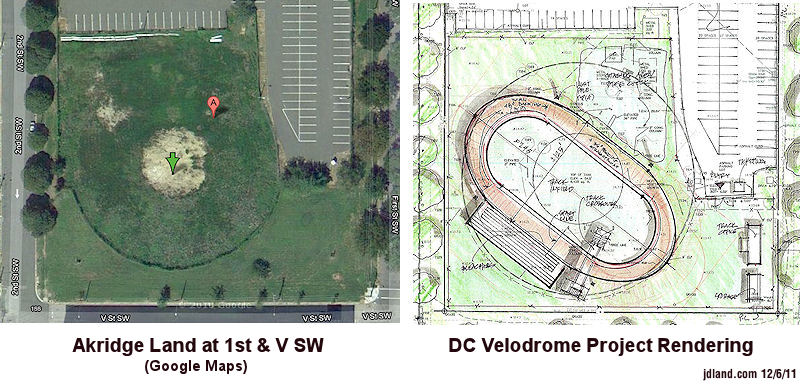
But this morning, Akridge is no longer listed as a partner on the web site, and the site rendering is gone, too. Perhaps this is all just because final leases and paperwork hadn't quite yet been signed. (A not uncommon tale, young upstarts getting all excited about a pending deal and blabbing just a little too much info for the comfort of the big company they're dealing with. Though it doesn't necessarily mean the deal is dead.) Of course, this is all actually outside my territory, so you'll want to go to SWill for updates.
UPDATE: Jonathan O'Connell has tweeted this out: "Akridge spokeswoman on velodrome: 'We don't have an agreement.' And: 'I would say that putting Akridge on the site was probably premature'."
* Last Wednesday, DDOT installed the new Bikeshare station at 3rd & G, SE, on the north side of the Results parking lot. This is technically outside of Near Southeast, but it's probably now the closest station for Capitol Quarter folks (and me!). It has 19 docks.
* DDOT is shooting for the weekend of Dec. 16 to open the new inbound/outbound freeway spans of the 11th Street Bridges, and they tormented me with some helicopter shots of the current progress. (Though remember that it's just the spans opening--they still have work to do on the ramps and flyovers to add the new movements to and from DC-295.) They also tweeted that the 11th Street Local bridge is ahead of schedule and will open spring/summer of next year. My construction progress photos from Nov. 1 are a smidge out of date by now, but still worth looking at.
* Foundry Lofts now has 19 moved-in residents.
(Of course, you already know much of this if you follow me on Twitter or Facebook.)
|
Comments (6)
More posts:
11th Street Bridges, West Half St., Pedestrian/Cycling Issues, Foundry Lofts/Yards, Nationals Park, The Yards
|
 The word is going out that the official dedication of the new pedestrian bridge connecting the Yards Park and Diamond Teague Park will be held on Tuesday, Nov. 22, at 1:30 pm. The mayor is expected to be there, along with George Hawkins of DC Water (since the bridge runs right past the main pumping station) and I'm sure a slew of other dignitaries.
This is the bridge that will allow for an easier and more enjoyable stroll between the Yards Park and Nationals Park, depositing stadium-goers right across the street from the Grand Staircase/1st Base Gate at 1st Street and Potomac Avenue. And it will also allow water taxi customers disembarking at Teague Piers to get to the Yards Park without having to hike up to Tingey Street and then over a few blocks. (Eventually the Yards Park will have its own marina and water taxi piers, but not for another few years.)
It is part of the Anacostia Riverwalk Trail, and eventually will also connect to a larger public plaza adjacent to Teague Park, as part of the easternmost development of the FloridaRock/RiverFront project.
Hope they have good weather for the ribbon cutting!
(This is probably also a good time to make quick mention of AtlanticCities' recent naming of the Yards Park as one of America's Best New Parks.)
|
Comments (1)
|
 * On October 3, the following changes will be made to the Navy Yard-Union Station Circulator route: "[B]uses will no longer travel west on Constitution Avenue and north on Louisiana Avenue to reach Union Station. Buses will instead stop adjacent to Union Station on Columbus Circle at the flag poles before turning right on F Street, NE and right on 2nd Street, NE to Constitution Avenue. The route will no longer serve the Union Station garage level and the stops located at Louisiana and D Streets, NE will no longer be served." Other Circulator changes--including the end of the SW-Convention Center route and the beginning of an east-of-the-river route that will run down Barracks Row--are listed here.
* DDOT and the Washington Area Bicyclist Association (WABA), along with ANC commissioner David Garber, have launched "Rack Attack," which will result in the installation of 36 new bike racks around Near Southeast. The first one was installed this morning at Cornercopia.
|
Comments (3)
More posts:
Pedestrian/Cycling Issues, circulator
|
It's been so long since I've written about this that I forgot it was even still in progress, but DDOT has announced two public meetings to present the "preferred alternative" and the Final Environmental Impact Statement for the South Capitol Street Corridor, first on April 26 at Amidon-Bowen Elementary School in SW and then two days later at Savoy Elementary School in SE. This is the long-term study of how to improve South Capitol Street on both sides of the Anacostia River to better address safety, traffic, pedestrian, and streetscape issues, and includes the construction of a new Frederick Douglass Bridge.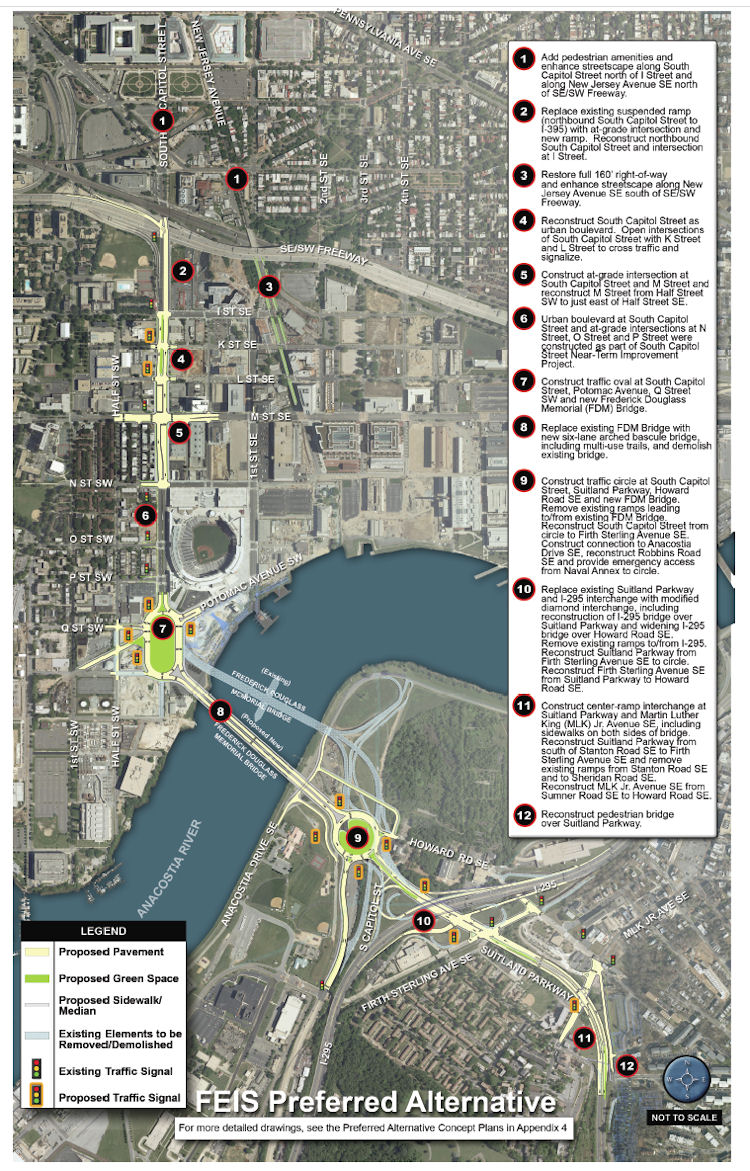 * Add "pedestrian amenities" and enhance the streetcape along South Capitol north of I and along New Jersey Avenue SE north of the freeway.
If you are interested in this subject, there is more verbiage and documentation accompanying the plans than you could ever dream of. (Traffic studies! Environmental consequences! Technical reports!) And I've written a lot about the process, which began more than a decade ago with other studies before the EIS got underway. And I'm sure there will be posts on other blogs delving more specifically into portions of the plans. But, since most people probably want to know "what does this mean for me?", you can see this graphic (from the 224-MB chapter 2 of the FEIS) giving a quick overview of what changes are planned along South Capitol Street if the final EIS is signed off on (and, more importantly, if funding is secured). The short version, for the west side of the Anacostia:
* Add "pedestrian amenities" and enhance the streetcape along South Capitol north of I and along New Jersey Avenue SE north of the freeway.* Replace the existing ramp to the freeway from South Capitol and I with an at-grade intersection. (This would be a left turn onto a ramp to the freeway from under the freeway, near the current Nats HH economy parking lot.)
* Bring New Jersey Avenue SE back to a 160-foot full right-of-way, and add streetscape enhancements.
* "Reconstruct South Capitol Street as an urban boulevard." This means bringing M Street up to an "at-grade" intersection (no more tunnel), and would include new signalized at-grade intersections to allow traffic to cross South Capitol on K and L streets. (M Street would also get reconstructed between the Halfs [SE and SW].) The section of South Capitol north of M would have the same streetscape that the south portion received during its 2007/08 makeover, with wide sidewalks and a tree-lined median.
* Build a traffic oval at South Capitol, Potomac, Q, as the gateway to a new arched bascule-design Douglass Bridge that would have wide "multi-use trails" (i.e., sidewalks!) in both directions. The existing bridge would be demolished, after the new bridge is built somewhat downriver of the current location.
The Executive Summary (220 MB PDF) gives a good overview of the FEIS and preferred alternative (as it should!), but I also suggest wandering through the Chapter 2: Alternatives section, especially if you came to the neighborhood or JDLand after 2008 and didn't get to follow along during the EIS process, or if you're interested in the additional plans for east of the river, which I'm going to leave to others to discuss. My previous posts on all of this may be of interest as well. If you're wanting to see some of the earlier studies referenced in the FEIS, there are links to them at the top of my South Capitol Street project page.
How much would this all cost? The preferred alternative is priced in this final EIS at $806 million (not billion! yeesh) in FY 2014 dollars. (New bridges are expensive, you know.)
(I know that this is a very quick overview of a big study and plan, but there will be plenty of time to talk more about it, especially with the upcoming public meetings.)
|
Comments (1)
|