
|
| |||||||||||||||||||

|
Please note that JDLand is no longer being updated.
peek >>
Near Southeast DC Past News Items: Pedestrian/Cycling Issues
- Full Neighborhood Development MapThere's a lot more than just the projects listed here. See the complete map of completed, underway, and proposed projects all across the neighborhood.
- What's New This YearA quick look at what's arrived or been announced since the end of the 2018 baseball season.
- Food Options, Now and Coming SoonThere's now plenty of food options in the neighborhood. Click to see what's here, and what's coming.
![-]()
- Anacostia RiverwalkA bridge between Teague and Yards Parks is part of the planned 20-mile Anacostia Riverwalk multi-use trail along the east and west banks of the Anacostia River.
![-]()
- Virginia Ave. Tunnel ExpansionConstruction underway in 2015 to expand the 106-year-old tunnel to allow for a second track and double-height cars. Expected completion 2018.
![-]()
- Rail and Bus Times
Get real time data for the Navy Yard subway, Circulator, Bikeshare, and bus lines, plus additional transit information. - Rail and Bus Times
Get real time data for the Navy Yard subway, Circulator, Bikeshare, and bus lines, plus additional transit information. - Canal ParkThree-block park on the site of the old Washington Canal. Construction begun in spring 2011, opened Nov. 16, 2012.
![-]()
- Nationals Park21-acre site, 41,000-seat ballpark, construction begun May 2006, Opening Day March 30, 2008.
![-]()
- Washington Navy YardHeadquarters of the Naval District Washington, established in 1799.
![-]()
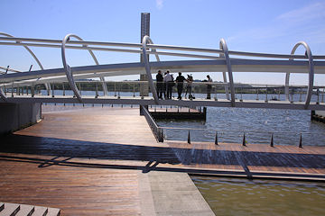
- Yards Park5.5-acre park on the banks of the Anacostia. First phase completed September 2010.
![-]()
- Van Ness Elementary SchoolDC Public School, closed in 2006, but reopening in stages beginning in 2015.
![-]()
- Agora/Whole Foods336-unit apartment building at 800 New Jersey Ave., SE. Construction begun June 2014, move-ins underway early 2018. Whole Foods expected to open in late 2018.
![-]()
- New Douglass BridgeConstruction underway in early 2018 on the replacement for the current South Capitol Street Bridge. Completion expected in 2021.
![-]()
- 1221 Van290-unit residential building with 26,000 sf retail. Underway late 2015, completed early 2018.

- NAB HQ/AvidianNew headquarters for National Association of Broadcasters, along with a 163-unit condo building. Construction underway early 2017.

- Yards/Parcel O Residential ProjectsThe Bower, a 138-unit condo building by PN Hoffman, and The Guild, a 190-unit rental building by Forest City on the southeast corner of 4th and Tingey. Underway fall 2016, delivery 2018.

- New DC Water HQA wrap-around six-story addition to the existing O Street Pumping Station. Construction underway in 2016, with completion in 2018.

- The Harlow/Square 769N AptsMixed-income rental building with 176 units, including 36 public housing units. Underway early 2017, delivery 2019.

- West Half Residential420-unit project with 65,000 sf retail. Construction underway spring 2017.
![-]()
- Novel South Capitol/2 I St.530ish-unit apartment building in two phases, on old McDonald's site. Construction underway early 2017, completed summer 2019.
![Novel South Capitol]()
- 1250 Half/Envy310 rental units at 1250, 123 condos at Envy, 60,000 square feet of retail. Underway spring 2017.
![-]()
- Parc Riverside Phase II314ish-unit residential building at 1010 Half St., SE, by Toll Bros. Construction underway summer 2017.
![-]()
- 99 M StreetA 224,000-square-foot office building by Skanska for the corner of 1st and M. Underway fall 2015, substantially complete summer 2018. Circa and an unnamed sibling restaurant announced tenants.
![-]()
- The Garrett375-unit rental building at 2nd and I with 13,000 sq ft retail. Construction underway late fall 2017.
![-]()
- Yards/The Estate Apts. and Thompson Hotel270-unit rental building and 227-room Thompson Hotel, with 20,000 sq ft retail total. Construction underway fall 2017.
![-]()
- Meridian on First275-unit residential building, by Paradigm. Construction underway early 2018.
![-]()
- The Maren/71 Potomac264-unit residential building with 12,500 sq ft retail, underway spring 2018. Phase 2 of RiverFront on the Anacostia development.
![-]()
- DC Crossing/Square 696Block bought in 2016 by Tishman Speyer, with plans for 800 apartment units and 44,000 square feet of retail in two phases. Digging underway April 2018.
![DC Crossing]()
- One Hill South Phase 2300ish-unit unnamed sibling building at South Capitol and I. Work underway summer 2018.
![One Hill South Phase 2]()
- New DDOT HQ/250 MNew headquarters for the District Department of Transportation. Underway early 2019.
![New DDOT HQ]()
- 37 L Street Condos11-story, 74-unit condo building west of Half St. Underway early 2019.
![37 L Condos]()
- CSX East Residential/Hotel225ish-unit AC Marriott and two residential buildings planned. Digging underway late summer 2019.
![CSX East Residential/Hotel]()
- 1000 South Capitol Residential224-unit apartment building by Lerner. Underway fall 2019.
![1000 South Capitol Residential]()
- Capper Seniors 2.0Reconstruction of the 160-unit building for low-income seniors that was destroyed by fire in 2018.
![1000 South Capitol Residential]()
- Chemonics HQNew 285,000-sq-ft office building with 14,000 sq ft of retail. Expected delivery 2021.
![1000 South Capitol Residential]()


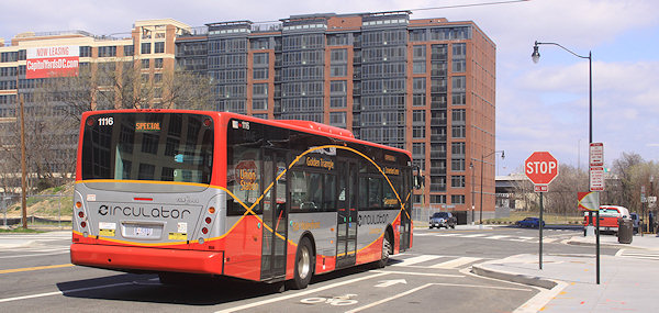 * On October 3, the following changes will be made to the Navy Yard-Union Station Circulator route: "[B]uses will no longer travel west on Constitution Avenue and north on Louisiana Avenue to reach Union Station. Buses will instead stop adjacent to Union Station on Columbus Circle at the flag poles before turning right on F Street, NE and right on 2nd Street, NE to Constitution Avenue. The route will no longer serve the Union Station garage level and the stops located at Louisiana and D Streets, NE will no longer be served." Other Circulator changes--including the end of the SW-Convention Center route and the beginning of an east-of-the-river route that will run down Barracks Row--are listed here.
* DDOT and the Washington Area Bicyclist Association (WABA), along with ANC commissioner David Garber, have launched "Rack Attack," which will result in the installation of 36 new bike racks around Near Southeast. The first one was installed this morning at Cornercopia.
|
Comments (3)
More posts:
Pedestrian/Cycling Issues, circulator
|
It's been so long since I've written about this that I forgot it was even still in progress, but DDOT has announced two public meetings to present the "preferred alternative" and the Final Environmental Impact Statement for the South Capitol Street Corridor, first on April 26 at Amidon-Bowen Elementary School in SW and then two days later at Savoy Elementary School in SE. This is the long-term study of how to improve South Capitol Street on both sides of the Anacostia River to better address safety, traffic, pedestrian, and streetscape issues, and includes the construction of a new Frederick Douglass Bridge.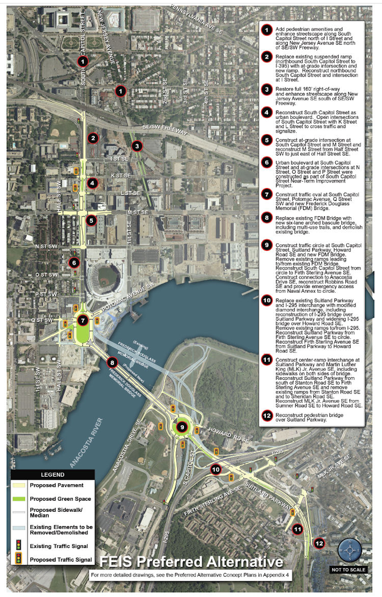 * Add "pedestrian amenities" and enhance the streetcape along South Capitol north of I and along New Jersey Avenue SE north of the freeway.
If you are interested in this subject, there is more verbiage and documentation accompanying the plans than you could ever dream of. (Traffic studies! Environmental consequences! Technical reports!) And I've written a lot about the process, which began more than a decade ago with other studies before the EIS got underway. And I'm sure there will be posts on other blogs delving more specifically into portions of the plans. But, since most people probably want to know "what does this mean for me?", you can see this graphic (from the 224-MB chapter 2 of the FEIS) giving a quick overview of what changes are planned along South Capitol Street if the final EIS is signed off on (and, more importantly, if funding is secured). The short version, for the west side of the Anacostia:
* Add "pedestrian amenities" and enhance the streetcape along South Capitol north of I and along New Jersey Avenue SE north of the freeway.* Replace the existing ramp to the freeway from South Capitol and I with an at-grade intersection. (This would be a left turn onto a ramp to the freeway from under the freeway, near the current Nats HH economy parking lot.)
* Bring New Jersey Avenue SE back to a 160-foot full right-of-way, and add streetscape enhancements.
* "Reconstruct South Capitol Street as an urban boulevard." This means bringing M Street up to an "at-grade" intersection (no more tunnel), and would include new signalized at-grade intersections to allow traffic to cross South Capitol on K and L streets. (M Street would also get reconstructed between the Halfs [SE and SW].) The section of South Capitol north of M would have the same streetscape that the south portion received during its 2007/08 makeover, with wide sidewalks and a tree-lined median.
* Build a traffic oval at South Capitol, Potomac, Q, as the gateway to a new arched bascule-design Douglass Bridge that would have wide "multi-use trails" (i.e., sidewalks!) in both directions. The existing bridge would be demolished, after the new bridge is built somewhat downriver of the current location.
The Executive Summary (220 MB PDF) gives a good overview of the FEIS and preferred alternative (as it should!), but I also suggest wandering through the Chapter 2: Alternatives section, especially if you came to the neighborhood or JDLand after 2008 and didn't get to follow along during the EIS process, or if you're interested in the additional plans for east of the river, which I'm going to leave to others to discuss. My previous posts on all of this may be of interest as well. If you're wanting to see some of the earlier studies referenced in the FEIS, there are links to them at the top of my South Capitol Street project page.
How much would this all cost? The preferred alternative is priced in this final EIS at $806 million (not billion! yeesh) in FY 2014 dollars. (New bridges are expensive, you know.)
(I know that this is a very quick overview of a big study and plan, but there will be plenty of time to talk more about it, especially with the upcoming public meetings.)
|
Comments (1)
|
Michael Perkins at GGW got his hands on the draft version DDOT's 2010 Ballpark District Performance Parking Report, and while I'll leave it to him to handle the in-depth discussion of pricing and meter use in Near Southeast as well as other neighborhoods, there are a few action items in the report that might be of general interest (you should read all 31 pages if you want the nitty-gritty).
Now, this is a draft report, but assuming it becomes final...:
Revenues from the parking program have been able to provide $812,100 for "non-automotive transportation improvements" in 2011, which will include a new Capital Bikeshare location at the Yards Park and $135,000 for a new fence along New Jersey Avenue by the railroad tracks (presumably it won't hide the "Water Pylons" public art coming to the freeway underpass). There will also be two or three other new bikeshare stations somewhere in the Ballpark District parking zones (Near Southeast, Southwest, and southern Capitol Hill), but those haven't been announced.
There will also be a $70,000 grant to partially fund a Capitol Riverfront BID Transportation Study, which the page 25 of the report says will happen during this fiscal year and will look at:
* The need for additional traffic signals and stop signs based on pedestrian and vehicular patterns (and recent accidents);
* Neighborhood traffic circulation patterns including one way street circulation and freeway access and turning movements onto the freeway frontage roads;
* How the CSX tunnel reconstruction will impact traffic flow and SE/SW freeway access/egress;
* Existing and future parking demand and the proposed parking supply to meet that demand;
* On street parking strategies and supply for commercial, residential and visitor populations;
* Optimum Circulator routes and hours of operation;
* Recommended routes for bike lanes that tie into the Riverfront Trail system;
* The optimum route for a streetcar line in the M Street right of way and how it would service the Buzzard Point subdistrict; and
* How M Street is designed and works as a multi-modal transit corridor while exhibiting a high quality of design in the public realm.
Gosh, I'm just not sure if residents will be interested in any of these! If perchance a reader or two might have an idea or data point for the above items, feel free to discuss in the comments.
Note that this study doesn't quite seem to match the overarching Near Southeast/Southwest combined traffic study that got some discussion late last year, but perhaps there's more going on than what's mentioned in the DDOT report.
DDOT is also proposing that non-gameday parking rates at the multispace meters between South Capitol and 2nd Streets from the freeway to M Street go up to $6 for three hours (first hour $1.50, second hour $2.50, third hour $3). Plus, the boundaries of the parking zone will move eastward to 11th St. SE from 9th St.
By the way, if you have a fab idea for how some of the proceeds from the parking revenue can be spent on the aforementioned non-automotive transportation improvements, you can submit a written proposal to DDOT (further information on page 26 of the report). And if you want background on how the Performance Parking Pilot came into existence back in 2008, my Stadium Parking page can help with that.
|
Comments (2)
More posts:
Capitol Riverfront BID, Pedestrian/Cycling Issues, New Jersey Ave., parking, Traffic Issues, The Yards, Yards Park
|
City Paper's Housing Complex blog reported late Friday afternoon that DDOT has decided to put in a "Barnes Dance" configuration (also known as a pedestrian scramble) at New Jersey and M, SE, sometime early in 2011. This is the setup where traffic on all sides have a red light at the same time, allowing pedestrians to cross in any direction. The first one in DC was put in at 7th and H in Chinatown a few months ago. With so many people needing to cross diagonally to go between the Navy Yard Metro station entrance and USDOT, this is probably a good choice for another intersection to try it out.
(Though I do dream of a day far in the future, when Forest City builds an office building on the NGA site on the southwest corner of the intersection as part of the Yards, that that new construction would include an additional entrance to the Metro station, obviating the need for people on the south side of M to cross the street to get to the subway.)
|
Comments (0)
More posts:
Pedestrian/Cycling Issues, Traffic Issues
|
Missed this in yesterday's post on this week's events: WalkingTown DC is this weekend, and among the many (many!) walking and biking tours is once again a Capitol Riverfront BID-branded tour, "Capitol Riverfront: From Navy Yard to Front Yard", on Sunday (Sept. 26) from 10 am to 11 am. The tour, lead by BID executive director Michael Stevens, meets at the New Jersey Avenue entrance to the Navy Yard Metro station.
If you're in really (really!) good shape, you can then zip from this tour to the Stadium-Armory Metro station for a Ward 6 biking tour led by Tommy Wells, "Ward 6 Past Meets the Future Bike Tour." It's a 6.5-mile ride from 11 am to 12:30 pm that will start at Kingman Island and hit Eastern Market and Barracks Row before hitting the parks of Near Southeast (Canal, Yards, Teague, and Nationals) and then continuing on into Southwest.
No reservations are required for either tour. (I'd link directly to the entries for each, but the WalkingTown site isn't set up for that. So here's the lists of Sunday morning walking tours and the biking tours. Start scrolling!)
|
Comments (0)
More posts:
Capitol Riverfront BID, Pedestrian/Cycling Issues, Events
|
I'm back from spending the past week wandering around Ohio (Columbus, Cincinnati, Cleveland) and then spending some time in the Detroit area, where my husband grew up and where I lived for a few years as a tyke many years ago. If I was sent back in time 10 years and told to be a city blogger again but that I couldn't do Near Southeast, I would gladly have chosen to document the decay (and perhaps eventual return) of Detroit, because it's really on a scale that is hard for people to understand unless they've spent a lot of time driving all around the city (and not just on the freeways). It also means I would have spent the past 10 years eating plenty of Detroit Pizza at Buddy's and Cloverleaf and having far easier access to a bazillion breakfast options (at the Coneys and other "family dining" establishments) than we'll ever have in the DC Metro area. Plus there's the cider mills.
We also very much enjoyed Columbus, particularly the Short North and German Village neighborhoods (and driving through the Ohio State campus in my University of Florida-festooned car--ha ha!), and my husband also noted the bars and restaurants in the Arena District and asked if that's what will eventually be coming to Half Street. (I then asked him if he ever reads my blog.) Downtown Cincinnati has some great "old stock" storefronts and signage (which we're always big fans of), but we also enjoyed the Kentucky towns of Covington and Newport, right across the river from Cincy's two stadiums. It helped that our hotel was three blocks from the massive Covington Oktoberfest celebration. And yes, we ate chili. Cleveland was mainly a pilgrimmage to the Rock and Roll Hall of Fame for me, but we did wander around to eat in the Tremont and Ohio City neighborhoods, and took a peek at Shaker Heights.
(Are you as worn out from our vacation as I am? We do tend to cover a lot of territory.)
I don't think I deprived you of any big news while I was gone, so, instead, we'll look ahead at a few events this week:
* Today begins the Nats' final homestand of the 2010 season, against the Astros, Braves, and Phillies, with the final home game on Wednesday Sept. 29 at 7:05 pm. And note that this Thursday's game (Sept. 23) against the Astros is a 4:35 pm start, and Saturday's game (Sept. 25) against the Braves is at 1:05 pm. Then you can start looking ahead to the 2011 Nationals schedule, where they get an Opening Day home game on March 31 against the Braves.
* Tomorrow (Tuesday, Sept. 21) is ANC 6B's monthly meeting (delayed a week to avoid coinciding with the election), and the agenda includes CSX's plans for an archaeological dig at Virginia Avenue Park. The meeting is at 7 pm at the People's Church, 535 8th St., SE.
* Thursday is the Washington Area Bicyclist Association's "Moonlight Ride at Yards Park", which includes an 11-mile ride starting from the Park at 8:30 pm heading west to the Potomac River, and a 6-mile ride starting at 9 pm that will go east over the Anacostia River into Anacostia Park and Historic Anacostia. The rides are free and open to the public, but they ask that you register in advance.
* And, looking ahead a bit, the newly redesigned "Parcel D" residential/retail/grocery development on the southeast corner of 4th and M in the Yards will be presented to the National Capital Planning Commission on Oct. 7.
UPDATE: I guess I should also be mentioning the launch of Capital Bikeshare today, with two locations in Near Southeast, at New Jersey and M by USDOT, and what the map says is another station at First and N, SE, by Nationals Park (which I had heard wasn't coming until next spring).
|
Comments (0)
More posts:
ANC News, Pedestrian/Cycling Issues, CSX/Virginia Ave. Tunnel, Events, meetings, Nationals Park, Stadium Events, Virginia Ave Park, The Yards, Twelve12/Teeter/Yards, Yards Park
|
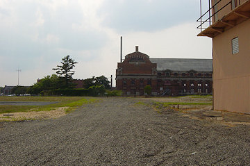
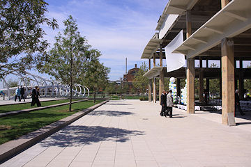
As promised, I've updated my Yards Park page to incorporate some before-and-after photos to highlight the transformation of this patch of land from a bunch of nothingness to a waterfront destination. But I'd also suggest looking through my Expanded Yards Park archive for a more complete set of photos that really show how these five acres have changed since 2005. (And I'll be adding more pairs to the expanded archive this weekend, having missed a few spots in my recent visits.) They really are a pretty striking batch of photos, if I may say so myself....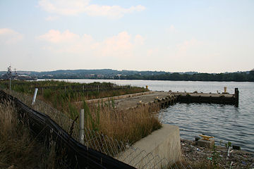
And, in other Yards Park-related news, the Washington Area Bicyclist Association (with the BID and Forest City) is sponsoring a "Moonlight Ride at Yards Park" on Sept. 23, which includes an 11-mile ride starting from the Park at 8:30 pm heading west to the Potomac River, and a 6-mile ride starting at 9 pm that will go east over the Anacostia River into Anacostia Park and Historic Anacostia. The rides are free and open to the public, but they ask that you register in advance so that they know how many people to expect. (There's also discounted tickets available for that afternoon's 4:35 pm game at Nats Park versus the Houston Astros, if you want to watch a game with your fellow cyclists before heading out on the ride.)
|
Comments (0)
|
A few readers have noted to me that, as of last week, no one from ANC 6D07 had turned in any nominating petitions for this year's elections. The Sept. 3 deadline is still a few weeks away, and while he hasn't done his paperwork, current and longtime 6D07 commissioner Bob Siegel has confirmed to me that he will be running again. It will be interesting to see if anyone else from the neighborhood decides to run--especially now that 6D07 has considerably more residents than it had for many years, meaning that the pool of potential candidates is a lot bigger.
If I've kickstarted the community politician in you and you decide you want to run, Frozen Tropics has a nice run-down of how to become a candidate. And the qualifications are pretty simple: you must be a registered voter and have lived in your SMD for 60 days (in other words, having moved into 6D07 no later than July 5, 2010) before submitting your nomination petitions.
I think the more interesting time in 6D07, however, will be in 2012, when the city goes through its once-a-decade realignment of ANC boundaries. Each ANC single-member district (SMD) is supposed to represent about 2,000 residents, which means that 6D07--with a population now up to around 3,500 thanks to the multitude of new apartment buildings north of Nationals Park as well as the Capitol Quarter townhouse development--will very likely be broken up into two districts. And, beyond that--would the Near Southeast SMD(s) remain part of 6D, which otherwise is completely within the boundaries of Southwest, or would one or both new districts possibly end up being moved to ANC 6B, the southern Capitol Hill ANC. (A small part of 6B is already south of the freeway, from Seventh Street over to 11th Street down to M Street.)
In other political news of note for the neighborhood, this Mike Debonis piece in the WashPost on Tommy Wells and his challenger Kelvin Robinson is a good look at the issues swirling in the Ward 6 council seat Democratic primary, particularly whether Wells' focus on "liveable walkable communities" and other new urbanism ideas (like the plastic bag tax) are interesting to Ward 6 constituents who aren't necessarily on the streetcar/multimodal bandwagon. And CP's Housing Complex blog also looks at the story, commenting that "Instead of painting a picture of a rosy future, Wells might be better advised to depict the absence of excellent transit and walkable communities as a current ill that must be rectified, putting those deficiencies on the level of crime as a pressing issue."
The DC primary elections are on Tuesday, Sept. 14. No matter what your leanings are, be sure to vote.
(I haven't written hardly at all on the mayor's race because, well, there's a billion other people doing that.)
|
Comments (0)
|
Hasn't been much swirling around lately worthy of a full blog post, but here are a couple items so that people don't think I've shut down (though most of them have already been seen on my Twitter feed, aka the "I'm Too Lazy to Blog" feed):
* The light tower at the Yards Park is being installed today, about four weeks in advance of the scheduled grand opening on Sept. 10. I hope to have pictures at some point.
* Greater Greater Washington reports that MPD fanned out around Nationals Park on Wednesday night, ticketing drivers and pedestrians and handing out flyers on safety. GGW also brings up the public meeting held by Tommy Wells back in March about the notion of reworking M Street under the "Complete Streets" principles of creating road networks that work for pedestrians young and old, cyclists, public transportation users, and drivers. by doing things such as adding dedicated bike lanes, creating safer crosswalks, etc. At that meeting, residents of Southwest were unimpressed with the possibilities, but the few Southeast residents in attendance seemed more open to it.
UPDATE: TBD reports that the truck driver in last week's incident is not being cited.
* The Post did a video feature on Hoopernatural, the hula hooping fitness outfit. They are running classes for mixed-levels of hoopiness during August at Canal Park, on Saturday mornings from 10 to 11 am.
* The Capitol Riverfront BID is running a survey to get feedback from residents, workers, and visitors on the types of events the BID holds (concerts, outdoor movies, farmers' market, etc.). Let your feelings be known here.
* While my griping about the bad signage on the SW Freeway (highlighted again by the Post on Thursday) is technically out-of-boundaries, it is on topic to also mention to DDOT that the various blue "services" signs for the South Capitol Street exits on I-395 probably need to get rid of the gas station icons, since the days of having three gas stations right on South Capitol and two within a few blocks to the east are long gone. (But @DDOTDC has put me in a time out after Thursday's flurry of transit-related tweets, which also included this good suggestion from a reader about the need for a left-turn signal on northbound Third Street, SE at Virginia Avenue, for people needing to get onto I-395 southbound.)
* And I stumbled across this study by the New America Foundation about "online-only" news outlets in DC. It counted 61 of them, noting that the "city's oldest local blogs that still command an audience began to spring up in 2003," with JDLand being one of the "original few," thanks to my January 2003 vintage. The piece looks at DCist, GGW, Prince of Petworth, And Now Anacostia, and TBD (though it hadn't yet launched), along with a few nice words about this site. But I have been thinking a lot lately about how I'm an old lady compared to the rest of the DC neighborhood blogosphere, and this article (coming on the heels of my [redacted] birthday) certainly reminded me of it. :-)
|
Comments (0)
More posts:
ANC News, Capitol Riverfront BID, Pedestrian/Cycling Issues, Canal Park, M Street, JDLand stuff, South Capitol St., Traffic Issues, The Yards, Yards Park
|
From TBD.com's On Foot blog, the news from that DDOT director Gabe Klein and his staff have spent some time watching the traffic at First and M, where two trucks have struck pedestrians this year, killing one of them. The article says:
"They noticed that 'trucks coming north on First Street are just not stopping' when they make the right onto M Street, [DDOT spokesman John] Lisle says. 'They maybe take a quick glance, and they're really just making that right turn without a full stop.' That's the intersection where a pedestrian was hit by a dump truck last week. Lisle says they now plan on making right-on-red illegal at that corner from 7 a.m. to 7 p.m.
"'That area is still pretty industrialized, even though a lot of people live there and work there,' Lisle says, adding that a couple of asphalt companies are based in the neighborhood. 'There are still a lot of trucks circulating right through.'
"Lisle says the city will probably deploy some mobile speed display signs along M Street as well."
|
Comments (0)
More posts:
Pedestrian/Cycling Issues, M Street, Traffic Issues
|