
|
| |||||||||||||||||||

|
Please note that JDLand is no longer being updated.
peek >>
Near Southeast DC Past News Items: 11th Street Bridges

|
See JDLand's 11th Street Bridges Project Page
for Photos, History, and Details |
- Full Neighborhood Development MapThere's a lot more than just the projects listed here. See the complete map of completed, underway, and proposed projects all across the neighborhood.
- What's New This YearA quick look at what's arrived or been announced since the end of the 2018 baseball season.
- Food Options, Now and Coming SoonThere's now plenty of food options in the neighborhood. Click to see what's here, and what's coming.
![-]()
- Anacostia RiverwalkA bridge between Teague and Yards Parks is part of the planned 20-mile Anacostia Riverwalk multi-use trail along the east and west banks of the Anacostia River.
![-]()
- Virginia Ave. Tunnel ExpansionConstruction underway in 2015 to expand the 106-year-old tunnel to allow for a second track and double-height cars. Expected completion 2018.
![-]()
- Rail and Bus Times
Get real time data for the Navy Yard subway, Circulator, Bikeshare, and bus lines, plus additional transit information. - Rail and Bus Times
Get real time data for the Navy Yard subway, Circulator, Bikeshare, and bus lines, plus additional transit information. - Canal ParkThree-block park on the site of the old Washington Canal. Construction begun in spring 2011, opened Nov. 16, 2012.
![-]()
- Nationals Park21-acre site, 41,000-seat ballpark, construction begun May 2006, Opening Day March 30, 2008.
![-]()
- Washington Navy YardHeadquarters of the Naval District Washington, established in 1799.
![-]()
- Yards Park5.5-acre park on the banks of the Anacostia. First phase completed September 2010.
![-]()
- Van Ness Elementary SchoolDC Public School, closed in 2006, but reopening in stages beginning in 2015.
![-]()
- Agora/Whole Foods336-unit apartment building at 800 New Jersey Ave., SE. Construction begun June 2014, move-ins underway early 2018. Whole Foods expected to open in late 2018.
![-]()
- New Douglass BridgeConstruction underway in early 2018 on the replacement for the current South Capitol Street Bridge. Completion expected in 2021.
![-]()
- 1221 Van290-unit residential building with 26,000 sf retail. Underway late 2015, completed early 2018.

- NAB HQ/AvidianNew headquarters for National Association of Broadcasters, along with a 163-unit condo building. Construction underway early 2017.

- Yards/Parcel O Residential ProjectsThe Bower, a 138-unit condo building by PN Hoffman, and The Guild, a 190-unit rental building by Forest City on the southeast corner of 4th and Tingey. Underway fall 2016, delivery 2018.

- New DC Water HQA wrap-around six-story addition to the existing O Street Pumping Station. Construction underway in 2016, with completion in 2018.

- The Harlow/Square 769N AptsMixed-income rental building with 176 units, including 36 public housing units. Underway early 2017, delivery 2019.

- West Half Residential420-unit project with 65,000 sf retail. Construction underway spring 2017.
![-]()
- Novel South Capitol/2 I St.530ish-unit apartment building in two phases, on old McDonald's site. Construction underway early 2017, completed summer 2019.
![Novel South Capitol]()
- 1250 Half/Envy310 rental units at 1250, 123 condos at Envy, 60,000 square feet of retail. Underway spring 2017.
![-]()
- Parc Riverside Phase II314ish-unit residential building at 1010 Half St., SE, by Toll Bros. Construction underway summer 2017.
![-]()
- 99 M StreetA 224,000-square-foot office building by Skanska for the corner of 1st and M. Underway fall 2015, substantially complete summer 2018. Circa and an unnamed sibling restaurant announced tenants.
![-]()
- The Garrett375-unit rental building at 2nd and I with 13,000 sq ft retail. Construction underway late fall 2017.
![-]()
- Yards/The Estate Apts. and Thompson Hotel270-unit rental building and 227-room Thompson Hotel, with 20,000 sq ft retail total. Construction underway fall 2017.
![-]()
- Meridian on First275-unit residential building, by Paradigm. Construction underway early 2018.
![-]()
- The Maren/71 Potomac264-unit residential building with 12,500 sq ft retail, underway spring 2018. Phase 2 of RiverFront on the Anacostia development.
![-]()
- DC Crossing/Square 696Block bought in 2016 by Tishman Speyer, with plans for 800 apartment units and 44,000 square feet of retail in two phases. Digging underway April 2018.
![DC Crossing]()
- One Hill South Phase 2300ish-unit unnamed sibling building at South Capitol and I. Work underway summer 2018.
![One Hill South Phase 2]()
- New DDOT HQ/250 MNew headquarters for the District Department of Transportation. Underway early 2019.
![New DDOT HQ]()
- 37 L Street Condos11-story, 74-unit condo building west of Half St. Underway early 2019.
![37 L Condos]()
- CSX East Residential/Hotel225ish-unit AC Marriott and two residential buildings planned. Digging underway late summer 2019.
![CSX East Residential/Hotel]()
- 1000 South Capitol Residential224-unit apartment building by Lerner. Underway fall 2019.
![1000 South Capitol Residential]()
- Capper Seniors 2.0Reconstruction of the 160-unit building for low-income seniors that was destroyed by fire in 2018.
![1000 South Capitol Residential]()
- Chemonics HQNew 285,000-sq-ft office building with 14,000 sq ft of retail. Expected delivery 2021.
![1000 South Capitol Residential]()


159 Blog Posts Since 2003
Go to Page: 1 | 2 | 3 | 4 | 5 | 6 | 7 | 8 | 9 | 10 ... 16
Search JDLand Blog Posts by Date or Category
Go to Page: 1 | 2 | 3 | 4 | 5 | 6 | 7 | 8 | 9 | 10 ... 16
Search JDLand Blog Posts by Date or Category
* Tomorrow (Thursday, May 28) at 10:30 am is the groundbreaking ceremony for the Park at the Yards, the first phase of which is scheduled to be completed next spring. The mayor is supposed to be in attendance--I may have to create a Shovel-Wielding Fenty photo gallery, since I now have quite a few of those shots.
* Friday (May 29) at noon is the opening of Artomatic at 55 M Street. I'm giving everyone advance warning that I am hopelessly left-brained, so I won't really even be trying to cover it much beyond wandering through to get the flavor. It runs until July 5, so everyone has plenty of time to get there and check it out. (You can see some of the installations already through the windows.) See my calendar for the specific days and hours (it's closed Mondays and Tuesdays).
* An extremely helpful commenter in this thread has explained why some of the flyovers and ramps are missing from the new Skanska/Facchina schematic of the new 11th Street Bridges design that I linked to: "[It] does not show all the ramp connections in the FEIS design because the District could only find $260 million to fund the project, and the FEIS design is estimated to cost $360 million. The District asked for proposals to build as much of the project as possible for the availible $260 mill, and the schematic shows how much the winning bidder Skanska/Facchina proposed to build. It is a lane-mile more than the next best proposal. The District's plan is to build the rest when they can secure funding (maybe sooner than later.)"
* While not mentioning Near Southeast specifically, this Post article from yesterday talks about the very tough office-space market in DC and surroundings: "'Unless they're already in the ground, they're not starting,' said Steven A. Levin, managing director at Spaulding & Slye. 'Any development project needing a loan over $25 million requires multiple lenders, and the guarantees are onerous. The amount of money you can borrow is also reduced.' [...] Dennis K. Moyer, a commercial real estate lawyer with Goulston & Storrs, said some of his clients are reviewing their existing loans and wondering whether they'll be paid, even on properties that are doing well. 'The next wave that comes is likely the workouts, foreclosures and restructurings,' he said."
|
Comments (0)
More posts:
11th Street Bridges, 55 M St., artomatic, Events, Monument Valley/Half St., The Yards, Yards Park
|
The clearing of the northern block of Canal Park is now pretty well complete, so I had to go get some photos, from both the east and west sides (you'll see the new ones paired with their "befores", in case you've already forgotten the fences and overgrowth). I also scooted past Wendy's, where the demolition was continuing and is probably done by now, making it #155 in my Demolished Buildings gallery--as soon as I get around to actually adding it.
I also swung over to 12th and M to check on the demolition of the ramps to and from RFK, but the first few days of work appears to have been on decking (not viewable from street level), so no before-and-afters from there yet. Maybe next week.
|
Comments (0)
|
For those of you still in town....
* As Twittered yesterday, reports are that the Wendy's on I between Half and South Capitol was being demolished yesterday (haven't gone to look for myself yet). This is the site of JPI's proposed 23 I Street apartment building, though I've heard nothing about a timeline since its original Sept. 2008 start date came and went.
* If you didn't make Tuesday's Anacostia Waterfront Forum on "Waterfronts and the World's Great Capital Cities," here's Harriet Tregoning's presentation slides.
* If the demolition of the RFK ramps has you all excited about the new 11th Street Bridges (and I'll note that "excited" can connote either positive or negative energy), here's a new schematic from design/builders Skanska/Facchina showing their plans for the project. It says that 70 percent of the five-year project will be built "off-line," meaning away from the existing travel lanes. (UPDATE: But I should note that, upon closer inspection, this schematic seems to be missing a few components, such as the eastbound flyover and approach to the new bridges from the SE Freeway as well as the exit to I Street from the new inbound span.) In the meantime, I'm going to try to go get some photos of whatever's left of the RFK ramps this weekend.
|
Comments (0)
More posts:
11th Street Bridges, One Hill South, One Hill South, Restaurants/Nightlife, jpi, Square 697n
|
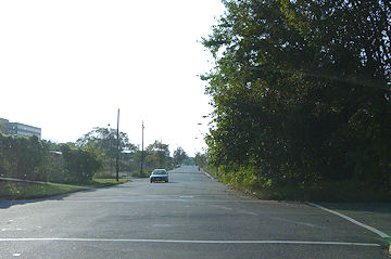
Reader T reports from Maritime Plaza that demolition has begun on the decommissioned ramps between RFK and the 11th Street Bridges. (You can see some photos in the archive or check out the Google Maps overhead view if you're not quite placing them; they're the ones that bend east from 11th Street, not the ones that bend west across 11th.) This is a first step in the five-year plan to reconstruct the 11th Street Bridges and the various approaches; there are also plans to eventually bring the sunken spur of the freeway that goes to Pennsylvania Avenue up to street level as a boulevard, but that's not part of the bridges project. See my 11th Street Bridges page for more on the project; it's expected that initial in-water work on the bridges reconstruction will begin in August.
|
Comments (0)
More posts:
11th Street Bridges
|
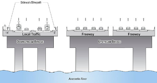
Dr. Gridlock reports that this morning the mayor held a press conference to (officially?) announce that the city will be rebuilding the 11th Street Bridges, with "in-water" work beginning in August. My project page gives the basics on what will be happening (along with links to the EIS), if you haven't been following along, but here's the high-speed recap: still two spans, but the upriver one would be expanded to become an eight-lane freeway span that would add the missing connection ramps between I-395 and I-295, while the downriver span would be four-lane "local" span tieing together Anacostia and Near Southeast, with pedestrian and bike paths and would be prepped for eventual streetcar usage. The project is expected to be completed in 2013.
UPDATE: The press release from DDOT has just come out, and apparently the real announcement of the day was the awarding of the design/build contract for the project to Skanska/Facchina.
UPDATE II: Additional pieces, from WTOP and from the Examiner, which talks about the lawsuit filed in February by the Capitol Hill Restoration Society to stop the project.
|
Comments (0)
More posts:
11th Street Bridges, streetcars, Traffic Issues
|
All sorts of tidbits came down the pike in the past 24 hours. In no particular order:
* I didn't make Tuesday night's Anacostia Waterfront Forum, but the presentation slides ("Economics of Developing the Anacostia River") have been posted. The slides have a good batch of economic data and detail for those interested; it's estimated that there could be nearly $6.7 billion in public investment along the river over the next three decades. In addition, the February forum is now available via streaming video, and the next forum has been scheduled for April 21, with the topic being "Green Waterfront, Green Jobs, Green Living in a Green DC." (The March "Waterfront Watch" newsletter has these additional tidbits, plus stories on the DC streetcar project and the Diamond Teague Park groundbreaking.)
* The WashTimes's Tim Lemke gets a first peek (along with suiteholders) of what new concessionaire Levy Restaurants might have in store for Nationals Park this season.
* Via the eckington blog, a list of the "shovel-ready" transportation projects in the district being funded by ARRA (aka "the stimulus package"). Apparently the demolition of the ramps connecting the 11th Street Bridges and RFK were on the request list, but didn't make the final cut. DDOT's been saying for a while that this demolition would happen Any Minute Now. (Read more about DC and the stimulus package at recovery.dc.gov.)
* Back in December, the owners of the 810/816/820 Potomac Avenue properties (the building that houses Quizno's, the abandoned apartment building, and the space between) announced a sealed bid sale for the lots. While some bids have been submitted (interest from hotels keeps getting mentioned in the communiques I've received from the landowner), the original March 15 deadline has been extended by another 30 days.
* A link that I saw this morning that I've subsequently lost says that the Circulator route replacing the N22 from Union Station to New Jersey and M will begin on March 30.
* Two readers reported that the 55 M construction cam has been turned off. For the first time since 2006, there are no active web cams in the neighborhood. Waaah!
* Another reader reported that the sign put up in 2006 at the corner of Second and M advertising 250 M Street ("Delivery 2008") has been replaced with a new sign, minus any delivery date.
* I know that it's been a *long* time since I've posted new photos. I had grand thoughts of going out this morning, until I looked at the radar. I'm hoping to take some this weekend, though I have a very tricky schedule to work around. But at least know that I'm now feeling guilty about it.
|
Comments (0)
More posts:
11th Street Bridges, 250 M/New DDOT HQ, 816-20 Potomac, circulator, Monument Valley/Half St., Nationals Park, streetcars, Teague Park
|
* (h/t reader F) The AP takes a look at the Capitol Power Plant just north of the SE Freeway, the neighborhood's second most "favorite" landmark (after the school buses) with its smokestacks obscuring the view of the Capitol dome from many locations. On Thursday, Harry Reid and Nancy Pelosi wrote a letter to the Architect of the Capitol asking that the power plant switch from burning coal to using natural gas for its operations, saying "The switch to natural gas will allow the CPP to dramatically reduce carbon and criteria pollutant emissions, eliminating more than 95 percent of sulfur oxides and at least 50 percent of carbon monoxide...We strongly encourage you to move forward aggressively with us on a comprehensive set of policies for the entire Capitol complex and the entire Legislative Branch to quickly reduce emissions and petroleum consumption through energy efficiency, renewable energy, and clean alternative fuels." The AP's story tells how Congress has been trying to clean up the plant and make it more "green," and the potholes in the road to making it run completely on natural gas. I'm guessing it wouldn't be wise to start counting the minutes until the smokestacks are gone.
* On Monday at 6:30 pm the Zoning Commission is scheduled to have its hearing on the Phase 2 plans for the park at The Yards, though we'll see if the weather wreaks havoc with the schedule. Here's my notes on the presentation of the designs to ANC 6D, and my Yards Park page has renderings.
* (UPDATE) Missed this--the Examiner reported on Friday that the Capitol Hill Restoration Society has filed suit to stop construction of the new 11th Street Bridges, citing its "significant, irreversible, adverse effects" on the surrounding area. The CHRS web site has a bit more detail as well.
* Tickets still available for Elton and Billy. Apparently there was a bit of a glitch yesterday when they went on sale.
|
Comments (0)
More posts:
11th Street Bridges, meetings, Stadium Events, Traffic Issues, The Yards, Yards Park, zoning
|
* With thanks to SWill for passing the word (since I couldn't attend the meeting), I can report that ANC 6D on Monday night voted to support the plans for phase 2 of the Yards Park, which will be going in front of the Zoning Commission on March 2. (You can read my summary of last week's presentation to the ANC on the plans for more information.)
* If you're looking for analysis of what exactly the plans for the new 11th Street Bridges configuration might mean, Greater Greater Washington is taking a look at them (part one here; part two not yet posted). For what might perhaps be called an opposing viewpoint, DDOT's chief engineer Kathleen Penney contributed this article in the February Hill Rag about what DDOT sees as the benefits of the project. And, if you want some 11th Street Bridges material to use as a sleeping aid, I pass along this link (via Tommy Wells's blog) to the RFP for the design/build contract. (The "amendment" link is the *slightly* more comprehensible one.) There was a hearing last week on a bill about the contracting procedures for the bridge, but I'm not *so* desperate for content to wade into that.
(UPDATE) I already posted about this, but it's a good time to mention again that there's a public forum on the 11th Street Bridges on Feb. 17: "Sustainable Development, Infrastructure, and the Future of the District of Columbia," at the MLK Library at 6:30 pm. (DDOT just sent around its own announcement, now posted online.)
* And hey, check it out, the council has finally updated the user interface for its legislation database!
* Other than that, all is very quiet these days. Though those following my Twittering were apprised yesterday of this breaking news item: "[I] Dreamt last night that 3rd and K Market was reopening both as a bodega and a swank Indian food joint. With a new noodle place next door."
|
Comments (0)
|
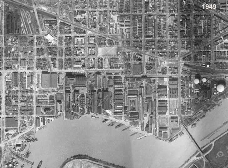 With great thanks to reader G. for passing this along, I can report that the newly released Google Earth 5.0 (beta, of course) now includes an option to page back through older satellite photos. As you might imagine, I raced to see what they had for Near Southeast, and found a not-razor-sharp 1949 image, which you can see on my Near Southeast Satellite Photos page if you don't have Google Earth.
You might enjoy the "Where's Waldo?" test of looking for buildings you recognize, such as the Southeastern Bus Garage, the WASA buildings, and even that big brick warehouse at South Capitol and O that was demolished to make way for the ballpark. Things that *aren't* there: the Southeast Freeway (built in the 1960s), the second span of the 11th Street Bridges, a completed Douglass Bridge, and many of the Capper buildings that came in the 1950s. You'll also see how packed with buildings the Navy Yard was, especially since this was still during the time that its boundaries stretched all the way to First Street (across what is now The Yards). And look at how, north of Virginia Avenue, Garfield Park was bisected by Second Street.
The other image offerings from Near Southeast are mostly variants on the ones I already have on my satellite photos page that came from non-Google sources over the years (1988, 2002, 2004, 2006, 2007), though there are a few extras from the later years where the quality of the image isn't all that good.
If this is whetting your appetite, I also have a batch of non-satellite historic photos of the neighborhood you can wander through, along with detailed street maps from 1903 through 1921.
UPDATE: Commenter MJM rightly reminds me of a fact that an American History major such as myself should have remembered: Sputnik was the first *satellite*, launched in 1957. So these overhead images from 1949 are not satellite images, but were taken from planes. Or they attached a camera to Superman and had him fly around the globe a few times.
|
Comments (0)
|
Some items from the past few days. Big ones first:
* It's probably been true for weeks, but I've just now been by Diamond Teague Park for the first time in a while and can confirm that construction is definitely underway there. Fences are up, cranes (three of them?) are in place, and workers were there. Pictures tomorrow. (Probably *lots* of pictures tomorrow from all over, as long as the weather stays reasonably clear.)
* City Paper got its hands on the letter Mayor Fenty sent to DC Delegate Norton about the city's priorities should the Feds decide to toss some stimulus package dollars in this direction. As I predicted, the two Near Southeast bridge projects were mentioned: "In particular, aspects of the Eleventh Street and South Capitol Street Bridge replacement projects could be undertaken immediately." He also mentions the city's backlog of maintenance projects, along with investments in Metro and the implentation of the streetcar project. And school modernization. And public safety issues.And environmental initiatives. And housing affordability. And health care. (And now here's the stimulus bill itself, though it doesn't get down into specific projects. On the other hand, considering these two bridges ease the commutes to and from the district of the House Majority Leader....)
* Back in mid-November, the transfer of the plot of land known as Reservation 17A from the Feds to the city finally took place; it runs between New Jersey Avenue and Second Street, and is straddled by the trash transfer station building. With this now under District control, various wheels can start turning in that area, including allowing the establishment of I Street between Second and New Jersey that will form the southern boundary of WC Smith's 800 New Jersey Avenue project. There's hopes that the trash transfer station could be demolished in 2010.
* Reader T. reported yesterday that a small bought-at-the-hardware-store For Sale sign went up at 10th and M yesterday, in front of the fence of the Exxon station. I'm not sure what the deal is, since the land is actually owned by the Exxon Corporation, and you'd think they'd have better methods of marketing the land.
* The public notice for the March 19 Zoning Commission hearing on various Capper PUD alteration requests is now available.
* WBJ reports that the Nationals have parted ways with Centerplate, last year's concessionare at the ballpark. This year it will be Levy Restaurants for the food and Facility Merchandising Inc. for the retail.
* More of the fences are coming down at 55 M, as you can see on the web cam. (Though it took me more than a month to notice that the plywood "tunnel" at the Metro exit had disappeared.)
* The Douglass Bridge will be closed at 5 am Sunday until 10am-ish to test the swing span.
|
Comments (0)
More posts:
11th Street Bridges, 55 M St., Trash Transfer Site/DPW, Monument Valley/Half St., New Jersey Ave., Douglass Bridge, WC Smith/Square 737, streetcars, Teague Park, Traffic Issues, zoning
|
159 Posts:
Go to Page: 1 | 2 | 3 | 4 | 5 | 6 | 7 | 8 | 9 | 10 ... 16
Search JDLand Blog Posts by Date or Category
Go to Page: 1 | 2 | 3 | 4 | 5 | 6 | 7 | 8 | 9 | 10 ... 16
Search JDLand Blog Posts by Date or Category