
|
| |||||||||||||||||||

|
Please note that JDLand is no longer being updated.
peek >>
Near Southeast DC Past News Items: 11th Street Bridges

|
See JDLand's 11th Street Bridges Project Page
for Photos, History, and Details |
- Full Neighborhood Development MapThere's a lot more than just the projects listed here. See the complete map of completed, underway, and proposed projects all across the neighborhood.
- What's New This YearA quick look at what's arrived or been announced since the end of the 2018 baseball season.
- Food Options, Now and Coming SoonThere's now plenty of food options in the neighborhood. Click to see what's here, and what's coming.
![-]()
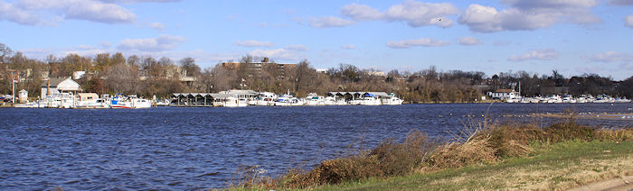
- Anacostia RiverwalkA bridge between Teague and Yards Parks is part of the planned 20-mile Anacostia Riverwalk multi-use trail along the east and west banks of the Anacostia River.
![-]()
- Virginia Ave. Tunnel ExpansionConstruction underway in 2015 to expand the 106-year-old tunnel to allow for a second track and double-height cars. Expected completion 2018.
![-]()
- Rail and Bus Times
Get real time data for the Navy Yard subway, Circulator, Bikeshare, and bus lines, plus additional transit information. - Rail and Bus Times
Get real time data for the Navy Yard subway, Circulator, Bikeshare, and bus lines, plus additional transit information. - Canal ParkThree-block park on the site of the old Washington Canal. Construction begun in spring 2011, opened Nov. 16, 2012.
![-]()
- Nationals Park21-acre site, 41,000-seat ballpark, construction begun May 2006, Opening Day March 30, 2008.
![-]()
- Washington Navy YardHeadquarters of the Naval District Washington, established in 1799.
![-]()
- Yards Park5.5-acre park on the banks of the Anacostia. First phase completed September 2010.
![-]()
- Van Ness Elementary SchoolDC Public School, closed in 2006, but reopening in stages beginning in 2015.
![-]()
- Agora/Whole Foods336-unit apartment building at 800 New Jersey Ave., SE. Construction begun June 2014, move-ins underway early 2018. Whole Foods expected to open in late 2018.
![-]()
- New Douglass BridgeConstruction underway in early 2018 on the replacement for the current South Capitol Street Bridge. Completion expected in 2021.
![-]()
- 1221 Van290-unit residential building with 26,000 sf retail. Underway late 2015, completed early 2018.

- NAB HQ/AvidianNew headquarters for National Association of Broadcasters, along with a 163-unit condo building. Construction underway early 2017.

- Yards/Parcel O Residential ProjectsThe Bower, a 138-unit condo building by PN Hoffman, and The Guild, a 190-unit rental building by Forest City on the southeast corner of 4th and Tingey. Underway fall 2016, delivery 2018.

- New DC Water HQA wrap-around six-story addition to the existing O Street Pumping Station. Construction underway in 2016, with completion in 2018.

- The Harlow/Square 769N AptsMixed-income rental building with 176 units, including 36 public housing units. Underway early 2017, delivery 2019.

- West Half Residential420-unit project with 65,000 sf retail. Construction underway spring 2017.
![-]()
- Novel South Capitol/2 I St.530ish-unit apartment building in two phases, on old McDonald's site. Construction underway early 2017, completed summer 2019.
![Novel South Capitol]()
- 1250 Half/Envy310 rental units at 1250, 123 condos at Envy, 60,000 square feet of retail. Underway spring 2017.
![-]()
- Parc Riverside Phase II314ish-unit residential building at 1010 Half St., SE, by Toll Bros. Construction underway summer 2017.
![-]()
- 99 M StreetA 224,000-square-foot office building by Skanska for the corner of 1st and M. Underway fall 2015, substantially complete summer 2018. Circa and an unnamed sibling restaurant announced tenants.
![-]()
- The Garrett375-unit rental building at 2nd and I with 13,000 sq ft retail. Construction underway late fall 2017.
![-]()
- Yards/The Estate Apts. and Thompson Hotel270-unit rental building and 227-room Thompson Hotel, with 20,000 sq ft retail total. Construction underway fall 2017.
![-]()
- Meridian on First275-unit residential building, by Paradigm. Construction underway early 2018.
![-]()
- The Maren/71 Potomac264-unit residential building with 12,500 sq ft retail, underway spring 2018. Phase 2 of RiverFront on the Anacostia development.
![-]()
- DC Crossing/Square 696Block bought in 2016 by Tishman Speyer, with plans for 800 apartment units and 44,000 square feet of retail in two phases. Digging underway April 2018.
![DC Crossing]()
- One Hill South Phase 2300ish-unit unnamed sibling building at South Capitol and I. Work underway summer 2018.
![One Hill South Phase 2]()
- New DDOT HQ/250 MNew headquarters for the District Department of Transportation. Underway early 2019.
![New DDOT HQ]()
- 37 L Street Condos11-story, 74-unit condo building west of Half St. Underway early 2019.
![37 L Condos]()
- CSX East Residential/Hotel225ish-unit AC Marriott and two residential buildings planned. Digging underway late summer 2019.
![CSX East Residential/Hotel]()
- 1000 South Capitol Residential224-unit apartment building by Lerner. Underway fall 2019.
![1000 South Capitol Residential]()
- Capper Seniors 2.0Reconstruction of the 160-unit building for low-income seniors that was destroyed by fire in 2018.
![1000 South Capitol Residential]()
- Chemonics HQNew 285,000-sq-ft office building with 14,000 sq ft of retail. Expected delivery 2021.
![1000 South Capitol Residential]()


159 Blog Posts Since 2003
Go to Page: 1 | 2 | 3 | 4 | 5 | 6 | 7 | 8 | 9 | 10 ... 16
Search JDLand Blog Posts by Date or Category
Go to Page: 1 | 2 | 3 | 4 | 5 | 6 | 7 | 8 | 9 | 10 ... 16
Search JDLand Blog Posts by Date or Category
Some items from the past few days. Big ones first:
* It's probably been true for weeks, but I've just now been by Diamond Teague Park for the first time in a while and can confirm that construction is definitely underway there. Fences are up, cranes (three of them?) are in place, and workers were there. Pictures tomorrow. (Probably *lots* of pictures tomorrow from all over, as long as the weather stays reasonably clear.)
* City Paper got its hands on the letter Mayor Fenty sent to DC Delegate Norton about the city's priorities should the Feds decide to toss some stimulus package dollars in this direction. As I predicted, the two Near Southeast bridge projects were mentioned: "In particular, aspects of the Eleventh Street and South Capitol Street Bridge replacement projects could be undertaken immediately." He also mentions the city's backlog of maintenance projects, along with investments in Metro and the implentation of the streetcar project. And school modernization. And public safety issues.And environmental initiatives. And housing affordability. And health care. (And now here's the stimulus bill itself, though it doesn't get down into specific projects. On the other hand, considering these two bridges ease the commutes to and from the district of the House Majority Leader....)
* Back in mid-November, the transfer of the plot of land known as Reservation 17A from the Feds to the city finally took place; it runs between New Jersey Avenue and Second Street, and is straddled by the trash transfer station building. With this now under District control, various wheels can start turning in that area, including allowing the establishment of I Street between Second and New Jersey that will form the southern boundary of WC Smith's 800 New Jersey Avenue project. There's hopes that the trash transfer station could be demolished in 2010.
* Reader T. reported yesterday that a small bought-at-the-hardware-store For Sale sign went up at 10th and M yesterday, in front of the fence of the Exxon station. I'm not sure what the deal is, since the land is actually owned by the Exxon Corporation, and you'd think they'd have better methods of marketing the land.
* The public notice for the March 19 Zoning Commission hearing on various Capper PUD alteration requests is now available.
* WBJ reports that the Nationals have parted ways with Centerplate, last year's concessionare at the ballpark. This year it will be Levy Restaurants for the food and Facility Merchandising Inc. for the retail.
* More of the fences are coming down at 55 M, as you can see on the web cam. (Though it took me more than a month to notice that the plywood "tunnel" at the Metro exit had disappeared.)
* The Douglass Bridge will be closed at 5 am Sunday until 10am-ish to test the swing span.
|
Comments (0)
More posts:
11th Street Bridges, 55 M St., Trash Transfer Site/DPW, Monument Valley/Half St., New Jersey Ave., Douglass Bridge, WC Smith/Square 737, streetcars, Teague Park, Traffic Issues, zoning
|
Inauguration Day Street Closures/Public Entry Points; Much of Near Southeast to Be Closed to Traffic
This afternoon the Secret Service and local jurisdictions released the Inauguration Joint Transportation Plan (the list of street closings and restrictions), and a map that shows the main closures and restrictions around the Mall, as well as where visitors will be able to enter the Mall and the parade route. I'll let the major media outlets dissect what it means city-wide, but for Near Southeast, here's the early scoop:
* The Southeast-Southwest Freeway, the 11th Street Bridges, and the South Capitol Street (Frederick Douglass) Bridge will be restricted to buses and authorized vehicles only.
* Although no streets in Near Southeast are specifically listed in the Secret Service's batch of street closings, that doesn't mean that they aren't going to be a whole bunch of closures. I mentioned a few days back that much of Near Southeast will be bus-only parking, and apparently the specific streets have now been decided on. And, according to the city's web site on Inauguration Day Street Restrictions, the Emergency No Parking Zones will be established starting at 3 pm Monday, Jan. 19, with the streets then being closed beginning at 12:01 am Tuesday Jan. 20, through 12:01 am Wednesday, Jan. 21 to vehicular traffic except for "charter buses, metro buses, taxis, postal vehicles, law enforcement vehicles and emergency vehicles, as well as residents with government issued identification or vehicle registration showing residency inside the restricted area" (emphasis mine).
It would be great if they posted a map, because the lists of streets are pretty hard to work with. It looks like M Street and Virginia Avenue will be closed to Ninth Street, Half and First will be closed from I Street to N Street, New Jersey will be closed from I to M, and I, K, and L, will be closed to Sixth Street. So, this would mean that north/south streets from Third eastward will be open between M and the freeway.
* There's also this on the city street closure page, which I can't quite decipher: "The following access points have been identified as pedestrian-only routes to the National Mall: [...] East Capitol Street, NE to North Carolina, SE to New Jersey Avenue, SE to I Street, SE." I guess this means these streets will be closed to traffic and will be where pedestrians are funneled to? (But then, where to? Up South Capitol?) Like I said, I need a map!
More to come, I'm sure, especially once all the media's mapmakers get on the case.
My advice? Do what I'm going to do--pretend there's a snowstorm a'comin, get a week's worth of provisions ahead of time, and just hunker down until Wednesday, with no plans to go anywhere except on foot.
|
Comments (0)
|
On Tuesday night the Office of Planning and the Deputy Mayor's office held a third public meeting as part of the planning process undertaken this year for Boathouse Row, the stretch of land along the western shore of the Anacostia from the 11th Street Bridges upstream. Much of this area has been owned and managed by the federal government for years and years, but is part of the batch of parcels being transferred back to DC (and on Thursday the mayor will be announcing was supposed to be announcing that this swap is finally complete, but the event has been postponed because of a scheduling issue with the Secretary of the Interior). With the District preparing to take control of the property, and with the Anacostia Waterfront Initiative looking to transform the city's relationship with the river, it was decided to take a step back and do some "visioning" of what this area could be if given the proper TLC. (Michael Durso of DMPED also took great pains to emphasize that there are no plans to dispose of this land to developers or other interests.)
One big surprise for this newcomer was that the city does not expect to begin any of the transformation of this area for another *ten* years or so, given the constraints of large close-by projects starting in the next few years such as the 11th Street Bridges rehabilitation, remediation of the contaminated Washington Gas site east of 12th Street, and WASA's Deep Tunnel project. (And I will admit that hearing that ten-year timeframe made me feel a little less bad about having come to this planning process so late in the game!)
Also, the slides from the Tuesday meeting aren't yet posted online, so I think I will wait to delve into the details of all of this until those are available. But the study has now boiled down the wants and needs of various stakeholders into two concept alternatives, one of which imagines a $38 million project, $23 million of which would be dredging to allow for deeper-water boats farther up river (at least, that's how this non-boating-savvy blogger understood it), and the other which determines uses of the riverfront and the water if dredging does not take place, at a cost of about $13 million. Both concepts incorporate sustainable design, linked open spaces allowing for activities such as picnic areas, and amenities and shared uses like a small canteen and bike racks (and perhaps a bike rental oulet).
It's expected that the final report will be released in early January, followed by a 30-day comment period.
In the meantime, the operations of the Anacostia Community Boathouse Association will be moving from its spot in between the 11th Street Bridges spans to the marina just east of the Pennsylvania Avenue/Sousa Bridge (outside my boundaries!) in 2009; both Boathouse Row design concepts have ACBA returning after the bridge work is completed, perhaps with an expanded presence on the land just east of the bridges.
(Also, for people interested in the planned "boulevardization" of the old Southeast Freeway lanes that run from 11th Street to Barney Circle: it was mentioned that this project probably won't happen for another 10 years. But the planners did do some blue-skying of how this work--and perhaps the relocation of the CSX rail lines that also cut off Boathouse Row from its neighbors--could someday allow for this isolated patch of land to be reconnected to Capitol Hill and the rest of the city.)
|
Comments (0)
More posts:
11th Street Bridges, Anacostia Waterfront Initiative, Boathouse Row
|
I have to admit that information fairs aren't quite my gig (especially since I'm immersed in this stuff everyday), but I did wander past today's Anacostia Waterfront Community Information Fair at the ballpark to see what there was to see. I got there pretty early and left pretty early, so didn't see any of the panel discussions (and didn't take any of the bus tours), but if you want to see how they configured the exhibitions within the Stars and Stripes clubs at the ballpark, here's a batch of photos. (And, if you were there, maybe you're in one or two of them!)
I also took a few new photos on First, Third, and New Jersey of 909 New Jersey, Velocity, Onyx, and the Foundry Lofts, which will serve mainly as a reminder of why I don't normally go on photo expeditions on cloudy days. If the weather finally shifts, I expect to be out taking some additional ones on Sunday, especially of 1015 Half, since the first columns are visible above ground-level.
Plus, I felt a burst of inspiration yesterday the likes of which I haven't seen in months, and *finally* created project pages for William C. Smith's 800 New Jersey Avenue development and for the 11th Street Bridges reconstruction. The 800 NJ page has almost no information (since there's so little to be had about the project beyond the basic 1.1-mil-office-residential-retail-and-maybe-Whole-Foods profile); the 11th Street Bridges page is a little better, but still is just a lot of pictures of overpasses and flyovers. Better than nothing in both cases, though!
|
Comments (0)
More posts:
11th Street Bridges, Foundry Lofts/Yards, Onyx, Retail, WC Smith/Square 737, Square 699n, Nationals Park, Velocity Condos, The Yards
|
This morning Mayor Fenty held a press conference at Nationals Park with various city officials to highlight tomorrow's Anacostia Waterfront Information Fair, and also talk up the recent progress and near-term next steps for the more than $8 billion worth of economic development, transportation, and infrastructure projects in the pipeline along the Anacostia River (not only in Near Southeast, but from the Southwest Waterfront all the way up past RFK).
Having sworn off taking any more photos of The Mayor at the Microphone (unless he shows up in a Hawaiian shirt and swimtrunks or something), I decided to record the 20-minute event instead, so that the five or six of you interested in hearing the remarks can do so. (It's a 2.6-mb MP3 file; the first few seconds are rough, but then it settles in.)
If you listen, you'll hear how the mayor managed to cajole the notoriously camera-shy Stan Kasten into saying a few words about what's happening along the river and in the neighborhood from the point of view of the area's largest tenant. Deputy Mayor Neil Albert, DDOT Director Frank Seales, Office of Planning head Harriet Tregoning, and the director of the city's Office of the Environment George Hawkins spoke as well. There was some discussion throughout (and especially at the end) about how the slowing economy might be impacting both the city's plans and developers' projects, but the mayor remains optimistic.
The press release from the mayor's office sums up the main points of today's event, but here's the Near Southeast-specific highlights from both the remarks and some other chatter of the day. First up, news of the three big parks:
The city "will break ground at Diamond Teague Park by the end of 2008." (And the guide for tomorrow's fair says that the park will be completed in spring 2009, which is the same date we've been hearing for a while.) The mayor also touted the operating agreement with Forest City Washington to build and maintain the $42 million, 5-acre Park at the Yards (but you knew about this already), as well as the the agreement with the Canal Park Development Corp. to build the $13.1 million, three-block-long park. (No mention of school buses.)
Then there's the bridges: Reconstruction of the 11th Street Bridges is scheduled to begin in mid-2009. (The shortlist of firms vying for the design-build contract was announced a few weeks ago.) Whether we actually see heavy equipment moving in mid-2009, or whether this just marks the first part of the design-build project is not quite clear. I was also told that the contract to demolish the flyover ramps to and from RFK could be completed soon, and that demolition would happen not long after the contract is signed.
Plus, the final Environmental Impact Statement for South Capitol Street and the Douglass Bridge is expected in spring 2009; that's when we'll hear which of the four bridge designs has been chosen.
As for the river itself, the city has started real-time water quality monitoring, updated automatically online 24 hours a day. There's also now the Anacostia 2032 Plan "to make the Anacostia River boatable, swimmable, and fishable in 25 years." And a Green Summer Jobs Corps was created earlier this year to "engage youth in the cleaning and greening of District neighborhoods and parks and to introduce them to green-collar job opportunities."
Finally, a planning process is underway to revamp Boathouse Row, the stretch of boat clubs along the Anacostia between 11th Street and Pennsylvania Avenue. (I took a bunch of photos near the boathouses a few months back, and have been lazy about ever getting them posted, though you can see a few boathouse-free shots of the environs here and here.)
There's more about projects elsewhere along the Anacostia, but other bloggers get to cover those. Will update this post if there's any media coverage from today's event, and will have a fresh post on Saturday after the fair. I imagine I'll Twitter a bit from those festivities (like I did from today's); remember that if you aren't a Twitter-er, you can read my tweets on the JDLand homepage--check 'em out frequently, because I do sometimes post news there first, before I write full blog entries.
SATURDAY FAIR UPDATE: They're now going to be providing free shuttle bus service from the New Jersey & M Metro entrance to/from the ballpark, from 12:30 pm to 5:15 pm. (After they heard somewhere that the Half and M subway entrance is going to be closed on Saturday.)
|
Comments (0)
More posts:
11th Street Bridges, Boathouse Row, Canal Park, Douglass Bridge, Nationals Park, Teague Park, The Yards, Yards Park
|
* The ANC 6D agenda for its meeting on Monday Oct. 20 has been sent around (though not yet posted online). There will be a discussion of the Ballpark Traffic Operations and Parking Plan as it relates to Southwest, plus public space requests for building signage at 909 New Jersey and "Brick Walls for Trash Enclosures" at Capitol Quarter. (These are also on the Oct. 23 agenda of the city's Public Space Commitee.)
* The short list for a design/build team to reconstruct the 11th Street Bridges is out--Shirley Design-Build LLC, Skansa/Facchina, Archer Western Contractors LLC, Perini/Parsons Joint Venture, and KCA Constructors Joint Venture. According to the procurement schedule, a draft RFP should already be out (haven't found it online), and final RFP should be issued by the end of the year, with a contract signed with the vendor by June 1, 2009.
* Metro announced yesterday that 53 percent of baseball game attendees this year arrived at Nationals Park via Metrorail. That's 1.8 million bodies, averaging 23,000 people entering and exiting the Navy Yard station at the 80 home games in 2008. (It apparently doesn't count people who took the bus or walked down from Capitol South.) In the last two years at RFK, only 38 percent of attendees took the subway. Marc Fisher has some thoughts on it all (including some questions on Metro's math).
|
Comments (0)
More posts:
11th Street Bridges, 909 New Jersey, ANC News, Capper, Capitol Quarter, jpi, Metro/WMATA, parking, Nationals Park
|
* The Congress for the New Urbanism has named the 11th Street Bridges (along with the Southeast Freeway) to its Freeways Without Futures list, recognizing the top 10 locations in the U.S. "where the opportunity is greatest to stimulate valuable revitalization by replacing aging urban highways with boulevards and other cost-saving urban alternatives." It mentions the opposition of the Capitol Hill Restoration Society to the plans to reconstruct the 11th Street Bridges, scheduled to start next year.
* A few folks wrote in to mention that there's a new sign up advertising the planned office building at 1111 New Jersey. Despite some building permits recently in the pipeline, developer Donohoe told me a few weeks ago that no announcement of a groundbreaking is imminent.
* I seem to always manage to be out of town during WalkingTown DC, and so missed last weekend's jaunt around the "Capitol Riverfront." Blogger fourthandeye from The Triangle was there, however, and gives a nice overview via eyes that don't look at these streets every day.
* The weather forecast does not look good for Thursday night's final home game of the season at Nationals Park.
|
Comments (0)
|
Not quite a month after sending out a request for expressions of interest, DDOT has now released the official Request for Qualifications for what is now being referred to as the 11th Street Corridor Design-Build Project, the heart of which is the reconstruction of the 11th Street Bridges. According to the press release:, DDOT will then create a short list of between two and five submitters, and will release the official Request for Proposals to just those entities. The procurement schedule says that the statements of qualifications are due by Sept. 29, with the shortlisters to be notified by October 10, and a final RFP then released by Dec. 1. The entire selection process, up to an including a contract, is targeted for completion by June 1, 2009. DDOT is shooting for completing the entire project by Dec. 31, 2013, with a budget of $260 million. (Mark your calendars--I have!) The new Anacostia Waterfront web site has more about the 11th Street Bridges project, and the other plans along the river from the Southwest Waterfront up to Kingman Island.
|
Comments (0)
More posts:
11th Street Bridges
|
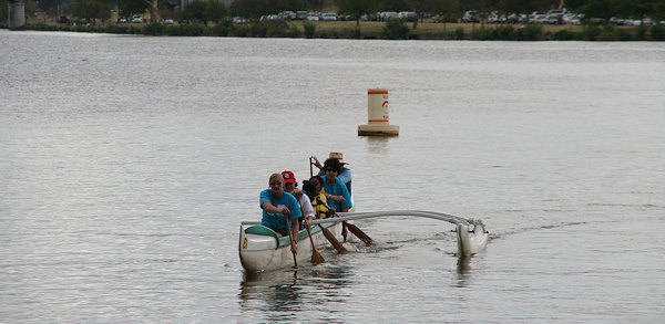
Saturday was the Youth River Sports Day at the Anacostia Community Boathouse, and there was a good turnout of parents and kids learning how to row or paddle or just getting acquainted with the Anacostia River. I took a batch of photos, all from dry land. (If the captions have any incorrect terminology, let me know.)
The ACBA is going to have to temporarily relocate from this spot during the five-year reconstruction of the 11th Street Bridges. They may be moving a couple hundred feet upriver to a site owned by Washington Gas (as laid out in the final Environmental Impact Statement for the project), or they may end up on the eastern side of the river closer to the Sousa Bridge. They are working with DDOT and are hopeful they can get the plans straightened out before too much longer.
|
Comments (0)
More posts:
11th Street Bridges, Boathouse Row
|
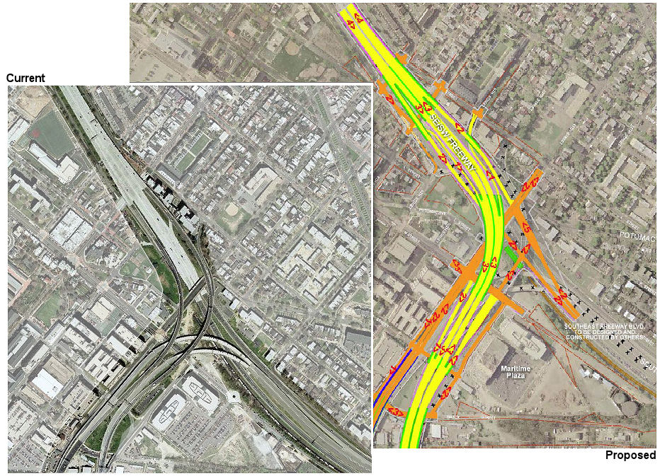 On Wednesday DDOT announced a new web site, called Anacostia Waterfront: Realizing the Vision. It's billed as a "centralized location for updates about the Anacostia Waterfront, as well as project-specific information and links," though as of now the only detailed project information is for the plans to replace the 11th Street Bridges, there there are also links to the Anacostia Waterfront Framework Plan and the Comprehensive Plan.
 The items on the 11th Street Bridges include those that I blogged about late last week, as the city starts to move forward to procure design/build services for the project. They've posted the presentation slides from Monday's informational meeting, which mention the goal of meeting or beating the construction completion date of Dec. 31, 2013 (mark your calendars). DDOT expects to release the Request for Qualifications on Aug. 15, followed by a Request for Proposals by the end of the year, with a contractor selection and agreement completed by June of 2009, so that work can begin soon after.
This new web site repeats what I saw on the 11th Street Bridges EIS web site, that the city "will remove the existing flyover ramps to RFK this summer," but doesn't have any additional details. (Summer does technically run until mid-September, I guess.)
|
Comments (0)
More posts:
11th Street Bridges
|
159 Posts:
Go to Page: 1 | 2 | 3 | 4 | 5 | 6 | 7 | 8 | 9 | 10 ... 16
Search JDLand Blog Posts by Date or Category
Go to Page: 1 | 2 | 3 | 4 | 5 | 6 | 7 | 8 | 9 | 10 ... 16
Search JDLand Blog Posts by Date or Category