
|
| |||||||||||||||||||

|
Please note that JDLand is no longer being updated.
peek >>
Near Southeast DC Past News Items
- Full Neighborhood Development MapThere's a lot more than just the projects listed here. See the complete map of completed, underway, and proposed projects all across the neighborhood.
- What's New This YearA quick look at what's arrived or been announced since the end of the 2018 baseball season.
- Food Options, Now and Coming SoonThere's now plenty of food options in the neighborhood. Click to see what's here, and what's coming.
![-]()
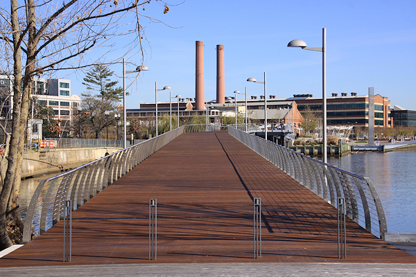
- Anacostia RiverwalkA bridge between Teague and Yards Parks is part of the planned 20-mile Anacostia Riverwalk multi-use trail along the east and west banks of the Anacostia River.
![-]()
- Virginia Ave. Tunnel ExpansionConstruction underway in 2015 to expand the 106-year-old tunnel to allow for a second track and double-height cars. Expected completion 2018.
![-]()
- Rail and Bus Times
Get real time data for the Navy Yard subway, Circulator, Bikeshare, and bus lines, plus additional transit information. - Rail and Bus Times
Get real time data for the Navy Yard subway, Circulator, Bikeshare, and bus lines, plus additional transit information. - Canal ParkThree-block park on the site of the old Washington Canal. Construction begun in spring 2011, opened Nov. 16, 2012.
![-]()
- Nationals Park21-acre site, 41,000-seat ballpark, construction begun May 2006, Opening Day March 30, 2008.
![-]()
- Washington Navy YardHeadquarters of the Naval District Washington, established in 1799.
![-]()
- Yards Park5.5-acre park on the banks of the Anacostia. First phase completed September 2010.
![-]()
- Van Ness Elementary SchoolDC Public School, closed in 2006, but reopening in stages beginning in 2015.
![-]()
- Agora/Whole Foods336-unit apartment building at 800 New Jersey Ave., SE. Construction begun June 2014, move-ins underway early 2018. Whole Foods expected to open in late 2018.
![-]()
- New Douglass BridgeConstruction underway in early 2018 on the replacement for the current South Capitol Street Bridge. Completion expected in 2021.
![-]()
- 1221 Van290-unit residential building with 26,000 sf retail. Underway late 2015, completed early 2018.

- NAB HQ/AvidianNew headquarters for National Association of Broadcasters, along with a 163-unit condo building. Construction underway early 2017.

- Yards/Parcel O Residential ProjectsThe Bower, a 138-unit condo building by PN Hoffman, and The Guild, a 190-unit rental building by Forest City on the southeast corner of 4th and Tingey. Underway fall 2016, delivery 2018.

- New DC Water HQA wrap-around six-story addition to the existing O Street Pumping Station. Construction underway in 2016, with completion in 2018.

- The Harlow/Square 769N AptsMixed-income rental building with 176 units, including 36 public housing units. Underway early 2017, delivery 2019.

- West Half Residential420-unit project with 65,000 sf retail. Construction underway spring 2017.
![-]()
- Novel South Capitol/2 I St.530ish-unit apartment building in two phases, on old McDonald's site. Construction underway early 2017, completed summer 2019.
![Novel South Capitol]()
- 1250 Half/Envy310 rental units at 1250, 123 condos at Envy, 60,000 square feet of retail. Underway spring 2017.
![-]()
- Parc Riverside Phase II314ish-unit residential building at 1010 Half St., SE, by Toll Bros. Construction underway summer 2017.
![-]()
- 99 M StreetA 224,000-square-foot office building by Skanska for the corner of 1st and M. Underway fall 2015, substantially complete summer 2018. Circa and an unnamed sibling restaurant announced tenants.
![-]()
- The Garrett375-unit rental building at 2nd and I with 13,000 sq ft retail. Construction underway late fall 2017.
![-]()
- Yards/The Estate Apts. and Thompson Hotel270-unit rental building and 227-room Thompson Hotel, with 20,000 sq ft retail total. Construction underway fall 2017.
![-]()
- Meridian on First275-unit residential building, by Paradigm. Construction underway early 2018.
![-]()
- The Maren/71 Potomac264-unit residential building with 12,500 sq ft retail, underway spring 2018. Phase 2 of RiverFront on the Anacostia development.
![-]()
- DC Crossing/Square 696Block bought in 2016 by Tishman Speyer, with plans for 800 apartment units and 44,000 square feet of retail in two phases. Digging underway April 2018.
![DC Crossing]()
- One Hill South Phase 2300ish-unit unnamed sibling building at South Capitol and I. Work underway summer 2018.
![One Hill South Phase 2]()
- New DDOT HQ/250 MNew headquarters for the District Department of Transportation. Underway early 2019.
![New DDOT HQ]()
- 37 L Street Condos11-story, 74-unit condo building west of Half St. Underway early 2019.
![37 L Condos]()
- CSX East Residential/Hotel225ish-unit AC Marriott and two residential buildings planned. Digging underway late summer 2019.
![CSX East Residential/Hotel]()
- 1000 South Capitol Residential224-unit apartment building by Lerner. Underway fall 2019.
![1000 South Capitol Residential]()
- Capper Seniors 2.0Reconstruction of the 160-unit building for low-income seniors that was destroyed by fire in 2018.
![1000 South Capitol Residential]()
- Chemonics HQNew 285,000-sq-ft office building with 14,000 sq ft of retail. Expected delivery 2021.
![1000 South Capitol Residential]()


2730 Blog Posts Since 2003
Go to Page: 1 | 2 | 3 | 4 | 5 | 6 | 7 | 8 | 9 | 10 ... 273
Search JDLand Blog Posts by Date or Category
Go to Page: 1 | 2 | 3 | 4 | 5 | 6 | 7 | 8 | 9 | 10 ... 273
Search JDLand Blog Posts by Date or Category
In March 2011, I posted on the proposed 2012 tax assessments for the 900-plus tax parcels that I track as Near Southeast properties, which valued the neighborhood at just a teensy bit under $6 billion ($5.994B). But there's a reason those are just "proposed": property owners need a chance to prostrate themselves before the city to try to get their assessments revised. In addition, new properties come onto the rolls during the year as projects get completed. 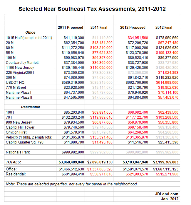 There were 15 properties that received reductions for their 2012 bills, totaling about $148 million. The big property owners managed a few hefty cuts, with JBG's US Department of Transportation building leading the way with a $47.7 million reduction to just under $615 million, followed by CSX's empty lots near the freeway north of I Street getting a $46.3 million haircut down to $66.2 million. Many of the other shiny new-ish buildings of the neighborhood also got their tallies reduced, such as apartment buildings 70/100 I and 909 New Jersey and office buildings 20 M, 55 M, 225 Virginia, and Maritime Plaza I and II.
So, I can now report that the 2012 tax assessment total for Near Southeast is: $6.06 billion. Since the final assessments for 2011 came in at about $5.81 billion, 2012's number is a $248 million increase for actual assessments year-over-year.
There were 15 properties that received reductions for their 2012 bills, totaling about $148 million. The big property owners managed a few hefty cuts, with JBG's US Department of Transportation building leading the way with a $47.7 million reduction to just under $615 million, followed by CSX's empty lots near the freeway north of I Street getting a $46.3 million haircut down to $66.2 million. Many of the other shiny new-ish buildings of the neighborhood also got their tallies reduced, such as apartment buildings 70/100 I and 909 New Jersey and office buildings 20 M, 55 M, 225 Virginia, and Maritime Plaza I and II. But these reductions were offset by $216 million in upward revisions. Most of this is thanks to 1015 Half Street finally being completed, taking that parcel's assessment from last year's $41.1 million to just a hair under $144 million. Three other buildings (80 M, 100 M, and 300 M) received higher final assessments as well. Plus, 32 townhouses in Capitol Quarter came onto the rolls as completed buildings, bringing just under $14 million in new tax revenue. (Yes, yes, PILOT/payment in lieu of taxes--don't stop me when I'm on a roll.)
And, because people always want to know, the ballpark's assessment for 2012 remains the smidgiest smidge under $1 billion, unchanged from 2011, at $999,982,800.
Alas, I can't give good year-to-year comparison numbers on final assessments in previous years because I didn't really grasp this whole revision thing until last year (oops), but I can say that proposed assessments were just a mite over $6 billion in both 2010 and 2011, after having been at $4.47 billion in 2009. My March post has the year-by-year proposed assessed values for the neighborhood, if you want those numbers.
If you feel like digging deeper (since you don't pay me enough to just post all my numbers for you to use), here's the the current assessments database, which you can search yourself. Tune in this March to see what the city proposes for 2013 values, and then in January for what the values really end up being....
|
Comments (0)
More posts:
assessments
|
Hope everyone has had a good holiday season, and made it into the New Year relatively unscathed. I took some blog vacation time myself, but while it's looked like pure slacking, I've actually been hard at work on my 2012 State of the Hood roundup, which will be coming tomorrow.
Until then, here's a few very short tidbits to catch up on, some of which were already tweeted (so blog-only folks might have missed them) and others of which were just little things that have piled up on my To-Do list.
* In the days before Christmas, the final demolitions were finished up at Florida Rock, making the concrete tower #166 in my Demolished Buildings gallery. I didn't get down there for mid-demo photos, but DCMud has a few stylized shots.
* The Capitol Riverfront BID said last week on Facebook that construction will begin in April on turning the Lumber Shed at Yards Park into a combination retail pavilion and office space for developer Forest City. No such announcement from Forest City yet, and no details on who any of the retail tenants may be.
* Suspect fleeing from police jumps the fence into Nationals Park on Dec. 28, finally found hiding in a public restroom.
* The Examiner surveys what's coming for DC's various waterfronts in 2012.
* The Post's annual list includes "Renting in Navy Yard" as one of the "In"s. (To which the smart-ass in me replies, "Oh, you mean actually in the Washington Navy Yard, the Navy's oldest shore establishment, now 202 years old?")
|
Comments (0)
|
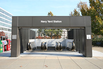 If you're looking for an excuse to have a celebration (and who isn't in the long, seven-day slog between Christmas and New Year's), you can raise a glass on Wednesday to the 20th birthday of the Waterfront, Navy Yard, and Anacostia Metro stations, which opened on Dec. 28, 1991.
Not surprisingly, it was the arrival of DC's subway in Anacostia that was the main focus of opening day celebrations: "At long last, after two decades of planning and delays, site squabbles and legal hurdles, Metro's Green Line came to Anacostia yesterday and Anacostia rolled out a green carpet of welcome," reported the Washington Post.
But, a few days earlier, the Post published a piece focusing on what changes the new Navy Yard station would bring to its surroundings:
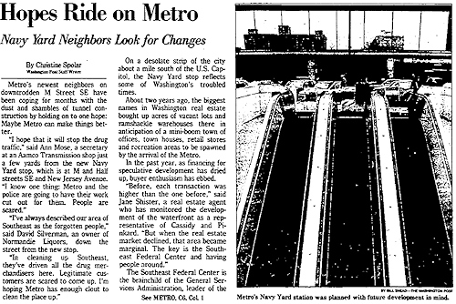 "Metro's newest neighbors on downtrodden M Street SE have been coping for months with the dust and shambles of tunnel construction by holding onto one hope: Maybe Metro can make things better."
"'I hope that it will stop the drug traffic,' said Ann Mose, a secretary at an Aamco Transmission shop just a few yards from the new Navy Yard stop, which is at M and Half streets SE and New Jersey Avenue. 'I know one thing: Metro and the police are going to have their work cut out for them. People are scared.'"
Then, see if this part sounds familiar: "About two years ago, the biggest names in Washington real estate bought up acres of vacant lots and ramshackle warehouses there in anticipation of a mini-boom town of offices, town houses, retail stores and recreation areas to be spawned by the arrival of the Metro. In the past year, as financing for speculative development has dried up, buyer enthusiasm has ebbed."
The article then speaks of the plans to redevelop the Southeast Federal Center with 1 million square feet of office space for 23,000 federal workers at agencies like GSA, the Army Corps of Engineers, the Navy, and perhaps FEMA.
"But today, as Metro cars rumble through test runs on the new extension of the Green Line, those dreams seem obscured by drug traffickers who walk undisturbed up and down M Street, in the shadows of boarded-up buildings that neighbors call crack houses, from which Metro workers solicitously warn visitors to stay away. [...]
"Between that and the subway stop is public housing. Trash piles up on the sidewalk. Hypodermic needles are discarded in open lots.
"'You've got to be something of a visionary to see what this is going to be like in five to 10 years,' GSA administrator Dick Austin said. 'There are a lot of those who are skeptics and say it's not going to happen.... Did you ever see the movie 'Field of Dreams?'"
And, in referencing the commercial developers who had bought up much of the land in the neighborhood, the article says: "Their hopes[...]: that the lackluster waterfront from Buzzard Point to the Washington Navy Yard could be turned into the Tysons Corner of the 21st century."
|
Comments (2)
More posts:
Metro/WMATA, Rearview Mirror
|
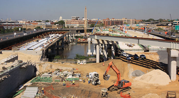
On Wednesday and Thursday (Dec. 28 and 29), watch for closures on 11th Street SE between M and K between 5 am and 4 pm as workers install girders above the street as part of the new flyover connecting the 11th Street Bridges and the Southeast Freeway (or, as we probably need to start calling all of it, I-695). Here's the details, including where the detours will run.
If you've been by that stretch of 11th Street lately, you've seen the girders making their big bend westward, stopping just above 11th Street. (This is the pier that the girders are now being placed on, as seen back in October.) It will certainly change the vista on that stretch. I'll get photos after the girders are in place, and when the sun comes out.
In other 11th Street Bridges news, you probably noticed that the new outbound freeway span didn't open this past weekend, as had been hoped. DDOT tells Dr. Gridlock it will probably now be "early January." "The earlier opening had been a long shot anyway," DDOT spokesman John Lisle is quoted as saying.
|
Comments (1)
More posts:
11th Street Bridges
|


I missed out on Lot 38 Espresso's Grand Opening on Wednesday, because, well, it was raining. (How's that for dedication?) But I wandered down first thing this morning to check out the new digs, and of course snapped a few pictures. (I opted for a hot chocolate, since I am one of those heathens who doesn't drink coffee.) Here's the photos, and I included a couple of the progress on the two pavilions at Canal Park while I was at it.
I should also mention that they're now on Twitter (@Lot38Espresso) and Facebook, and I've added them to my Near SE Businesses Twitter list. Their web site is technically "coming soon," but it does at least list their hours, 6:30 am - 8 pm Monday-Friday, and 7 am - 7 pm Saturday and Sunday.
UPDATE: Here's City Paper's Young and Hungry blog about Lot 38, along with some blurry photos (dude, at least hold the camera still).
|
Comments (10)
|
 It looks like Monument Realty's office building at 55 M Street may be close to getting its first retail tenant, as they have confirmed to me that they are in negotiations with Bank of America for a branch office in one of 55 M's ground-floor spaces, on top of the west entrance to the Navy Yard Metro station, just north of Nationals Park.
BoA is apparently leaving its swank construction-trailer digs at 4th and M SW this spring, and so is on the hunt for a new close-by home. Some workers at that branch have apparently told patrons that they are definitely moving to 55 M in June, but for now we'll go with Monument's statement that things are still in the negotiating phase.
If it comes to pass, BoA would be the fourth bank to open a branch in the neighborhood. (My own bank not being among them, alas.)
|
Comments (1)
|
Just sent out by DDOT:
"The District Department of Transportation (DDOT) will hold the first in a series of public information meetings for the M Street SE/SW Transportation Study from 6:30 to 8 p.m. on Thursday, January 12, 2012 at the Westminster Presbyterian Church, 400 I Street SW.
"The nine-month study, being conducted as part of the larger Anacostia Waterfront Initiative, seeks to identify current and future transportation issues and possible mitigation strategies along the M Street SE/SW Corridor and Southwest/Southeast Waterfront areas from 12th Street SE west to 14th Street SW and from the Southwest/Southeast Freeway south to the Anacostia River/Washington Channel.
"The purpose of the public meeting is to provide an overview of the transportation study, outline the study process/schedule and gather public feedback."
UPDATE: Here's the DDOT meeting announcement.
|
Comments (6)
|
There's always a lot of interest in what retail establishments will be coming to the many spaces at The Yards, but developer Forest City Washington is usually pretty good at keeping its cards close to its vest on potential tenants until lease agreements are signed. But sometimes the PR arms of companies can't help themselves--especially in the Twitterverse--and get a little ahead of the game. At which point (as the Post's Jonathan O'Connell then commented) it's pretty hard to put the toothpaste back in the tube.
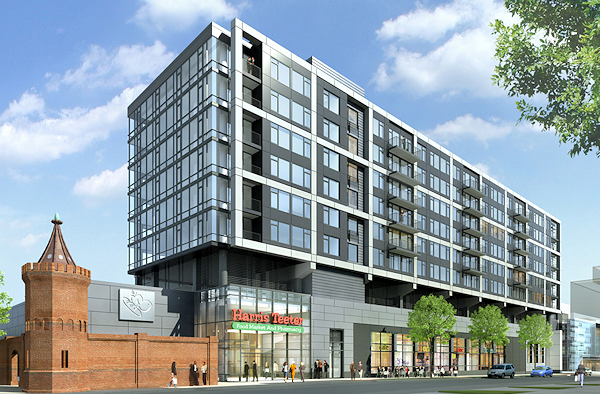
But sometimes the PR arms of companies can't help themselves--especially in the Twitterverse--and get a little ahead of the game. At which point (as the Post's Jonathan O'Connell then commented) it's pretty hard to put the toothpaste back in the tube.So, if you're wanting to know what fitness company will be coming to the retail space at 4th and Tingey (in the same residential/retail development as the Harris Teeter), it's not confirmed to be Vida Fitness. Yet.
|
Comments (2)
|
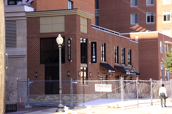
Lot 38 Espresso, the new coffee bar in the old Little Red Building/Star Market location on the northwest corner of 2nd and L SE, will at last be opening its doors this week. The owner tells me that the Grand Opening will be on Wednesday, Dec. 21, but that they will also be serving free coffee on Tuesday, Dec. 20, from 11 am to 6 pm.
Leave your impressions in the comments....
|
Comments (8)
More posts:
Little Red Bldg/Lot 38 Espresso, Retail
|
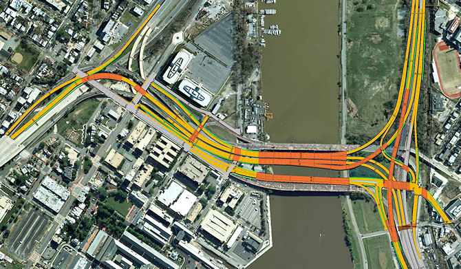 The District Department of Transportation will be hitting a big milestone in the $300 million, four-year project to build three new 11th Street Bridge spans, as the new inbound "freeway" span will be opening by Monday morning, Dec. 19.
 Mayor Gray will be participating in a ribbon cutting ceremony on the new span Friday morning, then there will be a weekend's worth of lane closures on I-295 and associated roads as the switch takes place, but DDOT expects to have traffic running on this new span by Monday's morning rush hour.
The new outbound freeway span is "tentatively" scheduled to open next week (Merry Christmas, commuters!).
There are still numerous flyovers and ramps that will need to be completed in order to add the highly anticipated new movements between the bridges and the Southeast Freeway and I-295, but that work can't be completed until traffic is moved to these two new spans.
 The separate "11th Street Local Bridge" that will connect downtown Anacostia with 11th Street by the Navy Yard (and will include pedestrian/bicycling pathways) will open probably next summer. The entire project is expected to be completed by the end of 2013.
For far more information, check my 11th Street Bridges page and DDOT's official project page. You can also see the photos I took back on Nov. 1 of the progress on all three spans.
And here's the information on this weekend's road closures and detours in advance of the lane switches, which hopefully will also be posted on DDOT's web site soon:
· A single lane will be closed on northbound I-295 between Howard Road, SE and 11th Street from 12 am to 10 pm on Saturday, December 17.
· All I-295 northbound lanes between Howard Road, SE and 11th Street, SE will be closed at 10 pm on Saturday, December 17 through 9 am the following morning.
· The ramps from northbound I-295 (Exit 4) and 13th Street, SE to the existing 11th Street inbound bridge (Exit 4) will be closed from 9 am to 5 pm on Sunday, December 18.
· The ramp from the existing 11th Street inbound bridge to the westbound Southeast/Southwest Freeway will be closed at 10 pm on Saturday, December 17 through 5 pm the following day.
· Starting at 9:00 am on Sunday, December 18 one northbound lane on I-295 will be reopened to traffic and starting at 11 am a second northbound lane will also be reopened to traffic.
During the lane and ramp closures, signed detours will be posted.
Detours:
· During the closure of the northbound lanes of I-295, motorists traveling on northbound I-295 will be detoured via the ramp from northbound I-295 (Exit 4) to the existing 11th Street inbound bridge and M Street, SE to access the eastbound Southeast/Southwest Freeway using the 9th Street, SE entrance ramp. From eastbound Southeast/Southwest Freeway, motorists will access northbound DC 295 via eastbound Pennsylvania Avenue, SE.
· During the closure of the ramps from northbound I-295 and 13th Street, SE to the existing 11th Street inbound bridge (Exit 4), motorists will be detoured onto South Capitol Street to access the westbound Southeast/Southwest Freeway, Interstate 395, and destinations located via M Street, SE.
UPDATE, 12/19: At 11:38 am on Sunday, Dec. 18, the inbound span opened. Here's coverage from NBC4, and DDOT's own blog. And in all of this I should have mentioned that this opening included the new ramp down to M Street, bypassing the old 12th Street ramp/approach to M. There's now a new light at M for the two lanes of freeway-exiting traffic to turn left.
|
Comments (8)
More posts:
11th Street Bridges
|
Tidbitiest of tidbits:
* Don't panic on Wednesday (Dec. 14) if you see what appears to be all heck breaking loose at Nationals Park--the DC Fire Department and the US Marine Corps' Chemical Biological Incident Response Force will be holding a "large-scale disaster preparedness exercise . . . simulating the joint response to a major terrorist attack." Alas, though, it won't be zombies, but rather a chemical attack. It will run from 10 am to about 2 pm. (Not open to the public.)
* DDOT and CSX have extended the comment period for the Virginia Avenue Tunnel concept offerings by 30 days, to January 30, 2012.
* Jonathan O'Connell of the Post wrote a summary of the goings-on at the Yards, none of which will be news to JDLand readers, but which might still be of interest. (The "office building with retail space" mentioned at the end is apparently the Lumber Shed, which probably would be better described as a retail building with some office space, especially since the office tenant will be Forest City themselves.)
|
Comments (0)
|
 I almost can't bring myself to write the words, but the owners of the Florida Rock site just south of Nationals Park have filed with the Zoning Commission for not only the previously reported plan to change the planned first phase office building to a residential one, but also to revisit parts of the site plan for the three subsequent phases. (For those of you versed in zoning speak, they are requesting to "revert Phases II, III, and IV to First Stage Approvals with modifications.")
 This is going to be a lengthy process, with hearings at the Zoning Commission, reports from the Office of Planning and others, and presentations to the ANC (starting with one this coming Monday night, Dec. 12). So I'm going to avoid getting into the weeds too much too early, and will just give some bullet points of what changes they are looking for. (You're free to read these 57 pages of the filing for more detail.)
* The new Phase 1 building, at the far east end of the site (next to Diamond Teague Park) will now be the aforementioned residential building, a nine-story U-shaped design oriented toward the river with 300-350 units and 286 below-grade parking spaces. There will still be 12,500 square feet of retail, though they are asking that 7,000 of it be "flex space" that "may alternatively be dedicated to residential amenity space" until retail gets going. There will be a private courtyard within the "U", but there will also be the open space on the buildings' east side, now dubbed Anacostia Plaza, that will be open enough to maintain open views from First Street and the stadium's Grand Staircase to the river but will also provide "passive recreation space."
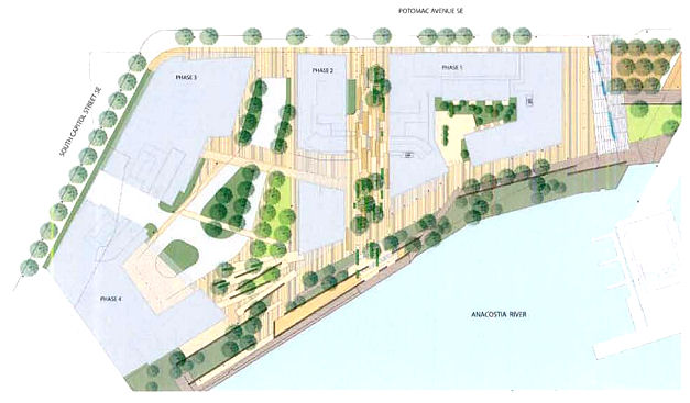 * The esplanade that has always been such a big part of the site plan remains, acting as the portion of the Anacostia Riverwalk Trail connecting South Capitol Street to Teague Park, the new pedestrian bridge, and the Yards Park. The Esplanade will "relate" to the "design vernacular" of the newly constructed boardwalks, and will also have a lot of stormwater management and bio-filtration offerings.
* On the building's west side will be the "Mews," which they call a pedestrian boulevard separating the Phase 1 building from the planned Phase 2 residential building. This path will also provide access to parking and loading for the first two phases, but "a dynamic paving design . . . will help distinguish this area as an urban space that privileges pedestrians over vehicles."
* The filing says they anticipate construction to begin in the second quarter of 2013, with first move-ins in early 2015 and the entire phase completed by summer 2015.
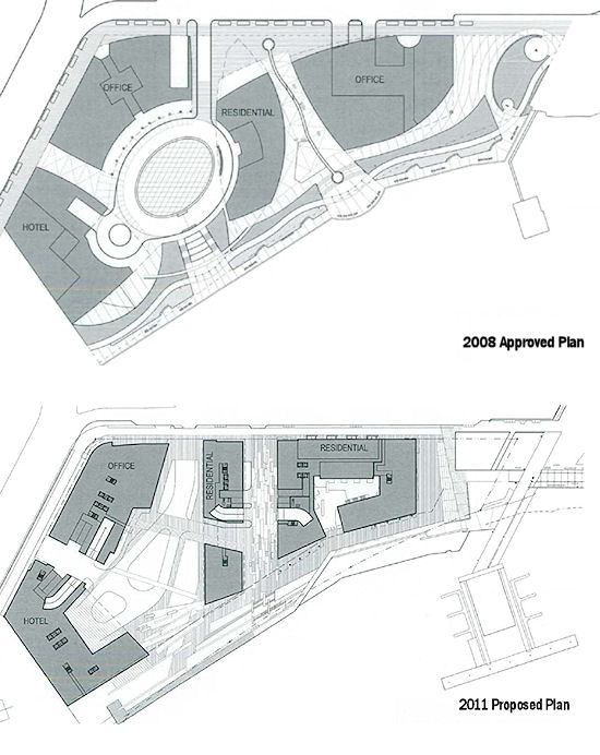
As for overall changes, here's what seem to be the most interesting changes from the previously approved design that the developers are looking for:
* The new plan would bring 1,164,640 square feet of gross floor area (4.6 FAR), up from 1,115,400 sq ft/4.4 FAR in the last plan. The other three phases' uses would remain unchanged (residential, office, hotel).
* Building heights of 130 feet for Phase 2-4 are being requested, compared to 130/112/130 last time around.
* Below-grade parking spaces would go from 1,010 to 1,144.
Plus, though It's hard to tell from one small site plan concept drawing, a lot of the public space design, especially to the east of the Phase 3 and 4 buildings, looks scaled back from the 2008 design. (UPDATE: Here's a graphic put together from another part of the filing that compares the 2008 site plan with the current one.)
The filing also says that "the Applicant would like the flexibility to provide interim uses on Phases, II, III, IV so that the site will not simply lay dormant pending construction," and lists a park, a farmers market, or other "simple, temporary retail uses" as examples.
And, just as in the previous plans, development of phases 3 and 4 are completely dependent on the construction of a new South Capitol Street Bridge, since the current bridge bisects the property where those buildings are planned.
Again, this is early in this new process, and there will be plenty of filings and presentations to come for all the additional detail you're going to be clamoring for. For now, the takeaway is that FRP/MRP want to get started on a residential building at 1st and Potomac in the spring of 2013, and still want to move forward on the rest of the site with a design similar to what was approved 3 1/2 years ago, but with some modifications.
This project first began its zoning quest in 1998, and went through a four-year process ending in 2008 to get its second-stage approvals. I should also note that Davis Buckley Architects, who worked on the project throughout that 10-year ordeal, is no longer part of the design team; SK&I is now on board, with Oculus as the landscape design firm. The site's owners, FRP Development/Florida Rock Properties, announced their partnership with MRP Realty earlier this year.
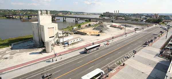
(As for the concrete plant currently on site, I haven't looked lately, but demolition is underway, and the filing says it should be done by the end of the year. Tom Boswell's heart will be broken.)
UPDATE, 1/3: Just before Christmas, demolition was finished on the plant, making it #166 in my Demolished Buildings Gallery.
|
Comments (3)
More posts:
Florida Rock, zoning
|
The agenda for Monday's ANC 6D December meeting is now available (and actually posted on their web site, too!). My hopes for a pre-holiday pass from this have been dashed, though, since there are a number of Near Southeast items on the agenda:
* There is an application pending for landmark designation for the historic 1905 DC Water Main Pumping Station, to which I'm sure we all say, "What do you mean it isn't already designated?"
* CSX will give an update on the Virginia Avenue Tunnel NEPA process. (Or you can just read my summary of last week's public scoping meeting.)
* The new partners in the RiverFront/Florida Rock project will be giving a presentation on their new zoning filing, which I'll be writing more on shortly.
* There's also going to be an update(?) on the long-desired Maine Avenue/M Street comprehensive traffic study, which we haven't heard much about in a while.
You can check the agenda for the other items. (it's a pretty long lineup. Yay. As always, December seems to be the ZOMG WE HAVE TO DO SOMETHING portion of the year, not just for ANCs but throughout the development/bureaucratic sphere.) The meeting is at 7 pm in the DCRA offices on the 2nd floor of 1100 4th St., SW.
|
Comments (0)
More posts:
ANC News, CSX/Virginia Ave. Tunnel, Florida Rock, meetings, preservation, Traffic Issues, DC Water (WASA)
|
* There was a "Wait, what?" moment on Tuesday when DCist reported that a velodrome would be coming in 2012 "in the shadow of Nationals Park in Southeast DC." I did some quick sleuthing, looking at the organization's web site and seeing Akridge as a partner, but I just couldn't place the design as being along Half Street. Then, thinking about how people so often can't get Southeast and Southwest straight when it comes to anything near the ballpark, I took a look at the Google Maps view of Akridge's Buzzard Point land at 1st and V SW, and Ta-Da! A pretty clear match.
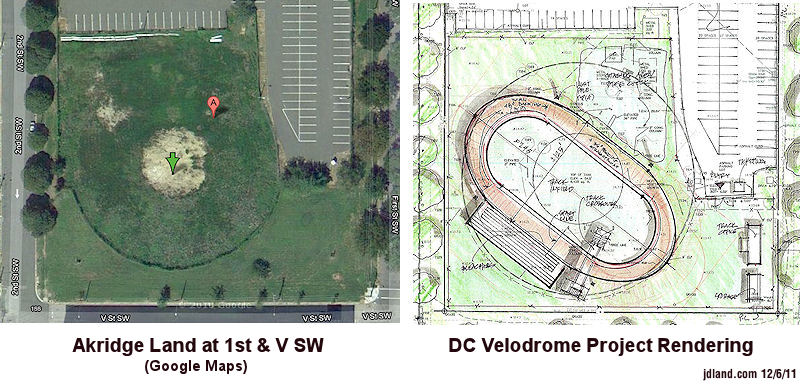
But this morning, Akridge is no longer listed as a partner on the web site, and the site rendering is gone, too. Perhaps this is all just because final leases and paperwork hadn't quite yet been signed. (A not uncommon tale, young upstarts getting all excited about a pending deal and blabbing just a little too much info for the comfort of the big company they're dealing with. Though it doesn't necessarily mean the deal is dead.) Of course, this is all actually outside my territory, so you'll want to go to SWill for updates.
UPDATE: Jonathan O'Connell has tweeted this out: "Akridge spokeswoman on velodrome: 'We don't have an agreement.' And: 'I would say that putting Akridge on the site was probably premature'."
* Last Wednesday, DDOT installed the new Bikeshare station at 3rd & G, SE, on the north side of the Results parking lot. This is technically outside of Near Southeast, but it's probably now the closest station for Capitol Quarter folks (and me!). It has 19 docks.
* DDOT is shooting for the weekend of Dec. 16 to open the new inbound/outbound freeway spans of the 11th Street Bridges, and they tormented me with some helicopter shots of the current progress. (Though remember that it's just the spans opening--they still have work to do on the ramps and flyovers to add the new movements to and from DC-295.) They also tweeted that the 11th Street Local bridge is ahead of schedule and will open spring/summer of next year. My construction progress photos from Nov. 1 are a smidge out of date by now, but still worth looking at.
* Foundry Lofts now has 19 moved-in residents.
(Of course, you already know much of this if you follow me on Twitter or Facebook.)
|
Comments (6)
|
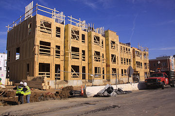
Yes, it's time for another batch of updated construction photos. This is a tough stretch of year to take these--the sun never gets very high in the sky, so anything facing due south is about impossible to get without glare. And, for places like Canal Park, it's hard to even get some locations out of the shadows long enough to get a photo that you can decipher. But you can see (below left, and on the project page) a couple of shots of the progress on the park's pavilion where the Park Tavern restaurant will be housed, along with plenty of shots vaguely showing the other ongoing ground-level work. Meanwhile, at Capitol Quarter (below right), they continue to just zip right along, with framing now well underway on the north side of L and around up 4th, and prep work for foundations continuing in the project's final block, on the south side of L.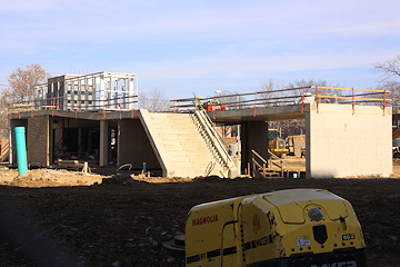

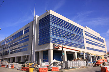
In the Renovation/Rehabilitation portion of the tour, we have a few updated images of the Boilermaker Shops (above left), another building that's tough to shoot in winter, even more so when there's not much of it other than steel beams at the moment (though they have recently been painted white). Meanwhile, 225 Virginia/200 I is coming pretty close to the end of its exterior renovations, though work inside will continue in preparation for the arrival of three DC agencies later this year.
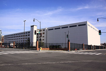
There isn't much new to see of Lot 38 Espresso (aka the Little Red Building 2.0, above left), which the grapevine says is now shooting for a mid-December opening. (But, really, at this point, it opens when it opens--the last batch of permits and approvals is always slow going, and I bet the owner wants it open even more than you do.) I also took a bunch of shots of the former National Geospatial Intelligence Agency building at 1st and M (above right), not because there's been any changes to it, but because I really enjoyed finally being able to aim a camera at it without having guards reaching for their guns. (Nyaah! Nyaah! Click! Click! Click!)
I came home with 438 new photos (yikes), and you can browse the 180-plus I decided to upload to the online archive here. (Yes, it's true, you don't actually get to see every photo I've ever taken. Which is probably for the best.)
Remember to click the  icon to see the entire range of photos for any location, while the project pages linked to above are your best bet if you're looking for paired before-and-afters and/or narrated tours.
icon to see the entire range of photos for any location, while the project pages linked to above are your best bet if you're looking for paired before-and-afters and/or narrated tours.And, in case you didn't see my tweet or my late-night update, the residential/Teeter project at 4th and M got all the dotted i's and crossed t's I mentioned in my initial post, and is officially now considered by Forest Ctiy as "commenced." (I just can't call it 1212 4th Street yet. Doesn't really make the location pop as well as "4th and M.")
 You know how I always like to say that something is expected to happen Any Minute Now? In the case of construction getting started on the southeast corner of 4th and M on the new residential/Teeter/retail building in The Yards, that's now actually a pretty true statement. On Thursday Forest City received the shoring/sheeting permit approval that the project has been waiting for, which will allow the start of digging at the site as soon as some other i's are dotted and t's are crossed.
 Also, on Monday night, with almost no discussion, the Zoning Commission approved 5-0 the project's itsy bitsy teeny weeny design modifications discussed recently.
Getting construction started Any Minute Now should allow the Harris Teeter to open in late 2013 or early 2014, if all goes according to plan, though hopefully once the shovels hit the ground, we can get a more detailed timeline as to when the entire project will be finished.
LATE UPDATE: And, just like that, i's have been dotted and t's have been crossed, and Forest City tells me that this project is now considered "commenced."
|
Comments (3)
|
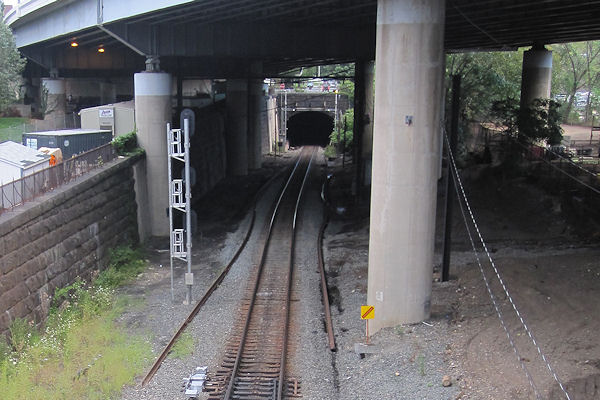 In a conference room at Nationals Park on Wednesday night, a bevy of representatives from CSX, DDOT, and FHWA along with consultants galore showed the public for the first time a series of 12 "project concepts" for how to handle CSX's desire/need to expand the capacity of the 3,800-foot-long Virginia Avenue Tunnel that runs from 2nd to 12th Street SE.
 The concepts are now posted on the project web site, and can be grouped as seven "rebuild" options along with four other "reroute" options that would bring about the abandonment of the tunnel altogether (and, it must be said, are probably a just smidge less likely to be one of the alternatives chosen).
Three of the rebuild options are along the lines of what's been discussed for more than two years now, which would be the running of a temporary track in an open trench while the expansion work is done on the existing tunnel. While having the trench on the south side of the tracks (Concept 2) has been the "default" discussion and has to be assumed to be CSX's preferred choice, Concept 3 shows the possibility of running the trench on the north side of the tunnel, which would be right next to the Southeast Freeway (and which I'm imagining would run into some issues with having to make sure all freeway supports are adequately protected). Concept 4 runs a "serpentine" trench both north and south of the existing tracks.


Concept 5 is an intriguing new notion, where a second permanent tunnel would be built parallel and south of the existing one. There's also the idea of just widening the current tunnel either while trains continue to use the tunnel (Concept 6) or with freight traffic temporarily rerouted either to Union Station (Concept 7A) or outside the District entirely (with a route shown that would take trains from Richmond through Ohio and up to Buffalo before turning back to the East Coast).
 The "reroute" options all propose abandoning the tunnel, either building a nine-mile-long freight tunnel from National Airport to the Deanwood Metro station about 80 feet underground (Concept 8) or building other alignments proposed in recent years by the National Capital Planning Commission (Concepts 9 and 10), or running on CSX's existing tracks out to Ohio and then northward.
But of course, these are concepts, and one of the reasons for going through a NEPA process is to study the different ideas to then come up with alternatives, accompanied by scads of data on noise, vibration, pollution, traffic, and timeline impacts. And to determine how much the various alternatives would cost--because it's likely that CSX is not going to be too gung-ho on the options anticipated to run into the billions of dollars.
It's expected that the public meeting where the alternatives will be unveiled will be in February of 2012, at which point so many of the questions that residents have been asking for so long about how the tunnel construction will affect the day-to-day lives of people who live near and use Virginia Avenue will get some concrete answers.
Faisal Hameed of DDOT, who ran much of the meeting, emphasized a number of times during the Q&A that this is a unique project: a private company is doing work they are paying for themselves on a right of way that they own some (but not all) of, but the impacts on vehicle/pedestrian/bicycle transportation are expected to be extensive enough that DDOT requested this environmental assessment before getting to the point of signing off on any permits that CSX will need to do the work. (There is also apparently still some negotiating going on between CSX and DDOT about exactly whose right of way is where, but it was said that no portion of the project will enter private land, though some small incursions will happen on the Marine bachelor enlisted quarters' site west of 7th Street.)
The Q&A was a pretty peaceful one as these things go (which makes a cranky blogger so very happy!). Most of the wrangling between audience members and CSX was over the route that hazardous materials take when they are forced to go around the District because of various city laws and federal regulations; the audience members were trying to get CSX to admit that there's an existing route bypassing the city that's shorter than anything shown in the concepts, while CSX wasn't going to get anywhere near telling people where hazardous materials travel.
In response to one audience question (coming as a result of the new FAQ posted on the project web site), CSX did say that they are going to "strongly pursue" getting a waiver to stop the currently required blowing of horns anytime a train enters the tunnel, and that they think it should be a "strong possibility" that it can happen, though of course they weren't wanting to commit.
There were also questions that will be better asked when the alternatives are unveiled, about construction staging, safety during construction, noise and vibration impacts, traffic flow, emergency planning, alley access, and what CSX will do to restore or even improve the Virginia Avenue streetscape when construction is finished. (As for any historic preservation impacts, a Section 106 review of the project is being done concurrently with this NEPA assessment.)
Comments are being accepted on these 12 concepts for the next 30 days, either by using the web site or e-mailing contact@virginiaavenuetunnel.com. (About 530 comments were received after the September scoping meeting.) It's hoped the environmental assessment will be completed with a final NEPA decision by the summer of 2012; though, if there is a finding that there will be a "significant environmental impact" from whichever construction alternative is chosen, then a full Environmental Impact Study (EIS) would then have to be done.
|
Comments (4)
More posts:
CSX/Virginia Ave. Tunnel, meetings
|
Today the council's Subcommittee on Redistricting is holding a hearing (watch live!) on the proposals for new ANC and single-member district boundaries. Late on Monday night, proposed maps for all eight wards were posted, with the Ward 6 maps being exactly the ones that the Ward 6 Task Force submitted back in September. However, a Twitter discussion with Tommy Wells's chief of staff has indicated that the task force maps are not what Tommy forwarded to the subcommittee, and Charles Allen was nice enough to pass along the ANC 6D portion of Tommy's map, seen below on the left, alongside the task force's recommended map (both can be clicked to enlarge):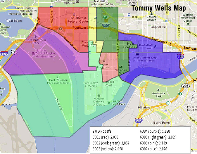
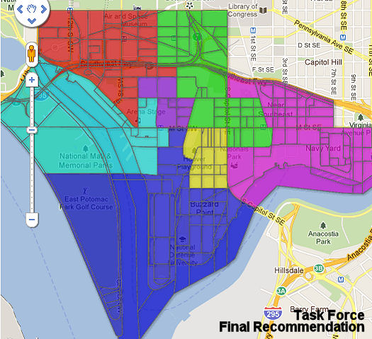


(The colors don't match up, so beware.) The two biggest differences for Near Southeast are that 1) 6D02 stretches all the way down to Nationals Park as part of its cross-South Capitol boundary, and 2) a pretty obvious notch has been drawn that happens to allow current 6D07 commissioner David Garber to remain within the SMD covering the vast majority of Near Southeast. (The populations of the block where Garber lives and the Capitol Hill Tower block are nearly identical, so a New Jersey Avenue boundary would have been easy enough to use, except that then Garber would be in an SMD with another sitting commissioner--and also wouldn't get to rule over more than about 15 blocks of Near Southeast.)
We'll see what transpires at the hearing. Watch for updates here and on Twitter. And now the Ward 6 Task Force has posted all of Tommy's maps for 6D. (You can also read my many previous posts on the SMD redistricting process over the past few months.)
|
Comments (1)
|
Jonathan O'Connell has a piece in Monday's WaPo Capital Business about Artomatic's search for a 2012 home, and how the organization wants to replicate the success of the 2009 version at the then-vacant 55 M St., SE: "This year's search is down to about four buildings, two near Nationals Park: 1015 Half St. SE, an empty 414,000-square-foot building being purchased by Prudential Real Estate Investors; and the former offices of the National Geospatial Intelligence Agency, at 101 M St. SE. Artomatic also is considering the People's Building in Northeast, and another location in Crystal City."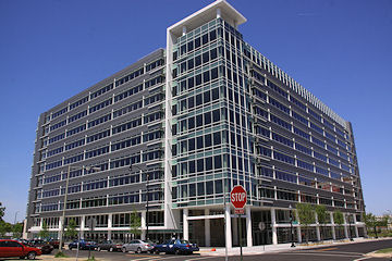
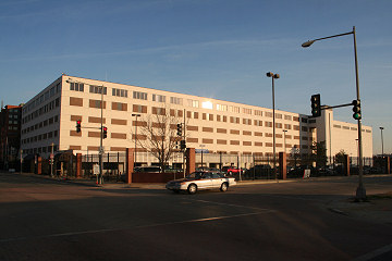
1015 Half Street (left), on the site of the old Nation nightclub, is currently home to more than 400,000 square feet of Class A office space emptiness right now. The NGA recently departed 1st and M (right), and while I would love for Artomatic to come to this spot merely for the chance to finally get inside the formerly armed encampment before its inevitable demolition as The Yards moves forward, I wonder how excited the organizers would be to have a building with almost no windows, except on the top floor. (I know that 55 M's large windows and great views of Nationals Park, Near Southeast, Southwest, and north to the Capitol were a big hit with 2009 Artomatic attendees.)
It was in December 2008 that word first began to trickle out on the 2009 Artomatic location, so perhaps the decision one way or the other won't be too long in coming.
|
Comments (0)
|
There was no way I was going to let those gray, rainy photos from Tuesday's Yards Park/Teague Park connector bridge opening stand. So, give these a try instead:


|
Comments (1)
|
2730 Posts:
Go to Page: 1 | 2 | 3 | 4 | 5 | 6 | 7 | 8 | 9 | 10 ... 273
Search JDLand Blog Posts by Date or Category
Go to Page: 1 | 2 | 3 | 4 | 5 | 6 | 7 | 8 | 9 | 10 ... 273
Search JDLand Blog Posts by Date or Category