
|
| |||||||||||||||||||

|
Please note that JDLand is no longer being updated.
peek >>
Near Southeast DC Past News Items
- Full Neighborhood Development MapThere's a lot more than just the projects listed here. See the complete map of completed, underway, and proposed projects all across the neighborhood.
- What's New This YearA quick look at what's arrived or been announced since the end of the 2018 baseball season.
- Food Options, Now and Coming SoonThere's now plenty of food options in the neighborhood. Click to see what's here, and what's coming.
![-]()
- Anacostia RiverwalkA bridge between Teague and Yards Parks is part of the planned 20-mile Anacostia Riverwalk multi-use trail along the east and west banks of the Anacostia River.
![-]()
- Virginia Ave. Tunnel ExpansionConstruction underway in 2015 to expand the 106-year-old tunnel to allow for a second track and double-height cars. Expected completion 2018.
![-]()
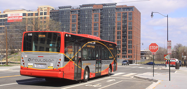
- Rail and Bus Times
Get real time data for the Navy Yard subway, Circulator, Bikeshare, and bus lines, plus additional transit information. - Rail and Bus Times
Get real time data for the Navy Yard subway, Circulator, Bikeshare, and bus lines, plus additional transit information. - Canal ParkThree-block park on the site of the old Washington Canal. Construction begun in spring 2011, opened Nov. 16, 2012.
![-]()
- Nationals Park21-acre site, 41,000-seat ballpark, construction begun May 2006, Opening Day March 30, 2008.
![-]()
- Washington Navy YardHeadquarters of the Naval District Washington, established in 1799.
![-]()
- Yards Park5.5-acre park on the banks of the Anacostia. First phase completed September 2010.
![-]()
- Van Ness Elementary SchoolDC Public School, closed in 2006, but reopening in stages beginning in 2015.
![-]()
- Agora/Whole Foods336-unit apartment building at 800 New Jersey Ave., SE. Construction begun June 2014, move-ins underway early 2018. Whole Foods expected to open in late 2018.
![-]()
- New Douglass BridgeConstruction underway in early 2018 on the replacement for the current South Capitol Street Bridge. Completion expected in 2021.
![-]()
- 1221 Van290-unit residential building with 26,000 sf retail. Underway late 2015, completed early 2018.

- NAB HQ/AvidianNew headquarters for National Association of Broadcasters, along with a 163-unit condo building. Construction underway early 2017.

- Yards/Parcel O Residential ProjectsThe Bower, a 138-unit condo building by PN Hoffman, and The Guild, a 190-unit rental building by Forest City on the southeast corner of 4th and Tingey. Underway fall 2016, delivery 2018.

- New DC Water HQA wrap-around six-story addition to the existing O Street Pumping Station. Construction underway in 2016, with completion in 2018.

- The Harlow/Square 769N AptsMixed-income rental building with 176 units, including 36 public housing units. Underway early 2017, delivery 2019.

- West Half Residential420-unit project with 65,000 sf retail. Construction underway spring 2017.
![-]()
- Novel South Capitol/2 I St.530ish-unit apartment building in two phases, on old McDonald's site. Construction underway early 2017, completed summer 2019.
![Novel South Capitol]()
- 1250 Half/Envy310 rental units at 1250, 123 condos at Envy, 60,000 square feet of retail. Underway spring 2017.
![-]()
- Parc Riverside Phase II314ish-unit residential building at 1010 Half St., SE, by Toll Bros. Construction underway summer 2017.
![-]()
- 99 M StreetA 224,000-square-foot office building by Skanska for the corner of 1st and M. Underway fall 2015, substantially complete summer 2018. Circa and an unnamed sibling restaurant announced tenants.
![-]()
- The Garrett375-unit rental building at 2nd and I with 13,000 sq ft retail. Construction underway late fall 2017.
![-]()
- Yards/The Estate Apts. and Thompson Hotel270-unit rental building and 227-room Thompson Hotel, with 20,000 sq ft retail total. Construction underway fall 2017.
![-]()
- Meridian on First275-unit residential building, by Paradigm. Construction underway early 2018.
![-]()
- The Maren/71 Potomac264-unit residential building with 12,500 sq ft retail, underway spring 2018. Phase 2 of RiverFront on the Anacostia development.
![-]()
- DC Crossing/Square 696Block bought in 2016 by Tishman Speyer, with plans for 800 apartment units and 44,000 square feet of retail in two phases. Digging underway April 2018.
![DC Crossing]()
- One Hill South Phase 2300ish-unit unnamed sibling building at South Capitol and I. Work underway summer 2018.
![One Hill South Phase 2]()
- New DDOT HQ/250 MNew headquarters for the District Department of Transportation. Underway early 2019.
![New DDOT HQ]()
- 37 L Street Condos11-story, 74-unit condo building west of Half St. Underway early 2019.
![37 L Condos]()
- CSX East Residential/Hotel225ish-unit AC Marriott and two residential buildings planned. Digging underway late summer 2019.
![CSX East Residential/Hotel]()
- 1000 South Capitol Residential224-unit apartment building by Lerner. Underway fall 2019.
![1000 South Capitol Residential]()
- Capper Seniors 2.0Reconstruction of the 160-unit building for low-income seniors that was destroyed by fire in 2018.
![1000 South Capitol Residential]()
- Chemonics HQNew 285,000-sq-ft office building with 14,000 sq ft of retail. Expected delivery 2021.
![1000 South Capitol Residential]()


2682 Blog Posts Since 2003
Go to Page: 1 | ... 5 | 6 | 7 | 8 | 9 | 10 | 11 | 12 | 13 ... 269
Search JDLand Blog Posts by Date or Category
Go to Page: 1 | ... 5 | 6 | 7 | 8 | 9 | 10 | 11 | 12 | 13 ... 269
Search JDLand Blog Posts by Date or Category
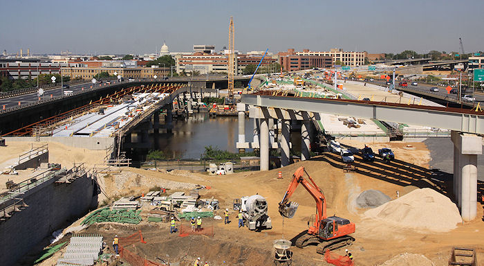 On Friday morning I was lucky enough to get a wonderfully wide-ranging tour of the 11th Street Bridges project, and of course made sure to have camera in hand to get a pile of photos of the current state of construction. I've put together a gallery of these photos, and will slowly work on adding them to my 11th Street Bridges project page over the next week or so. Some points of note:
* DDOT expects that the new bridges carrying inbound and outbound freeway traffic will open by the end of this year. There will still be plenty of work to do in terms of ramps and connections and other necessary work surrounding those bridges, but at least these new structures will be open fairly soon. (If you haven't been following closely, one of the big "adds" of this entire project is that when completed vehicles will be able to move between the freeway bridges and northbound/southbound DC295 in all directions, which isn't currently the case.)
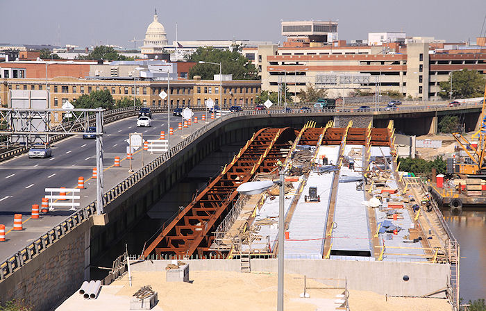 * The new 11th Street Local bridge, carrying traffic between Anacostia and 11th Street SE by the Navy Yard, is expected to open by fall of next year. However, according to Greater Greater Washington and other outlets, this bridge apparently will not be having streetcar tracks built into it during this initial construction phase as originally designed, because of all manner of bureaucratic falderal I'm too lazy to bother trying to explain here. If this happens, portions of the deck of the bridge would have to be pulled up and redone with the streetcar tracks a few years from now. (On the other hand, the concrete hasn't been poured on this bridge yet, so maybe there's still a chance some folks could figure out a way to get it to happen now?)
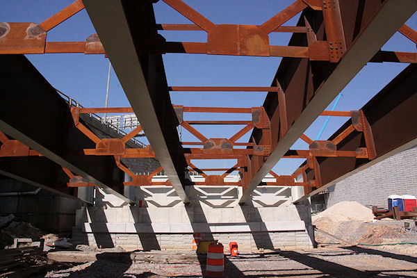 * These graphics show the plans for the paths and landscaping under the bridges along the Anacostia Riverwalk Trail (just east of the entrance to the Navy Yard's portion of the riverwalk). They appear to include an interesting little jut-out into the river, on what I imagine is the footprint of the existing downstream bridge.
* If you drive 11th Street north of M and see the big concrete piers popping up to the east, they are for the new flyover ramp that will connect inbound freeway bridge traffic to the Southeast Freeway. Work is also underway on a new ramp that will bring traffic from RFK and Pennsylvania Avenue up to a signalized interchange at 11th Street rather than continuing underneath 11th to the Southeast Freeway. There will then be a ramp from 11th to the westbound freeway, which means that folks who live on the eastern side of Capitol Hill or who work at the Navy Yard will be able to get on the freeway at 11th rather than zooming down Virginia Avenue all the way to 3rd Street.
It's a pretty big project, and I'm giving short shrift to much of the change that will be coming to the connections to the bridges on the east side of the Anacostia, but the new photo gallery should still be interesting, and my 11th Street Bridges Project page can probably help with additional details if you're in need.
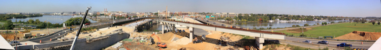
The photo gallery also has this stitched-together panorama taken up on the new flyover bridge, but you'll probably want to look at a larger version, since it gives a pretty good look at a large swath of skyline alongside the Anacostia River:
If you missed my batch of photos from last week of the new Southbound 295 flyover bridge that opened over the weekend, here they are.
|
Comments (5)
More posts:
11th Street Bridges
|
Late tonight, DDOT will be opening the new southbound DC 295 flyover bridge, which is the first major phase of completed work on the 11th Street Bridges project. This will shift the flow of southbound traffic so that vehicles merging into 295 from the outbound 11th Street Bridge will be funneled into the left side of the freeway traffic, allowing thru 295 traffic to much more easily access the Howard Road exit without having to weave through the 11th Street Bridge merge flow.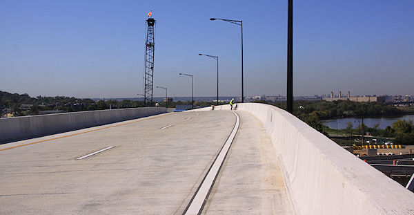 Since this is on the east side of the Anacostia, it's not something I'd normally be writing much about, except that I got to visit the flyover bridge with camera in hand, hours before its opening, as part of a wide-ranging tour of the entire 11th Street Bridges project that DDOT was generous enough to arrange for me. In order to stay ahead of the news cycle, I've posted a quick gallery of images of the new flyover bridge,
Since this is on the east side of the Anacostia, it's not something I'd normally be writing much about, except that I got to visit the flyover bridge with camera in hand, hours before its opening, as part of a wide-ranging tour of the entire 11th Street Bridges project that DDOT was generous enough to arrange for me. In order to stay ahead of the news cycle, I've posted a quick gallery of images of the new flyover bridge, But of course these are not the only photos I took, and so early next week look for another batch of images that I'll be posting of the work on the bridges themselves and the new approaches that are being put in place. Work began on the project in late 2009, and DDOT expects that the new inbound and outbound freeway bridges will be open by the end of this year. The new 11th Street Local bridge should open in the second half of next year, with the various new connector ramps being completed soon after. (There is one shot of the new bridges included in this batch that should whet your appetite.)
|
Comments (0)
More posts:
11th Street Bridges
|
The DC approved building permits feed, now back online (thank you!), brings the news today that the raze permit filed in February for the concrete plant on the Florida Rock site across from Nationals Park has now been approved. With the move of the operations around the corner down South Capitol Street to Buzzard Point finished, demolition should be able to get underway fairly soon. (Though whether it actually WILL....)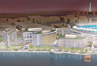 As we found out a few months ago, site owner Florida Rock Properties has entered into a joint venture with MidAtlantic Realty Partners to move forward on the first phase of the 1.1-million-square-foot "RiverFront on the Anacostia" redevelopment of the site, which they are hoping will be a 200-unit apartment building on the eastern edge of the site (across from the Nationals Park grand staircase at First and Potomac, next to Diamond Teague Park) instead of the office building originally planned. The Zoning Commission will need to approve this change, and that process should be beginning soon. Apparently there will be a presentation on the new plans at the Oct. 17 ANC 6D meeting (though the agenda isn't out yet). Their hope is to begin construction in the spring of 2013.
As we found out a few months ago, site owner Florida Rock Properties has entered into a joint venture with MidAtlantic Realty Partners to move forward on the first phase of the 1.1-million-square-foot "RiverFront on the Anacostia" redevelopment of the site, which they are hoping will be a 200-unit apartment building on the eastern edge of the site (across from the Nationals Park grand staircase at First and Potomac, next to Diamond Teague Park) instead of the office building originally planned. The Zoning Commission will need to approve this change, and that process should be beginning soon. Apparently there will be a presentation on the new plans at the Oct. 17 ANC 6D meeting (though the agenda isn't out yet). Their hope is to begin construction in the spring of 2013.|
Comments (1)
|
Greater Greater Washington reports that DDOT has formally asked WMATA for four Metro station name changes, with "Navy Yard-Ballpark" being on the list. This seems to put to an end the attempt by the Nationals to add their Curly W to the station name, an idea which was supported by ANC 6D last month. (The BID's desire to have the station renamed "Capitol Riverfront-[Curly W]" also now would appear to have gone by the wayside.)
Also on the list is changing Waterfront-SEU to Waterfront-Arena Stage.
This is the last step in the city's process for requesting station name changes. Now it's up to WMATA to make the final decisions.
|
Comments (0)
More posts:
Metro/WMATA
|
Just sent out by DDOT: "Today the District Department of Transportation (DDOT) announced the start of land acquisition and preliminary design work for the South Capitol Street Project, which includes replacement of the current Frederick Douglass Memorial Bridge. [...] While the Record of Decision (ROD) is still pending, the Federal Highway Administration signed the project's Final Environmental Impact Statement (FEIS) following the requisite 30-day public comment period that ended in May."
I'm posting quickly, so I shall now crib unabashedly from my post on the Final EIS, from back in April:
If you are interested in this subject, there is more verbiage and documentation accompanying the plans than you could ever dream of. (Traffic studies! Environmental consequences! Technical reports!) And I've written a lot about the process, which began more than a decade ago with other studies before the EIS got underway. And I'm sure there will be posts on other blogs delving more specifically into portions of the plans. But, since most people probably want to know "what does this mean for me?", you can see this graphic (from the 224-MB chapter 2 of the FEIS) giving a quick overview of what changes are planned along South Capitol Street if the final EIS is signed off on (and, more importantly, if funding is secured). The short version, for the west side of the Anacostia:
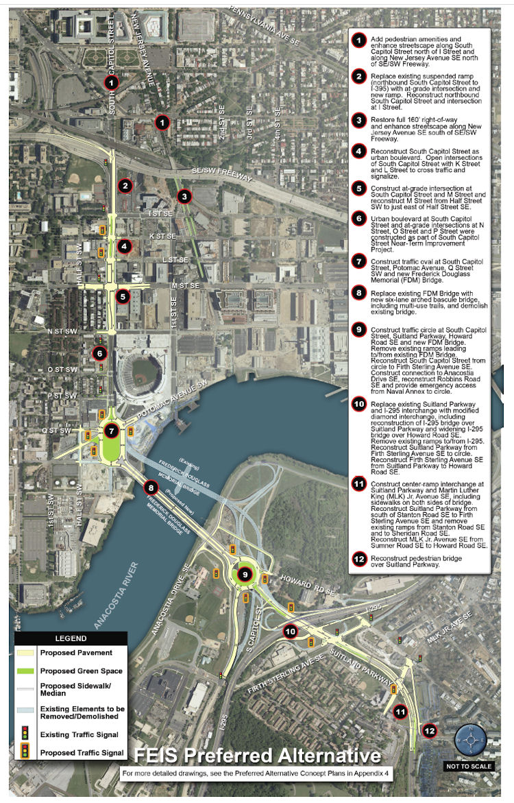 * Add "pedestrian amenities" and enhance the streetcape along South Capitol north of I and along New Jersey Avenue SE north of the freeway.
* Add "pedestrian amenities" and enhance the streetcape along South Capitol north of I and along New Jersey Avenue SE north of the freeway.
* Replace the existing ramp to the freeway from South Capitol and I with an at-grade intersection. (This would be a left turn onto a ramp to the freeway from under the freeway, near the current Nats HH economy parking lot.)
* Bring New Jersey Avenue SE back to a 160-foot full right-of-way, and add streetscape enhancements.
* "Reconstruct South Capitol Street as an urban boulevard." This means bringing M Street up to an "at-grade" intersection (no more tunnel), and would include new signalized at-grade intersections to allow traffic to cross South Capitol on K and L streets. (M Street would also get reconstructed between the Halfs [SE and SW].) The section of South Capitol north of M would have the same streetscape that the south portion received during its 2007/08 makeover, with wide sidewalks and a tree-lined median.
* Build a traffic oval at South Capitol, Potomac, Q, as the gateway to a new arched bascule-design Douglass Bridge that would have wide "multi-use trails" (i.e., sidewalks!) in both directions. The existing bridge would be demolished, after the new bridge is built somewhat downriver of the current location.
The Executive Summary (220 MB PDF) gives a good overview of the FEIS and preferred alternative (as it should!), but I also suggest wandering through the Chapter 2: Alternatives section, especially if you came to the neighborhood or JDLand after 2008 and didn't get to follow along during the EIS process, or if you're interested in the additional plans for east of the river, which I'm going to leave to others to discuss. My previous posts on all of this may be of interest as well. If you're wanting to see some of the earlier studies referenced in the FEIS, there are links to them at the top of my South Capitol Street project page.
How much would this all cost? The preferred alternative is priced in this final EIS at $806 million in FY 2014 dollars. (New bridges are expensive, you know.) Note that nothing in today's statement from DDOT says anything about funding, or a construction timeline.
You can also check my South Capitol Street and South Capitol Street Bridge page for all the info about the plans, along with my scores of posts over the past few years.
|
Comments (6)
|
 * On October 3, the following changes will be made to the Navy Yard-Union Station Circulator route: "[B]uses will no longer travel west on Constitution Avenue and north on Louisiana Avenue to reach Union Station. Buses will instead stop adjacent to Union Station on Columbus Circle at the flag poles before turning right on F Street, NE and right on 2nd Street, NE to Constitution Avenue. The route will no longer serve the Union Station garage level and the stops located at Louisiana and D Streets, NE will no longer be served." Other Circulator changes--including the end of the SW-Convention Center route and the beginning of an east-of-the-river route that will run down Barracks Row--are listed here.
* DDOT and the Washington Area Bicyclist Association (WABA), along with ANC commissioner David Garber, have launched "Rack Attack," which will result in the installation of 36 new bike racks around Near Southeast. The first one was installed this morning at Cornercopia.
|
Comments (3)
More posts:
Pedestrian/Cycling Issues, circulator
|
At the Ward 6 Redistricting Task Force's meeting on Sept. 22, final recommendations for ANC and SMD boundaries were approved, and the 6D map they are recommending remains close to their original draft proposal, despite 6D's request for substantial changes.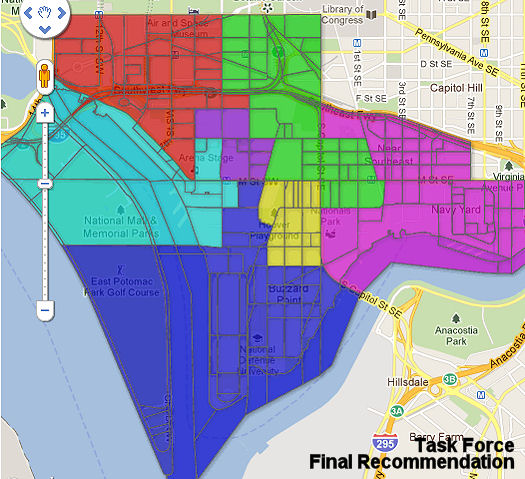
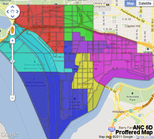
I'm not going to talk about the changes in western Southwest, but you can see on the two maps below the large differences close to and east of South Capitol Street between what the task force is recommending (left) and what the ANC wanted (right) (click to enlarge):
(Task Force final recommendation on left, ANC proposal on right. 6D02 is green, 6D03 purple, 6D07 fuschia)
The task force's original recommendation in August (very similar to the map above left) was for 6D02 to come across South Capitol Street into Southeast, covering the area bounded by I, New Jersey, and N. Then 6D07 would cover the rest of Near Southeast (except for the small cut-out on the northeastern side, which has been and will continue to be in ANC 6B). This would mean that 6D07/Near Southeast commissioner David Garber's current address would no longer be in 6D07 but instead in 6D02, where commissioner Cara Shockley also still resides under the new boundaries.
This, with a number of other changes that the 6D commissioners disapproved of, moved them to proffer their own map (above right), which kept 6D02 all in Southwest and instead expanded chair Ron McBee's 6D03 SMD across South Capitol, in such a way that Garber's block would remain in 6D07. (It also had 6D07 coming west across South Capitol for one small block, bounded by South Capitol, M, Carrollsburg, and N.) Cara Shockley vehemently disapproved of this map at the commission's September meeting, while Garber did not vote on it (citing what he described as his constituents' desire to be instead be a part of ANC 6B).
I was not at the task force's Sept. 22 meeting, but the ANC's arguments do not appear to have held much sway, and the final 6D map being recommended by the task force (above left) is very similar to the original draft map, at least in terms of how it handles blocks east of South Capitol.
The task force will be meeting again on Monday, Sept. 26 at 6:30 pm at 1100 4th St. SW (DCRA hearing room) to approve the report that will "include the narrative to explain the recommendations as well as the required text description of the ANC/SMD boundaries." That report and the maps will then be submitted to Tommy Wells on Sept. 28, who will then submit Ward 6 redistricting recommendations to the council on Sept. 30.
UPDATE: Guess it wouldn't hurt to include a link to the current 6D SMD boundaries.
|
Comments (6)
More posts:
ANC News, redistricting
|
Readers are reporting that late Saturday night three or four shots were fired on the Southeast Freeway that resulted in a bullet going through a window of one of the houses in the 300 block of Virginia Ave. SE, with the one of the bullet's shards then ending up either lodged in or very near the bassinet of a 5-day-old baby. No one in the house was injured. The gunfire seems to have been the result of people in one car on the freeway shooting at another car.
There's no police report anywhere as yet, so these are only details I'm getting from readers, but perhaps more information will become available. (I've sent a request into the MPD 1D mailing list.)
UPDATE: This is Commander Hickson's reply to my question on the MPD-1D list: "There was a shooting on the Freeway that involved a passenger in one moving vehicle firing at another moving vehicle. As a result of that shooting a shot struck and entered a private premise in the 300 block of VA Ave SE, causing damage to the home and the targeted vehicle. Thankfully, no one was injured in the vehicle or the home. The only description that was provided was for a black "luxury" vehicle, occupied by three subjects."
UPDATE II: Here's WJLA's story on the episode (though goodness, it needs a copy editor desperately). And Fox5's.
|
Comments (1)
|
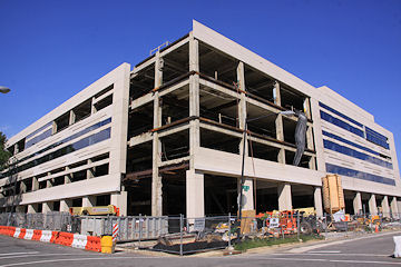
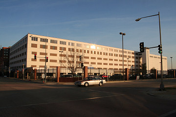 A little birdie tells me that the National Geospatial Intelligence Agency folks are having a "site closure ceremony" sometime next week for their operations on the southeast corner of 1st and M, SE. (You know, the place with hardly any windows and the guys out front with guns.) As part of the Base Realignment and Closure (BRAC) process, their operations have moved to swank new digs down at Ft. Belvoir.
The closure ceremony is apparently for "cleared personnel only."
This site, officially known as Building 213 from the old Navy Yard/Southeast Federal Center days, is on the footprint of the Yards and as expected to be home to an office building someday, but not anytime soon.
In the meantime, maybe that parking lot will become available to the public?
|
Comments (3)
More posts:
The Yards, Parcel A/Yards
|
If you're looking for things to do this weekend beyond the final Nats home games of the season and Blocktoberfest, you've got choices just across the freeway and just across South Capitol Street:
* The inaugural SW ArtsFest runs Friday through Sunday, featuring the (e)merge art fair at the Capitol Skyline Hotel and a series of other artsy events around the neighborhood. See their Facebook page for all the details. (The Post has some info on (e)merge as well.)
* The Barracks Row Fall Festival is on Saturday from 11 am to 5 pm, transforming 8th Street SE between E and I into "a midway full of music, food, and favorite local traditions."
On the calendar for the rest of the week:
* Thursday, Sept. 22 brings both the Capital Bikeshare 1st Birthday Bash at the Yards Park and this year's Opera in the Outfield at Nats Park. Bikeshare's bash runs from 6 to 9 pm; Opera starts at 7:30 pm.
* The Nats play their final home games of the 2011 season against the Braves this weekend, and the team is promoting it as a FAN-tastic FAN-ale. There will be fireworks after Friday night's game (and perhaps during the game, since Strasburg is scheduled to be on the mound). Saturday and Sunday, both afternoon games, have limited $2 tickets available along with food and drink specials and giveaways. Details here.
* And on Saturday the 24th the Yards Park is hosting Blocktoberfest, with multiple stages, more than 10 acts, food, and of course beer. There were complaints from residents about noise levels during a 10-hour event at the park on Sunday the 18th; one reply from the BID to a resident in the aftermath says that they "have learned a valuable lesson about events in the Park and the noise level," and that they are evaluating the types of events that are appropriate rental use for the park.
What will I be doing for the next few days? Praying that my beloved Google Nexus One phone comes back to life after an overnight seltzer soaking (thanks, cat). It's in a Ziploc bag full of rice drying out as we speak....
|
Comments (1)
|
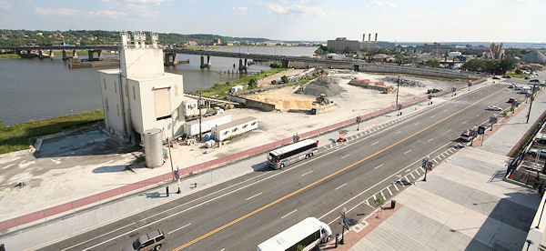 Back in March we learned that the plans were underway to move the gravel/stone/concrete operations that have been at 25 Potomac Ave. since the 1920s around the corner to South Capitol and S Street SE, down in Buzzard Point. All that needed to be done was build some new infrastructure at the new location, and get a raze permit approved, and then the site long known as Florida Rock could be demolished, which the site owners were hoping would be happen by early summer.
Of course, as is so often the case, the actual timeline didn't quite match up to expectations. Most notably, the new site had problems getting electricity, which was a mite ironic given its location within spitting distance of the huge power plant at Half and S SW. But I'm told that a temporary Certificate of Occupancy has finally been secured, and operations are starting to move from Potomac Avenue to Buzzard Point. And, once the raze permit applied for back in March is approved, demolition can begin.
Plans have been on the boards for a number of years now to transform the 5.8-acre site into the mixed-use RiverFront on the Anacostia, and in July it was announced that owners Florida Rock Properties will be partnering with MidAtlantic Realty Partners to develop the first phase of the project, an apartment building on the far eastern end of the site near Diamond Teague Park and across from the Grand Staircase at Nationals Park. This is a change from the office building originally planned for this phase, and will need to go through the Zoning Commission for approvals. It's hoped that construction could begin in spring 2013.
If you want to know more about the plans for the site, my Florida Rock/RiverFront page is chock full of renderings and details.
(Hat tip to eagle-eyed Man About Town David Garber, who noticed on Saturday afternoon that the cement tower on Potomac Avenue appeared to be losing some of its panels.)
|
Comments (1)
More posts:
Development News, Florida Rock
|
Clark Construction has delivered the new National Geospatial-Intelligence Agency campus at Ft. Belvoir, says CityBiz Real Estate.
(Not coincidentally, the federally legislated deadline for BRAC moves was yesterday.)
Has NGA finished moving out of the armed encampment at First and M, SE?
|
Comments (0)
More posts:
The Yards, Parcel A/Yards
|
Keying off my post about ANC 6D's approval of Navy Yard- as a new name for the Metro station by Nationals Park, Greater Greater Washington expressed some displeasure ("Navy Yard-W" is worst of new station name proposals"). That post was then pondered by DCist and mocked by SB Nation for, among other things, the contention that people would think "Navy Yard-W" was named for former president George W. Bush. And now there's a GGW follow-up saying that, by appending "Ballpark" to the Navy Yard station name, people won't use other stations that might work better for them to get to the stadium. (Though, really, when the Navy Yard station is all of a block away from Nats Park, maybe it's okay to label that as the station people should use.)
|
Comments (0)
More posts:
ANC News, Metro/WMATA,
|
Greater Greater Washington covers the CSX Public Scoping Meeting, focusing on how some attendees were surprised to only find informational displays and no presentations from CSX, DDOT, or FHWA. A shame no one made any mention of that in advance.
The boards from the meeting have now been posted on the official Virginia Avenue Tunnel web site. There's now a 30-day comment period, with a design concepts meeting to follow not long after. That's when the real nitty gritty should appear.
|
Comments (0)
More posts:
CSX/Virginia Ave. Tunnel,
|
The Ward 6 Redistricting Task Force blog has posted ANC 6D's formal recommendations on redistricting, approved at Monday's meeting, with the changes I laid out previously.
UPDATE: Also now posted, 6B's formal recommendations, with no mention of Near Southeast's remaining in 6D instead of moving to 6B.
|
Comments (0)
More posts:
ANC News, redistricting,
|
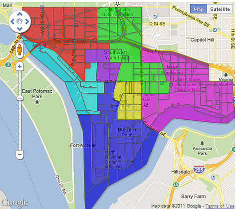
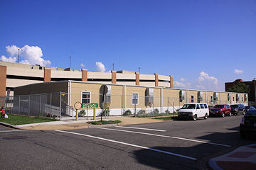
First, a reminder that Wednesday Sept. 14 brings the Public Scoping Meeting for the Virginia Avenue Tunnel project. This is a "we want to hear what YOU think!" meeting, so there will be no presentations of actual plans for the construction. It will just be an open house with information on what exists and what needs to be done, and a chance for interested parties to submit their feedback to DDOT and the FHWA. The meeting is from 6:30 to 8:30 pm at Van Ness Elementary School; you can read more about the meeting in my post from last month. There's also the official web site, and this flyer from the newly formed Concerned Citizens of Virginia Avenue that makes clear their opinion on what's to come. Additional meetings where CSX will finally provide some specifics on their designs and plans should come later this fall. 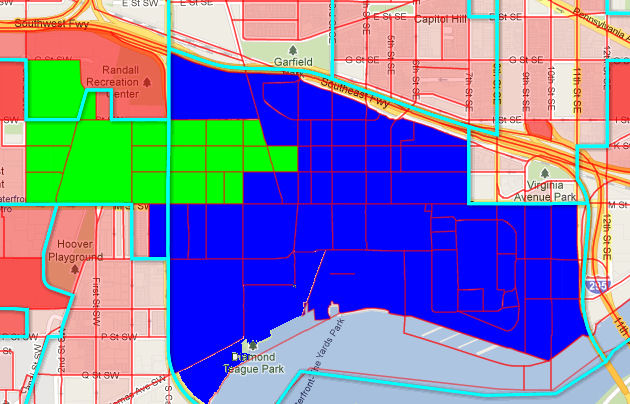 * Redistricting: The ANC proffered an alternate Single Member District map from what the Ward 6 Redistricting Task Force has proposed. It tweaks the proposed boundaries in a way that moves current commissioner David Garber's building and the 70/100 I buildings back into 6D07 (along with the small block in Southwest bordered by South Capitol, M, N, and Carrollsburg Place), while placing Capitol Hill Tower, 909 New Jersey, and Velocity in 6B03, which reaches across South Capitol from Southwest. (The proposed SMDs that cover Near Southeast are in my quickie map at right.) Commissioner Cara Shockley, whose 6D02 was altered substantially from what the task force had proposed (it would have covered the portion of Near Southeast now given to 6D03, along with 70/100 I and Onyx, but not CHT), told the commission she was completely opposed to the new boundaries, and had no idea that such a big change was being proposed by the ANC, having been unable to open the attachments with the map images. David Garber took no official position on 6D's map, saying that because his constituents have made clear that they feel Near Southeast belongs in 6B and not 6D he would not be voting. In the end, the ANC supported the resolution offering up the alternate map in a 4-1-2 vote, with Garber and Bob Craycraft abstaining and Shockley voting against.
As for doings at Monday night's ANC 6D meeting beyond the Metro station renaming items I already wrote about:
* Capper Time Extensions: The commission voted 7-0 to support the request for two-year extensions on two planned Capper apartment buildings and the office building planned for 600 M Street, which is also part of the Capper redevelopment. (I hadn't realized that 600 M was part of this request when I wrote my entry last week.) This would push the planned start dates for these three projects into the late 2013-early 2014 time frame.
As is usually the case with any Capper issue in front of the commission, Chairman McBee brought up the delayed community center, which Housing Authority representatives said should get its needed $7.4 million in funding when a new bond issuance happens later this year, and a building permit should be filed for in advance of the July 2012 deadline. As is also most always the case with Capper issues, the commission also wanted statistics and information on the former residents of the project, and whether they are being tracked and worked with. The DCHA reps said that 129 residents have returned to Capper, with another 550 on the waiting list, though some of those have turned down recently completed units for various issues (not wanting a walkup, etc.). This is with about half of the required 707 public housing units already constructed.
This extension was to have been heard by the Zoning Commission on Monday night, but since the ANC had not yet had a chance to weigh in, the applicants agreed with a request to delay action until the Zoning Commission's Sept. 26 meeting. If you want to know more, you can read my entry from last week (no need to write it all again!).
 * Redistricting: The ANC proffered an alternate Single Member District map from what the Ward 6 Redistricting Task Force has proposed. It tweaks the proposed boundaries in a way that moves current commissioner David Garber's building and the 70/100 I buildings back into 6D07 (along with the small block in Southwest bordered by South Capitol, M, N, and Carrollsburg Place), while placing Capitol Hill Tower, 909 New Jersey, and Velocity in 6B03, which reaches across South Capitol from Southwest. (The proposed SMDs that cover Near Southeast are in my quickie map at right.) Commissioner Cara Shockley, whose 6D02 was altered substantially from what the task force had proposed (it would have covered the portion of Near Southeast now given to 6D03, along with 70/100 I and Onyx, but not CHT), told the commission she was completely opposed to the new boundaries, and had no idea that such a big change was being proposed by the ANC, having been unable to open the attachments with the map images. David Garber took no official position on 6D's map, saying that because his constituents have made clear that they feel Near Southeast belongs in 6B and not 6D he would not be voting. In the end, the ANC supported the resolution offering up the alternate map in a 4-1-2 vote, with Garber and Bob Craycraft abstaining and Shockley voting against.
 The task force's next public meeting is on Sept. 19 to propose the second draft of SMD boundaries, followed by a final meeting to approve their final draft maps on Sept. 22. Tommy Wells will then submit recommendations on boundaries to the city council by Sept. 30. For more on all the redistricting process, see my previous entries.
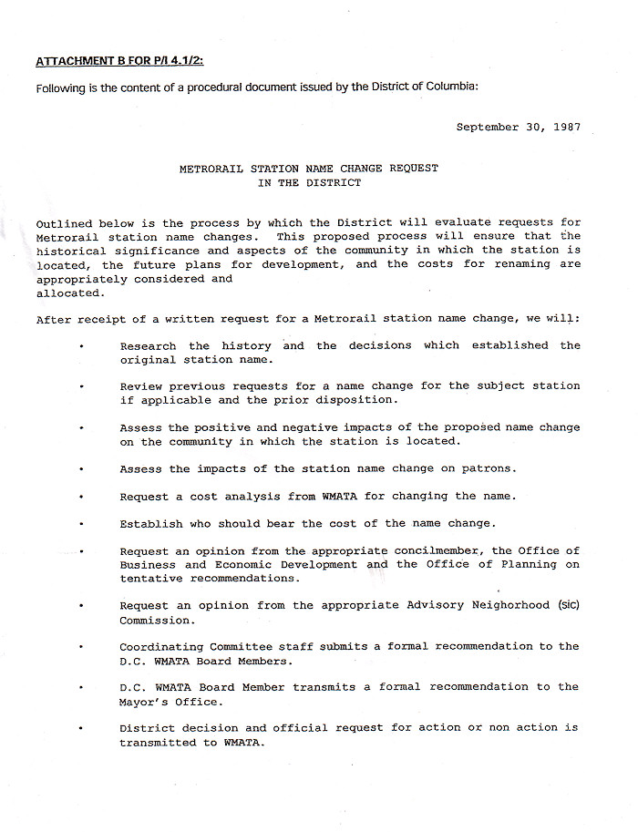
With WMATA looking to tighten up the naming conventions for Metro stations and also preparing for a new map thanks to the impending service expansion to Tysons Corner and eventually Dulles, the three local jurisdictions have been encouraged to come up with proposals by the end of this month for any station name revisions they may want. This brought Steve Strauss of DDOT to Monday's ANC 6D meeting, to find out whether the community had any feelings about the names of the four stations within the commission's borders, and in particular whether the ANC had any desire to take a second look at two proposed name changes it supported last year in light of WMATA's recommitment to the notion that station names should be no longer than 19 characters (13 for transfer stations). Last December the commission voted to support requests from both the Capitol Riverfront BID and the Nationals to change the station name to Navy Yard-Capitol Riverfront-, but that is well above 19 characters (and would be even worse if the Curly W weren't approved and "Nationals Park" were substituted, as called for in the ANC resolution at the time). The discussion on Monday night centered around whether using the logo would set a dangerous precedent, whether it would be confusing in terms of pronouncing the station name, whether it's de facto advertising, and whether riders with vision impairments would or would not be better served by having a logo versus a spelled-out "Ballpark." Commissioner Andy Litsky was also vocal in wanting some assurance that the Nationals would be paying the estimated $100,000 for the changing of the name of a station, and would not try to argue that the city should pay the cost since the stadium is a public building.
Yes, it's time for the Curly W discussion again.
Last December the commission voted to support requests from both the Capitol Riverfront BID and the Nationals to change the station name to Navy Yard-Capitol Riverfront-Gregory McCarthy of the Nationals told the commission many of the same things he did back in December: the Curly W is the official logo of a city-owned building, and the team wants the logo to appear on transit signage just as it does on freeway signs around the area. McCarthy also said the team very much wants to promote transit as the best way to get to the stadium, and that having the logo on signs and maps helps to emphasize the connection between Metro and the Nationals year-round. There's also no desire to have any variation of "Nationals Park" in the name, given the possibility that the stadium's naming rights will someday be sold and the name changed.
An initial motion to rename the station Navy Yard-Ballpark failed on a 3-3 vote; after more discussion, a new motion to support Navy Yard- if a logo were allowed, and Navy Yard-Ballpark if not, passed on a 4-2 vote. (Technically, these motions were all about amending the resolution from December, but I'm giving you the blessedly short version.)
I should also note that the Capitol Riverfront BID's recent request to simply rename the station Capitol Riverfront- was briefly mentioned at the start of the discussion, but clearly had zero support from the commission or the audience and was never voted on.
The ANC also voted 7-0 to change Waterfront-SEU to Waterfront-Arena Stage. But the resolution acknowledged that the new station name would be 22 characters long, and so a second resolution was passed on a 4-3 vote asking to rename the station as SW Waterfront if Arena Stage does not get added to the name.
There was a brief discussion as to whether there might be interest in adding Banneker Park to the L'Enfant Plaza station, but there was little support, and recognition that the name would be too long anyway.
All requests for changing station names will first go through the city's evaluation procedures, with the mayor's office then submitting formal recommendations to WMATA.
|
Comments (2)
|
I took a lot of photos on Sunday, so many that I'm not going to waste time trying to come up with some pithy introduction. What you see below are just a taste of all the new images I posted, so be sure to follow the links for more.
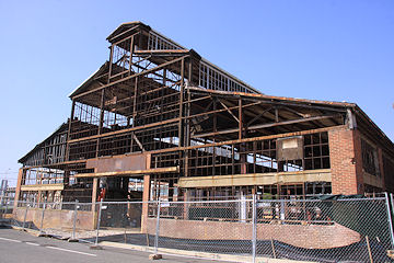
At the Yards, the Foundry Lofts (left) are looking close to done, and it's striking to compare it to its Before shots to see just how well the exterior of the building has been cleaned up. Meanwhile, the Boilermaker Shops (right) is now defrocked, with work underway to transform it into the 46,000-square-foot retail space that will open about a year from now.


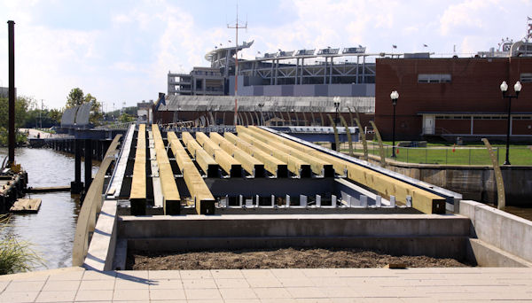
In the Yards Park, work will start this fall to make the Lumber Shed into another retail space, and earlier this summer test panels were hung on one corner of the building (left) to show how currently bare structure will look when it is completely enclosed in glass. And, over on the western edge of the park, the new bridge that will connect Yards Park to Diamond Teague Park (and Nationals Park) is coming along (right), with a number of the signature curved "fence posts" already installed. The bridge is scheduled to open in a few months.
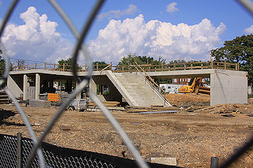
I finally got some not-very-exciting shots of the under-construction pavilion on the south end of Canal Park (left), along with updating what photos I could of the perimeter (the fencing around 2nd Place in particular puts a cramp in my methodology). This pavilion is where a restaurant is planned, which could be home to the latest Xavier Cervera offering if a deal is finally reached. The park is expected to open next year. Plus, I captured the temporary home of the Capitol Hill Day School (right), so that some day many years from now there will be a record of the modular classrooms that stood for nine months or so on the site of the eventual Capper Community Center at 5th and K.
And change is happening at a ridiculously rapid pace at Capitol Quarter, so much so that a trip through the Phase 2 Extended Photo Archive is definitely recommended to see all of the new vistas in comparison to the old Capper footprint. Less showy but still moving forward is the transformation of 225 Virginia/200 I, including the beginnings of the work on the parking deck at 3rd and I.
Want to plow through all 213 new images? Have at it.
|
Comments (1)
|
Apologies for the torrent of words that follows:
* ANC Meetings: The agenda is now out for Monday's meeting ANC 6D meeting. In addition to the Capper apartments time extension request I just wrote about, there will be a discussion of the proposed Single Member District boundaries for 6D. (Ditto on both counts for the ANC 6B meeting the next night.) There is also an agenda item on the proposed renaming of both the Navy Yard and Waterfront-SEU Metro stations, with a DDOT representative. The 6D meeting is at 7 pm in the DCRA offices at 1100 4th St., SW, 2nd Floor.
* Changes to P1/P2/P6 Buses: WMATA has come up with a list of proposed changes to bus routes, and one of them would eliminate the P1 and P2 buses that run along M Street SE during rush hour and would re-route the P6 bus down M Street SE to 4th Street SW, away from its current route that runs along Virginia Avenue and through the southern part of Capitol Hill before heading to Federal Center SW and then across the Mall and into downtown. This could impact the residents of the Capper Seniors building at 900 5th St., SE, which has an eastbound stop right on its corner. (I'd also note that the planned closure of Virginia Avenue south of the freeway for two-plus years would necessitate a rerouting anyway.) And, in the interest of full disclosure, I'll say that this rerouting would have an impact on the JDLand household, since we often use this bus (which stops right at our corner) to get to and from downtown. This is not final yet, with public meetings on this and the other proposed changes still to come.
* NCPC Doings: Last week the National Capital Planning Commission approved by consent Forest City's plans to temporarily put their offices in the second floor of the Lumber Shed building at the Yards Park. NCPC also approved an installation of solar panels at the Navy Yard, while humminah-hummining that though the commission had said back in 2010 that "no future submittals at the Washington Navy Yard will be considered until an updated master plan is submitted," they decided that "this proposal is a minor one that does not increase the population at the installation, does not include any interior space, will have 'no adverse effect' on historic resources and is comprised of elements that reduce the installation's energy consumption." Plus, the report says the commission staff has been meeting with the Navy and expects a draft document for updating the Navy Yard master plan to be submitted to NCPC by the end of this year.
* Beer! And a Cookout: In tastier news, the folks at Harry's Reserve tell me they are now approved to sell single beers, and already are building their inventory of 32-40 oz craft beers, imports, and the like. Meanwhile, the Great Heartland Cookout is happening on Saturday at the Yards Park, benefitting the Fisher House Foundation, which donates "comfort homes" built on the grounds of major military and VA medical centers for families of hospitalized service members. Cookout tickets start at $40.
* Crime At Capper, Before and After: The Urban Institute has published "Movin' Out: Crime Displacement and HUD's HOPE VI Initiative" that uses the crime statistics around Capper and other DC rehabilitated public housing communities to show that crime not only remains low in the immediate area after a HOPE VI renovation, but is lower in nearby areas as well. The report is a bit hard to read (I have to admit I gave up pretty quickly), but MetroTrends gives a good summary. You can also look at the crime statistics I've archived since 2005 to see how crimes in the neighborhood have changed over the years, while keeping in mind that the initial move-outs began at Capper in 2003. (The huge spike in Theft from Autos in 2006 was mostly a result of the neighborhood being empty except for the cars of construction workers, which were then pretty easy pickings during the daytime when they were busy at Nationals Park or the other projects at the time.)
* Waah Waah Waah: And, speaking of the crime statistics.... I have been downloading those reports from the city's Data Warehouse on a near-daily basis since they were first made available as XML feeds. I've also been able to get Public Space Permit Applications and Approved Building Permit Applications via XML for a number of years, and the many data feeds that were created are something that the city received numerous accolades for during the Fenty administration. However, the Public Space Permits feed now has not been updated since mid-July, and the Building Permits feed hasn't been updated since August 23.
Multiple e-mails to the data warehouse e-mail address have gone unacknowledged (after years of pretty prompt response, even if it was just to say "we know, we're working on it"). The Twitter accounts for both the Data Warehouse project and for OCTO Labs are equally moribund. I've let DCRA and DDOT know about the problems with the feeds, since they are the originators of the data, but if these data feeds are going to go to seed it's going to be a real loss for having easy access to this sort of data (even if I'm probably one of the few people who's ever bothered to take advantage). And, if the data isn't dying and is just getting worked on, a little bit of communication would go a long way (like, say, replying to any of my e-mails). Hopefully the crime feeds won't suddenly stop working, since that one certainly gets the most interest of any of them. (My complaints about the loss of depth in the city's web site offerings after the big redesign are for another day.) Just wait until OCTO moves into 225 Virginia next year and I can start picketing out front.
|
Comments (1)
More posts:
ANC News, Capper, Capper Seniors/900 5th St., crime, Harry's Reserve, meetings, Navy Yard, JDLand stuff, The Yards, Yards Park
|
2682 Posts:
Go to Page: 1 | ... 5 | 6 | 7 | 8 | 9 | 10 | 11 | 12 | 13 ... 269
Search JDLand Blog Posts by Date or Category
Go to Page: 1 | ... 5 | 6 | 7 | 8 | 9 | 10 | 11 | 12 | 13 ... 269
Search JDLand Blog Posts by Date or Category